
Advanced Quantitative Precipitation Information
 |
 |
 |
 |
AQPI and NWS Radar |
AQPI User Interface |
CW3E Watershed Precipitation Forecasts |
CW3E West-WRF Forecasts |
Background
The Advanced Quantitative Precipitation Information (AQPI) system is a regional project that uses enhanced weather radar to track atmospheric river precipitation. AQPI was funded in 2016 by a grant from the California Department of Water Resources (DWR) Integrated Regional Water Management Program (IRWM) awarded to Sonoma Water and participating Bay Area agencies. The National Oceanic and Atmospheric Administration (NOAA) and the Cooperative Institute for Research in the Atmosphere (CIRA) are building the AQPI system and delivering the AQPI end-product to these agencies. When completed, the goal of the AQPI system will be to provide X-Band and C-Band weather radar information that will increase the accuracy of weather forecasting and response systems throughout the Bay Area. Improved forecasting will assist flood agencies, emergency responders, wastewater plant managers, reservoir operators, and water managers in responding to extreme weather events in a timely fashion. A Local Partner Agency Committee (LPAC) has formed to develop the AQPI framework for regional collaboration. The University of California San Diego, Scripps Institution of Oceanography, Center for Western Weather and Water Extremes (CW3E) is working with the LPAC member agencies to develop an operations plan and transition plan for the AQPI system. CW3E will operate the system when the DWR grant period ends in early 2024.
AQPI Case Study: Winter 2022/2023 Atmospheric River Storms in Santa Cruz County
The Challenge
When big storms like atmospheric rivers hit California, current technology does not provide the detailed information needed to inform reservoir operations, flood protection, combined sewer-stormwater systems, and emergency preparedness. Standard weather radars, designed to look up into severe thunderstorms, are often unable to give an accurate picture of what is happening just above the complex landscape of California’s coastal mountain ranges, where precipitation can be heaviest.
Accurate and timely precipitation information is critical for making decisions regarding public safety, infrastructure operations, and resource allocations. Improved monitoring and prediction of heavy rain in the Bay Area can enhance public safety when hazardous weather events come onshore. That is the goal of AQPI.
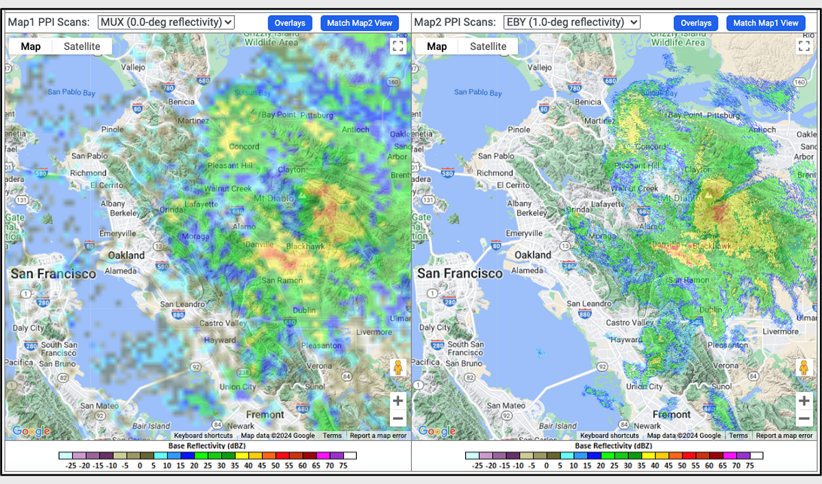
Real-Time Radar Display: watch the radars in action now!
Radar Locations
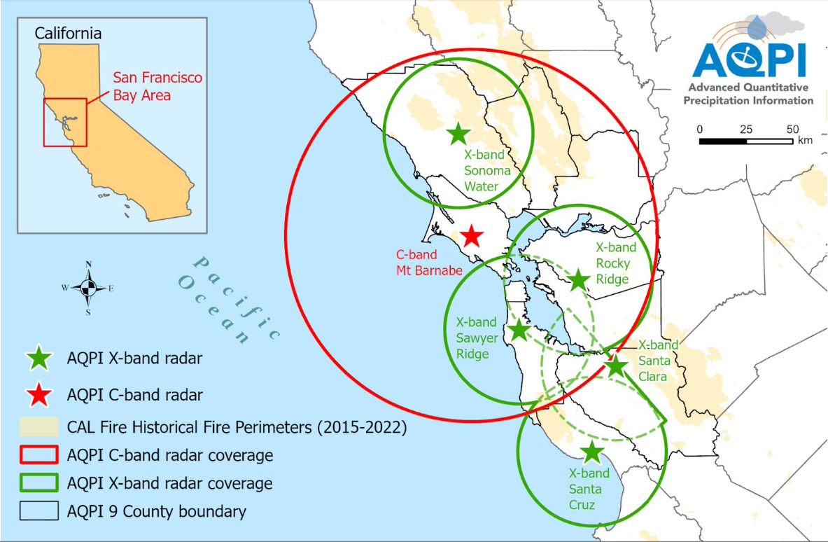
When completed, the DWR funded project will have installed four X-Band radars and one C-Band radar that will cover most watersheds in the Bay Area (Figure A). At least one, and possibly two, additional X-Band radars (not funded under this IRWM grant) will provide data to the AQPI system. See Figure A below for a map with radars and coverage of the Bay Area AQPI system, when deployments are completed. The X-Band Terminal Tank location is possible, but not confirmed.
Timeline for Radar Deployment
As of Winter 2022/2023, four X-Band radars are operational. These radars are located in Sonoma, Santa Clara, Contra Costa, and Santa Cruz Counties. Additional X-Band radars will be deployed in San Mateo in 2023 and (potentially) Sonoma County in 2024. The C-Band radar is planned to be located on Mt. Barnabe in Marin County in 2023. Radar locations include:
- Sonoma Water – Operated a temporary X-band radar since 2018, located near the Sonoma County Airport. A permanent X-Band radar was deployed in March 2023 at the same location.
- Valley Water – Operated a temporary X-Band radar since 2016, located at the Penitencia Water Treatment Plant. A permanent X-Band radar was deployed in July 2019 at the same location.
- San Francisco Public Utilities Commission (SFPUC) – Plans to deploy a permanent X-Band Radar on Sawyer Ridge in San Mateo County by Winter 2023.
- East Bay Agencies Partnership – In December 2022, a partnership of East Bay agencies deployed an X-Band radar on Rocky Ridge, adjacent to the Las Trampas Wilderness area. The Rocky Ridge radar will be operational in Winter 2023. This partnership includes East Bay Municipal Utility District, East Bay Dischargers Authority, Contra Costa County Flood Control & Water Conservation District, Alameda County Flood Control & Water Conservation District, Alameda County Water District, and Zone 7 Water Agency.
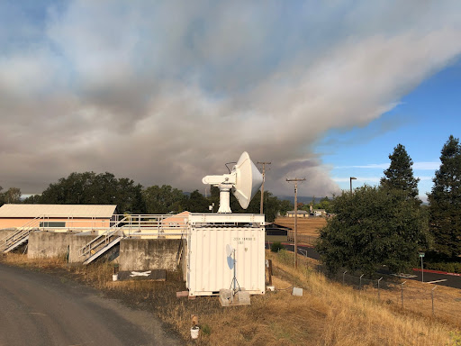
- Santa Cruz County Flood Control and Water Conservation District – Deployed an X-Band radar on a county building in August 2022, funded through a grant from DWR’s Statewide Flood Emergency Response Grant program. The radar will send data to the AQPI system.
- Sonoma Water – May receive a grant from FEMA’s Hazard Mitigation Grant Program to deploy an X-Band radar at the Geysers Recycled Water Tank site, managed by the City of Santa Rosa. This radar will send data to the AQPI system.
- C-Band Radar – Regional partners are collaborating to deploy a C-Band radar on the peak of Barnabe Mountain in western Marin county. The C-Band radar will cover the Pacific Coast and also areas inland to complement the X-Band radars, improving precipitation and stream flow forecasting throughout the region.
AQPI Benefits to the San Francisco Bay Area
Flooding is a major concern in the Bay Area and AQPI addresses this concern. See Figure A below, where AQPI X-band radar provides a more accurate picture of rainfall in Santa Rosa. This is just one example of many in which AQPI X-band radar provides more detailed and accurate information about precipitation intensity.
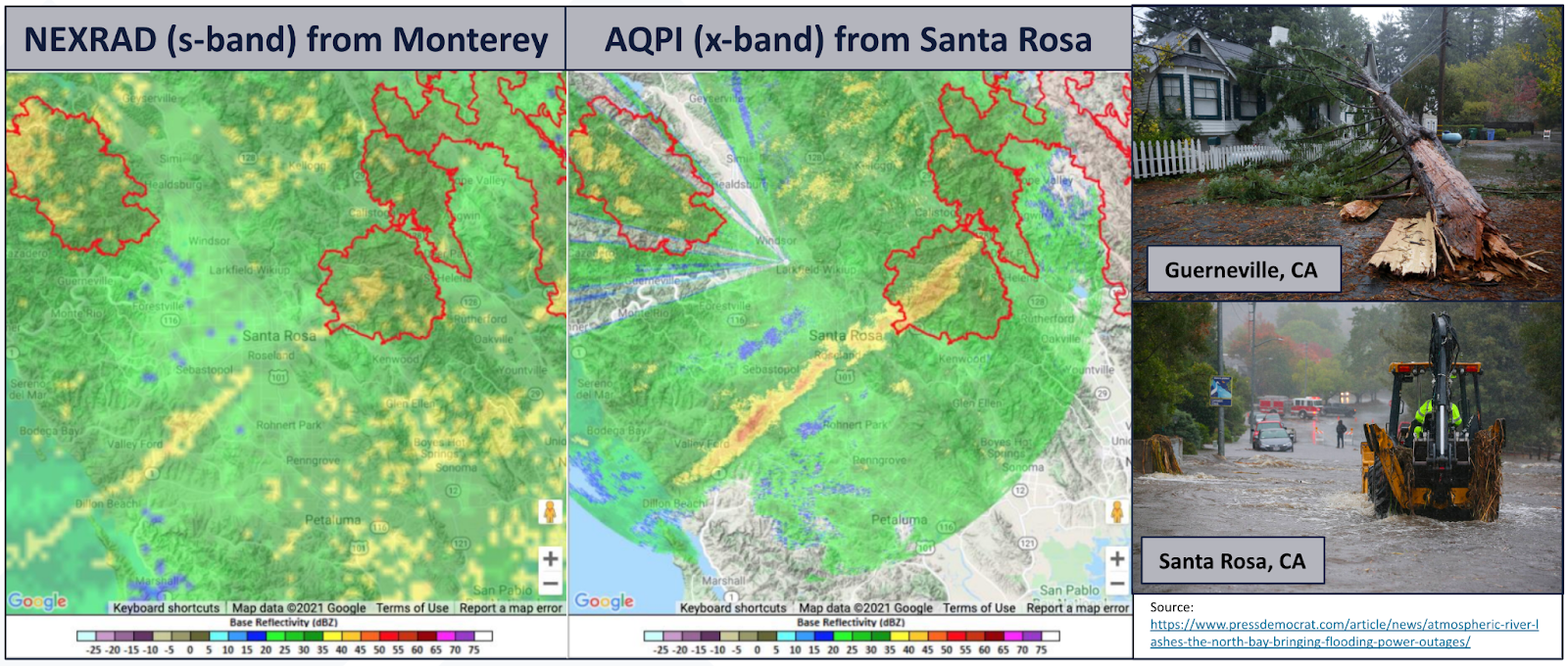
Figure A: Weather radar for the Sonoma County area on the afternoon of October 24, 2021, as seen by standard radar (left panel) and AQPI X-band radar (central panel). The city of Santa Rosa is in the center of the images and burn areas are outlined in red. Note the presence of a narrow cold-frontal rain band (NCFR) that is clearly seen in the AQPI X-band radar, but not in the standard radar. This NCFR produced very heavy rain rates causing urban flooding throughout the city of Santa Rosa and nearby locations (photos at right).
Along with enhanced radar data, AQPI provides several other benefits such as high-quality precipitation estimates, increased forecast lead time via the C-band radar (in 2024) and in the future, better short-range weather model forecasts as AQPI radar data is integrated into forecast models.
AQPI System Information and Data
Information:
NOAA AQPI Wepbage: https://psl.noaa.gov/aqpi/
Sonoma County Water Agency AQPI Webpage: https://www.sonomawater.org/aqpi/
Data Access:
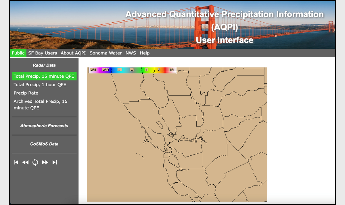
AQPI User Interface: real-time data for Bay Area stakeholders
Real-Time Radar Display: watch the radars in action now!
Contact Information
Jonathan Rutz, Center for Western Weather and Water Extremes
Science, Meteorology, Forecasting
Dale Roberts, Sonoma County Water Agency
Engineering