Background
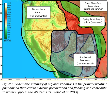
The West experiences a wide range of storms that cause much of the extreme precipitation and flood risk in the region (Figure 1). The summer monsoon influences mostly the southwest, while “upslope storms” are key in the “Front Range” of the Rockies as are the large thunderstorms that hit the Great Plains and Front Range areas. Atmospheric rivers dominate extremes along the west coast. Some of these phenomena have received great attention scientifically and for forecasting (thunderstorms and upslope storms on the Front Range), while atmospheric rivers and the monsoon have received much less focus. This is especially true of atmospheric rivers. The past decade of research has shown that most of the extreme precipitation and flooding events in California (and other areas of the west), and much of the snowpack and water supply are associated with Atmospheric Rivers (AR); http://www.esrl.noaa.gov/psd/atmrivers/). ARs:
- are the dominant cause of flooding and play key roles in drought in US West Coast watersheds (flood costs average about $1 B/year
- produce 25-50% of the water supply in key areas of the West (with $10s of billion/year in benefits)
- could be well monitored with modern sensors (land or buoy-based, airborne, and satellite), and
- could be forecast within useful precision and lead time (using modern weather prediction models).
- For more information on ARs visit the AR FAQs or watch this informational video about ARs.
This progress has inspired recognition that major benefits could accrue with establishment of a long-term research and application capability focused on western weather and water issues, with special emphasis on atmospheric rivers. The Western States Water Council has formally recommended focused research, monitoring, prediction and climate trend detection tailored to the Western U.S. Our response to these findings and advances, and this recommendation, is establishment of a Center for Western Weather and Water Extremes led by Scripps Institution of Oceanography and in partnership with federal (e.g., NOAA and USGS), state (e.g., the California Department of Water Resources and California Energy Commission), and local (e.g., Sonoma County Water Agency, and San Francisco Public Utilities Commission), as well as the Hydrometeorology Testbed (HMT). This Center is building upon and strengthening existing facilities and staff, will engage Cooperative Institutes, support numerical modeling, experimental forecasting and specialized data collection using both a long-term network and periodic field experiments with partners, and existing and emerging airborne and satellite sensors in collaboration with NASA, NOAA and DOE.
Initial Technical Aims
- Taking full advantage of the unique California-wide network of specialized HMT observations.
- Developing an observing network optimized for extreme events in the Western U.S.
- Leading field experiments in the west, e.g., “CalWater 2”, including research aircraft deployments.
- Optimizing a version of the WRF weather modeling system for Western U.S. extreme events.
- Develop methods to use information about physical processes, such as ENSO and MJO, that could support probabilistic long-lead forecasts of extreme events, e.g., with 10 day, to 2 month lead times
- Determining how extreme events and their roles in water supply, hydropower & flood may change.
- Providing extreme-event information of ecosystem science, management strategies and planning.
Core capabilities to be established
- California Demonstration System (CDS) – observations, models, science and decision support tool development occurs here with partners and observations already in place and where the “Bay Delta” levee system is vulnerable to failure from a strong AR (putting at risk the water supply required by 2/3 of the states population and affecting the 8th largest economy in the world; 80% of historical Central Valley levee breaks have been directly associated with AR-generated floods).
- Western Research and Applications Capability (WRA) – applies lessons from CDS to the Western U.S., implementing elements of the WSWC-requested “Western Observing System Vision;” provides quantitative data to improve water management (especially key in a changing climate).
Required technical competencies
- Weather and hydrologic science, modeling, predictions, and applications expertise.
- Climate science, modeling, predictions, trend analysis, and user needs expertise.
- Prototyping, demonstration and evaluation of potential operations tools and methods.
- Observing system engineering for network design, field experiments, and to develop sensors.
- Ability to exploit remote sensing data from aircraft, satellite and ground-based sensors.
- Research aircraft field campaign expertise and capacity.

