Forecast Informed Reservoir Operations
FIRO is a reservoir-operations strategy that better informs decisions to retain or release water by integrating additional flexibility in operation policies and rules with enhanced monitoring and improved weather and water forecasts (American Meteorological Society; 2020).
FIRO is being developed and tested as a collaborative effort in the Russian River Basin (Lake Mendocino, Lake Sonoma), the Santa Ana River Basin (Prado Dam, Seven Oaks Dam), the Yuba-Feather River Basins and the Green River (Howard Hanson Dam) that engages experts and stakeholders in civil engineering, hydrology, meteorology, biology, economics and climate from several federal, state and local, universities and others. There is significant interest and support for developing FIRO at other appropriate locations in the Western U.S. and elsewhere.
 |
 |
 |
 |
 |
 |
 |
 |
 |
|
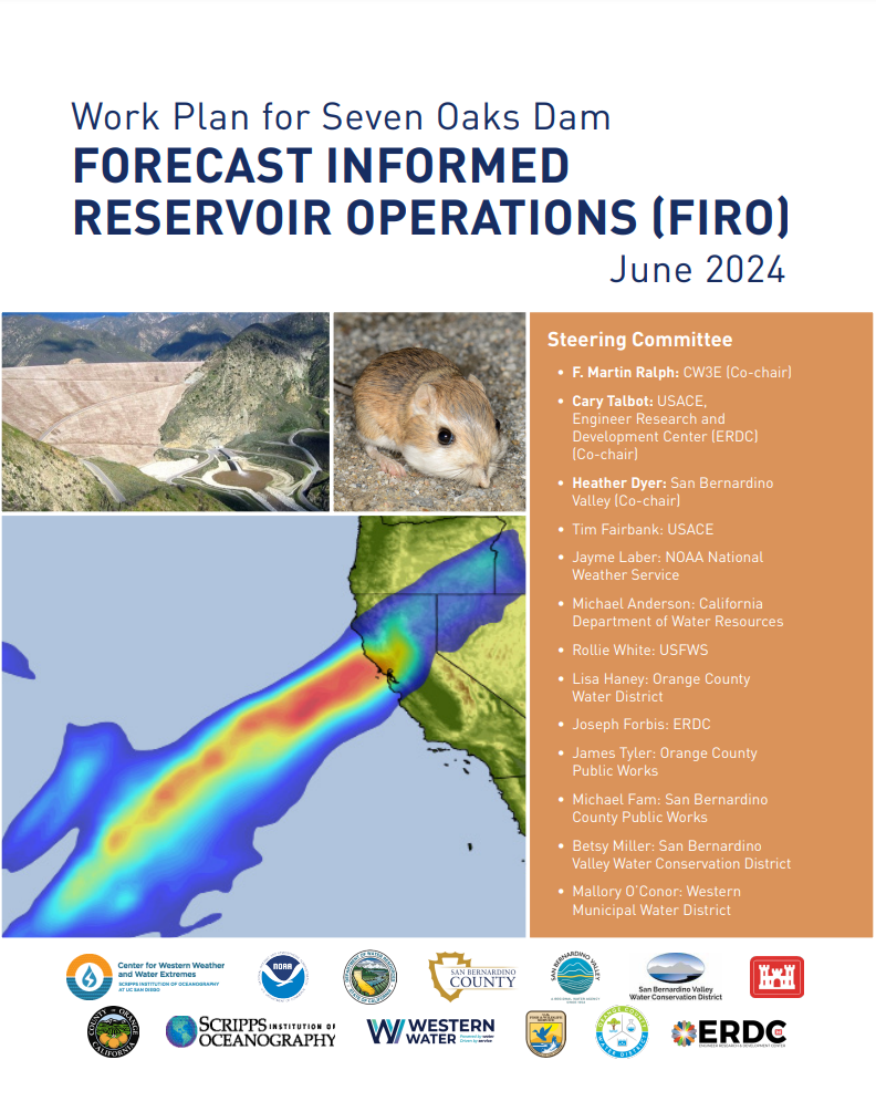
Steering Committee Co-Chairs Heather Dyer (San Bernardino Valley Municipal Water District) F. Martin Ralph (Center for Western Weather and Water Extremes at Scripps Institution of Oceanography) Cary Talbot (US Army Corps of Engineers, Engineer Research and Development Center) Members Michael Anderson (California State Climate Office, Department of Water Resources) Brendon Biggs (San Bernardino County Public Works Tim Fairbank (US Army Corps of Engineers) Joseph Forbis (US Army Corps of Engineers) Mallory Gandara (Western Municipal Water District) Lisa Haney (Orange County Water District) Jayme Laber (NOAA National Weather Service) Betsy Miller (San Bernardino Valley Water Conservation District) James Tyler (Orange County Public Works) Rollie White (US Fish and Wildlife Service) Support Staff Duncan Axisa (Center for Western Weather and Water Extremes at Scripps Institution of Oceanography) Leo Ferrando (San Bernardino Valley Municipal Water District) Rob Hartman (RKH Consulting Services) Wen Huang (San Bernardino Valley Municipal Water District) Chris Jones (San Bernardino Valley Municipal Water District) Janel Mayo (Center for Western Weather and Water Extremes at Scripps Institution of Oceanography) Arleen O’Donnell (Eastern Research Group) Gerg Woodside (San Bernardino Valley Municipal Water District) |
Seven Oaks Dam 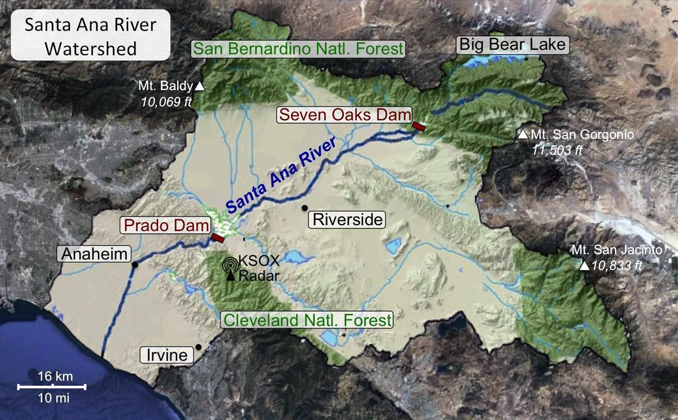
Figure 1. Map of the Santa Ana River watershed. Located on the Santa Ana River, Seven Oaks Dam (built in 2000 to store 145,600 ac-ft), in tandem with Prado Dam, prevents flood-related damages from extreme precipitation events in Orange, Riverside, and San Bernardino Counties. These events have typically been driven by strong and long-lasting atmospheric rivers (AR) storms.. Operations at Seven Oaks Dam and Prado Dam have historically accounted for such storms, but recent advances in understanding how ARs work, and how to better predict them, yield the potential to enhance water supply reliability and flood risk management, and other co-benefits such as habitat. The 2,450 square mile (6345 square kilometer) Santa Ana River watershed flows from the San Gabriel, San Bernardino, and San Jacinto Mountains, to its terminus at the Pacific Ocean. These mountains form a barrier to ARs that originate in the Pacific and make landfall in Southern California, forcing moist flow upward and generating clouds and precipitation. Rainfall accumulation during several AR storms per winter season accounts for 40-50% of annual precipitation, with large interannual variability in total precipitation arising due to differences in AR activity. In May, 2023, the Center for Western Weather and Water Extremes (CW3E), San Bernardino Valley Municipal Water District (SBVMWD), and the U.S. Army Corps of Engineers (USACE) Engineer Research and Development Center (ERDC) convened an inter-agency effort to assess the viability of Forecast Informed Reservoir Operations (FIRO) at Seven Oaks Dam. FIRO leverages research on atmospheric river storm dynamics and physical processes, which are necessary for improving precipitation and inflow predictions. FIRO at Seven Oaks Dam will investigate the key question: Can current and improved forecasts of landfalling atmospheric rivers and other storm types and their associated precipitation, temperature and runoff be used to inform flexible reservoir operations at Seven Oaks Dam to store more water to improve habitat and water supply reliability, while maintaining or potentially improving flood risk management? 
Figure 2. Image of Seven Oaks Dam. This project creates a process to explore the potential for FIRO at Seven Oaks Dam, and will be informed by the approaches developed for Lake Mendocino, Prado Dam and the Yuba-Feather FIRO projects, and will be carefully coordinated with Prado Dam FIRO, also within the Santa Ana River watershed. American Meteorological Society, cited 2020: Forecast-informed reservoir operations. Glossary of Meteorology. [Available online at http://glossary.ametsoc.org/wiki/Forecast-informed_reservoir_operations.] |