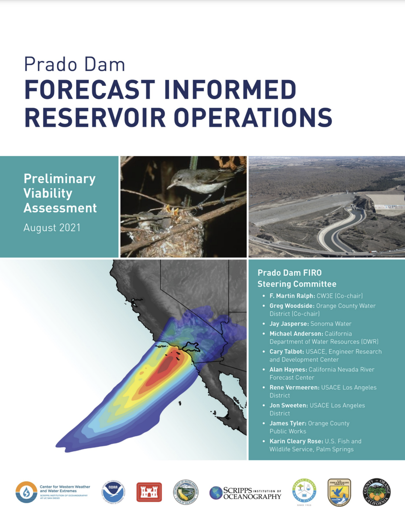
Forecast Informed Reservoir Operations
FIRO is a reservoir-operations strategy that better informs decisions to retain or release water by integrating additional flexibility in operation policies and rules with enhanced monitoring and improved weather and water forecasts (American Meteorological Society; 2020).
FIRO is being developed and tested as a collaborative effort in the Russian River Basin (Lake Mendocino), the Santa Ana River Basin (Prado Dam), and the Yuba-Feather River Basins that engages experts and stakeholders in civil engineering, hydrology, meteorology, biology, economics and climate from several federal, state and local, universities and others. There is significant interest and support for developing FIRO at other appropriate locations in the Western U.S. and elsewhere.


| |
 |

| |
 |

| |
|
Steering Committee Co-Chairs Greg Woodside (Orange County Water Distrcit) F. Martin Ralph (Center for Western Weather and Water Extremes at Scripps Institution of Oceanography) Members Michael Anderson (California Department of Water Resources) Cary Talbot (US Army Corps of Engineers) Alan Haynes (Caifornia Nevada River Forecast Center, NWS) Jon Sweeten (US Army Corps of Engineers) James Tyler (Orange County Public Works) Karin Cleary-Rose (US Fish and Wildlife Service) Tim Fairbank (US Army Corps of Engineers) Duncan Axisa (Center for Western Weather and Water Extremes) Rachel Weihs (Center for Western Weather and Water Extremes) Support Staff Adam Hutchinson (Orange County Water District) Arleen O’Donnell (Eastern Research Group) Robert Hartman (RKH Consulting Services) Related Documents |
Prado Dam Preliminary Viability Assessment Water Supply Reliability Expected to Improve at Southern California’s Prado Dam New trial for using advanced weather forecasts to retain more water proves successful As drought persists in the state of California, the need to increase water supply reliability is an essential issue facing water managers. A new report evaluating a pilot program to use advanced weather and streamflow forecasts to enhance water storage capabilities at a Riverside County, California, dam found that enough water could be conserved to supply an additional 60,000 people per year. The pilot program, called Forecast-Informed Reservoir Operations (FIRO), led by research meteorologists from the Center for Western Weather and Water Extremes at UC San Diego’s Scripps Institution of Oceanography, found that 7,000 acre-feet per year of stormwater could potentially be added to groundwater recharge in Orange County. One acre-foot is equivalent to about 325,000 gallons. The program was supported by a combination of funds from the U.S. Army Corps of Engineers (USACE), Orange County Water District, and the California Department of Water Resources (DWR). 
Prado Dam. Photo: USACE “We are excited to partner with Scripps and the U.S. Army Corps of Engineers on this project, which increases water supply and reliability for the region,” said Orange County Water District President Steve Sheldon. “Local stormwater capture is important because it lessens demand on imported water supplies, which are more costly and less reliable than groundwater.” The District manages the Orange County Groundwater Basin, which provides 77 percent of the water supply to 2.5 million people in north and central Orange County. It also manages a six-mile stretch of the Santa Ana River between Prado Dam and its recharge basins in Anaheim. “The Prado Dam FIRO project is an example of the continued partnerships between state, federal and local agencies. The FIRO program has shown that by better utilizing emerging technologies in observations and forecasts to create an adaptive strategy, we can improve water management, not only during the wet years, but during drought conditions as well,” said Kris Tjernell, DWR’s Deputy Director for Integrated Watershed Management. “This type of project perfectly aligns with the goals described in the Governor’s Water Resilience Portfolio and is also the type of multi-benefit project that uses common sense approaches, combined with the latest science, to embrace innovation and new technologies, and increase resilience to climate change.” 
Schematic representation of Prado Dam water conservation elevation for stormwater storage and capture. Prado Dam was constructed in 1941 by USACE for flood risk management, with a secondary benefit of stormwater capture for water supply. Many dams in the west, including Prado Dam, are regulated by USACE-issued water control manuals, which do not take advantage of modern precipitation and streamflow forecasting capabilities. FIRO is a research and operations partnership that uses data from watershed monitoring, and modern weather and hydrologic forecasting, specifically the study of atmospheric rivers, to help water managers selectively retain or release water from reservoirs in a manner that reflects current and forecasted conditions. 
Radar imagery showing precipitation associated with an atmospheric river making landfall over Southern California during February 2017. Black outline shows the Santa Ana River watershed. “Atmospheric river storms cause 25 to 50 percent of annual precipitation in key parts of the west, which can replenish water supply, but can also lead to hazardous and costly flooding,” said Marty Ralph, PhD, director, Center for Western Weather and Water Extremes, Scripps Oceanography. “When atmospheric rivers make landfall, they can release a staggering amount of rain and snow; however, their absence can lead to drought.” The science of forecasting atmospheric rivers has continued to advance. Research conducted by Scripps Oceanography includes atmospheric and soil moisture observations; data collection over the Pacific Ocean, including measurements from buoys and dropsonde deployments into approaching storms; and advanced modeling that allows for better assessment of uncertainty in forecasts. Using models to simulate reservoir operations under FIRO conditions, the assessment found that temporarily storing water to higher elevations can enhance groundwater recharge. The improvements in atmospheric river forecasts show high reliability at up to five days’ lead time, which allows dam operators to make timely water releases and could enhance flood-risk management. “Completion of the preliminary viability assessment for Prado Dam is an important milestone for the U.S. Army Corps of Engineers as it builds our understanding of how to safely and effectively implement this important policy change across the agency,” said Cary A. Talbot, a division chief at the U.S. Army Engineer Research and Development Center and FIRO program manager for the Corps. “FIRO pilot sites like Prado Dam add to our agency’s ability to find a better balance between flood-risk management, water supply and ecological benefits, and makes us more resilient for the challenges of a changing climate.” The USACE’s Los Angeles District, which maintains Prado Dam, agreed with the potential for FIRO to enhance operations. “For several decades, Prado Dam has served its purpose well,” said David Van Dorpe, deputy district engineer for USACE Los Angeles District. “The dam has reduced the flood risk for Orange County, while also balancing water conservation, ecological and recreational benefits. FIRO provides an opportunity to further enhance our operations to meet all of these needs.” The report comes on the heels of the successful final viability assessment at Lake Mendocino earlier this year, with FIRO operations that resulted in 20 percent increased water. USACE and the Center for Western Weather and Water Extremes also are actively assessing FIRO opportunities in other watersheds where atmospheric rivers are dominant, including New Bullards Bar Reservoir in Yuba County, California, Lake Oroville in Butte County, California, as well as the Howard Hanson Dam near Seattle, Washington. Photo and video assets: Photo and video assets are available to view and download. Tour requests: Media tours of Prado Dam can be coordinated through the U.S. Army Corps of Engineers Los Angeles District Public Affairs at (213) 452-3925 or by emailing publicaffairs.spl@usace.army.mil. Suggested Citation: American Meteorological Society, cited 2020: Forecast-informed reservoir operations. Glossary of Meteorology. [Available online at http://glossary.ametsoc.org/wiki/Forecast-informed_reservoir_operations.] |