Subseasonal and Seasonal Prediction of Extreme Weather
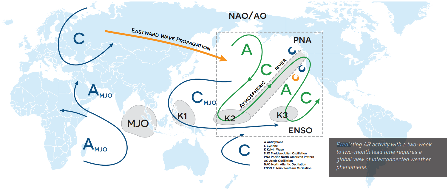
CW3E aims to improve understanding of the S&S predictability of ARs and become a regional leader in producing experimental S&S outlooks of ARs over the western United States.

Figure adapted from Ralph et al. 2011
Key Objectives:
- Apply artificial intelligence and post-processing techniques to improve S&S AR and precipitation prediction skill.
- Increase understanding and improve skill in forecasting synoptic weather precursor patterns over the western United States that modulate S&S AR and precipitation occurrence and magnitude.
- Develop and maintain experimental S&S AR outlooks in close coordination with stakeholders.
Challenges and solutions:
Lead times of two weeks to two months represent critical decision-making windows for water resource managers and other end-users of weather and climate information. This is especially true in the western United States because of the region’s high year-to-year precipitation variability. CW3E is working to better understand and improve S&S AR and extreme precipitation prediction skill in partnership with the NASA Jet Propulsion Laboratory (JPL) and in collaboration with the European Centre for Medium-Range Weather Forecasts (ECMWF) and various universities (e.g., the University of Colorado Boulder).
With support from California DWR and the United States Army Corps of Engineers, and in partnership with NASA JPL, CW3E has developed a suite of subseasonal and seasonal experimental AR, precipitation, and ridging outlooks that make probabilistic forecasts from dynamical models run at leading forecasting centers, and statistical models developed by our research group. CW3E is continuing to assess the accuracy and associated uncertainty of various forecast products at different lead times in a peer-reviewed research framework.
Over the next five years, CW3E will conduct fundamental research on S&S AR prediction skill using existing hindcast ensemble datasets, explore the use of machine learning and post-processing techniques to improve S&S ensemble prediction of ARs and extreme precipitation, investigate synoptic precursor patterns that are conducive to “forecasts of opportunity” for extended prediction of ARs and precipitation, make a focused effort on S&S forecasts for the Upper Colorado River Basin, and further develop and refine the S&S week-three AR experimental outlook tools with direct input from stakeholders at DWR.
Key Results:
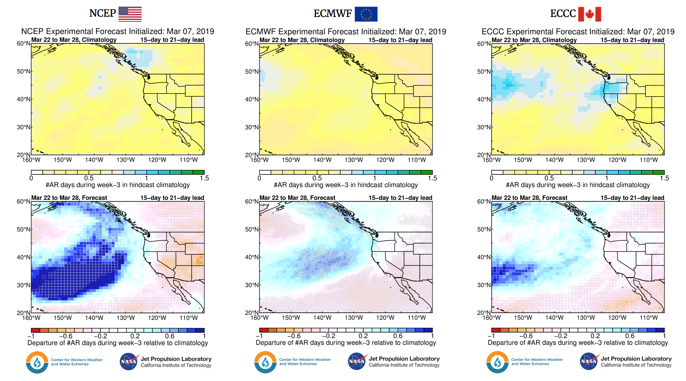
CW3E has developed a week-2 and week-3 experimental atmospheric river (AR) outlook that incorporates probabilistic forecasts from dynamical models run at leading forecasting centers, including the U.S. National Centers for Environmental Prediction (NCEP), the European Centre for Medium-Range Weather Forecasts (ECMWF), and the Environment and Climate Change Canada (ECCC). It also includes statistical forecasts made from the current weather and climate conditions. CW3E is continuing to asses the skill of the different forecast products at different lead times. The results from two studies lead by CW3E researcher, Mike DeFlorio, are highlighted below.

Figure 1: Sample multi-model experimental outlook from March 7, 2019 forecast, as displayed on the CW3E Week-3 protected website for the NCEP, ECMWF, and ECCC forecast systems. The top row shows climatological values of AR occurrence in each model’s hindcast record for the week-3 verification period. The bottom row shows the departure of the AR occurrence forecast for that same verification period (forecast minus top panel climatology). For this row, blue values represent higher than average AR activity predicted during week-3; red values represent lower than average AR activity predicted during week-3. Grey rectangles surround grid cells where >75% of forecast ensemble members agree on the sign of the AR occurrence anomaly with respect to climatology. These regions can be interpreted as having higher confidence in their prediction of week-3 AR occurrence. (Figure 12 from DeFlorio et al. 2019b).
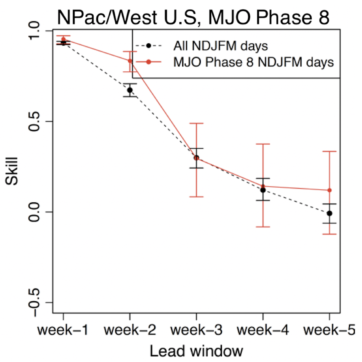
DeFlorio et al. (2019a) evaluated the global prediction skill of the ECMWF hindcast system for the occurrence of atmospheric rivers (ARs). Figure 2 shows that hindcasts of AR occurrence over the North Pacific/Western U.S. region have significant skill above climatology at lead times of one and two weeks, have slightly more skill than climatology at week-3 lead time. DeFlorio et al. (2019a) also showed that prediction skill of AR occurrence at various S&S lead times in the ECMWF hindcast system is increased when hindcasts are initialized during certain phases of the Madden Julian Oscillation (MJO) and other modes of climate variability. Figure 3 shows that hindcasts which are initialized during phase 8 of the MJO are associated with more skillful prediction of AR occurrence over the North Pacific/Western U.S. region 8-14 days later (week-2 lead time). Understanding these “forecasts of opportunity” when S&S prediction skill may be higher than the average prediction skill is important for weather forecasters and users of these extended range forecasts.
Our S&S team has also performed a multi-model hindcast skill assessment of atmospheric river (AR) activity over the western United States at S&S lead times ranging from 1-week to 1-month in the ECMWF, ECCC, and NCEP hindcast systems (DeFlorio et al. 2019b). This assessment provides hindcast skill benchmarks for multi-model experimental S&S AR forecasts that our team is creating. In particular, our work identified several forecasts of “opportunity” and forecasts of “avoidance”, where S&S skill is higher or lower than average conditions, respectively, are identified by conditioning forecasts of AR activity on phases of strong El Niño-Southern Oscillation (ENSO) and Madden-Julian Oscillation (MJO) events. An example of one such situation over Central California is shown below.

Figure 4: Schematic of Relative Operating Characteristic (ROC) statistics of AR activity (hit, miss, false alarm, correct rejection) used this study; b) ROC statistics for Central California region for all NDJFM days (black) and MJO Phase 8 initial condition composite (red) as a function of week-long lead window (symbols) in the ECMWF hindcast system. (Figures 2 and 9 From DeFlorio et al. 2019b).
CW3E has applied, tested and implemented a longstanding optimized CCA-based model (OCCA)2 to develop an experimental operational seasonal precipitation prediction effort focused on the Southwestern United States. Click here for more information on this product.


