Modeling Capabilities for the Western United States
CW3E will contribute to the development and application of state-of-the-art weather, hydrology, and coupled modeling systems at spatiotemporal scales relevant to decisions about water resource and emergency management in the western United States.
Key Objectives:
A narrow cold front rain band. This image compares observed conditions (left) with output from CW3E’s West-WRF forecasting model (right).
- Further develop West-WRF as a cutting-edge numerical weather prediction system tailored to forecast precipitation over the western United States, with a focus on extreme events.
- Develop in-house hydrological modeling expertise and capabilities to better support the mission of CW3E’s main sponsors.
- Explore, develop, and test coupled weather, ocean, and hydrologic modeling systems to improve prediction of precipitation and streamflow over the western United States.
Challenges and Solutions:
CW3E will focus on advancing modeling capabilities, with a focus on the West-WRF model. We will improve physical packages based on the understanding of physical processes we and our collaborators have gained through AR research. We will also keep testing aspects such as the size of the computational domain, horizontal and vertical resolution, nesting configurations, and the potential of global modeling systems with local refinement grids.
Runoff generation and other coupled hydrological processes in flood prone watersheds is of paramount interest for water managers and forecasters. As such, CW3E will further develop its own hydrologic modeling capabilities to support research, operations, and forecasting of hydrologic extreme events through strong collaboration with the National Water Center (NWC), National Center for Atmospheric Research (NCAR), U.S. Army Corps of Engineers (USACE), San Diego State University, and other significant research partnerships. Using these tools in collaboration with state-of-the-art observations and expertise will help further the understanding of coupled atmospheric and hydrologic watershed dynamics under extreme precipitation conditions.
Skillful forecasting of oceanic and atmospheric circulation, along with modeling of hydrological processes, is essential to address a variety of societal needs associated with weather extremes. These include water resources availability, water and air pollution, coastal flooding, fisheries management, marine conservation, and energy generation. The numerical weather prediction community has been gravitating toward coupled systems for both modeling and data assimilation. Earth system models representing the coupling between the atmosphere, land, and subsurface may improve the representation of hydrologic processes, enhancing the quality of weather and hydrologic forecasts and applications such as FIRO.
Key Results:
West-WRF: West-WRF is an ongoing effort at CW3E to develop a regional weather prediction system tailored to Western U.S. weather and hydrological extremes, including heavy rainfall from atmospheric rivers. Forecasts are generated once daily between December through March by dynamically downscaling the 00 UTC 0.25° GFS global forecasts, which are used as input and lateral boundary conditions. Hourly output of the forecasts extends out to 168 hours on the 9 km domain and 120 hours on the 3 km domain. Updated and newly designed graphics from the forecasts are publicly available here.
Martin et al. (2018) provides the first detailed description of the West-WRF configuration and validation of the model during catalogued AR events. West-WRF adds value to forecasted fields over the global forecast model that it is being downscaled from, especially for orographic precipitation and horizontal vapor transport. Improvements to precipitation forecasts during AR landfall events can be found through both better tuning of model physics parameterizations and more accurate input fields of lower-level water vapor flux.
30-Year Reforecast: The California-Nevada River Forecast Center (CNRFC) uses the 1° Global Ensemble Prediction System (GEFS) to calibrate the Meteorological Ensemble Forecast Processor (MEFP), which provides forcing for the Hydrologic Ensemble Forecast Service (HEFS). CW3E is using West-WRF to dynamically downscale 0.5° GEFS to 9 km and 3 km for a 30-year period with the goals of: 1) Assessing the benefits of a West-WRF high-resolution reforecast to CNFRC operations; 2) Enhancing CW3E predictive capabilities by exploring post processing techniques and machine learning to reduce raw model output biases; and 3) Using the reforecast product for in-depth process-based studies of ARs and other phenomena.
Hydrology: CW3E has implemented a set of distributed hydrologic models in the upper Russian River basin to investigate runoff and streamflow generation for Lake Mendocino reservoir, including NOAA’s National Water Model (NWM) configuration of WRF-Hydro and USACE Engineer Research and Development Center’s (ERDC) Gridded Surface Subsurface Hydrologic Analysis (GSSHA) model. These models are being used to assess the sensitivity of reservoir inflows to atmospheric uncertainty, runoff generation dynamics, soil moisture wet-up and dry-down behavior, rapid snowmelt generation, and model calibration techniques. Geospatial channel reach maps like those seen in Figure 1 using WRF-Hydro have been generated to assess the contribution of the inflows of the tributary branches of the Eastern Fork of the Upper Russian River during large precipitation events.These results are being used to assess the different dynamical responses of the subwatershed tributaries and their antecedent soil moisture dependencies. CW3E continues to investigate the land surface-related responses in these distributed models to isolate processes that could be improved while continually engaging with the national centers to reinforce the research-to-operations cycle.
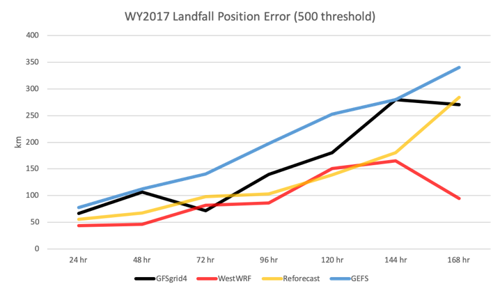
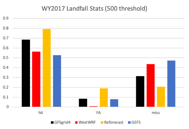
Model Verification: CW3E has a developed a multi-faceted approach towards model verification, using in-house and distributed verification tools from NCAR and NCEP. Continuous verification of multi-model integrated vapor transport (IVT) and precipitation forecasts has been developed for CW3E in order to establish forecast predictability across models of various resolutions, dynamical cores, and regional extents. The examples below in Figure 2 highlight the performance of West-WRF, the 30-Year Reforecast, GFS, and GEFS for landfalling ARs.


