
CW3E Observations
Surface Meteorology
CW3E has installed surface meteorological stations in watersheds across the western United States with the scientific goal of observing and monitoring the hydrometeorology of the western watersheds. This is particularly critical during cool-season precipitation events, including those associated with atmospheric rivers (ARs). However, our stations make continuous observations in these watersheds year-round. These stations measure a variety of variables, including temperature, relative humidity, pressure, precipitation, wind speed and direction, and solar radiation. Specific stations also measure the soil moisture and temperature at six levels within the soil profile. Other select stations also measure snow depth, fuel moisture, and fuel temperature. At each of these stations, data points are being collected at two minute intervals. Most stations provide near real-time data for situational awareness in addition to their use in accomplishing research objectives. Currently, efforts are being made to make all observations available in near real time.
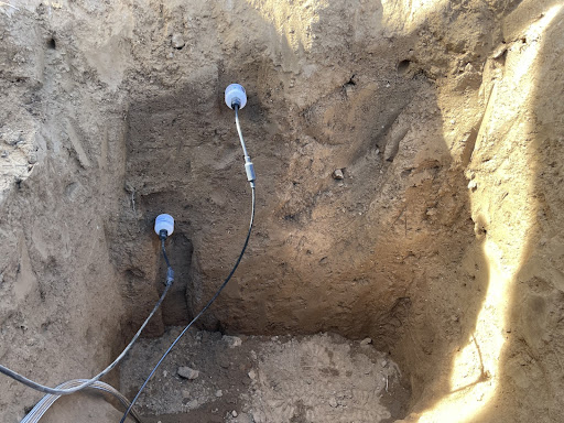
At all Surface Meteorology sites, sensors are installed on either a 10 foot tall tripod with an 11.5 ft base diameter, on a 10 ft tall post installed with concrete, or on a Rohn tower approximately 20 feet tall installed with concrete. Photographs depicting the set up of our Surface Meteorology stations as well as plots of current data can be found below.

We would like to acknowledge our sponsors as well as our partners and collaborators that supported these instruments and allowed the deployment of these stations on their property. For more information about CW3E’s surface observations sponsors and collaborators, please see the bottom of the page.
Email alerts for extreme precipitation within the Yuba and Feather River watersheds are available for the CW3E deployed stations. For more information and to sign up for these alerts click here. An alert for CW3E stations and SNOTELS in and near the Upper Yampa watershed is also available. For more information and to sign up for these alerts click here.
An archive of CW3E collected surface meteorological and stream data in the Russian River watershed is available at https://doi.org/10.6075/J0SX6DDH.
CW3E data is also available on CDEC, MesoWest and NOAA’S PSL.
The plots here represent raw data from the station and have not undergone any quality control. Plots are updated once per hour. Please direct any questions and requests for past and/or QC’d data to cw3e-fieldwork-g@ucsd.edu.
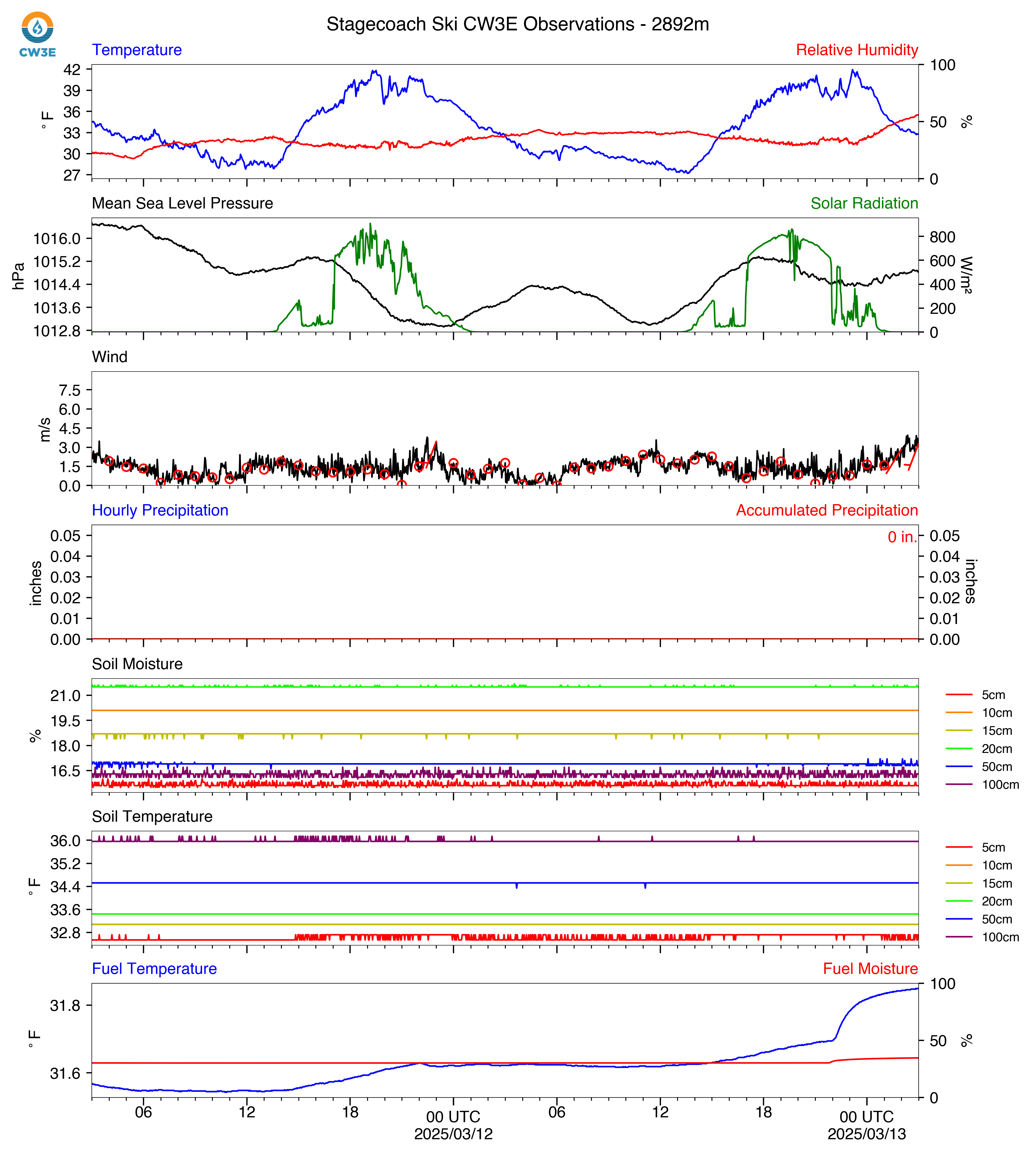
Plot description: Surface meteorological and soil data observed at the location highlighted in the map. Top panel shows temperature (°F; blue line) and relative humidity (percentage; red line), second panel shows mean sea level pressure (hPa; black line) and solar radiation (W/m2; green line), third panel shows wind speed (line; m/s) and direction (vectors), fourth panel shows hourly precipitation (inches; blue bars) and accumulated precipitation during the period shown (inches; red line), fifth panel shows the soil moisture (fraction) at various depths (color denoted by legend on right), and the bottom panel shows the soil temperature (°F) at the same depths as soil moisture. Click the following links for an archive of raw data or images. Snow depth plots should be interpreted with caution. The measurements are inherently noisy (Ryan et al. 2008) and, at certain times of year, the data may be impacted by vegetation growth close to the sensor. Data displayed here are provisional and will be quality controlled at the end of the snowmelt season.
|
 |

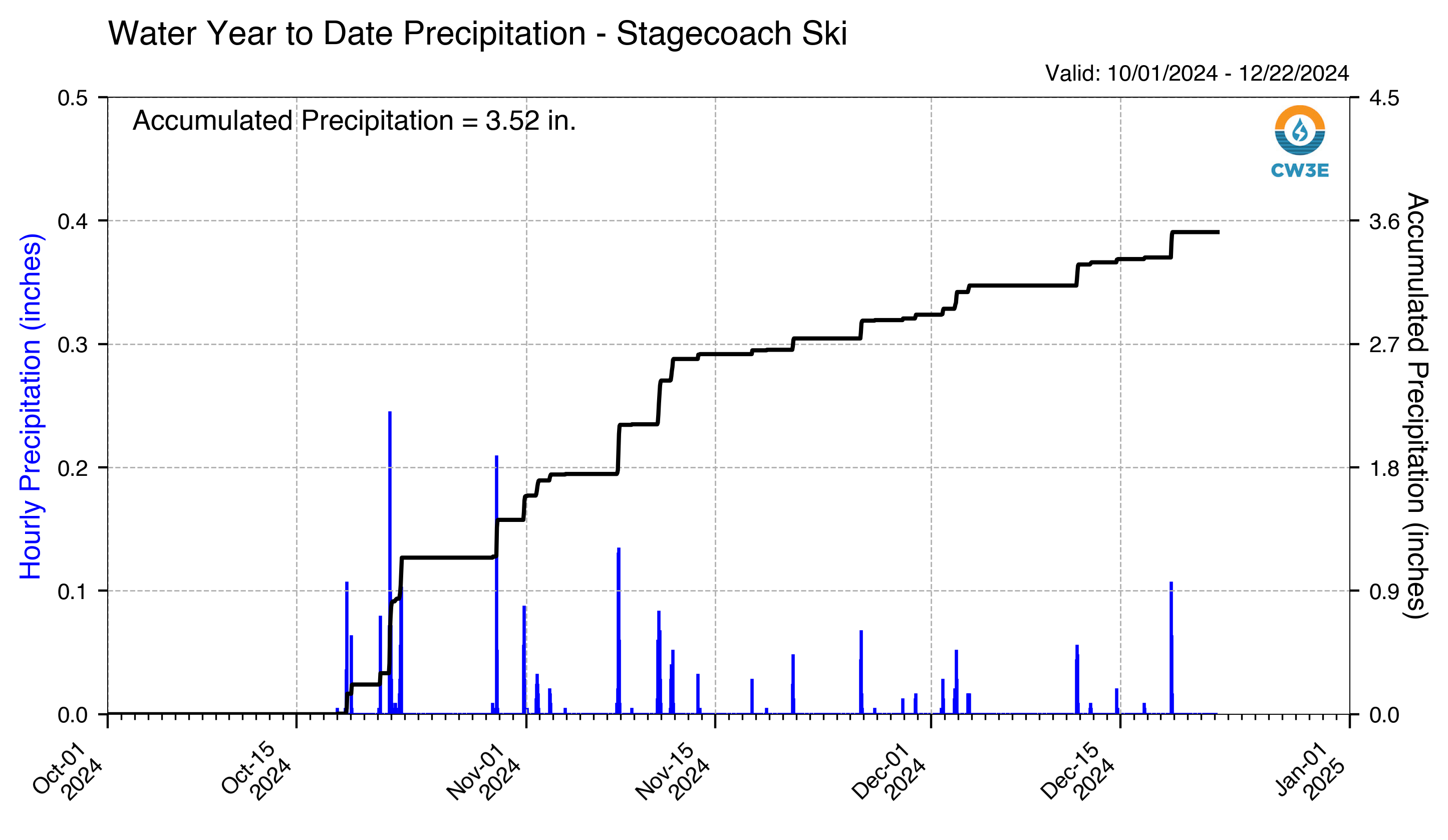
Plot description: Accumulated precipitation (mm on left axis, inches on right axis) measured at the above the locations during the current water year (1 October – current day).
 |
 |
Our sponsors and collaborators
We would like to acknowledge our sponsors as well as our partners and collaborators that supported these instruments and allowed the deployment of these stations on their property.
CW3E is grateful to participate in the California Cooperative Snow Survey Data Acquisition Round Table (DART). The purpose of the DART is to create an open forum to discuss data acquisition experiences, knowledge and recommendations, and to build consensus around professional instrumentation and measurement standards. More information can be found here at the Central Sierra Snow Lab website (choose “CCSS DART” on the top line menu).
In support of Lake Mendocino Forecast Informed Reservoir Operations (FIRO), CW3E has been sponsored by US Army Corps of Engineers (USACE) Engineering and Development Center (ERDC) to operate several meteorological stations in the upper Russian River watershed in northern California in partnership with NOAA, Sonoma Water, UC Davis Bodega Marine Lab, Bureau of Land Management, Potter Valley Fire Department and local landowners.
Multiple meteorological stations have been installed in the Yuba-Feather watershed in northern California as part of the ongoing efforts of Yuba-Feather FIRO, sponsored by Yuba Water Agency, CA Department of Water Resources, and USACE, with close collaboration with NOAA, the Feather River College, San Francisco State University, California Nevada River Forecast Center, Browns Valley School, US Forest Service, Sierra Pacific Industries, and other local landowners.
In the Santa Ana watershed of southern California, efforts are underway to expand the current network in support of Prado FIRO, sponsored by USACE and in partnership with NOAA, U.S. Army Engineer Research and Development Center, and Orange County Water District.
In the Duwamish/Green River watershed in Washington, stations were installed in support of FIRO at Howard Hanson Dam, sponsored by Tacoma Water, and in partnership with the U.S. Army Corps of Engineers.
CW3E was sponsored by NOAA’s Office of Weather and Air Quality to install meteorological stations in the Tuolumne watersheds to improve observations of high impact hydrometeorological events in the Sierra Nevada mountains of California. Ongoing maintenance of these sites and others that will be telemetered in the coming months, and installation of a new site in the Merced watershed is supported by the Department of Water Resources as part of CW3E’s Atmospheric River Program. These sites were made possible with help from our partners at Hetch Hetchy Water & Power, San Francisco Public Utilities Commission, National Parks Service and Portland State University.
As part of ongoing efforts to develop the Yampa Basin Soil Moisture Network in northwestern Colorado, sponsored by the Upper Yampa Water Conservancy District, CW3E, in partnership with Colorado Mountain College, Yampa Valley Sustainability Council, the National Resource Conservation Service and private landowners, has installed one meteorological station with plans to further expand the network. This network expansion, for eight more stations in the coming years, is sponsored by the Colorado Water Conservation Board, the Colorado River District, and the Upper Yampa Water Conservancy District.
In the Green River watershed in Washington, stations were installed in support of FIRO at Howard Hanson Dam, sponsored by Tacoma Water, and in partnership with the U.S. Army Corps of Engineers.
The products are provided “as is” and are intended for research purposes only (disclaimer). All products on this page are considered experimental.