Skip to content
  • About
    • Overview
    • CW3E Strategic Plan
    • Background
    • Themes
    • People
    • Partners
    • Programs
    • Equity, Diversity, & Inclusion (EDI)
    • Water Affiliates Group
    • What is an Atmospheric River?
    • WY 2023 AR Family Story Map
  • Observations
    • Satellite
    • Precipitation
    • Stream Flow
    • AR Observatories
    • CW3E Observations
      • Surface Meteorology
      • MicroRain Radars
      • Disdrometers
      • Wind Profilers
      • Radiosondes
    • AQPI
  • AR Reconnaissance
    • Overview
    • Data
    • Sponsors & Partners
    • Related Info
  • Forecasts
    • AR, IWV, and IVT Forecasts
    • AR Scale Forecasts
    • Deterministic Models
      • IVT and IWV
      • 250-hPa Winds
      • 500-hPa Vorticity
      • 850-hPa Temperature
      • Precipitation
    • Interactive Maps
    • Precipitation Forecasts
    • Subseasonal to Seasonal Forecasts
    • West-WRF
      • Deterministic
      • Ensemble
    • Forecast Verification
      • AR Landfall Verification
      • QPF Verification
  • FIRO
    • Overview
    • Process
    • News
    • Projects
      • FIRO Russian River
      • Prado Dam
      • Yuba-Feather
      • Seven Oaks Dam
      • Howard Hanson Dam
    • FIRO Colloquium
    • FIRO Workshop
  • News & Publications
    • News
    • Publications
      • Peer Reviewed Articles
      • Book Chapters
      • Public Reports
    • Bibliography of AR-Focused Publications
    • Meetings
    • International Atmospheric Rivers Conference
    • Summer Internship Program
  • CW3E North

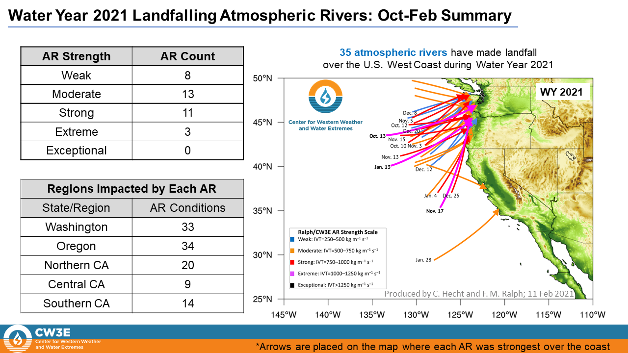
Distribution of Landfalling Atmospheric Rivers over the U.S. West Coast During Water Year 2021: Quarter Year Summary

February 11, 2021

For a pdf of this information click here.


Link to a post-event summary of the 26 to 29 January 2021 AR here
 

Analysis by Chad Hecht, Jason Cordeira, Julie Kalansky, & F. Martin Ralph. This analysis is considered experimental. For questions regarding the data or methodology please contact Chad Hecht


Entry posted in: Atmospheric Rivers, Drought, Extreme Events

Previous post: Estimating Benefits of Forecast-Informed Reservoir Operations (FIRO): Lake Mendocino Case-Study and Transferable Decision Support Tool Next post: CW3E AR Update: 12 February 2021 Outlook

Recent Posts

  • Breaking Ground to Expand Climate Monitoring Network in Upper Yampa River Basin
  • CW3E AR Update: 28 November 2023 Outlook
  • CW3E Welcomes Lu Su
  • CW3E Publication Notice: A long short-term memory neural network-based error estimator for three-dimensional dynamically adaptive mesh generation
  • CW3E Publication Notice: Mesoscale and Synoptic Scale Analysis of Narrow Cold Frontal Rainband During a Landfalling Atmospheric River in California During January 2021

Categories

  • AR Recon
  • Atmospheric Rivers
  • CW3E AR Updates
  • CW3E Partners
  • Data
  • Drought
  • Dust
  • Extreme Events
  • FIRO
  • Instrumentation
  • Meetings
  • Missions
  • Outreach
  • People
  • Publications
  • Research
  • S2S Outlooks
  • Uncategorized

F. Martin Ralph, PhD., Director

Center For Western Weather and Water Extremes (CW3E)
Scripps Institution of Oceanography
University of California, San Diego
9500 Gilman Drive
La Jolla, CA 92093
Directions


CW3E Partners

California Department of Water Resources
NOAA National Weather Service
NASA/Jet Propulsion Laboratory
Orange County Water District
Sonoma Water
U.S. Army Corps of Engineers
U.S. Bureau of Reclamation


Search CW3E

Disclaimer

Contact Webmaster

Follow CW3E on Twitter