CW3E Publication Notice
Reinterpreting ENSO’s Role in Modulating Impactful Precipitation Events in California
August 9, 2024
A recent study has shed new light on the seasonal behavior of winter weather patterns that impact California, revealing the intricate ways El Niño and La Niña influence the State’s hydroclimate. This research is described in a new paper entitled “Reinterpreting ENSO’s Role in Modulating Impactful Precipitation Events in California”, which was recently published in Geophysical Research Letters by authors Kristen Guirguis (CW3E), Benjamin Hatchett (NOAA), Alexander Gershunov (CW3E), Mike DeFlorio (CW3E), Rachel Clemesha (UCSD), Tyler Brandt (CW3E), Kayden Haleakala (CW3E), Christopher Castellano (CW3E), Rosa Luna Niño (CW3E), Alexander Tardy (NWS), Michael Anderson (DWR), and Marty Ralph (CW3E). This research was sponsored by the California Department of Water Resources Atmospheric River Program, and supports CW3E’S 2019-2024 Strategic Plan by seeking to improve subseasonal-to-seasonal (S2S) predictability of extreme hydroclimate variables over the western U.S. region.
This research was motivated by recent seasonal forecast challenges in which winter precipitation in California deviated substantially from the seasonal forecasts issued 1-3 months in advance. Despite predictions of dry winters due to La Niña, California experienced unexpectedly wet conditions in both 2017 and 2023. Conversely, the strong El Niño of 2016 was expected to bring wet weather, but the season turned out to be normal-to-dry across the state.
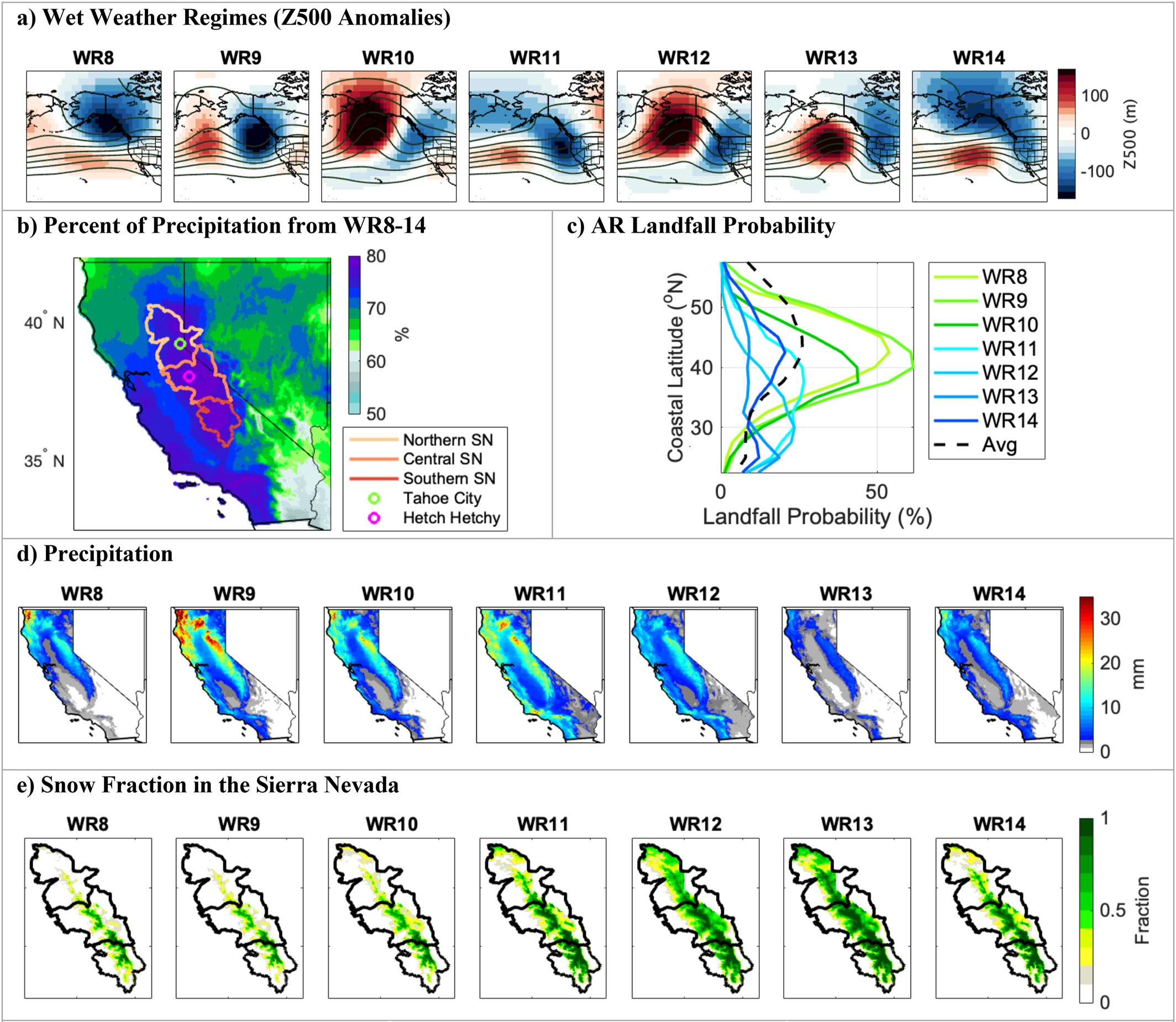
Figure 1. (a) The wet weather regimes (WR8-14) responsible for most of California’s precipitation, which are a subset of sixteen weather regimes studied, shown as 500 mb geopotential height anomalies. (b) Percent of historical (1979-2023) precipitation that fell during WR8-14 with outlines of the Northern, Central, and Southern Sierra Nevada and locations of Tahoe City and Hetch Hetchy Coop stations. (c) AR landfall probability at different coastal latitudes for WR8-14. (d-e) Average daily precipitation and snow fraction from WR8-14.
In this new article, we delved into historical data to first examine how recurring atmospheric weather patterns influence California precipitation and Sierra Nevada snowpack (Figure 1). We then investigated if/how El Niño Southern Oscillation (ENSO) interacts with these recurring weather patterns to produce the known ENSO-precipitation teleconnection pattern (Figure 2). Our findings indicate that while ENSO significantly affects the characteristics of storms once they reach California—making El Niño storms generally wetter in coastal southern California and the Desert Southwest—it does not strongly influence how often these weather patterns occur in a season. This complexity makes seasonal precipitation forecasts particularly challenging.
The study highlights that the frequency of certain weather patterns not tied to ENSO played a crucial role in the unexpected rainfall of 2017, the heavy snowfall of 2023, and the drier-than-expected winter of 2016. This new understanding of how ENSO influences these hydrologically critical weather patterns provides valuable insight that could help to inform future seasonal forecasts. It emphasizes that while ENSO has a minimal impact on the frequency of impactful storm types, it does alter the precipitation characteristics of these storms, offering operational and scientific context for meteorologists and water managers.
This research links daily weather with seasonal climate and underscores the need for more nuanced and comprehensive approaches to seasonal weather forecasting in California, aiming to better prepare for the diverse and often unpredictable impacts of El Niño and La Niña in future California winters.
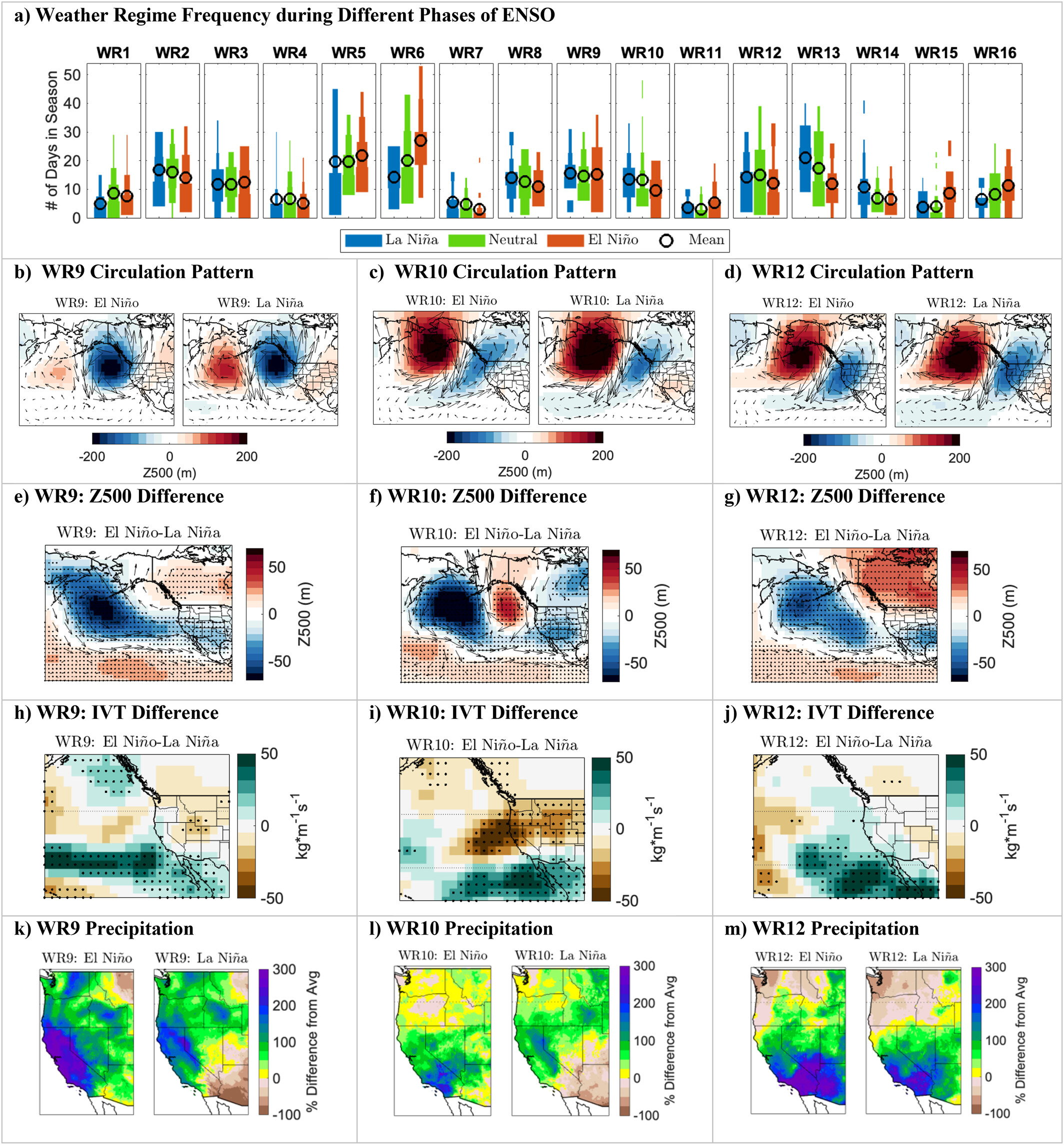
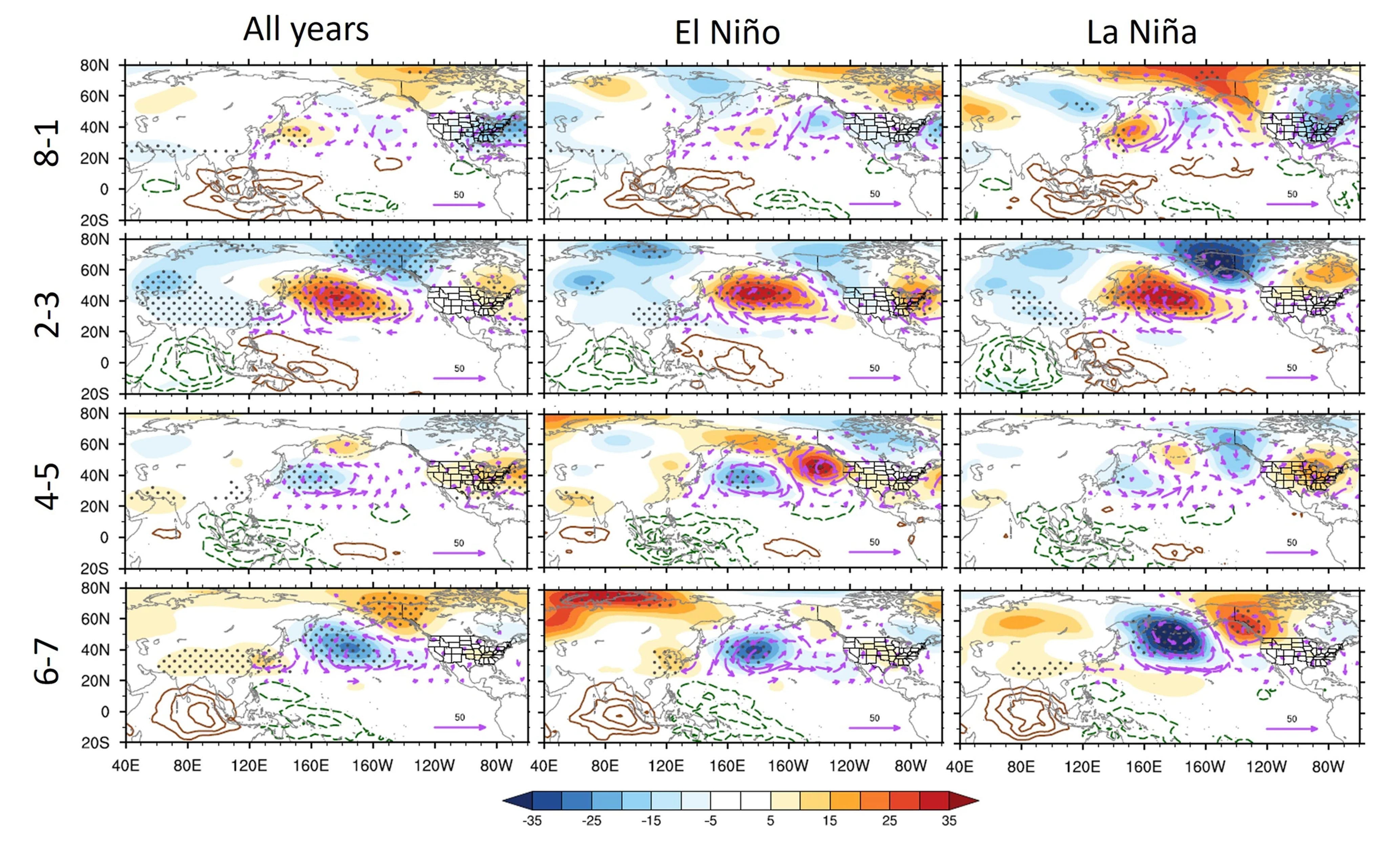
Figure 2. (a) Seasonal weather regime frequency (y-axis) conditional on ENSO phase (color scale), shown as a hybrid of a boxplot and histogram where the bar width represents the proportion of data in a bin and the “o” denotes the mean. (b-d) 500 mb geopotential height anomaly patterns for WR9, WR10, and WR12 during El Niño (left) and La Niña (right). (e-g) Difference in Z500 fields shown as El Niño minus La Niña. (h-j) Difference in IVT shown as El Niño minus La Niña for WR9, WR10, and WR12. (k-m) Precipitation anomalies for WR9, WR10, WR12 during El Niño (left) and La Niña (right). Stippling in e-g and h-j indicates statistically significant differences (5% level, student’s t-test).
Guirguis, K., Hatchett, B., Gershunov, A., DeFlorio, M., Clemesha, R., Brandt, W. T., Haleakala, K., Castellano, C. Niño, R. L., Tardy, A., Anderson, M., & Ralph, F. M. (2024). Reinterpreting ENSO’s role in modulating impactful precipitation events in California. Geophysical Research Letters 51, e2024GL110326. https://doi.org/10.1029/2024GL110326