CW3E Publication Notice
Mesoscale and Synoptic Scale Analysis of Narrow Cold Frontal Rainband During a Landfalling Atmospheric River in California During January 2021
November 20, 2023
A new paper titled “Mesoscale and Synoptic Scale Analysis of Narrow Cold Frontal Rainband During a Landfalling Atmospheric River in California During January 2021” by a group of CW3E scientists (Jerry Zou, Jay Cordeira, Sam Bartlett, Brian Kawzenuk, Shawn Roj, Chris Castellano, Chad Hecht, and Marty Ralph) was recently published in the American Geophysical Union’s Journal of Geophysical Research: Atmospheres. On 27 January 2021, an atmospheric river (AR) associated with an intense surface cyclone made landfall over coastal northern California. The landfalling AR featured both synoptic-scale and mesoscale precipitation processes related to quasi-geostrophic (QG) forcing for ascent, upslope flow, a narrow cold-frontal rainband (NCFR), potential instability and a moist absolutely unstable layer (MAUL), and likely the seeder-feeder mechanism. This particular case involved a distinctive combination of short-duration, high-impact rainfall, and moderate stratiform precipitation along the coastal regions of California, attributed to the stalling and pivoting of the NCFR. Additionally, it offers valuable insights into non-typical orographic forcing of extreme precipitation, serving as a useful addition to prior studies. This work supports the AR Research and
Applications and Modeling Capabilities for the Western United States Priority Areas in CW3E’s 2019–2024 Strategic Plan.
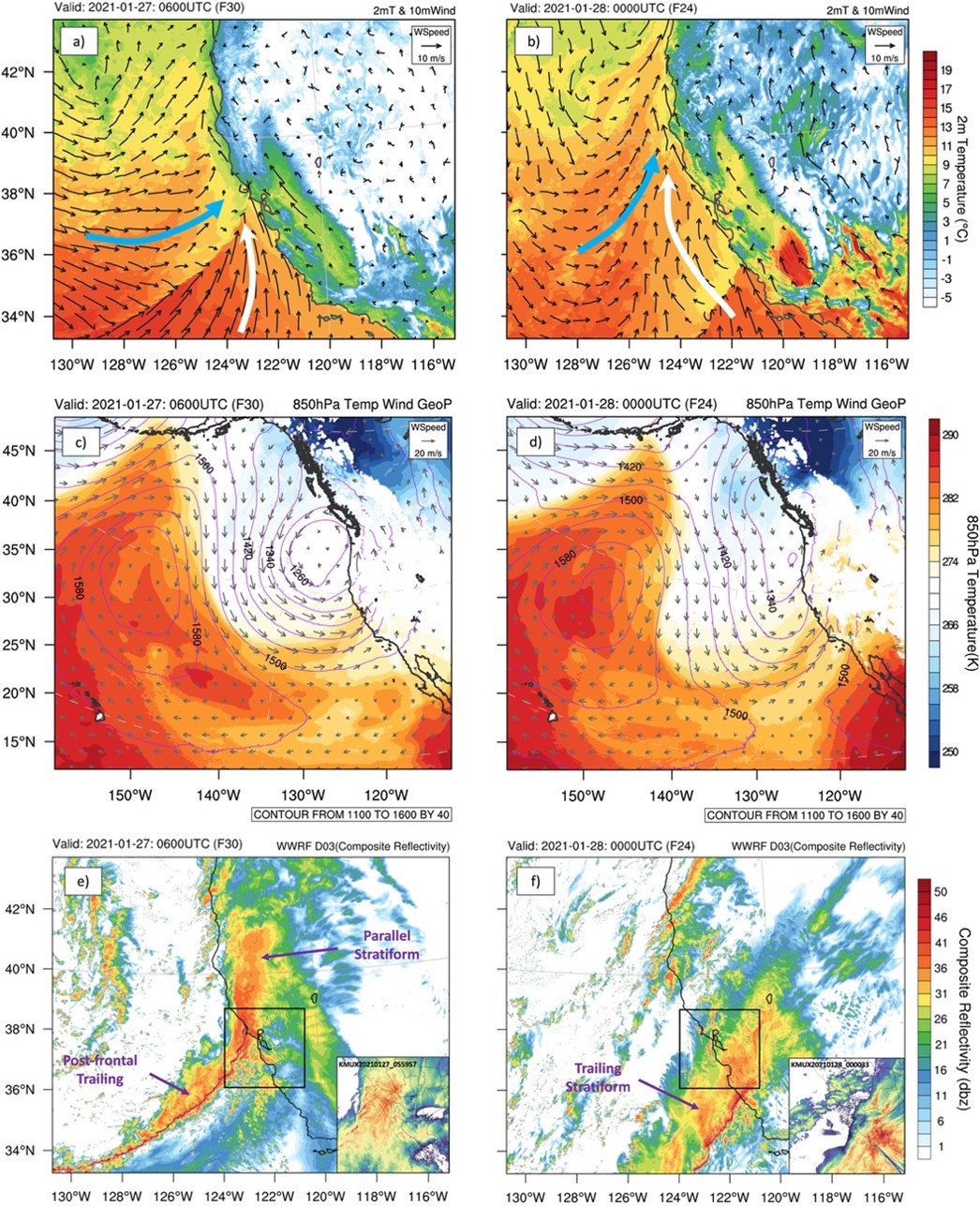
Our study employs high-resolution West-WRF simulations to accurately characterize the gap and core structure of the NCFR, offering reliable precipitation estimations that address the limitations of radar and satellite observations. The NCFR was supported by robust synoptic-scale QG forcing for ascent and frontogenesis. It propagated southward from Cape Mendocino to Big Sur in 12 hr before stalling and rotating counter-clockwise in central/southern California due to upstream Rossby wave breaking and an amplifying upper-tropospheric trough. With the lower to middle tropospheric flow backed considerably to the south-southwest over the NCFR, the increase of the vertical wind shear caused the transition from parallel to trailing stratiform precipitation. The stall and pivot of the AR and NCFR led to intense rainfall with a 2-day precipitation accumulation greater than 300 mm over central California. In addition, under the potential instability and frontogenesis, a MAUL between 850 and 700 hPa was captured at the leading edge of the NCFR, which indicated slantwise deep layer lifting and high precipitation efficiency.
The results of this study complement previous studies on AR-related NCFR events in California by Cannon et al. (2018, 2020) and reaffirm the importance of developing West-WRF as a cutting-edge high-resolution numerical weather prediction system with a focus on extreme precipitation and related natural hazards. High-resolution simulations offer improved insights into the physical mechanisms driving efficient air lifting, leading to intense precipitation. Furthermore, we highlight the necessity for improved observational coverage along the U.S. West Coast to capture the shallow convective structure in NCFRs, essential for monitoring and forecasting extreme precipitation events.
Figure 1: (Figure 4 from Zou et al. 2023) Parallel stratiform (PS) precipitation and trailing stratiform (TS) precipitation during the 2021 January narrow cold-frontal rain event. (a, b) 2-m temperature and 10-m wind from West-WWRF D03 (1 km) at 0600 UTC 27 January (PS) and 0000 UTC 28 January (TS), respectively. Blue arrow represents cold air advection, and white arrow represents warm air advection. (c, d) 850-hPa geopotential height (contour line), temperature (contour fill), and wind field (vector) from West-WRF D01 (9 km) at 0600 UTC 27 January and 0000 UTC 28 January, respectively. (e, f) Composite reflectivity from West-WRF D03 (1 km) at 0600 UTC 27 January and 0000 UTC 28 January, respectively. The subplot at the right corner in (c, d) are NEXRAD observations at San Francisco station (KMUX). Black boxes in (c, d) represent the domain of the subplots.
Zou, X., Cordeira, J. M., Bartlett, S. M., Kawzenuk, B., Roj, S., Castellano, C., Hecht, C., & Ralph, F. M. (2023). Mesoscale and synoptic scale analysis of narrow cold frontal rainband during a landfalling atmospheric river in California during January 2021. Journal of Geophysical Research: Atmospheres, 128(20), e2023JD039426. https://doi.org/10.1029/2023JD039426

