CW3E Publication Notice: Extending the CW3E Atmospheric River Scale to the Polar Regions

CW3E Publication Notice

Extending the CW3E Atmospheric River Scale to the Polar Regions

November 25, 2024

Atmospheric rivers (ARs) are the primary mechanism for transporting water vapor from low latitudes to polar regions. They play a critical role in regional climate and extreme weather events in polar regions (e.g., Figure 1), exerting an important influence on the polar cryosphere. With the rapidly growing interest in polar ARs during the past decade, it is imperative to establish an objective framework quantifying the strength and impact of these ARs for both scientific research and practical applications.

The AR scale developed by Ralph et al. (2019) has been widely used in scientific research, weather forecasts, and media reports. While the AR scale was developed based on the climatology of water vapor transport at middle latitudes, it is insufficient for polar regions where temperatures and moisture content are significantly lower. A new paper entitled “Extending the Center for Western Weather and Water Extremes (CW3E) Atmospheric River Scale to the Polar Regions” was recently published in The Cryosphere. It is led by CW3E researcher Zhenhai Zhang and co-authored by Martin Ralph (CW3E), Xun Zou (CW3E), Brian Kawzenuk (CW3E), Minghua Zheng (CW3E), Irina Gorodetskaya (University of Porto, Portugal), Penny Rowe (North-West Research Associates), and David H. Bromwich (The Ohio State University). This paper introduced an extended version of the AR scale tuned to polar regions (Figure 2) based on the climatology there. Three new ranks specific for polar regions (AR P1, AR P2, and AR P3) with the minimum integrated water vapor transport (IVT) thresholds of 100, 150, and 200 kg m-1 s-1 are added to the standard AR scale (AR1 – AR5) to capture low-IVT ARs in both the Arctic and Antarctic. The polar AR scale also uses the same approach as the AR scale to promote or demote by one rank based on the duration of the AR at that location being less than 24 hours or longer than 48 hours.

Using the polar AR scale, this paper examined AR frequency, seasonality, trends, and associated precipitation and surface melt over Antarctica and Greenland. ARs contribute about one-third of the total precipitation amount over the coastal regions of Antarctica and Greenland. Weak and moderate ARs (AR P1 – AR2) are responsible for the majority of the AR-related precipitation amount along the Antarctic and Greenland coasts due to their relatively high frequency. Meanwhile, the strong and extreme ARs (AR3 and AR4) are usually associated with extreme precipitation, although their frequency is relatively low. In addition, ARs trigger 23% and 26% surface melting on average in Antarctica and Greenland, respectively, and around one-third of the surface melting over the coastal regions due to the relatively higher frequency and strength of the ARs over the coasts. With these high impacts, the frequency of landfalling ARs has shown significant increasing trends over the Antarctic Peninsula and East Greenland coasts in the last few decades, indicating the even greater importance of ARs in the polar regions, which are acknowledged to be vulnerable to a changing climate.

Based on the polar AR scale, we developed the CW3E Antarctica AR Scale Forecast tools using the NCEP Global Ensemble Forecast System (GEFS). These tools were extensively used in guiding radiosonde launches during the targeted observing periods (TOPs) in the Year of Polar Prediction in the Southern Hemisphere project (YOPP-SH), demonstrating reliability in guiding radiosonde launches from 24 stations during TOPs (Bromwich et al., 2024). Figure 3 shows an example of the CW3E Antarctica AR Scale Forecast tools. Our recently funded project by the National Science Foundation (NSF) will enhance the CW3E Antarctica AR Scale Forecast tools by incorporating real-time forecast data from the Antarctic Weather Research & Forecasting Model (WRF) Mesoscale Prediction System (AMPS) in the National Center for Atmospheric Research (NCAR), supporting both research and operational objectives. Additionally, we will also develop similar polar AR scale forecast products for Greenland in the future.

Overall, the CW3E polar AR scale provides an objective and concise description of the strength of AR events at the locations of interest based on their intensity and duration in the Antarctic and Arctic regions. It has the potential to enhance communication regarding ARs across observation, research, and forecast communities in polar regions.

Figure 1. An extreme landfalling AR over East Antarctica during 16–18 March 2022 based on ERA5 reanalysis. (a) Three-day time-integrated IVT (T-IVT) during 16–18 March 2022 as a percentage of normal (mean 3-day T-IVT during 1980-2021); the sub-panel at the top left shows the IVT (colors start from 200 kg m-1 s-1 with an increment of 100 kg m-1 s-1) at 00 UTC on 17 March. (b) Time series of averaged 3-day T-IVT within the blue box in panel (a) for 2022 (red), 1980-2021 (black), and climatological mean (1980-2021, green). (c) Temperature anomaly on 18 March 2022 based on ERA5 reanalysis. (d) Time series of 3 hourly observed temperatures at Dome C station (blue dot in panel a and c) for 2022 (red), 1996-2021 and 2023 (gray), and climatological mean (1996-2023 mean, blue). (Figure 1 in Zhang et al., 2024)

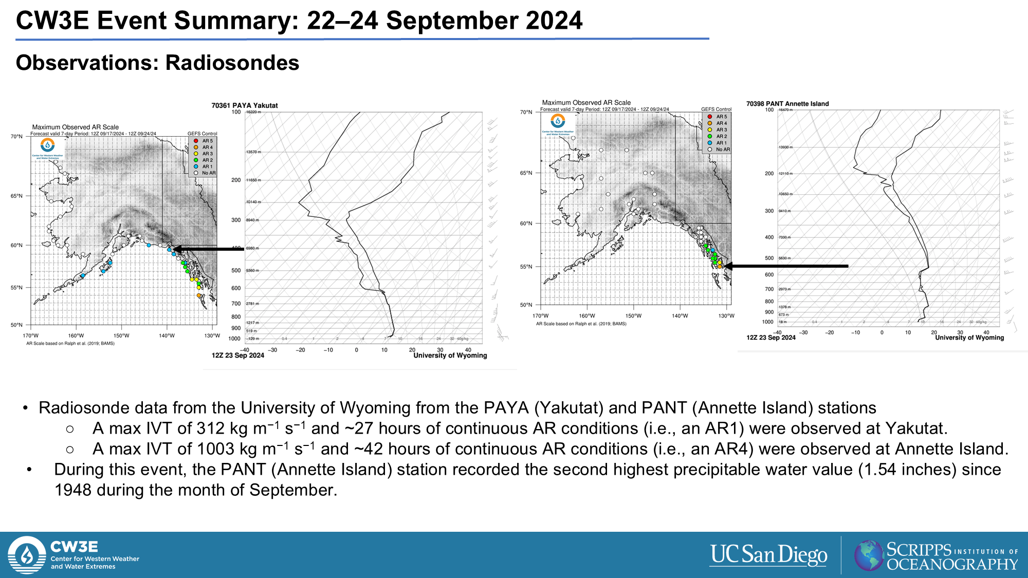
Figure 2. An extended AR scale for polar regions that categorizes AR events based on the duration of AR conditions (IVT ≥ 100 kg m-1 s-1) and the maximum IVT in the duration at a specific location. This scale includes ranks (AR P1, AR P2, and AR P3) designed specifically for ARs in polar regions. (Figure 5 in Zhang et al., 2024)

Figure 3. CW3E AR scale ensemble diagnostic forecast tool for 70°S, 5°E from the GEFS. initialized at 06Z 04/15/2022. Dots along the Antarctic coast indicate locations where information such as that shown in other panels can be provided; here other panels refer to the larger point at 70°S, 5°E).(a) Maximum Polar AR scale forecast over the next seven days along the Antarctic Coast (colored dots), enlarged dot represents the location shown in panels b-d. (b) Seven day forecast of IVT from each ensemble member (thin gray lines), the ensemble mean (green line), control member (black line) and +/- 1 standard deviation from the ensemble mean (red and blue lines and gray shading). Color shading represents the timing of the Polar AR scale from the control member. (c) Forecasted probability of each Polar AR scale ranking as a function of lead time based on the number of ensemble members predicting an AR. (d) Forecasted Polar AR scale timing and ranking from each ensemble member, text values represent the maximum IVT magnitude and timing during a forecasted AR. (Figure 14 in Zhang et al., 2024)

Zhang, Z., Ralph, F. M., Zou, X., Kawzenuk, B., Zheng, M., Gorodetskaya, I. V, … & Bromwich, D. H. (2024). Extending the Center for Western Weather and Water Extremes (CW3E) Atmospheric River Scale to the Polar Regions. The Cryosphere, 18(11), 5239–5258. https://doi.org/10.5194/tc-18-5239-2024

Ralph, F. M., Rutz, J. J., Cordeira, J. M., Dettinger, M., Anderson, M., Reynolds, D., … & Smallcomb, C. (2019). A scale to characterize the strength and impacts of atmospheric rivers. Bulletin of the American Meteorological Society, 100(2), 269-289. https://doi.org/10.1175/BAMS-D-18-0023.1

Bromwich, D. H., Gorodetskaya, I. V., Carpentier, S., Alexander, S., Bazile, E., Heinrich, V. J., … & Zou, X. (2024). Winter Targeted Observing Periods during the Year of Polar Prediction in the Southern Hemisphere (YOPP-SH). Bulletin of the American Meteorological Society, 105(9), E1662-E1684. https://doi.org/10.1175/BAMS-D-22-0249.1

CW3E Members Attend the 2024 Atmospheric River Reconnaissance Workshop at NOAA’s Center for Weather and Climate Prediction in College Park, MD

CW3E Members Attend the 2024 Atmospheric River Reconnaissance Workshop at NOAA’s Center for Weather and Climate Prediction in College Park, MD

November 18, 2024

The 2024 Atmospheric River Reconnaissance (AR Recon) Workshop took place at the NOAA Center for Weather and Climate Prediction in College Park, MD, from October 22-24, 2024. This event brought together AR Recon participants and experts to discuss recent advancements, coordination of future efforts, and methods to enhance collaborative research on atmospheric rivers.

The three-day event featured Ken Graham, NWS director, who delivered a keynote address highlighting the importance of atmospheric river research, observational data, and the collaborative efforts required to advance this field. The workshop included participation from various partners, including Lagrangian Drifter Laboratory, NAWDIC-AR Recon, and USACE FIRO partners, emphasizing the collaborative nature of the event, and showcased AR Recon’s recent endorsement from the World Weather Research Programme (WWRP)
.

Key Highlights:

  • Advancements in Atmospheric River Research: The three-day workshop featured presentations, panel discussions, and poster sessions featuring the latest findings in atmospheric river studies, including new methodologies and technologies.
  • Data Collection Techniques: Participants discussed innovations in data collection, such as the use of Global Sounding Balloons (Windborne Systems) and Airborne Radio Occultation (ARO, Scripps PI Jennifer Haase) to improve atmospheric observations.
  • Collaborative Efforts: Emphasis was placed on the Research And Operations Partnership (RAOP) approach, which aims to improve predictions of land-falling atmospheric rivers in the U.S. through enhanced collaboration between research and operational communities.
  • Expansion of Operations: The workshop highlighted the geographic expansion of AR Recon operations, including new flight campaigns out of Guam in early 2024, and plans for Pacific (NE and NW) and Atlantic reconnaissance missions.
  • Panel Discussions: Each panel discussion focused on different aspects of atmospheric river research, data collection techniques, and collaborative efforts to improve weather forecasting and water management.

Workshop Goals:

  • Impact Assessment: Documenting the impacts of AR Recon data on weather forecasting and water management.
  • Operational Strategies: Reviewing and refining strategies for operational sampling, data collection, and dissemination.
  • Future Research Directions: Guiding future research efforts, including coordinated data impact studies and exploration of campaign expansion.

Agenda Highlights:

  • Day 1: Opening remarks, presentations on recent advancements in atmospheric river research, and sessions on data collection techniques.
  • Day 2: Workshops on data assimilation and metric development, followed by breakout sessions for RAOP working groups.
  • Day 3: Presentations on the impact assessment of AR Recon data, discussions on future research directions, and closing sessions focusing on operational strategies and collaborative efforts.

CW3E Publication Notice: Investigating the atmospheric conditions associated with impactful shallow landslides in California (USA)

CW3E Publication Notice

Investigating the atmospheric conditions associated with impactful shallow landslides in California (USA)

November 05, 2024

“Investigating the atmospheric conditions associated with impactful shallow landslides in California (USA)” was recently published in Earth Interactions. This work was a collaboration among scientists from CW3E, the California Geological Survey, and the U.S. Geological Survey. The project was supported by the U.S. Geological Survey Landslide Hazards Program and the California Department of Water Resources Atmospheric River Program.

Landslides pose a threat to life, property, and infrastructure in mountainous areas of California. Previous work has focused on antecedent and within-storm rainfall triggering thresholds. However, site-specific rainfall information is not always available and there is uncertainty in these thresholds. This work explores whether there are common meteorological characteristics associated with landslide events that could aid in their prediction.

Previous research has noted the connection between atmospheric rivers and landslides. This analysis expands on previous work by exploring numerous atmospheric characteristics of landslide-producing storms in detail, including variables associated with ARs. The investigation evaluates 18 widespread shallow landslide events occurring in 13 unique storms where landslide timing could be constrained to a 6-hour window. Working with well-constrained landslide timing allows for evaluation of synoptic-to-mesoscale atmospheric characteristics associated with each event that would not be possible if longer time windows were used.

Figure 1. As in Figure 2 from Oakley et al. 2024; Location and year of landslide events in this analysis.

Results indicate that landslides occur under a broad range of synoptic patterns across the state. ARs were more prevalent in landslide producing storms in northern California than southern California, and the strength of AR conditions in landslide-producing storms was generally higher in northern California. Two-thirds of the 18 landslide events had Integrated Water Vapor Transport (IVT) exceeding the 99th percentile for the cool season and roughly 40% the events had Integrated Water Vapor (IWV) exceeding the 99th percentile. Nearly all events occurred with the upper-level jet stream overhead, and often associated with areas of the jet favorable for strong upward vertical motions. All 18 events were associated with Convective Available Potential Energy (CAPE) greater than 80th percentile for the season at the landslide location, with 12 greater than 95th percentile. High intensity rainfall features with radar reflectivity >50 dBZ were present in seven of 18 events. All but one landslide event had above normal Water Year (October 1) to-date precipitation, and that event featured a very intense, slow moving convective band, suggesting that the mesoscale characteristics of storms (e.g., embedded convection) may overcome below-average antecedent precipitation conditions and trigger landsliding.

Table 1. As in Table 2 from Oakley et al. 2024; Rainfall and moisture variable characteristics for landslide events. The “Event” column provides the event name (See Table 1 in Oakley et al. 2024). Superscripts in the “Event” column indicate landslide events that happened in different locations in the same storm. The “% Avg. WYTD Precip.” column provides the percent of water year to-date average precipitation prior to the landslide event. The “TECA-BARD AR” column provides the percent likelihood of detection of an AR object based on the TECA-BARD detection algorithm for a 6-hour period (24-hour period). Where no (24-hour) value is provided, the 24-hour value was equal to 6 hours. The “AR Scale (Coast)” column provides the AR Scale value at the coastal landfall location west of the landslide. A range is provided where the coastal scale is ambiguous. The “AR Scale (Loc.)” column provides the AR Scale value at the landslide location. For both AR Scale columns, “NA” indicates the location did not meet AR Scale criteria. The “IVT” and “IVT Pctile” columns provide the IVT value and percentile rank of the IVT value at the landslide location. The “IWV” and “IWV Pctile” columns provide the IWV value and the percentile rank of the IWV value at the landslide location.

Landslide producing storms occurred in all phases of the El Niño-Southern Oscillation; of the 13 storm events, six occurred during El Niño conditions, five during La Niña, and two during neutral conditions. However, five of seven storm events producing landslides in southern California occurred under El Niño condition, suggesting a stronger relationship in that region.

While some common characteristics were identified across landslide-producing storms, these storms share many characteristics of other hydrologically impactful storms that may or may not produce landslides. Further research is needed to discern between antecedent and in-storm characteristics associated with landslide activity or the lack thereof.

This work addresses the CW3E priority area of Atmospheric Rivers Research and Applications, as it explores atmospheric conditions associated with events including atmospheric rivers and their relation to landsliding to improve decision making associated with these hazards. It also addresses the priority area of Monitoring and Projections of Climate Variability and Change. This work provides new insights from research on historical extreme events to enhance conceptual understanding of these events. With an interdisciplinary team of geologists, engineers, and atmospheric scientists from state and federal agencies and university, this research displays the CW3E core value of Collaboration.

Oakley, N. S., Perkins, J. P., Bartlett, S. M., Collins, B. D., Comstock, K. H., Brien, D. L., Burgess, W. P., & Corbett, S. C. (2024). Investigating the atmospheric conditions associated with impactful shallow landslides in California (USA). Earth Interactions (Early Online Release) https://doi.org/10.1175/EI-D-24-0003.1

CW3E Presents to the UC San Diego Community Advisory Group

CW3E Presents to the UC San Diego Community Advisory Group

October 29, 2024

The Center for Western Weather and Water Extremes (CW3E) participated in a meeting for the UC San Diego Community Advisory Group (CAG) with Margaret Leinen, Director of Scripps Institution of Oceanography and Morgan Levy, Co-PI of NSF’s Coastlines and Peoples Southern California Heat Hub. The Community Advisory Group includes varied members of the San Diego community to foster a positive and productive relationship with UC San Diego. Communities include La Jolla, University City, Hillcrest and Downtown San Diego, as well as University representatives from the Associated Students (AS), Graduate Student Association (GSA), Staff, Faculty and Chancellor’s Community Advisory Board (CCAB). The Community Advisory Group is formed with a special emphasis on collaborating with the local San Diego community and to provide insights on the various facets and functions of the university, including the positive impact that UC San Diego has at the local and regional levels.

After Margaret gave an overview of current research at Scripps Institution of Oceanography, CW3E’s Deanna Nash gave a short presentation on the historical atmospheric river event that impacted San Diego on January 22, 2024. The event on January 22, 2024 produced 2–4 inches of precipitation in parts of San Diego County, contributing 25–50% of normal annual precipitation in a 24-hour period. The intense rainfall resulted in widespread flooding across San Diego, prompting several swiftwater rescues. Additionally, Deanna shared how CW3E’s AR Reconnaissance is improving atmospheric river and precipitation forecasts and how Forecast Informed Reservoir Operations (FIRO) are improving drought and flood resilience in California.

CW3E Publication Notice: On the use of hindcast skill for merging NMME seasonal forecasts across the western U.S.

CW3E Publication Notice

On the use of hindcast skill for merging NMME seasonal forecasts across the western U.S.

October 17, 2024

A new paper entitled “On the use of hindcast skill for merging NMME seasonal forecasts across the western U.S.” was recently published in Weather and Forecasting by William Scheftic, Xubin Zeng, Michael Brunke, Amir Ouyed and Ellen Sanden from the University of Arizona and Mike DeFlorio from CW3E. This paper completes a series of experiments that test the impact on merged and post-processed seasonal forecasts of temperature and precipitation for hydrologic subbasins across the western U.S. by using different strategies to apply weights to each model from the North American Multi-Model Experiment (NMME). The results from this paper have been used to improve the UA winter forecasts that have been hosted at CW3E for the past three winters, and this effort supports CW3E’S 2019-2024 Strategic Plan by seeking to improve seasonal predictability of extreme hydroclimate variables over the western U.S. region.

This research contributed to our understanding of how effective the past performance of multiple models can be used for seasonal forecasting over the western U.S. as highlighted in Figure 1, where we focus only on precipitation since the results did not differ significantly from similar results obtained with temperature. First (Figure 1a), we show that consistent with past research a simple equal weighted combination of NMME models used in the study outperforms the individual models across all lead months. Second (Figure 1b), using correlation-based metrics for past performance as the weights in combining all NMME models performs better than skill score-based metrics. Third (Figure 1c), the strategy of pooling past performance using multiple months and basins did not have a significant impact on the performance for the multi-model forecast. Finally (Figure 1d), we show that overall, the weighted multi-model forecasts using prior performance did not significantly outperform the equal weighted method, and other methods such as multiple linear regression and random forecast significantly underperformed the equal weighted forecasts. If an offset is added to the prior performance metric that nudges the multi-model merging closer to equal weighting, an optimal weighting may improve over both equal weighting and the original weighted merging. An offset for the weighted multi-model merging is now being used for the UA winter outlooks to further improve these seasonal forecasts.

Figure 1. Median difference of standardized anomaly correlation (SAC) for monthly precipitation forecasts across 500 resampled sets of validation years, all months and HUC4 subbasins according to lead month (x-axis) between each individual model and Equal Weighting (EQ) of six models (a), by prior metric used for merging weights. Prior metrics: Standardized anomaly correlation (SAC), Spearman rank correlation (SpCr), MSE-based skill score (MSSS), ranked probability skill score (CRPSS) (b), by training data pooling strategy used for merging weights. Strategies: no pooling (1mo), 3 month moving window (3mo), 5 month moving window (5mo), all months pooled together (mon), all basins pooled together (bsn), all months and basins pooled together (all) (c), by methods used for merging weights. Methods: correlation of all months and basins pooled together (all), only the top two models from training are kept when merging by weights (Top2), random forest model that incorporate each model’s mean and spread as predictors (RF), multiple linear regression model that incorporate each model’s mean as predictors (MLR) (d). Leads showing significant difference from EQ at the 95% level (two-sided) are depicted with filled dots, otherwise no dots are drawn. Adapted from Scheftic et al. (2024).

Scheftic, W. D., X. Zeng, M. A. Brunke, M. J. DeFlorio, A. Ouyed, and E. Sanden, 2024: On the use of hindcast skill for merging NMME seasonal forecasts across the western U.S. Weather and Forecasting, https://doi.org/10.1175/WAF-D-24-0070.1

CW3E Event Summary: 22 – 24 September 2024

CW3E Event Summary: 22 – 24 September 2024

27 September 2024

Click here for a pdf of this information.

Strong Atmospheric River Produced Heavy Rain in Southeast Alaska and British Columbia

  • A very strong atmospheric river (AR) associated with an area of low pressure and a trans-Pacific moisture plume brought widespread precipitation to Southeast Alaska and British Columbia between September 22 and 24.

The AR:

  • The AR developed within the trans-Pacific moisture plume south of the intensifying low-pressure system, eventually making landfall over Southeast Alaska and British Columbia on September 22.
  • On September 22 12 UTC, GFS IVT was > 2100 kg m-1 s-1, exceeding values based on MERRA2 and GEFSv12 Reforecast between 2000–23.
  • AR4–5 conditions (based on the Ralph et al. 2019 AR Scale) were observed in southern Southeast Alaska and coastal British Columbia.

Impacts:

  • The heaviest precipitation occurred in the Coast and Hazelton Mountains in British Columbia and Glacier Bay National Park, AK, with more than 6 inches in some locations.
  • Heavy rain falling caused minor riverine flooding in the Telkwa River, British Columbia (flow exceeded 20 year return interval).
  • Rainfall in the southern region of Southeast Alaska ranged between 1–3 inches, (roughly a 1–2 year return interval).

Click image to see loop of GFS IVT analyses

Valid: 0000 UTC 20 September – 1200 UTC 25 September 2024

Morphed Integrated Microwave Imagery – Total Precipitable Water CIMSS MIMIC-TPW
Valid: 1200 UTC 9/22/2024 & 0600 UTC 9/23/2024


Summary provided by D. Nash, C. Castellano, S. Bartlett, M. Steen, B Kawzenuk, J. Kalansky, and J. Rutz; 27 Sep 2024

To sign up for email alerts when CW3E post new AR updates click here.

CW3E Presents at UCSD’s Future Leaders Summer Program

CW3E Presents at UCSD’s Future Leaders Summer Program

August 12, 2024

The Center for Western Weather and Water Extremes (CW3E) hosted 16 international and domestic high school students attending the Future Leaders Summer Program for a session on Climate Crisis. The program is conducted by the 21st Century China Center and the Global Leadership Institute at the UC San Diego School of Global Policy and Strategy. The program is designed for high school students to develop problem-solving and diplomacy skills in global affairs, especially as they pertain to the roles of China, the U.S., Pacific and Indo-Pacific region countries including Mexico and India. The 2024 program focused on three critical issues: climate crisis, energy innovation, and artificial intelligence.

First, CW3E’s Douglas Alden and Lisa Katz led high school students from the Global Leadership Institute on a tour of the Ellen Browning Scripps Memorial Pier. The pier houses numerous environmental monitoring stations and enables small boat and scientific diving operations. During the group’s tour, students were able to see how busy a working research pier can get with cars, boats, golf carts, and people coming and going. Halfway down the pier, students gathered around CW3E’s weather station and Douglas and Lisa introduced the sensors that observe meteorological variables including humidity, temperature, barometric pressure, solar radiation, precipitation, wind speed, and wind direction.

Douglas Alden explains how seawater is pumped from the ocean and delivered to facilities on the Scripps campus

Students continued their tour to the end of the pier, where they learned about the daily seawater temperature and salinity measurements taken in the tide room as part of the Shore Stations Program run by the Coastal Observing Lab, measurements that have been ongoing for over a century. The group learned how ocean temperatures have been increasing due to climate change and the importance of continued monitoring. In addition, students were able to see the saltwater intake that feeds saltwater tanks on campus including at the Birch Aquarium, the crane used to launch boats and lift them back onto the pier, and the staircase that lowers to the ocean surface to provide water access for researchers scuba diving around the pier.

The tour culminated with a weather balloon launch. The group received an introduction to the technology used to set up and track a radiosonde sensor attached to a weather balloon, and learned how radiosonde measurements tie in with other field observational systems used by CW3E. They observed and asked questions while Douglas and Lisa prepared the weather balloon and radiosonde. Student volunteers from the Future Summer Leaders Program released the balloon on the group’s countdown. They learned how data from the weather balloon launch would be uploaded and ingested into weather models run by meteorological organizations around the world.

Left: Volunteers from the Global Leadership Institute get ready to release a weather balloon. Right: Students learn about the data collected and displayed by the weather balloon tracking system.

After the pier tour, CW3E’s Deanna Nash was the guest speaker for the Interview with Experts in the Field: Climate Crisis and gave a presentation on some of the work the center is doing to improve the resiliency of different communities in the face of climate change. The presentation focused on several core areas of the center: precipitation extremes in the Western U.S., Forecast Informed Reservoir Operations (FIRO), Atmospheric River Reconnaissance, and climate science. Additionally, Deanna shared her experiences as a postdoctoral researcher at CW3E and summarized her current research on landslides, floods and avalanches triggered by precipitation in Southeast Alaska. Discussion with the students included describing the impacts of El Niño on atmospheric river frequency and intensity, and the mechanisms that develop atmospheric rivers. CW3E is grateful to have had the opportunity to interact with the intelligent and enthusiastic students.