CW3E Publication Notice
A Climatology of Narrow Cold-Frontal Rainbands in Southern California
January 13, 2022
Click here to access the article.
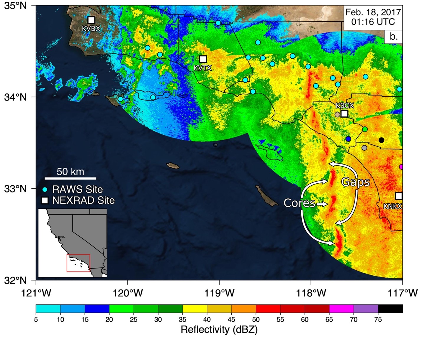
Narrow cold-frontal rainbands (NCFRs) are mesoscale features (fine-scale features, typically a few to tens of kilometers in spatial extent and lasting hours) that are embedded within extratropical cyclones, and can produce short-duration, high-intensity precipitation capable of triggering flash flooding or debris flows. Research related to NCFRs spans several decades and numerous case studies of these events have been used to improve understanding related to their development and evolution, forecasting, and impacts to affected communities (Cannon et al., 2020, Jorgensen et al., 2003, Houze et al., 1976, Sukup, 2016). Southern California is one such impacted region, where in 2017 a NCFR lead to the issuance of multiple warnings by local National Weather Service offices (Figure 1), and in 2018 where a NCFR passed over the Thomas Fire burn scar in Santa Barbara County, causing disastrous and deadly debris flows (Oakley et al. 2018). In an effort to create a comprehensive understanding of how these features have affected Southern California, we created a climatological record of these events manually using rain gauge observations and NEXRAD weather radar reflectivity imagery.
For the October-May period of years 1995-2020 we identified 94 individual NCFRs within the Southern California Bight, with as few as 0, as many as 10, and an average of 3 events occurring per water year, with a majority occurring in the late fall and winter months. Using atmospheric reanalysis, we identified common large-scale meteorological ingredients for NCFR events, including a low-pressure system off of the US West Coast, a decreasing sea level pressure tendency off the coast of Southern California, and an integrated water vapor maxima accompanied by an upper-level jet streak exit region within the study domain. Radar reflectivity composites of NCFR events suggest San Diego County sees more frequent intense landfalling NCFRs as compared to the rest of Southern California, though future work is needed to verify this is not a bias in radar observation. Additional results related to the movement characteristics of a sub-sample of events show that individual NCFR cores tend to move towards the east at an average speed of 14 m/s. Relationships between the identified NCFRs and National Weather Service Warnings reveal that although numerous events (45) are associated with at least one flash flood, severe thunderstorm, or tornado warning, only a small number of extreme NCFR events (15) are associated with many (>10) warnings.
This research supports the CW3E goal of advancing the understanding and projections of extreme precipitation events by laying the foundation for deeper dives into how NCFRs impact Southern California and how to improve forecasting of these events. The regional NCFR catalogue developed provides a large set of events that can be used to examine how numerical weather prediction models represent these mesoscale systems, especially in the presence of complex topography, which is found throughout Southern California. In addition, the NCFR catalogue provides a novel training dataset that can be used to develop an automated detection algorithm for NCFRs using radar reflectivity data. NCFRs have been shown to be impactful precipitation events in Southern California and other mid-latitude regions of the world associated with forecast uncertainty, motivating the need to allocate further effort towards understanding and forecasting them. Broadly, the work presented here, as well as future work, may be applied to other mid-latitude regions that are affected by extratropical cyclones and where radar data are available.
Figure 1: Radar reflectivity of a Narrow Cold-Frontal Rainband impacting Southern California on February 18, 2017. Orange-to-red colors indicate areas of higher intensity rainfall while blue to green colors indicate areas of lighter rainfall. Non-cyan colored circles indicate remote automatic weather station (RAWS) sites that correspond to the precipitation time series shown in the manuscript. Also note the classic gap and core structure, where high intensity cores are located adjacent to low intensity gap regions.
de Orla-Barile, M., Cannon, F., Oakley, N. S., & Ralph, F. M. (2022). A climatology of narrow cold-frontal rainbands in Southern California. Geophysical Research Letters, 49, e2021GL095362. https://doi.org/10.1029/2021GL095362
References
Cannon, F., Oakley, N. S., Hecht, C. W., Michaelis, A., Cordeira, J. M., Kawzenuk, B., Demirdjian, R., Weihs, R., Fish, M. A., Wilson, A. M., Ralph, F. M., (2020). Observations and predictability of a high-impact narrow cold-frontal rainband over Southern California on 2 February 2019. Weather Forecasting, 1-40
Houze, R. A., Hobbs, P. V., Biswas, K. R., & Davis, W. M. (1976). Mesoscale Rainbands in Extratropical Cyclones. Monthly Weather Review, 104(7), 868–878. https://doi.org/10.1175/1520-0493(1976)104<0868:MRIEC>2.0.CO;2
Jorgensen, D. P., Pu, Z., Persson, P. O. G., & Tao, W.-K. (2003). Variations Associated with Cores and Gaps of a Pacific Narrow Cold Frontal Rainband. Monthly Weather Review, 131(11), 2705–2729. https://doi.org/10.1175/1520-0493(2003)131<2705:VAWCAG>2.0.CO;2
Oakley, N. S., Cannon, F., Munroe, R., Lancaster, J. T., Gomberg, D., & Ralph, F. M. (2018b). Brief Communication: Meteorological and Climatological Conditions Associated with the 9 January 2018 Post-Fire Debris Flows in Montecito and Carpinteria, California, USA. Natural Hazards and Earth System Sciences, 18(11), 3037–3043. https://doi.org/10.5194/nhess-18-3037-2018
Sukup, S., Laber, J., Sweet, D., & Thomson, R. (2016). Analysis of an intense narrow cold frontal rainband and the Springs Fire burn area debris flows of 12 December 2014 (NWS Technical Attachment 1601). Los Angeles/Oxnard, CA: National Weather Forecast Office. Retrieved from https://www.weather.gov/media/wrh/online_publications/TAs/TA1601.pdf

