
CW3E Publication Notice
Impact of Airborne Radio Occultation Observations on Short Term Precipitation Forecasts of an Atmospheric River
July 16, 2025
A new article titled “Impact of Airborne Radio Occultation Observations on Short Term Precipitation Forecasts of an Atmospheric River,” by Nghi Do, Jennifer S. Haase, Bing Cao (Scripps Institution of Oceanography, University of California San Diego), Ivette Hernández Baños (NSF National Center for Atmospheric Research), and Pawel Hordyniec (Wrocław University of Environmental and Life Sciences), has been published in Geophysical Research Letters, a journal of the American Geophysical Union.
This study evaluates the impact of assimilating Global Navigation Satellite System (GNSS) Airborne Radio Occultation (ARO) observations into short-term forecasts of an Atmospheric River (AR) event using the Model for Prediction Across Scales – Atmosphere (MPAS-A) coupled with the Joint Effort for Data Assimilation Integration (JEDI) system (MPAS-JEDI, Liu et al., 2022).
ARO is a GNSS-based technique that retrieves thermodynamic profiles by measuring delays in navigation signals as they pass through the atmosphere at low elevation angles (Haase et al., 2014). Unlike dropsondes, ARO can capture continuous, high-resolution vertical profiles of atmospheric refractivity to the sides and below the aircraft flight path, including through cloud-covered regions and near the surface. The ARO system used in this study was mounted on United States Air Force WC-130J reconnaissance aircraft and collected 189 refractive bending angle profiles during two intensive observation periods in AR Reconnaissance 2023 (Figure 1). These profiles extended up to 450 kilometers horizontally from the aircraft track and offered vertical resolution ranging from 350 meters near the surface to 200 meters at flight level (Cao et al., 2025).
The assimilation of these ARO observations, using both ensemble-based (Local Ensemble Transform Kalman Filter) and variational (Three-Dimensional Ensemble-Variational) data assimilation methods, led to improvements in the representation of moisture and temperature fields in regions surrounding the AR. Notably, the study found that assimilating ARO data resulted in more accurate forecasts of integrated vapor transport at landfall and reduced precipitation forecast errors over Washington, Oregon, and Idaho by up to 3.5% for 36–54 hour lead times (Figure 2).
This work demonstrates the added value of ARO as a complementary observation system to dropsondes within AR Reconnaissance campaigns and illustrates the readiness of both ARO instrumentation and MPAS-JEDI to support high-impact weather forecasting. With GNSS ARO systems now operational on all ten WC-130J aircraft, this study paves the way for broader, systematic investigations and future integration into operational forecast workflows. Additionally, this work supports the Novel Observations priority identified in CW3E’s Strategic Plan.
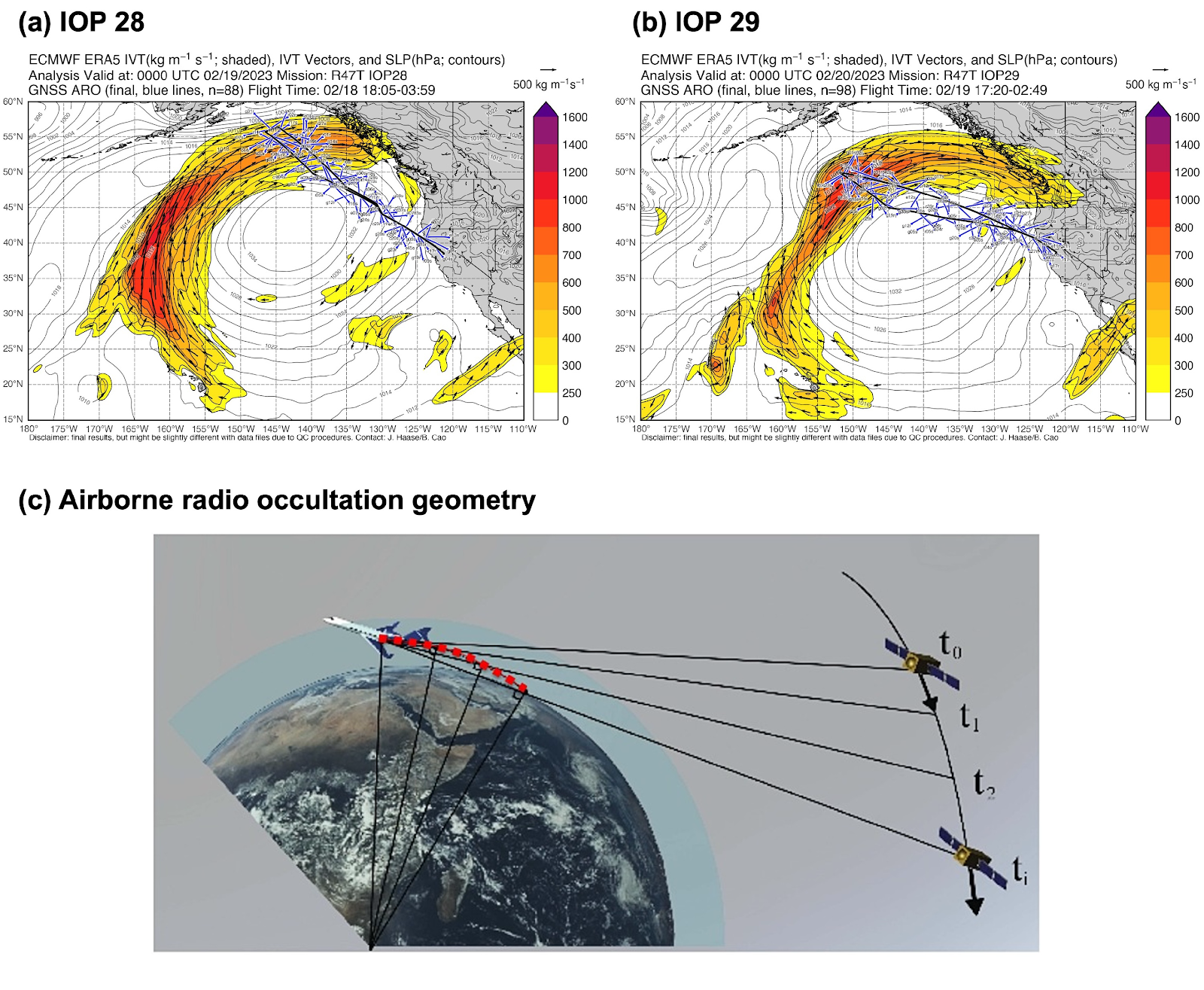
Figure 1. ARO observations from the C-130 centered at time a) 0000 UTC 19 February 2023 (IOP28), and b) 0000 UTC 20 February 2023 (IOP29). IVT (shaded with vectors) and mean sea level pressure (contours) are illustrated with the locations of ARO tangent point profiles (blue lines) and the flight path of the C-130 aircraft (black lines). (c) Airborne radio occultation geometry. GPS signals are recorded as satellites rise or set, with raypaths sampling different atmospheric layers. Each ray’s closest point to Earth, the tangent point, is where refractive delays are strongest due to denser atmosphere. For a setting satellite, these points (shown as red dots) drift horizontally away from the aircraft with decreasing altitude. Atmospheric refractivity is retrieved along these slanted tangent point profiles. Adapted from Haase et al. (2014).
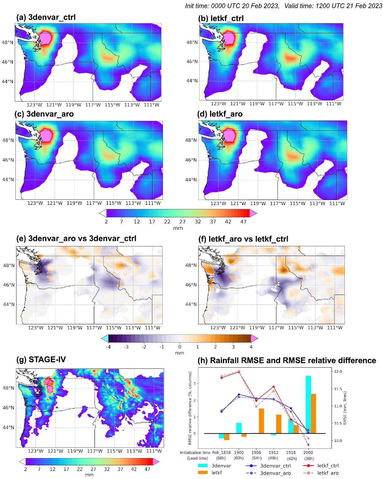
Figure 2. (Figure 3 from Do et al. (2025)). The 24‐hr accumulated precipitation (mm) from 1200 UTC 20 to 1200 UTC 21 February 2023 (12–36 hr forecast from 0000 UTC 20 February) for (a) 3denvar_ctrl, (b) letkf_ctrl, (c) 3denvar_aro, (d) letkf_aro, and (g) STAGE‐IV. Absolute error differences: (e) 3denvar_aro versus 3denvar_ctrl, (f) letkf_aro versus letkf_ctrl. (h) Rainfall RMSE (lines) and RMSE relative differences (columns) between experiments 3denvar_aro versus 3denvar_ctrl and letkf_aro versus letkf_ctrl compared with STAGE‐IV.
Cao, B., Haase, J. S., Murphy, M. J., & Wilson, A. M. (2025). Observing atmospheric rivers using multi‐GNSS airborne radio occultation: System description and data evaluation. Atmospheric Measurement Techniques Discussions (pp. 1–44). https://doi.org/10.5194/amt-2024-119
Do, P.‐N., Haase, J. S., Baños, I. H., Hordyniec, P., & Cao, B. (2025). Impact of Airborne Radio Occultation Observations on Short Term Precipitation Forecasts of an Atmospheric River. Geophysical Research Letters, 52, e2025GL115639. https://doi.org/10.1029/2025GL115639
Haase, J. S., Murphy, B. J., Muradyan, P., Nievinski, F. G., Larson, K. M., Garrison, J. L., & Wang, K.‐N. (2014). First results from an airborne GPS radio occultation system for atmospheric profiling. Geophysical Research Letters, 41(5), 1759–1765. https://doi.org/10.1002/2013GL058681
Liu, Z., Snyder, C., Guerrette, J. J., Jung, B.‐J., Ban, J., Vahl, S., et al. (2022). Data assimilation for the Model for Prediction Across Scales – Atmosphere with the Joint Effort for Data assimilation Integration (JEDI-MPAS 1.0.0): EnVar implementation and evaluation. Geoscientific Model Development, 15(20), 7859–7878. https://doi.org/10.5194/gmd-15-7859-2022