CW3E Publication Notice
Investigating the atmospheric conditions associated with impactful shallow landslides in California (USA)
November 05, 2024
“Investigating the atmospheric conditions associated with impactful shallow landslides in California (USA)” was recently published in Earth Interactions. This work was a collaboration among scientists from CW3E, the California Geological Survey, and the U.S. Geological Survey. The project was supported by the U.S. Geological Survey Landslide Hazards Program and the California Department of Water Resources Atmospheric River Program.
Landslides pose a threat to life, property, and infrastructure in mountainous areas of California. Previous work has focused on antecedent and within-storm rainfall triggering thresholds. However, site-specific rainfall information is not always available and there is uncertainty in these thresholds. This work explores whether there are common meteorological characteristics associated with landslide events that could aid in their prediction.
Previous research has noted the connection between atmospheric rivers and landslides. This analysis expands on previous work by exploring numerous atmospheric characteristics of landslide-producing storms in detail, including variables associated with ARs. The investigation evaluates 18 widespread shallow landslide events occurring in 13 unique storms where landslide timing could be constrained to a 6-hour window. Working with well-constrained landslide timing allows for evaluation of synoptic-to-mesoscale atmospheric characteristics associated with each event that would not be possible if longer time windows were used.
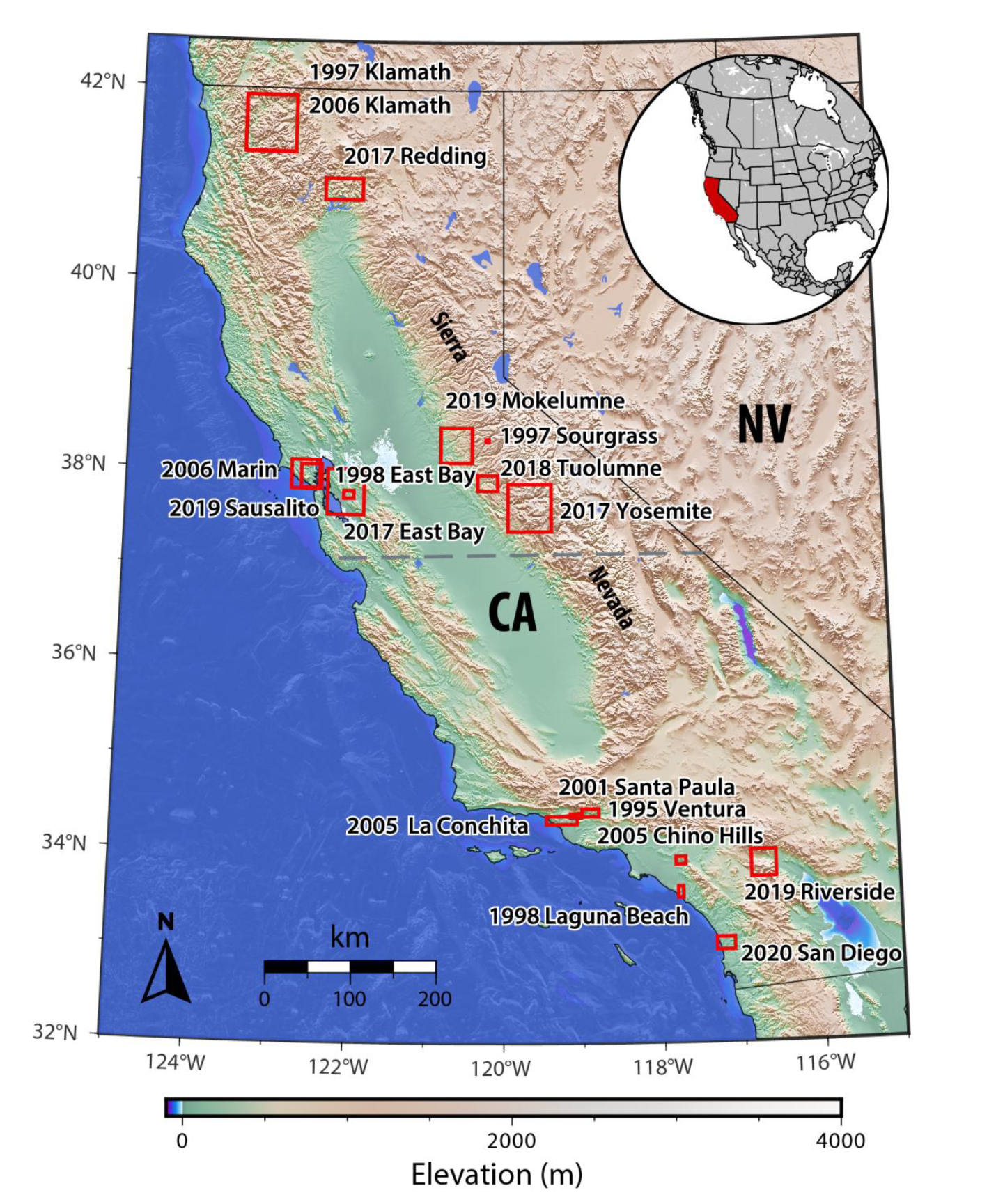
Figure 1. As in Figure 2 from Oakley et al. 2024; Location and year of landslide events in this analysis.
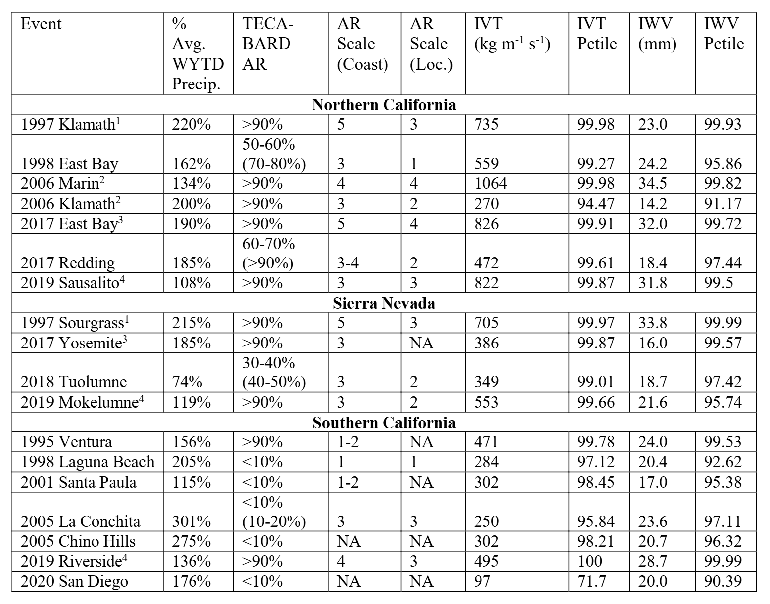
Results indicate that landslides occur under a broad range of synoptic patterns across the state. ARs were more prevalent in landslide producing storms in northern California than southern California, and the strength of AR conditions in landslide-producing storms was generally higher in northern California. Two-thirds of the 18 landslide events had Integrated Water Vapor Transport (IVT) exceeding the 99th percentile for the cool season and roughly 40% the events had Integrated Water Vapor (IWV) exceeding the 99th percentile. Nearly all events occurred with the upper-level jet stream overhead, and often associated with areas of the jet favorable for strong upward vertical motions. All 18 events were associated with Convective Available Potential Energy (CAPE) greater than 80th percentile for the season at the landslide location, with 12 greater than 95th percentile. High intensity rainfall features with radar reflectivity >50 dBZ were present in seven of 18 events. All but one landslide event had above normal Water Year (October 1) to-date precipitation, and that event featured a very intense, slow moving convective band, suggesting that the mesoscale characteristics of storms (e.g., embedded convection) may overcome below-average antecedent precipitation conditions and trigger landsliding.
Table 1. As in Table 2 from Oakley et al. 2024; Rainfall and moisture variable characteristics for landslide events. The “Event” column provides the event name (See Table 1 in Oakley et al. 2024). Superscripts in the “Event” column indicate landslide events that happened in different locations in the same storm. The “% Avg. WYTD Precip.” column provides the percent of water year to-date average precipitation prior to the landslide event. The “TECA-BARD AR” column provides the percent likelihood of detection of an AR object based on the TECA-BARD detection algorithm for a 6-hour period (24-hour period). Where no (24-hour) value is provided, the 24-hour value was equal to 6 hours. The “AR Scale (Coast)” column provides the AR Scale value at the coastal landfall location west of the landslide. A range is provided where the coastal scale is ambiguous. The “AR Scale (Loc.)” column provides the AR Scale value at the landslide location. For both AR Scale columns, “NA” indicates the location did not meet AR Scale criteria. The “IVT” and “IVT Pctile” columns provide the IVT value and percentile rank of the IVT value at the landslide location. The “IWV” and “IWV Pctile” columns provide the IWV value and the percentile rank of the IWV value at the landslide location.
Landslide producing storms occurred in all phases of the El Niño-Southern Oscillation; of the 13 storm events, six occurred during El Niño conditions, five during La Niña, and two during neutral conditions. However, five of seven storm events producing landslides in southern California occurred under El Niño condition, suggesting a stronger relationship in that region.
While some common characteristics were identified across landslide-producing storms, these storms share many characteristics of other hydrologically impactful storms that may or may not produce landslides. Further research is needed to discern between antecedent and in-storm characteristics associated with landslide activity or the lack thereof.
This work addresses the CW3E priority area of Atmospheric Rivers Research and Applications, as it explores atmospheric conditions associated with events including atmospheric rivers and their relation to landsliding to improve decision making associated with these hazards. It also addresses the priority area of Monitoring and Projections of Climate Variability and Change. This work provides new insights from research on historical extreme events to enhance conceptual understanding of these events. With an interdisciplinary team of geologists, engineers, and atmospheric scientists from state and federal agencies and university, this research displays the CW3E core value of Collaboration.
Oakley, N. S., Perkins, J. P., Bartlett, S. M., Collins, B. D., Comstock, K. H., Brien, D. L., Burgess, W. P., & Corbett, S. C. (2024). Investigating the atmospheric conditions associated with impactful shallow landslides in California (USA). Earth Interactions (Early Online Release) https://doi.org/10.1175/EI-D-24-0003.1


