CW3E Publication Notice
Vientos – A new satellite mission concept for 3D wind measurements by combining passive water vapor sounders with Doppler wind lidar
February 19, 2024
In the recent publication “Vientos – A new satellite mission concept for 3D wind measurements by combining passive water vapor sounders with Doppler wind lidar” in the Bulletin of the American Meteorological Society by CW3E collaborator and University of Arizona professor Xubin Zeng, among co-authors across institutions including CW3E’s Anna Wilson, propose a new satellite mission to address the challenge in accurately characterizing three-dimensional distribution of horizontal wind vectors (3D winds): Vientos. This proposed satellite mission will combine 2 or more passive water vapor sounders with Doppler wind lidar to accurately measure these 3D winds. This work contributes to CW3E’s 2019-2024 Strategic Plan, in particular the Priority Area dedicated to Atmospheric River Research and Applications by suggesting a transformative modernization of atmospheric measurements.
3D winds are integral to the Earth system, and yet, we do not currently have a method of accurately observing 3D winds with requisite space/time coverage. Information on 3D wind structures in and around atmospheric rivers in particular has the potential to be transformational for our understanding of the underlying processes. Further, our reliance on reanalysis data has been proved by recent studies to contain some systematic dynamical biases and errors. Thus, the need for Vientos is clear. The feasibility of the Vientos concept, which would retrieve 3D atmospheric motion vectors through tracking the movement of water vapor, followed by a bias correction using lidar measurements, has been proved doable by recent missions that explore combining active and passive observations as part of the global observing system.
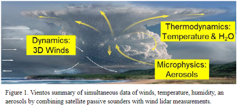
The Vientos mission would be able to address many scientific questions and contribute to a variety of applications. In addition to 3D wind observations, it would also provide 3D water vapor and temperature data while wind lidar provides aerosol measurements of the near storm environment (Figure 1, from the paper). This could provide many benefits to areas including but not limited to: numerical weather predictions, flight route planning in aviation, Forecast Informed Reservoir Operations (FIRO), wind energy, tracking transport of pollutants and aerosols, climate model evaluations, and carbon monitoring for international negotiations and policy making. Lastly, the essay explores different possible architectures of the project, each providing different resolutions and coverage based on budgets available coinciding with currently planned satellite missions.
Vientos emphasizes the synergy between passive sounders and wind lidar in a way that could fill a critical gap in Earth system scientific knowledge. To read more about the Vientos concept, access the entire publication here.
Zeng, X., Su, H., Hristova-Veleva, S., Posselt, D. J., Atlas, R., Brown, S. T., Dixon, R. D., Fetzer, E., Galarneau, T. J., Jr., Hardesty, M., Jiang, J. H., Kangaslahti, P. P., Ouyed, A., Pagano, T. S., Reitebuch, O., Roca, R., Stoffelen, A., Tucker, S., Wilson, A., Wu, L., & Yanovsky, I. (2024). Vientos – A new satellite mission concept for 3D wind measurements by combining passive water vapor sounders with Doppler wind lidar. Bulletin of the American Meteorological Society (published online ahead of print 2024). https://doi.org/10.1175/BAMS-D-22-0283.1

