
CW3E Publication Notice
GNSS Geodesy Quantifies Water‐Storage Gains and Drought Improvements in California Spurred by Atmospheric Rivers
July 12, 2024
In the recent publication, “GNSS Geodesy Quantifies Water‐Storage Gains and Drought Improvements in California Spurred by Atmospheric Rivers” published in the AGU journal by CW3E collaborator and University of Montana professor Hilary R. Martens, among co-authors across institutions including CW3E’s Qian Cao, Ming Pan, Anna Wilson, Ellen Knappe, and Marty Ralph, researchers utilize observations from Global Navigation Satellite Systems (GNSS), including surface-loading deformation, to quantify the impacts of Atmospheric Rivers in California on Terrestrial Water Storage (TWS) and drought indices. This work contributes to CW3E’s 2019-2024 Strategic Plan, in particular the Priority Area dedicated to Atmospheric River Research and Applications by integrating observations, theory, and modeling into decision support.
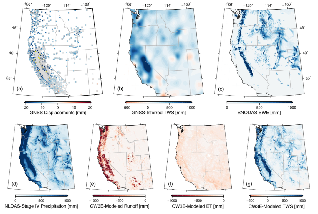
Figure 1. (a) Vertical displacement of Earth’s surface (red = uplift, blue = subsidence) from GNSS, (b) terrestrial water storage from the GNSS displacements, (c) snow water equivalent, (d) cumulative precipitation, (e) CW3E-modeled runoff, (f) CW3E-modeled evapotranspiration, (g) CW3E-modeled TWS changes for the western US from 1 October 2022 – 1 April 2023
Drought conditions and decreased water availability over the past few decades have become more common, raising concerns of a “mega drought” and the economic, political, health and safety, and ecological risks of continuing in a drought-like state. This urgently drives the need for studies such as this to utilize observational data to improve long-term and comprehensive water-management. As Atmospheric Rivers (ARs) typically account for about 30-50% of precipitation on the west coast with mountains serving as critical water reservoirs, this study focused on quantifying the increase in TWS following ARs hitting California using Earth-surface displacement from GNSS networks to track the changes in Earth’s shape to detect water losses and gains while focusing on Water year 2023 (WY23). WY23 (October 1, 2022 – April 1, 2023) was one of the strongest storm seasons in the western US on record and punctuated a severe drought period, and provided an opportunity to examine water storage changes in an extreme precipitation cycle. This study particularly looked at the Sierra Nevada mountains and the Sacramento-San Joaquin-Tulare (SST) river basin to observe the TWS gains over 17 years in comparison to drought conditions, evaluate the impact of ARs on the TWS, and identify the impact of individual storms in GNSS series to help improve water management.
This study found, through GNSS observations, that net gains in TWS in the first half of WY23 was the highest on record for the two watersheds studied, which demonstrated the seasonal storms’ abilities to bolster water resources in the area. This study also found that nearly all the water that was delivered into these watersheds from ARs remained in the watersheds as snowpack or liquid water, with subsurface reservoirs accounting for about 40% in the Sierra Nevada and 60% in SST watersheds of the total TWS gains. It was also shown that there was a recovery from meteorological and hydrological drought during the first half of WY23 based on two drought metrics.
This study was able to effectively broaden our understanding of how GNSS observations may be used to understand the signature of heavy AR storm seasons, and improve our water management practices. To read more about this application of GNSS, access the entire publication here.
Martens, H. R., Lau, N., Swarr, M. J.,Argus, D. F., Cao, Q., Young, Z. M., et al.(2024). GNSS geodesy quantifies water‐storage gains and drought improvements in California spurred by atmospheric rivers. Geophysical Research Letters, 51,e2023GL107721. https://doi.org/10.1029/2023GL107721.