Scripps and NOAA Researchers Take Flight to Observe Atmospheric River

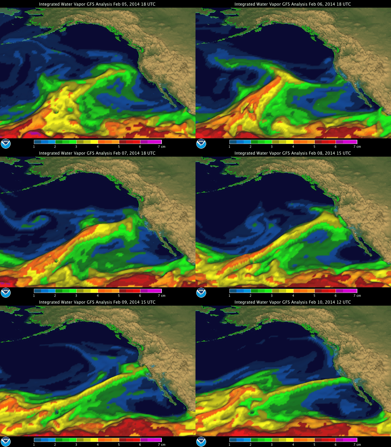
Integrated Water Vapor GFS Analysis Feb 5-10, 2014.
Researchers from Scripps Institution of Oceanography at UC San Diego, and NOAA are taking part in research flights to observe a distinctive type of storm system that has historically provided significant precipitation to California.
Scientists tracked the evolution of “atmospheric rivers,” narrow corridors of strong water vapor transport that can extend thousands of miles, as they made landfall in central California in early February. Atmospheric rivers (ARs), identified by researchers only in recent decades, can provide beneficial water supply and snowpack to the West Coast as well as create conditions for dangerous floods that affect lives and property. NOAA, Scripps, USGS, and other agency/institution researchers, working with water managers for the state, Sonoma County, and elsewhere, are studying them with the goal of providing better information for earlier and more accurate extreme weather forecasts. Scripps and USGS scientists are also looking at how atmospheric rivers may serve as “drought busters” and how climate change may affect atmospheric rivers in future decades.
Scripps researchers said that the February storms provided some relief, but would likely not reverse the dangerous drought conditions throughout California and the West that have built up over the last three years.
“Part of the reason for the drought has been the absence of atmospheric river storms hitting the region over the last year,” said Scripps climate researcher Marty Ralph. “From Feb. 7-10, a series of modest strength ARs hit Northern California, including near San Francisco and the northern Sierra where AR conditions stalled for up to 48 hours. These conditions created up to 12-15 inches of rain in three days, including in areas hit by the drought. This was more than double the precipitation in Northern California that had fallen in the first four months of the normal wet season. Nonetheless, the extreme drought has produced such a deficit in water that the soils absorbed much of the precipitation and rivers quickly receded to levels that are again well below normal, even though they reached fairly high levels during the storm.”
Ralph heads the Center for Western Water and Weather Extremes (CW3E), a new center established at Scripps Oceanography that is devoted to California’s special precipitation characteristics. At the core of the center will be a unique advanced network of monitoring stations throughout the state to help industries and 38 million California residents understand phenomena that affect the economy and everyday life in myriad ways.
The network, built over the last five years by NOAA and Scripps through support from California’s Department of Water Resources, will initially contain four atmospheric river observatories, monitoring stations located in Northern and central California that measure amounts of water vapor in the atmosphere and other climate variables.
“NOAA is very interested in improving our forecasts of extreme weather events, and atmospheric rivers rank with hurricanes as a major issue,” said Chris Fairall, chief of the Weather and Climate Physics branch of NOAA’s Earth System Research Laboratory in Boulder, Colo. “The West Coast relies on them for water, but it really is like trying to drink from the proverbial firehose. This new research collaboration on atmospheric rivers with Scripps and UC San Diego is a big step in attacking the problem.”
For this event, Ralph, Fairall, and colleagues gathered data aboard a NOAA Gulfstream IV aircraft that began flying over the Pacific Ocean off the U.S. West Coast on Feb. 7. During the flights, researchers measured several atmospheric properties at several locations along and across the atmospheric river corridor to better understand key processes, such as where the water vapor sources are and how they are sustained by storm dynamics.
Aboard the aircraft, researchers released small parachuted devices, called dropsondes, across the atmospheric river over the Pacific Ocean. As they descend, the dropsondes measure atmospheric conditions, such as pressure, temperature, humidity, wind speed and direction, and transmit the information back to the aircraft where a flight scientist uses it to guide the mission. After the dropsonde data are analyzed and processed, the information will be put into a standard format established by the World Meteorological Organization and provided to NOAA’s National Hurricane Center for inclusion in global and local-scale weather prediction models.
Mike Dettinger, a CW3E team member and research hydrologist with Scripps and the U.S. Geological Survey, noted that atmospheric rivers provide 30 to 50 percent of the precipitation in California and are behind 80 percent of the floodplain inundations along parts of the Central Valley where those inundations are a necessary part of ecosystem food webs and fish nurseries. They figure prominently in the ending of California droughts but also in taxing Northern California levees and other components of the state’s water delivery infrastructure.
“Thus, better understanding of how atmospheric rivers work and how they may change in the future is critical to better water, floods, and ecosystem management and to plans for adapting to future climate changes,” Dettinger said.
Jay Jasperse, chief engineer for the Sonoma County Water Agency, which provides water to 600,000 people and many agricultural users, said of the February storms, “although this AR may not be the strongest ever, it is certainly the most welcome.”
Results from this study will help guide atmospheric river research for the upcoming CalWater 2 experiment, which begins in 2015 and will use land-based stations and a research ship as well as multiple aircraft.
