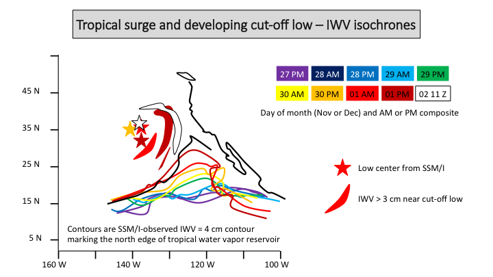
Short diagnosis of development of a tropic surge, cut-off low and AR features
December 2, 2014
Storm surge summary (slide 10; M. Ralph)
CW3E director Marty Ralph provides a short diagnosis of an interesting case with a variety of features coming together to generate very large IWV in this currently landfalling storm.
Dr. Ralph notes “This could be a useful event to diagnose more deeply given its relevance to many things we are working on, and the debates about AR, cut-off low, tropical moisture exports, etc. The IVT perspective needs to be explored as well, but the IWV features are quite telling. Jay Cordeira had shared a brief synopsis including a cross-section from GFS that showed the vapor transport over LA maximized at about 3.5 km, which may be more like a ‘tropical moisture export’ structure (Knippertz et al).”
(Please click here for powerpoint slides)
The attached ppt includes an isochrone analysis of the northern edge of the tropical water vapor reservoir (using 4 cm IWV – summary shown above and in slide 10) and its landfall (as seen in the GPS-Met network – slide 11). Also, the snow levels are well-observed with the new SLR network and shows strong north-south variation (slide 12)..
Forecasts are available from the California Nevada River Forecast Center (CNRFC): click here for precipitation forecasts..
Forecasts are also available from the weather service forecast office of the National Weather Service in San Diego: please click here.

