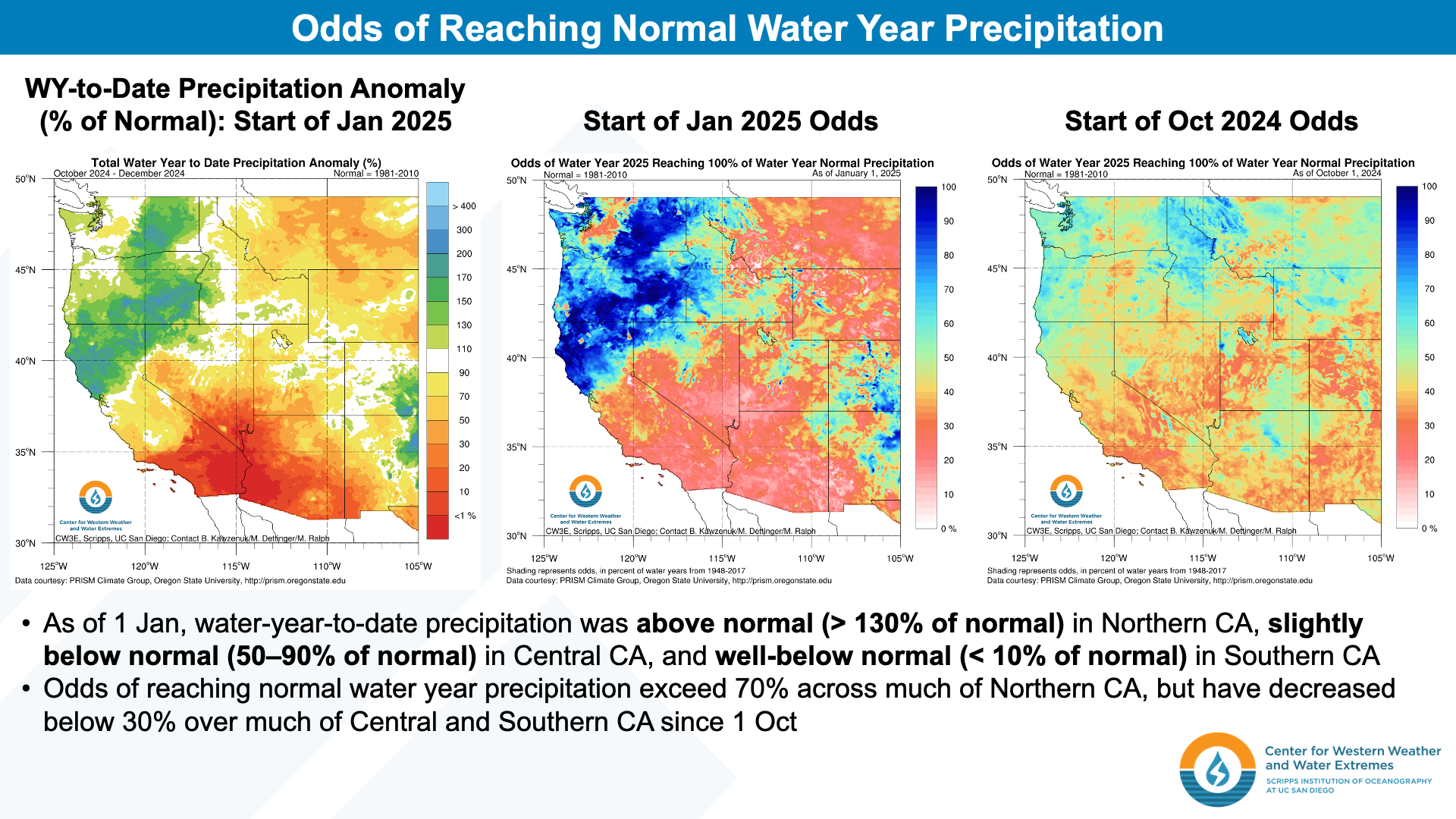
CW3E at the 2025 American Meteorological Society Annual Meeting
CW3E will be participating in the upcoming American Meteorological Society 105th Annual Meeting. Sessions chaired and presentations delivered or co-authored by CW3E researchers and collaborators are listed below in alphabetical order of first author (last name). CW3E researchers, post-docs, and graduate students are bolded. CW3E funded research collaborators or alumni are italicized.
Monday, 13 January 2025
3B.5 – R20 Observations and Model Verification of Landfalling ARs in Western Washington during early December 2023
Jason M. Cordeira, UCSD Scripps Institution of Oceanography, La Jolla, CA; and A. M. Wilson, C. Castellano, E. Knappe, R. Weihs, D. Axisa, and F. M. Ralph
15th Conference On Transition Of Research To Operations (15R2O)
2A.4 – Representation of High-Impact Weather in a Novel High-Resolution Climate-Scale Simulation using the Model for Prediction Across Scales – Atmosphere (MPAS-A)
James DiGilio, Northern Illinois University, DeKalb, IL; and A. C. Michaelis, W. E. Chapman, L. Getker, F. Cannon, D. F. Steinhoff, L. Delle Monache, G. M. Lackmann, B. Guan, and F. M. Ralph
38th Conference on Climate Variability and Change
2B.5 – How do Future Projected Changes in Winter Snowfall Patterns Affect Our Ability to Characterize Them?
Kayden Haleakala, Scripps Institution of Oceanography, La Jolla, CA; and A. C. Michaelis, W. T. Brandt, A. Cooper, G. Lewis, V. A. Gensini, PhD, CCM, W. S. Ashley, and T. Dixon
38th Conference on Climate Variability and Change
4.3 – Assessing the Impact of Air-Sea Coupling on Subseasonal Predictability of Atmospheric Rivers
Tien-Yiao Hsu, University of California San Diego, Scripps Institution of Oceanography, La Jolla, CA; and M. R. Mazloff, M. Zheng, R. Sun, S. T. Gille, M. Simpson, B. D. Cornuelle, and L. Delle Monache
13th Symposium on the Madden-Julian Oscillation and Sub-Seasonal Monsoon Variability
Poster 234 – MJO The Prediction Skills of Atmospheric Rivers over the Western United States in three Subseasonal Hindcast Models
Wen-Shu Lin, Scripps Institution of Oceanography, University of California San Diego, La Jolla, CA; and J. R. Norris, M. J. DeFlorio, and F. M. Ralph
13th Symposium on the Madden-Julian Oscillation and Sub-Seasonal Monsoon Variability
4B.6 – Atmospheric River Reconnaissance: 2025 Update
F. Martin Ralph, SIO, La Jolla, CA
41st Conference on Environmental Information Processing Technologies
3B.3 – Using Google Earth as a Flight Planning Tool for Atmospheric River Reconnaissance Flights
Shawn C. Roj, Center for Western Weather and Water Extremes, Scripps Institution of Oceanography, Univ. of California San Diego, La Jolla, CA; and B. Kawzenuk, A. M. Wilson, S. M. Bartlett, J. Ludtke, K. Hurley, and F. M. Ralph
15th Conference On Transition Of Research To Operations (15R2O)
3.1 – The Advanced Quantitative Precipitation Information (AQPI) Project: Improved Radar-based Observations and Forecasts for the San Francisco Bay Area
Jonathan J. Rutz, Scripps Institution of Oceanography, Univ. of California San Diego, La Jolla, CA; and V. Chandrasekar, R. B. Vilela, M. Steen, D. Roberts, and F. M. Ralph
29th Conference on Integrated Observing and Assimilation Systems for the Atmosphere, Oceans, and Land Surface (IOAS-AOLS)
4B.2 – How do AI How do AI Data-driven Models Compare with Physics-based Models in Predicting ARs and Extreme Precipitation in the Western US at Subseasonal Lead Times?
Agniv Sengupta, SIO, La Jolla, CA; and J. L. Bano Medina, Z. Liu, Z. Yang, J. Wang, Z. Zhang, M. J. DeFlorio, and L. Delle Monache
24th Conference on Artificial Intelligence for Environmental Science
4.1 – The NCEI Climate Data Record for Atmospheric Rivers: Initial Results over the Western United States
Emily A. Slinskey, Center for Western Weather and Water Extremes (CW3E) Scripps Institution of Oceanography University of California, San Diego, La Jolla, CA; and J. J. Rutz, B. Guan, and F. M. Ralph
13th Symposium on the Weather, Water, and Climate Enterprise
3.4 – Sensitivity of the Asian Summer Monsoon water vapor transport to Arabian Sea SST anomalies: A case study from 2023
Rui Sun, SIO La Jolla, CA; A. C. Subramanian, Tien Yao Hsu, A. J. Miller, and I. Hoteit
24th Conference on Air-Sea Interaction
Session 3B – Atmospheric River Reconnaissance: Observations, Science Advances, and Impact on Forecasts and Downstream Decision-Making: Part I
Chairs: Vijay Tallapragada, NOAA/NWS/Environmental Modeling Center, Anna M. Wilson, SIO, La Jolla, CA
15th Conference On Transition Of Research To Operations (15R2O)
J4B.4 – Evaluating the Impact of Dropsonde Data from the 2023-2024 Atmospheric River Reconnaissance on NCEP Operational GFS Forecasts
Vijay S. Tallapragada, NOAA/NWS/Environmental Modeling Center, College Park, MD; and X. Wu, K. Wu, F. M. Ralph, and A. M. Wilson
33rd Conference on Weather Analysis and Forecasting (WAF)/29th Conference on Numerical Weather Prediction (NWP)
3B.4 – A Climatology of Forecast Sensitivity for Landfalling Atmospheric Rivers along the US West Coast
Ryan D. Torn, Univ. at Albany, Albany, NY; and J. Cordeira and F. M. Ralph
15th Conference On Transition Of Research To Operations (15R2O)
4.5 – Association of Western US Compound Hydrometeorological Extremes with MJO and ENSO Interaction
Jiabao Wang, Univ. of California San Diego, La Jolla, CA; and M. J. DeFlorio, A. Gershunov, K. Guirguis, L. Delle Monache, and F. M. Ralph
13th Symposium on the Madden-Julian Oscillation and Sub-Seasonal Monsoon Variability
Tuesday, 14 January 2025
8A.4 – Are AI Data-Driven Weather Models Learning Atmospheric Physics? Initial Condition Sensitivity Analysis of Cyclone Xynthi
Jorge Luis Bano Medina, SIO, La Jolla, CA; and A. Sengupta, J. D. Doyle, C. A. Reynolds, D. Watson-Parris, and L. Delle Monache
24th Conference on Artificial Intelligence for Environmental Science
Poster 419 – Do AI Models Produce Better Atmospheric River Forecasts than Physics Based Models? A Quantitative Evaluation
Isaac Davis, Univ. of Colorado, Boulder, CO; and A. C. Subramanian, T. Higgins, and L. Delle Monache
24th Conference on Artificial Intelligence for Environmental Science
Poster 365 – Spatial and Temporal Distributions of North American and U.S. Surface Fronts Using NOAA/NCEP WPC Surface Analyses
Eric G. Hoffman, Plymouth State Univ., Plymouth, NH; and S. M. Bartlett, N. D. Metz, and J. Cordeira
33rd Conference on Weather Analysis and Forecasting (WAF)/29th Conference on Numerical Weather Prediction (NWP)
Poster 479 – Atmospheric River Reconnaissance – An Overview of Activities During Water Year 2024
Brian Kawzenuk, SIO, La Jolla, CA; and A. M. Wilson, S. Babbitt, S. C. Roj, P. Iniguez, M. Steen, J. Cordeira, J. J. Rutz, F. M. Ralph, and V. S. Tallapragada
15th Conference On Transition Of Research To Operations (15R2O)
Poster 404 – Comparison of AQPI X-Band and NEXRAD S-Band Radar-Estimated Rain Rates during an Extreme Atmospheric River Event
Matthew Steen, Center for Western Weather and Water Extremes, Scripps Institution of Oceanography, University of California San Diego, La Jolla, CA; and R. B. Vilela, J. J. Rutz, V. Chandrasekar, and B. Garcia
25th Symposium on Meteorological Observation and Instrumentation
Wednesday, 15 January 2025
J12C.5 – Incorporating Principles of Environmental Justice into Forecast Informed Reservoir Operations, a Climate and Flood Adaptation Strategy
Thomas Corringham, SIO, La Jolla, CA; and S. Ogle, E. Yeates, S. Madonia, D. Nelson, F. M. Ralph, and J. M. Shepherd
39th Conference on Hydrology/20th Symposium on Societal Applications: Policy, Research and Practice/Sixth Symposium on Diversity, Equity, and Inclusion
12B.2 – Evaluation of West-WRF with Noah-MP for Hydrometeorological Prediction in California
Samuel Dahl, The University of Arizona, Tucson, AZ; University of Arizona, Tucson, AZ; and X. Zeng, M. A. Brunke, D. F. Steinhoff, M. Simpson, and L. Delle Monache
33rd Conference on Weather Analysis and Forecasting (WAF)/29th Conference on Numerical Weather Prediction (NWP)
Session 11A – Atmospheric Rivers: Processes, Impacts, and Communicating Uncertainty I
Co-Chairs: Bin Guan, UCLA; Christine Shields, NCAR; Alexandre Ramos, KIT
38th Conference on Climate Variability and Change
12B.5 – Verification of Marine Boundary Layer Forecasts in Atmospheric River Environments using Dropsonde Observations
Kevin M. Lupo, Center for Western Weather and Water Extremes, Scripps Institution of Oceanography, University of California San Diego, La Jolla, CA; and M. Simpson and F. M. Ralph
33rd Conference on Weather Analysis and Forecasting (WAF)/29th Conference on Numerical Weather Prediction (NWP)
11A.2 – Climate Change Effects on the December 2022 – January 2023 High Impact Series of Atmospheric Rivers Along the U.S. West Coast
Hunter Martinez-Buehrer, Northern Illinois University, Dekalb, IL; and A. C. Michaelis, J. Cordeira, A. Gershunov, V. A. Gensini, PhD, CCM, A. Haberlie, W. S. Ashley, and F. M. Ralph
38th Conference on Climate Variability and Change
12B.6 – Benefits and Tradeoffs of Ensemble Resolution versus Ensemble Size for Orographic Precipitation Forecasts
Nora Rose Mascioli, SIO, La Jolla, CA; and D. F. Steinhoff, M. Simpson, M. Ghazvinian, R. Weihs, C. Papadopoulos, and L. Delle Monache
33rd Conference on Weather Analysis and Forecasting (WAF)/29th Conference on Numerical Weather Prediction (NWP)
11A.3 – Characteristics, Impacts, and Historical Perspectives of Atmospheric Rivers along the U.S. East Coast during Winter 2023–2024
Nicholas D. Metz, Hobart & William Smith Colleges, Geneva, NY; and J. Cordeira, H. B. Kostka, X. Zou, E. A. Slinskey, and F. M. Ralph
38th Conference on Climate Variability and Change
9B.4 – Differentiating between Impactful and Non-Impactful Atmospheric River Events in Southeast Alaska
Deanna Nash, J. J. Rutz, A. Jacobs, NWS, Juneau, AK
39th Conference on Hydrology
12A.3 – Inland-penetrating Atmospheric Rivers and Hydrometeorological Impacts in Colorado
Deanna L. Nash, Scripps Institution of Oceanography, Univ. of California San Diego, La Jolla, CA; and J. J. Rutz, J. Cordeira, F. M. Ralph, K. J. Sanders, and E. Walter
38th Conference on Climate Variability and Change
11.5 – Influence of the Sierra Barrier Jet on the Distribution of Precipitation in Northern California
Yazmina Rojas Beltran, Center for Western Weather and Water Extremes, Scripps Institution of Oceanography, UCSD, La Jolla, CA; and J. Cordeira
Fourth Symposium on Mesoscale Processes
Poster 825 – Howard Hanson Dam Operations with Forecast Informed Reservoir Operations and Climate Change
Michael Warner, US Army Corps of Engineers – Seattle District, Tacoma, WA; and S. Marxen, K. Brettmann, K. Comanor, A. McCall, R. Aoki, C. Talbot, and F. M. Ralph
13th Symposium on the Weather, Water, and Climate Enterprise
Poster 623 – The Role of Atmospheric Rivers in the Snowpack over the Upper Colorado River Basin during Water Year 2023
Zhenhai Zhang, Scripps Institution of Oceanography, Univ. of California San Diego, La Jolla, CA; F. M. Ralph, J. J. Rutz, and D. L. Nash
38th Conference on Climate Variability and Change
Thursday, 16 January 2025
15B.2 – What is the minimum ensemble size to reduce the uncertainty in the skill of West-WRF hydrometeorological forecasts over California?
Michael A. Brunke, The University of Arizona, Tucson, AZ; and W. D. Scheftic, L. W. Siu, X. Zeng, L. Delle Monache, M. Simpson, and D. F. Steinhoff
33rd Conference on Weather Analysis and Forecasting (WAF)/29th Conference on Numerical Weather Prediction (NWP)
Session 13 – Weather, Water, and Climate Applications for financial Decision-making I
Chairs: Jason Cordeira, UCSD Scripps, La Jolla, CA; Jon B. Davis, Barcelona, B. Spain
New Orleans Forum on Climate Linked Economics
Session 14 – Weather, Water, and Climate Applications for Financial Decision-making II
Chairs: Jason M. Cordeira, CW3E, UCSD Scripps Institution of Oceanography, La Jolla, CA; Jon B. Davis, Barcelona, B, Spain
New Orleans Forum on Climate Linked Economics
Poster E98 – Deep Learning based Postprocessing for Freezing Level Forecasting over FIRO Watersheds
Vesta Afzali Gorooh, Center for Western Weather and Water Extremes, Scripps Institution of Oceanography, Univ. of California, San Diego, La Jolla, CA; and S. Roj, A. Sengupta, M. Ghazvinian, J. L. Bano Medina, R. Weihs, D. Axisa, J. F. Kalansky, and L. Delle Monache
24th Conference on Artificial Intelligence for Environmental Science
Poster 962 – AI Two-Step Machine Learning Process for Precipitation Nowcasting over the UAE Region
Eun Yeol Kim, Colorado State University, Fort Collins, CO; and V. Chandrasekar and L. Delle Monache
24th Conference on Artificial Intelligence for Environmental Science
14B.2 – Potential Benefits of Convection-Allowing Initial Conditions in a Variable-Resolution Global Data Assimilation System
Craig Schwartz, NCAR, Boulder, CO, J. Bresch, K. M. Lupo, J. Ban, J. Guerrette, B. Jung, Z. Liu, C. Snyder, S. Vahl, Y. Doy, Y.G. Yu
29th Conference on Integrated Observing and Assimilation Systems for the Atmosphere, Oceans, and Land Surface (IOAS-AOLS)
13.1 – Invited Speaker in Climate Linked Economics: Realized Benefits of Balancing Competing Purposes at US Army Corps of Engineers Reservoirs by Using Forecast Informed Reservoir Operations
Cary Talbot, PhD, PE, US Army Corps of Engineers, Vicksburg, MS; U.S. Army Engineer Research and Development Center, Vicksburg, MS; and F. M. Ralph
New Orleans Forum on Climate Linked Economics
14.3 – Atmospheric River and Foehn Warming Effects over the Antarctic Peninsula
Xun Zou, Scripps Institution of Oceanography, University of California San Diego, La Jolla, CA; and P. Rowe, I. V. Gorodetskaya, D. H. Bromwich, M. A. Lazzara, Z. Zhang, B. Kawzenuk, A. Orr, N. Hansen, J. Cordeira, and F. M. Ralph
Fourth Symposium on Mesoscale Processes