CW3E Publication Notice
A Climatological Study of National Weather Service Watches, Warnings, and Advisories and Landfalling Atmospheric Rivers in the Western U.S. 2006–2018
April 30, 2021
Samuel Bartlett, a student at Plymouth State University, recently published a paper (Bartlett and Cordeira, 2021) in Weather and Forecasting with co-author and close CW3E collaborator, Plymouth State University professor Jason Cordeira.
As part of an effort to quantify the benefit-hazard spectrum of landfalling ARs and leverage the Ralph et al. (2019) AR scale, the study used 13 years of NWS watch, warning, and advisory (WWA) data to illustrate the relationships between landfalling ARs and potentially hazardous weather across the western US. This study contributes to the goals of CW3E’s 2019-2024 Strategic Plan to support Atmospheric River (AR) Research and Applications by quantifying the relationship between AR rank (strength and duration) and the AR’s potential hazard footprint, providing critical information to support decision makers in the west.
While a WWA is not necessarily a storm report and is influenced by local thresholds, climate, and possibly forecast best practices across WFOs, it does provide a lens into where hazardous weather was at least locally anticipated associated with landfalling ARs. The study quantifies and summarizes the following five key points at forecast zones across the west:
- A majority of WWAs issued in advance of potentially hazardous weather across the western US occur in association with landfalling ARs
- WWAs issued in advance of potentially hazardous weather are increasingly more likely to occur in association with more intense and longer duration ARs (i.e., as AR scale increases)
- Not all landfalling ARs necessarily require WWAs (i.e., not all ARs are hazardous)
- More intense and longer duration ARs are more likely to require WWAs as compared to less intense and shorter duration ARs (i.e., more intense and longer duration ARs are more hazardous)
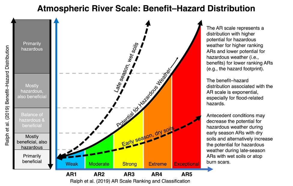
- The hazard footprint of landfalling ARs, especially for “hydrologic hazards”, increases exponentially as AR scale increases
Based on the results of this study, a similar smaller study by Cordeira et al. (2018), the results from Corringham et al. (2019; exponential increase in flood damages following AR scale), and the known influence of antecedent conditions on hazards (i.e., an AR5 in October on dry soil may not be hazardous), we created the following schematic illustrating a benefit-hazard spectrum for the AR scale (Fig. 1):
Figure 1: Fig. 12 from Bartlett and Cordeira (2021). A generalized schematic illustration of the exponential increase in the potential for hazardous weather in the western U.S., in this study defined by the “hazard footprint” of WWAs and in Corringham et al. (2019) defined by flood damages, associated with the Ralph et al. (2019) AR scale. Text annotation embedded within the schematic is intended to support interpretation, including the influence of antecedent conditions in modulating the potential for hazardous weather.
Bartlett, S. M., & Cordeira, J. M. (2021). A Climatological Study of National Weather Service Watches, Warnings, and Advisories and Landfalling Atmospheric Rivers in the Western U.S. 2006–2018, Weather and Forecasting, https://doi.org/10.1175/WAF-D-20-0212.1.

