CW3E Publication Notice
Atmospheric river precipitation enhanced by climate change: A case study of the storm that contributed to California’s Oroville Dam crisis
March 8, 2022
Allison Michaelis, an Assistant Professor at Northern Illinois University, along with co-authors Sasha Gershunov (SIO/CW3E), Alexander Weyant (SIO), Meredith Fish (SIO alumna), Tamara Shulgina (CW3E), and F. Martin Ralph (CW3E), recently published a paper titled “Atmospheric river precipitation enhanced by climate change: A case study of the storm that contributed to California’s Oroville Dam crisis” in Earth’s Future. This study supports CW3E’s 2019-2024 Strategic Plan involving Atmospheric Rivers (AR) Research and Applications by quantifying the effects of climate change on a recent impactful AR event.
Michaelis et al. (2022) took a novel modeling approach to simulate the AR that contributed to the Oroville Dam crisis in early February 2017 (the Oroville AR) under global climate conditions representing pre-industrial, present-day, mid-, and late-21st century environments using the Model for Prediction Across Scales-Atmosphere (MPAS-A). The Oroville AR occurred between 6–11 February 2017 as two successive midlatitude cyclones in the eastern North Pacific basin moved onshore, creating multiple pulses of elevated IVT, and leading to sustained AR conditions over the Feather River Basin in Northern California for several days. The two AR pulses were quite distinct, both in terms of IVT orientation and temperature. The first pulse on 7 February was westerly and cool, producing significant snow on top of an already impressive snowpack, while the second pulse on 9 February had a more southerly orientation, was warmer with a higher snowline, and produced comparable amounts of total precipitation with more rain and less snow. Previous work estimated that melting due to rain-on-snow produced extreme runoff with snowmelt contributing between 25–50% of the total runoff and reservoir inflow from the AR.
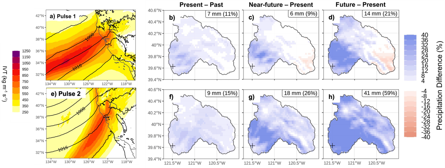
We estimate that climate change-to-date resulted in a ~11% and ~15% increase in precipitation over the Feather River Basin for the first and second pulses, respectively. Regarding future climate change, the first pulse of the Oroville AR showed precipitation increases of 9% and 21% through the mid- and late-21st century, respectively. Precipitation enhancements for the second pulse were almost tripled comparatively with a 26% increase through the mid-21st century and a 59% increase through the late-21st century. Although both pulses were enhanced by the imposed climate changes, the thermodynamic response and subsequent precipitation increases were most substantial during the second pulse. Such AR family dynamics provide a partial answer to why—although climate change, as we show here, has already contributed notably to precipitation from the Oroville AR—we have not yet clearly observed a trend in AR-related precipitation over our 70+ years of record. With continued global warming, however, we expect to soon see the anthropogenic trend emerge from natural variability in AR-related precipitation in California and other AR-targeted regions. The non-stationary nature of our climate system, particularly that due to human activity, manifesting on timescales of several human generations, requires a continual recalculation and readjustment of risks due to the changing nature of specific weather extremes as the climate crisis and global society’s responses to it evolve.
Figure 1: MPAS-A present-day ensemble mean IVT (kg m-1 s-1; shading) and sea-level pressure (SLP; hPa; black contours) for (a) 15 UTC 7 February 2017 and (e) 18 UTC 9 February 2017 during the first and second AR pulses, respectively. Difference in accumulated precipitation (% change) during the (b)–(d) first AR pulse from 06 UTC 7 February – 06 UTC 8 February and (f)–(h) second AR pulse from 03 UTC 9 February – 06 UTC 10 February for MPAS-A ensemble mean (b),(f) present minus past, (c),(g) near-future minus present, and (d),(h) future minus present. Absolute (mm) and percent changes (%) are reported in the top right corners of (b)–(d) and (f)–(h). The Oroville Dam location is indicated by a “+” in all panels. Adapted from Figures 2 and 4 in Michaelis et al. (2022).
Michaelis, A. C., Gershunov, A., Weyant, A., Fish, M. A., Shulgina, T., & Ralph, F. M. (2022). Atmospheric river precipitation enhanced by climate change: A case study of the storm that contributed to California’s Oroville Dam crisis. Earth’s Future, 10, e2021EF002537. doi: https://doi.org/10.1029/2021EF002537

