CW3E Publication Notice
Development of a Statistical Subseasonal Forecast Tool to Predict California Atmospheric Rivers and Precipitation Based on MJO and QBO Activity
April 21, 2023
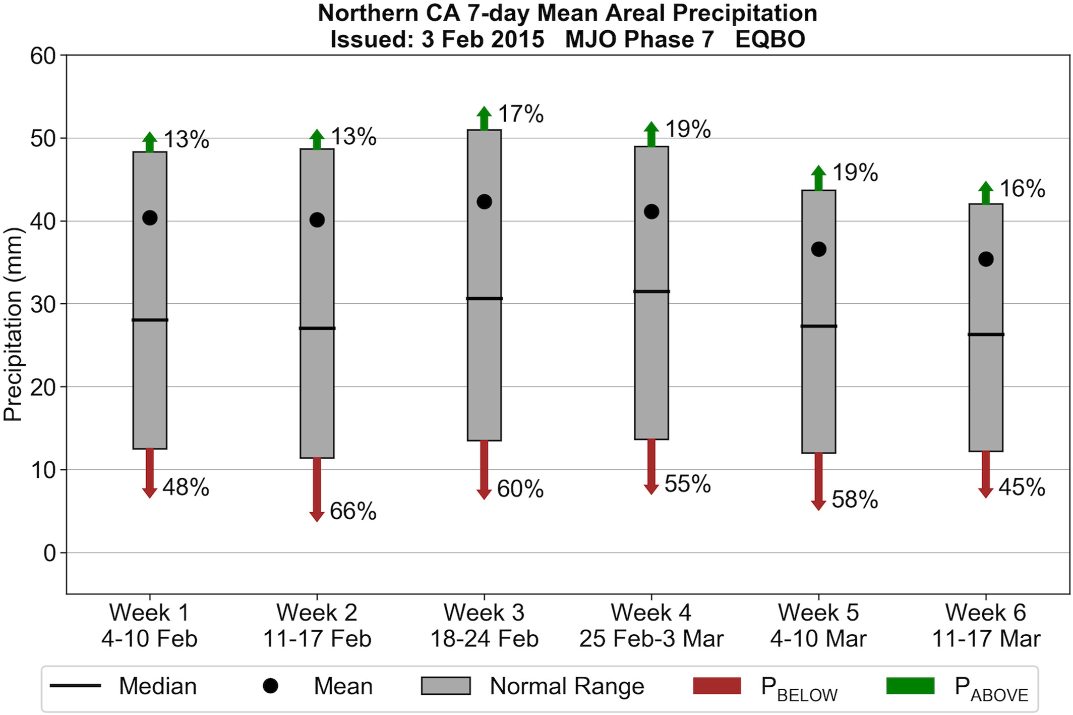
A new paper entitled “Development of a Subseasonal Statistical Forecast Tool to Predict California Atmospheric Rivers and Precipitation Based on MJO and QBO Activity” and authored by CW3E staff researcher Christopher Castellano, Michael DeFlorio, Peter Gibson (NIWA), Luca Delle Monache, Julie Kalansky, Jiabao Wang, Kristen Guirguis, Alexander Gershunov, F. Martin Ralph, Aneesh Subramanian (University of Colorado Boulder), and Michael Anderson (California DWR) was recently published in the Journal of Geophysical Research: Atmospheres. This research contributes to CW3E’s 2019–2024 Strategic Plan to improve atmospheric river (AR) prediction on subseasonal-to-seasonal (S2S) time scales by examining the relationship between the Madden–Julian oscillation (MJO), the quasi-biennial oscillation (QBO), and AR activity and precipitation in California. The authors also introduced an experimental forecast tool to predict the likelihood of above-normal and below-normal AR activity and precipitation at subseasonal lead times of 1–6 weeks based on the phase and amplitude of the MJO and QBO.
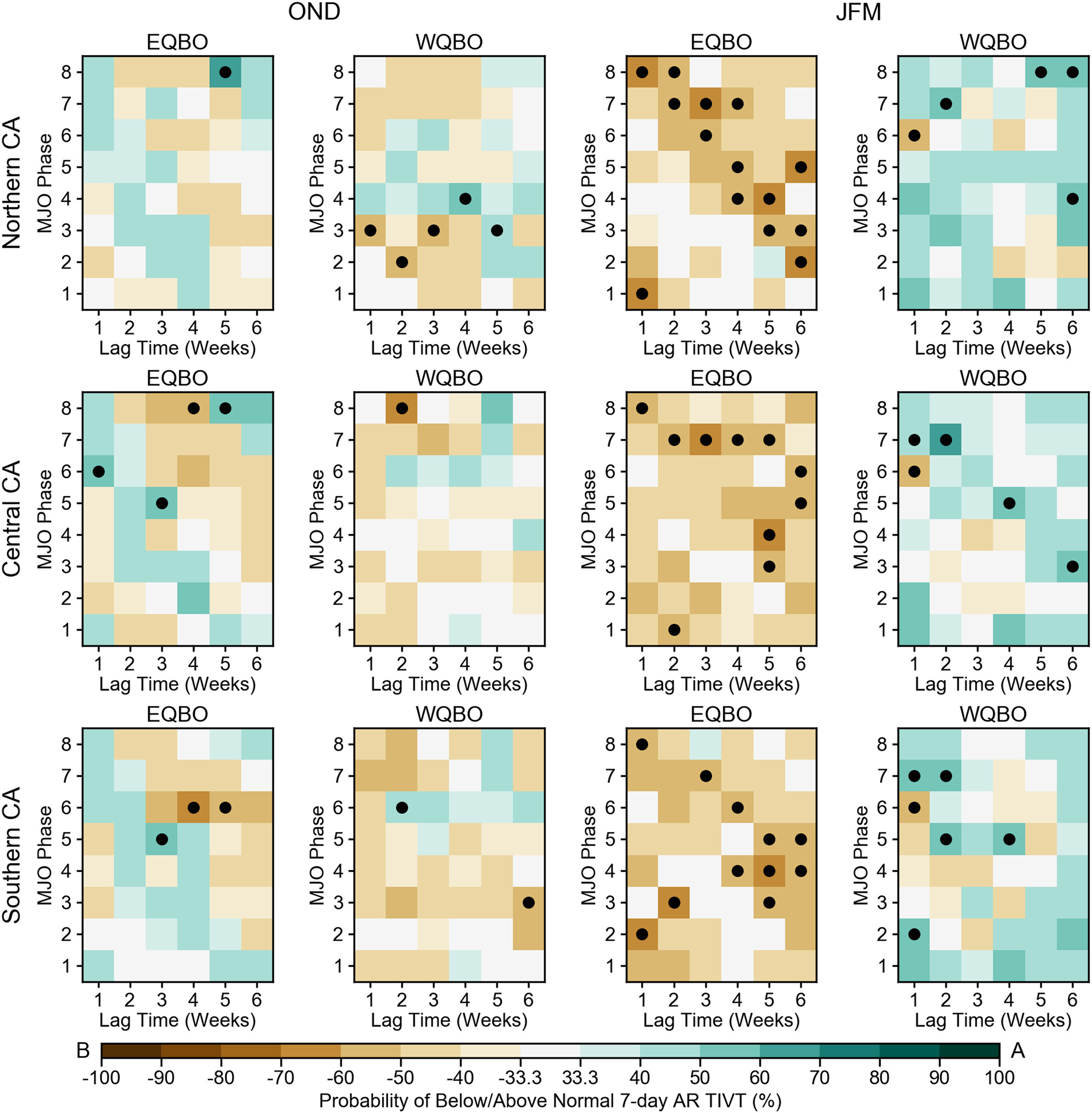
Consistent with previous studies, this paper demonstrates that subseasonal AR activity and precipitation in California are strongly modulated by the MJO and QBO, particularly during winter and early spring [i.e., January–March (JFM)]. There is a tendency toward below-normal AR activity and precipitation following an active MJO and easterly QBO conditions, and above-normal AR activity and precipitation following an active MJO and westerly QBO conditions in JFM. The opposite patterns are generally observed during fall and early winter (OND), but the anomaly signals are weaker and less coherent, especially for AR activity. A composite analysis of outgoing longwave radiation (OLR), 500-hPa geopotential heights, and 250-hPa winds revealed that easterly (westerly) QBO periods in JFM are associated with increased (decreased) MJO activity in the tropical western Pacific, anomalous ridging (troughing) over the Northeast Pacific, and a zonal retraction (extension) of the North Pacific jet. Differences in midlatitude large-scale circulation patterns between easterly QBO and westerly QBO are even more pronounced when the enhanced MJO convection is located over the tropical western Pacific (Phase 7). These findings suggest that the QBO plays an important role in directly modulating MJO activity and modifying MJO-related teleconnections via changes to the background state over the North Pacific.
In order to assess the potential utility of the experimental forecast tool, the authors conducted a skill assessment of probabilistic AR activity and precipitation hindcasts in Northern, Central, and Southern California, as well as two sets of smaller geographical domains. The hindcast skill was quantified by pairing a rigorous cross-validation approach with the ranked probability skill score. On average, the MJO/QBO statistical forecasts showed little or no improvement over climatological reference forecasts. However, certain combinations of MJO/QBO phase, lag time, and season yielded notably higher skill scores, reinforcing the notion of “windows of opportunity” for skillful subseasonal predictions. These forecasts of opportunity were predominantly associated with easterly QBO in JFM and FMA. Given the strong tendency for decreased AR activity and precipitation following easterly QBO in JFM and FMA, this forecast tool may provide useful information for water resource managers and dam operators during the latter half of the wet season. Furthermore, a lack of degradation of forecast skill for the smaller domains suggests that a more targeted application of this forecasting approach at the watershed scale is feasible. CW3E plans to launch this new experimental subseasonal forecast tool on its public S2S website (/s2s_forecasts/) next winter.
Figure 1: Figure 2 from Castellano et al. (2023). Probability matrices illustrating the weeks 1–6 lagged probability of below-normal (brown shading) or above-normal (green shading) AR-TIVT for all MJO/QBO phase configurations during OND (left) and JFM (right) in Northern California (top), Central California (middle), and Southern California (bottom). White squares indicate that the near-normal category has the highest probability. The black dots denote statistically significant probabilities of below- or above-normal AR-TIVT (based on the bootstrapping analysis).
Figure 2: Figure 11 from Castellano et al. (2023). Experimental forecast product showing the probability of above-normal (green arrows) and below-normal (brown arrows) precipitation in Northern California during the 6 weeks following an MJO in Phase 7 and easterly QBO conditions on 3 February 2015. The gray bars indicate the climatological normal range of values (i.e., the intertercile range) for a given calendar period. The climatological mean and median values are denoted by the horizontal black line and black dot, respectively. Above-normal values are greater than the upper tercile of climatology, and below-normal values are less than the lower tercile of climatology.
Castellano, C. M., DeFlorio, M. J., Gibson, P. B., Delle Monache, L., Kalansky, J. F., Wang, J., et al. (2023). Development of a statistical subseasonal forecast tool to predict California atmospheric rivers and precipitation based on MJO and QBO activity. Journal of Geophysical Research: Atmospheres, 128, e2022JD037360. doi: https://doi.org/10.1029/2022JD037360


