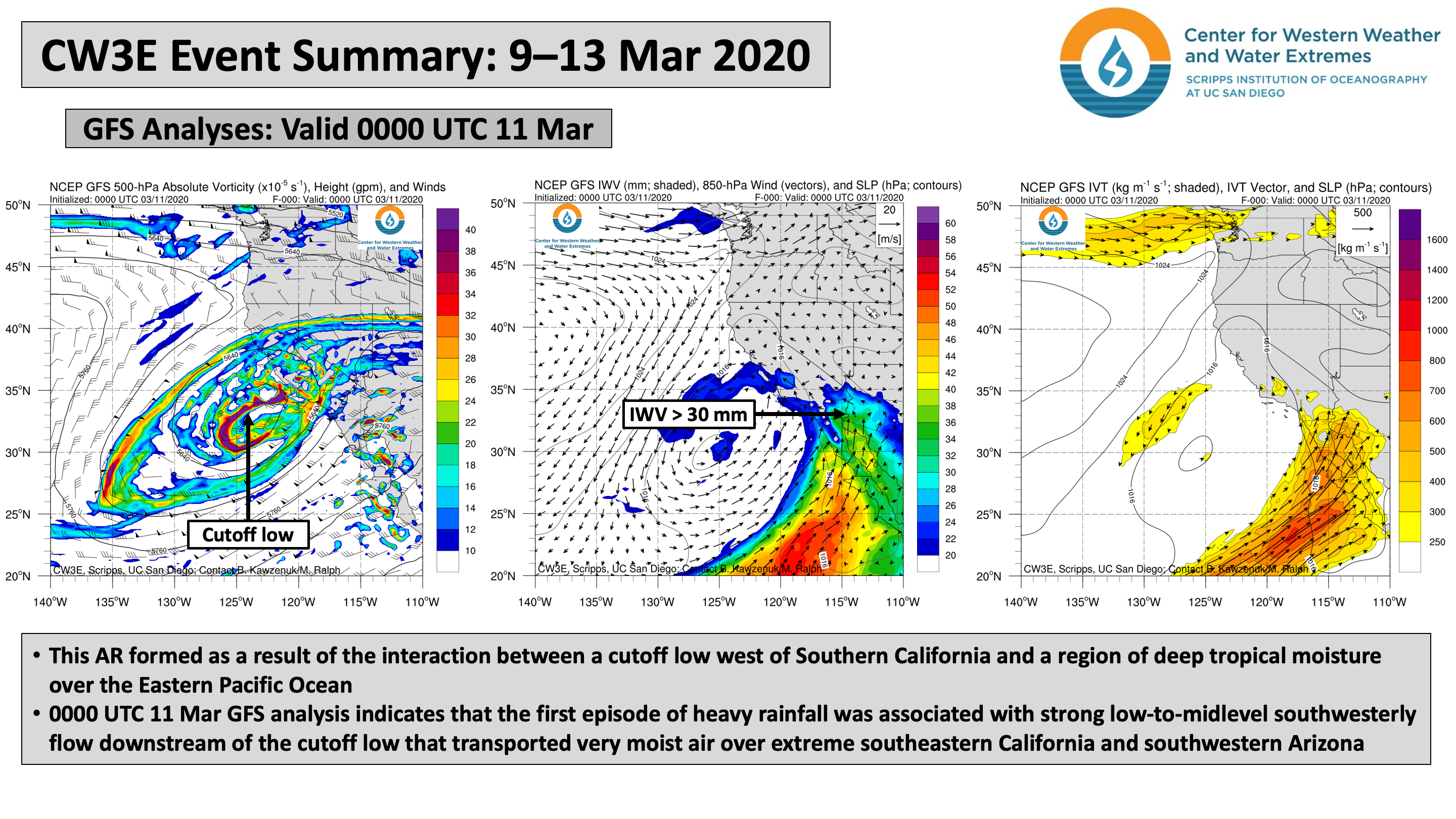
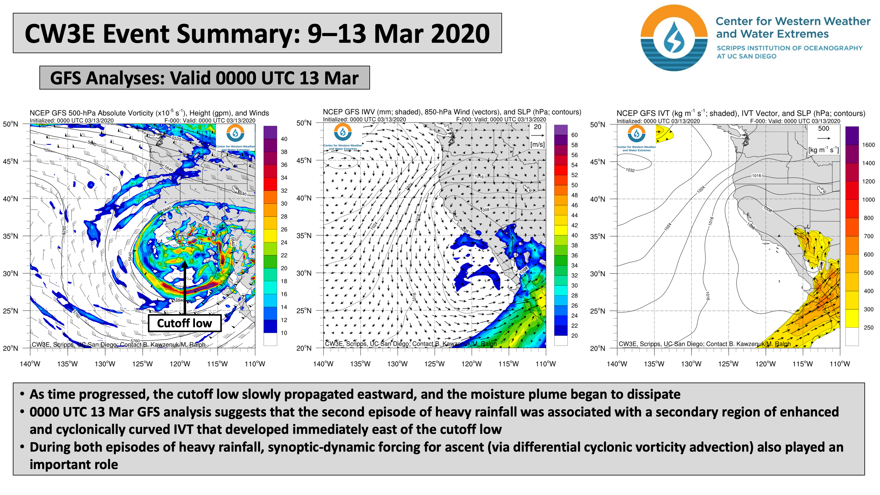
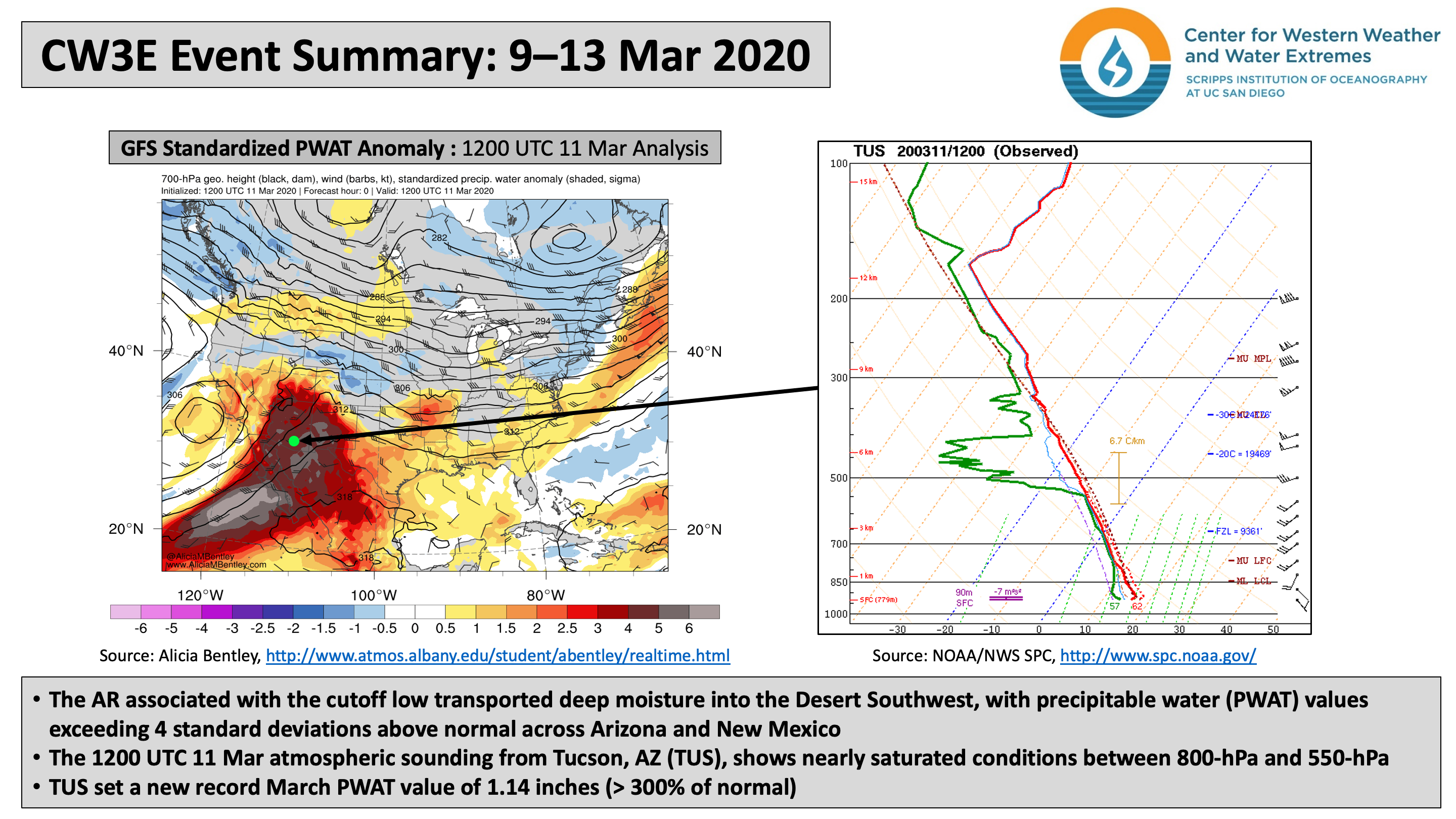
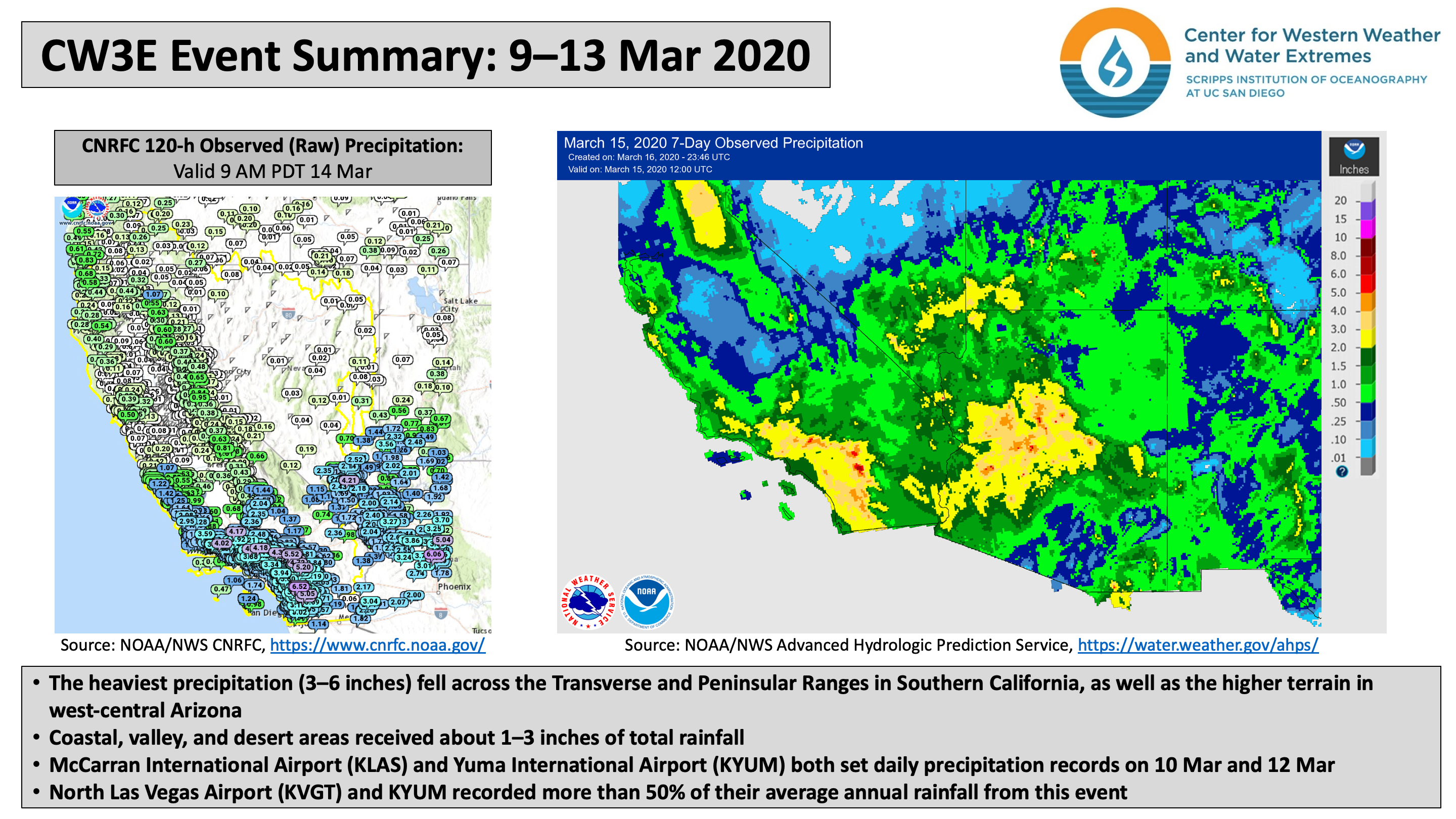
CW3E Publication Notice
Detection Uncertainty Matters for Understanding Atmospheric Rivers
April 2, 2020
Indiana University assistant professor Dr. Travis O’Brien and co-authors recently published an article in the Bulletin of the American Meteorological Society (BAMS) titled “Detection Uncertainty Matters for Understanding Atmospheric Rivers”. Several members of CW3E contributed as co-authors to this work, including Christopher Castellano, Mike DeFlorio, Brian Kawzenuk, Allison Michaelis, and Zhenhai Zhang. This paper builds upon earlier atmospheric river detection tools (ARDT) work at CW3E: i.e., some of the ARDTs studied in ARTMIP were developed by CW3E scientists (Rutz et al. 2014; Mon. Wea. Rev. and Gershunov et al. 2017; Geophys. Res. Lett.), and CW3E scientists led or contributed to recent work comparing ARDTs [Shields et al. (2018; Geosci Model Dev.), Rutz et al. (2019; JGR-A) and Ralph et al. (2019; Clim. Dynam.) – see /publications/ for links to these papers].
The purpose of this BAMS article is to summarize the 3rd ARTMIP (Atmospheric River Tracking Method Intercomparison Project) Workshop (held during October 2019 at Lawrence Berkeley National Laboratory [LBL]), and to highlight current and emerging scientific endeavors related to atmospheric river (AR) detection and tracking. Many CW3E research and product development efforts rely on accurate and robust detection of ARs in order to meet the needs of our stakeholders at both the California Department of Water Resources and U.S. Army Corps of Engineers.
The ARTMIP project was created in order to facilitate comparisons between AR detection and tracking schemes across different research groups. Quantifying the uncertainty associated with AR detection and tracking methods is vital for interpreting observational and modeling studies within the AR research and experimental forecast product development community. For more information on ARTMIP visit http://www.cgd.ucar.edu/projects/artmip/, this site also includes a list of publications generated by and associated with ARTMIP, available here.
The 1st ARTMIP Workshop was held in May 2017 at CW3E, and the 2nd ARTMIP Workshop was held in April 2018 in Gaithersburg, MD. The 3rd ARTMIP Workshop contained presentations from researchers across the AR community, and also included an interactive session where researchers hand-identified AR objects using LBL’s ClimateNet machine learning software. A comparison between expert AR identifications is shown in Figure 1, along with the background integrated water vapor field for that day.
The major outcomes of the workshop were to expand the research topics to be included in the ARTMIP project going forward, including reanalysis sensitivity studies and paleoclimate studies, and to continue to provide the AR research community with the various AR detection catalogues included as part of the ARTMIP project.
Figure 1: Comparison of expert AR identifications from 06 September 2009 of a 25km CAM5 Atmospheric Model Intercomparison Project simulation. The background field shows integrated water vapor, and the green contours show outlines of ARs identified by 15 ARTMIP participants using Lawrence Berkeley National Laboratory’s ClimateNet machine learning software.
O’Brien, T.A., A.E. Payne, C.A. Shields, J. Rutz, S. Brands, C. Castellano, J. Chen, W. Cleveland, M.J. DeFlorio, N. Goldenson, I. Gorodetskaya, H.I. Díaz, K. Kashinath, B. Kawzenuk, S. Kim, M. Krinitskiy, J.M. Lora, B. McClenny, A. Michaelis, J. O’Brien, C.M. Patricola, A.M. Ramos, E.J. Shearer, W. Tung, P. Ullrich, M.F. Wehner, K. Yang, R. Zhang, Z. Zhang, and Y. Zhou, 2020: Detection Uncertainty Matters for Understanding Atmospheric Rivers. Bull. Amer. Meteor. Soc., 0, https://doi.org/10.1175/BAMS-D-19-0348.1