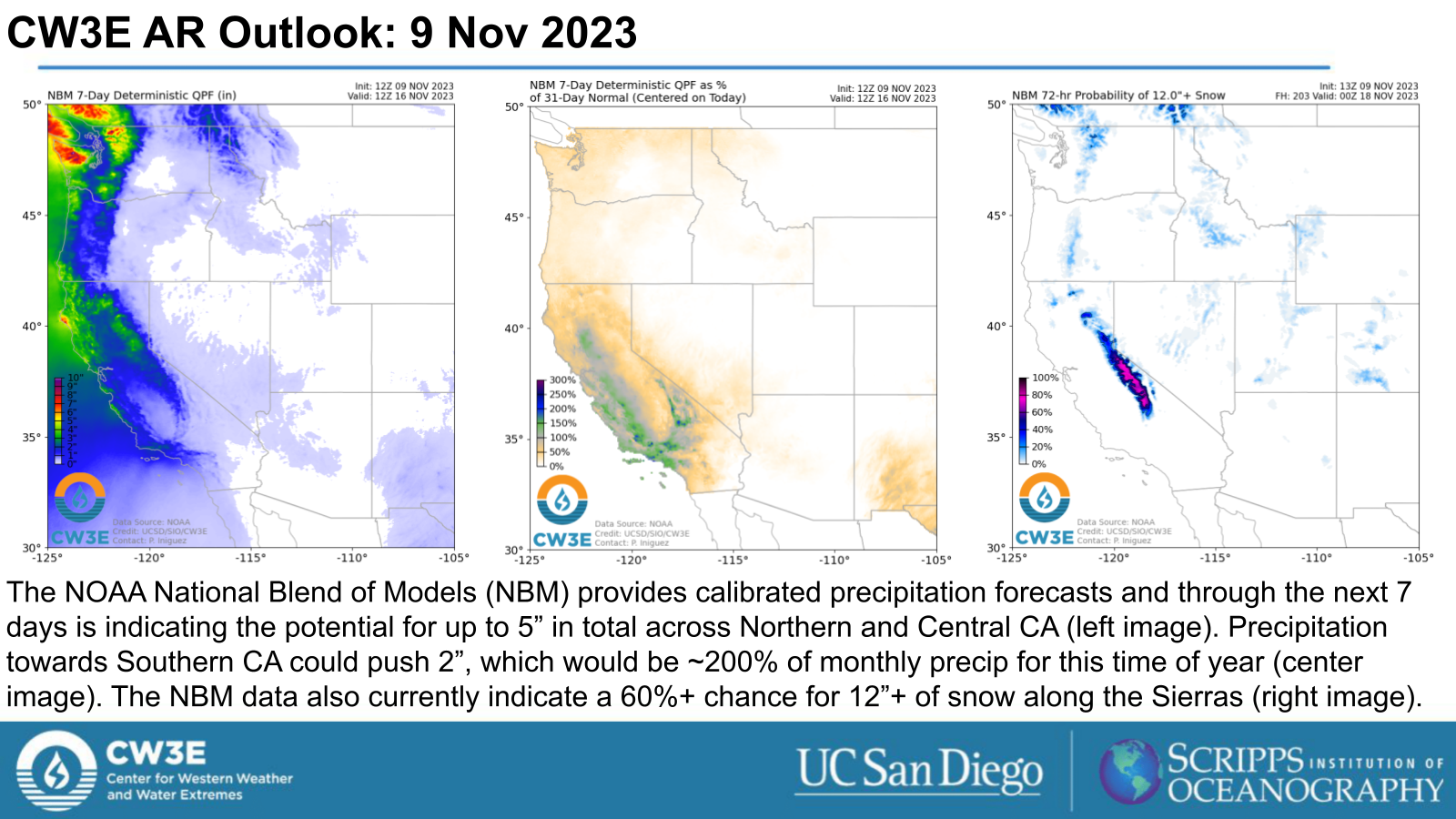
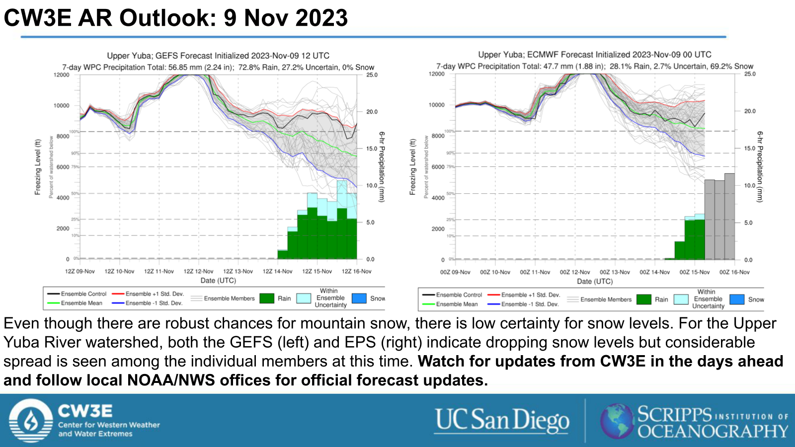
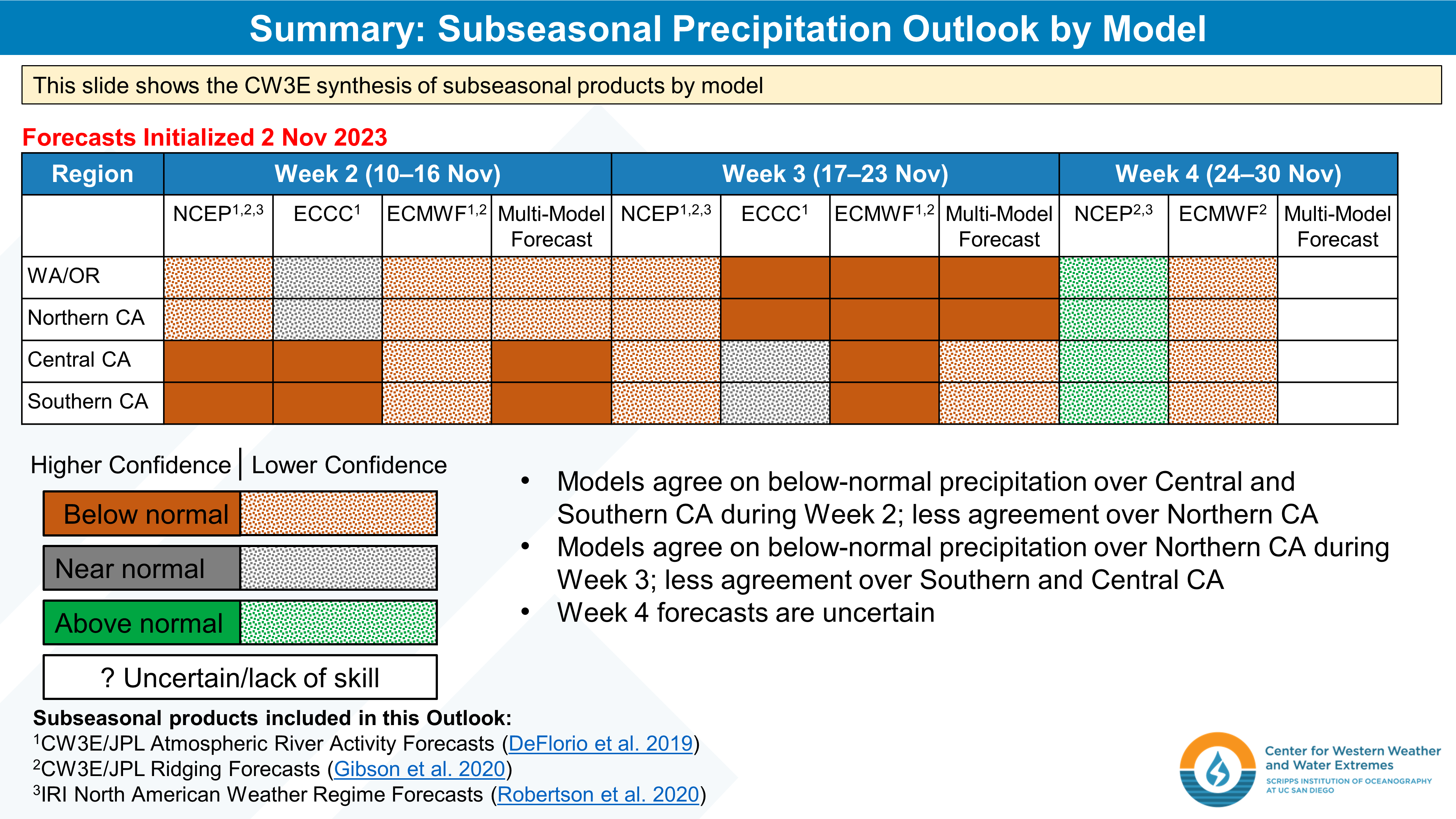
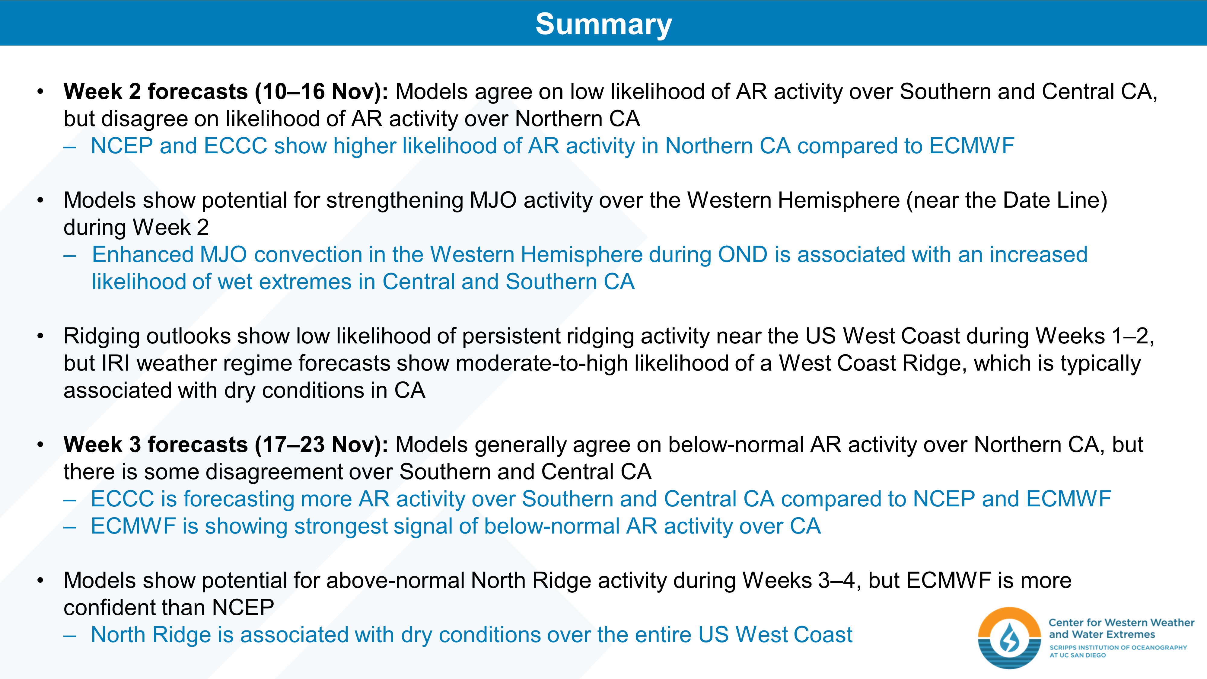
CW3E Atmospheric River Outlook: 9 Nov 2023

CW3E AR Update: 9 November 2023 Outlook

November 9, 2023

Click here for a pdf of this information.

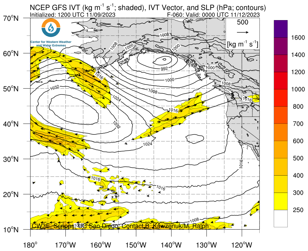
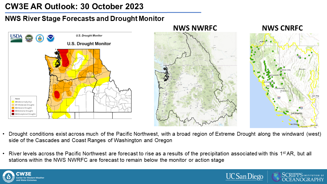
Potential Atmospheric River to Impact the West Coast Next Week

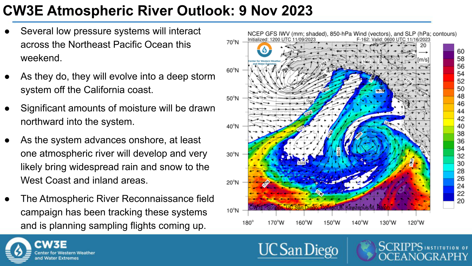
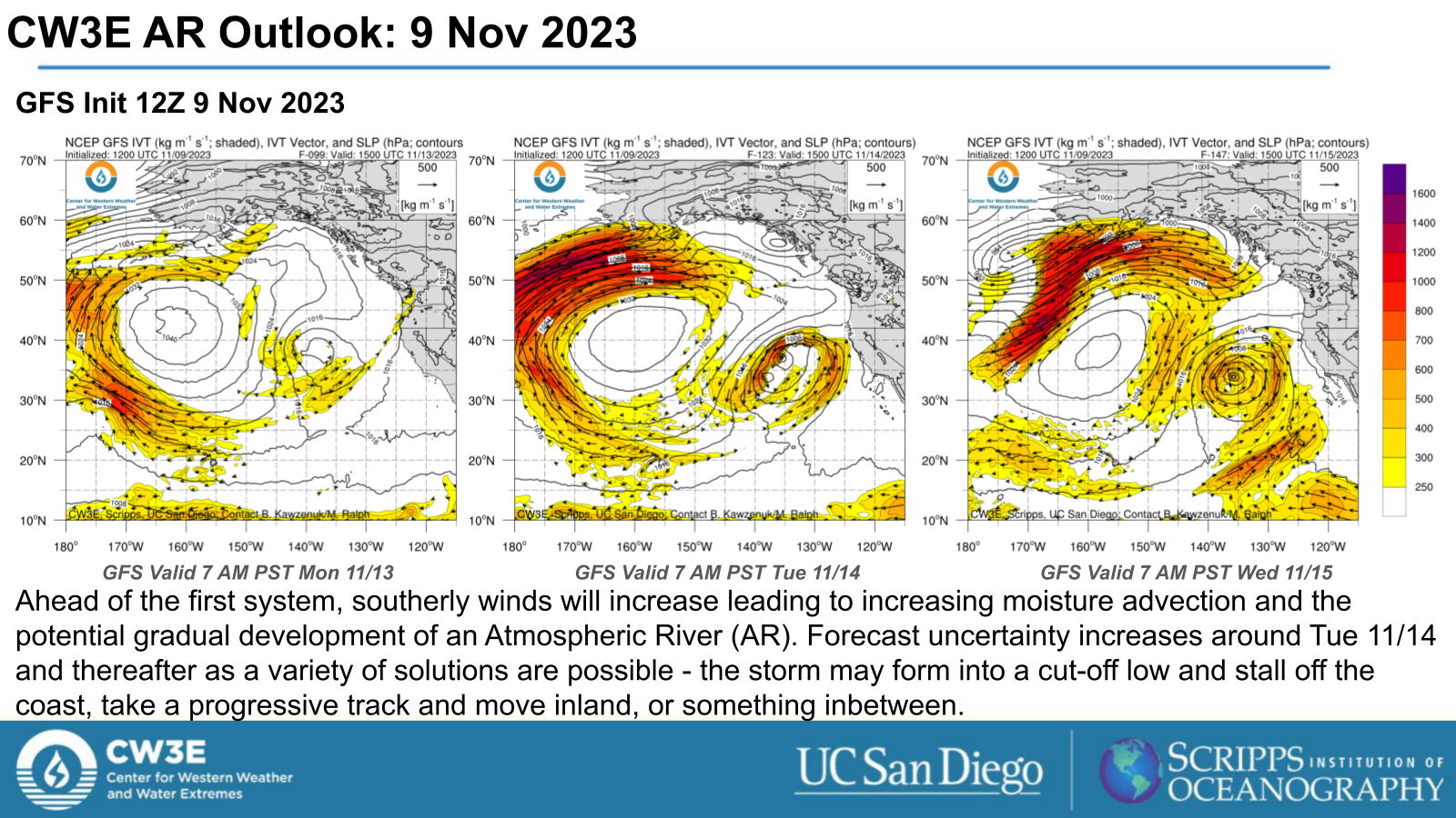
  • Several low pressure systems will interact across the Northeast Pacific Ocean this weekend.
  • As they do, they will evolve into a deep storm system off the California coast.
  • Significant amounts of moisture will be drawn northward into the system.
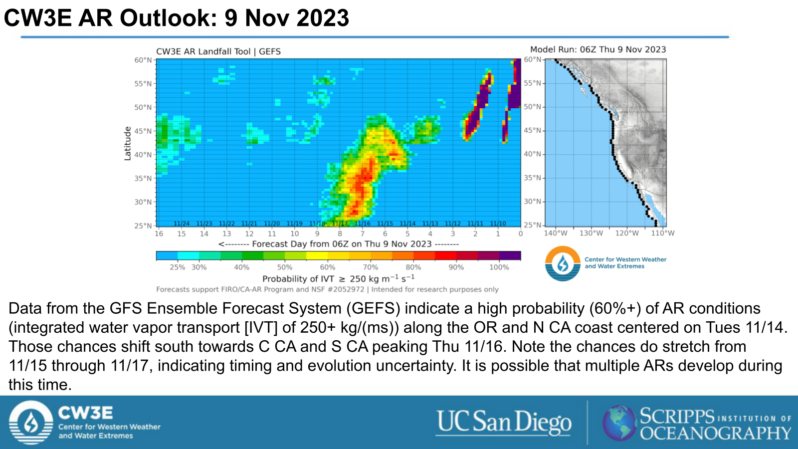
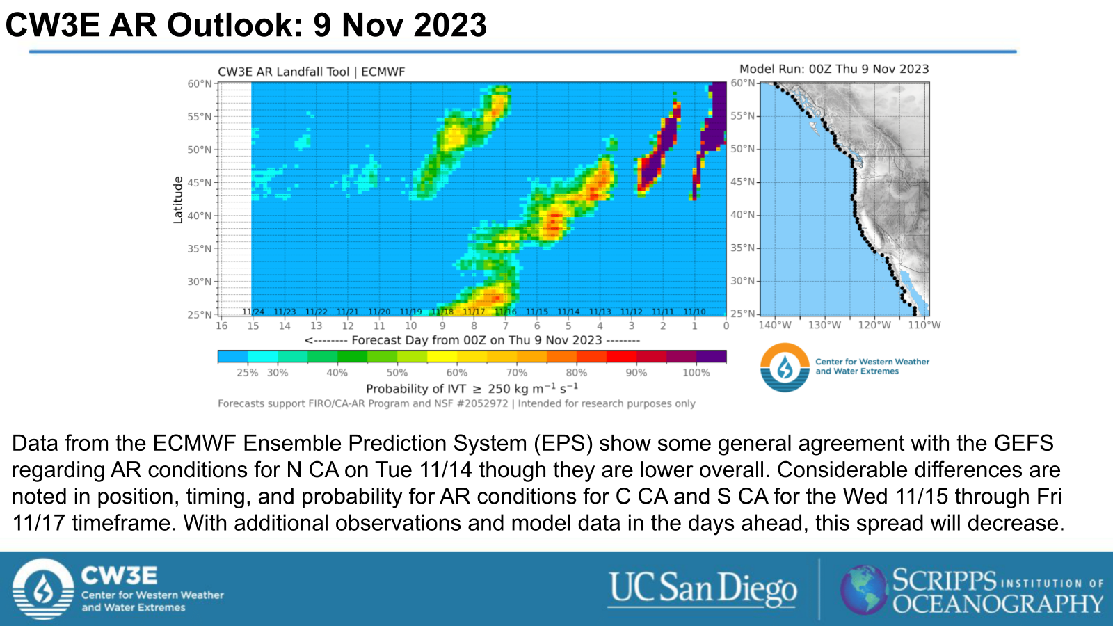
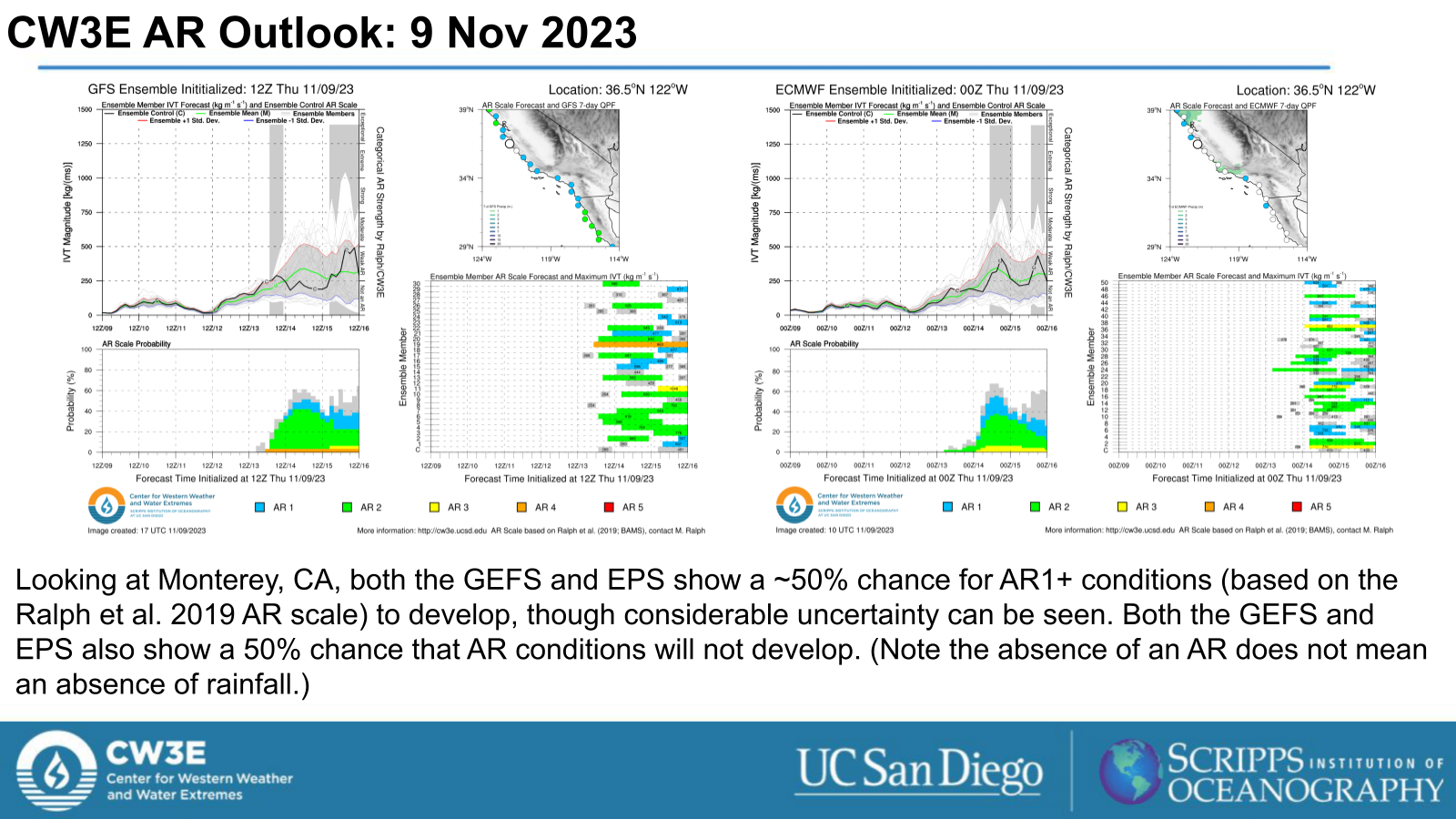
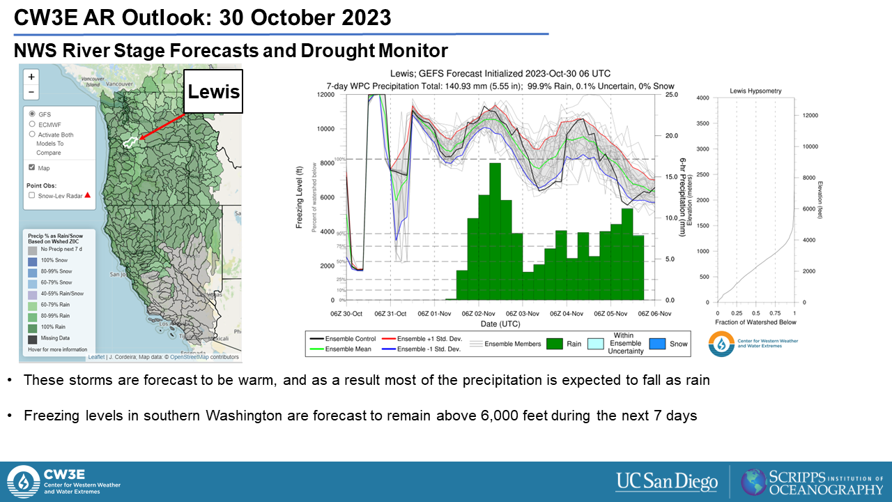
  • As the system advances onshore, at least one atmospheric river will develop and very likely bring widespread rain and snow to the West Coast and inland areas.
  • The Atmospheric River Reconnaissance field campaign has been tracking these systems and is planning sampling flights coming up.
  • Watch for updates from CW3E in the days ahead and follow local NOAA/NWS offices for official forecast updates.

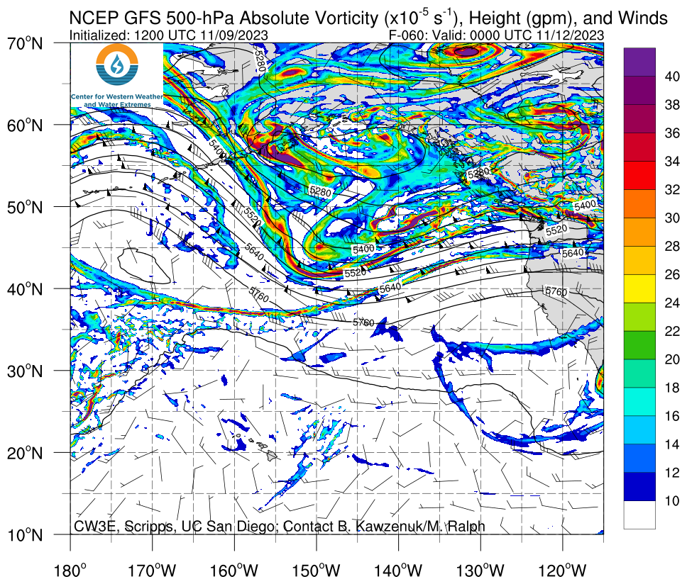
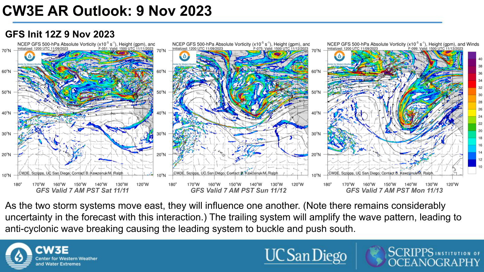
Click images to see loops of GFS IVT and 500 hPa Vorticity forecasts

Valid 0000 UTC 12 November – 0000 UTC 17 November 2023


Summary provided by P. Iniguez, C. Castellano, M. Steen, and S. Bartlett; 9 November 2023

To sign up for email alerts when CW3E post new AR updates click here.

*Outlook products are considered experimental

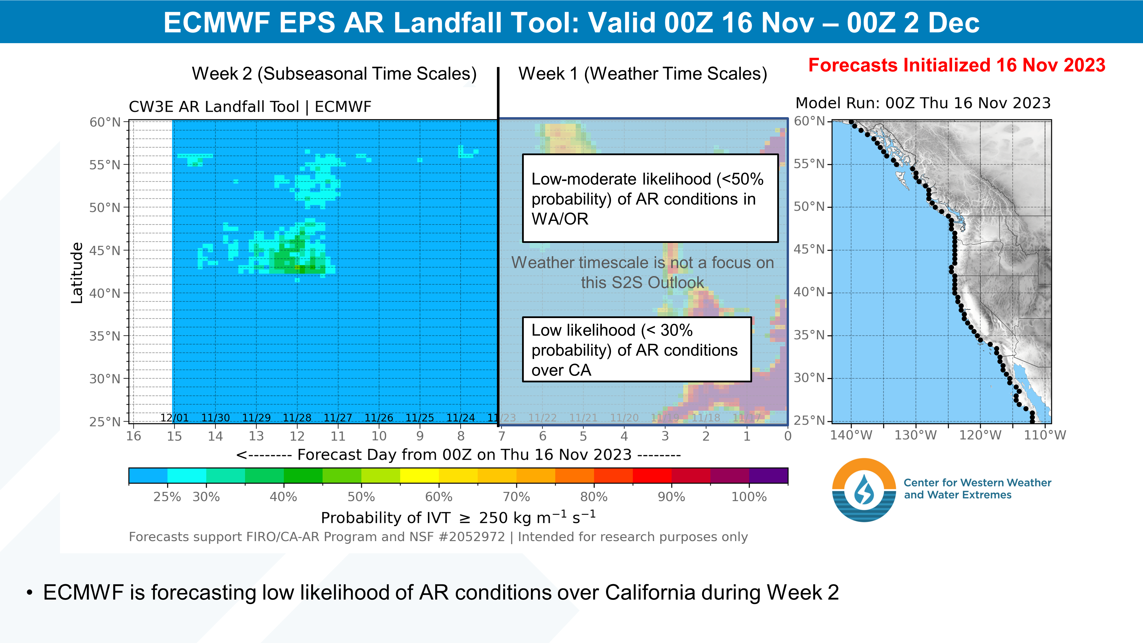
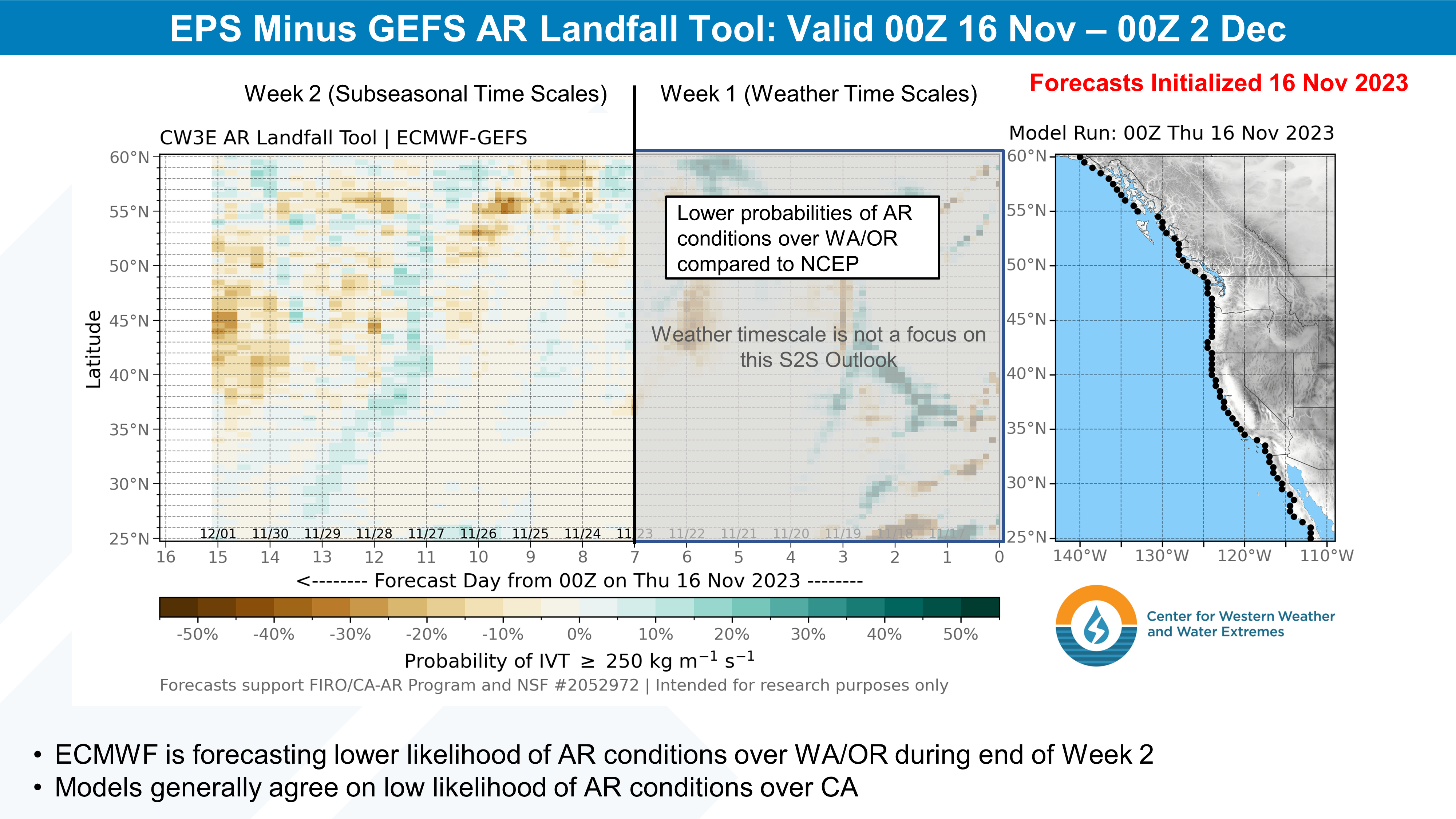
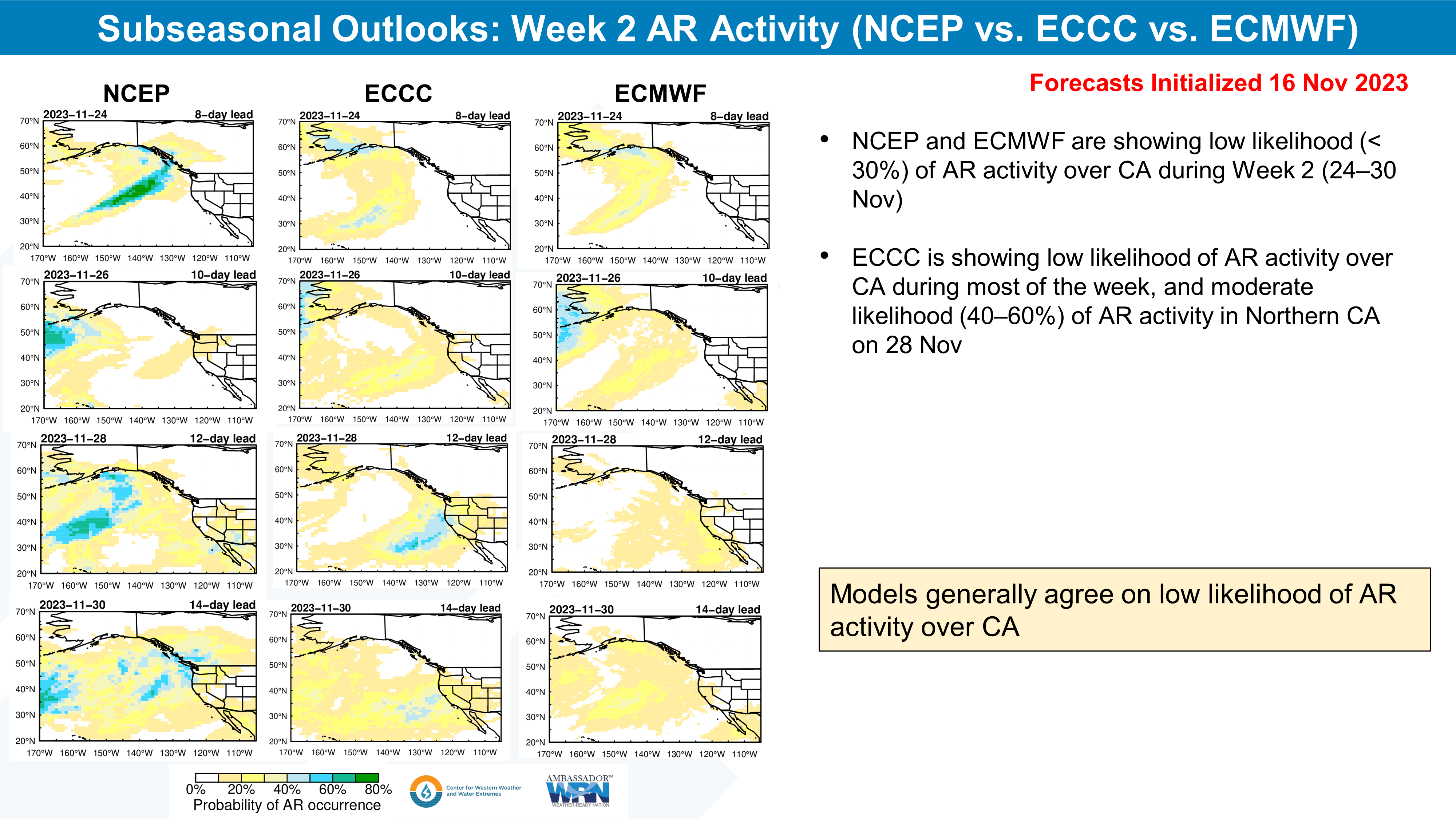
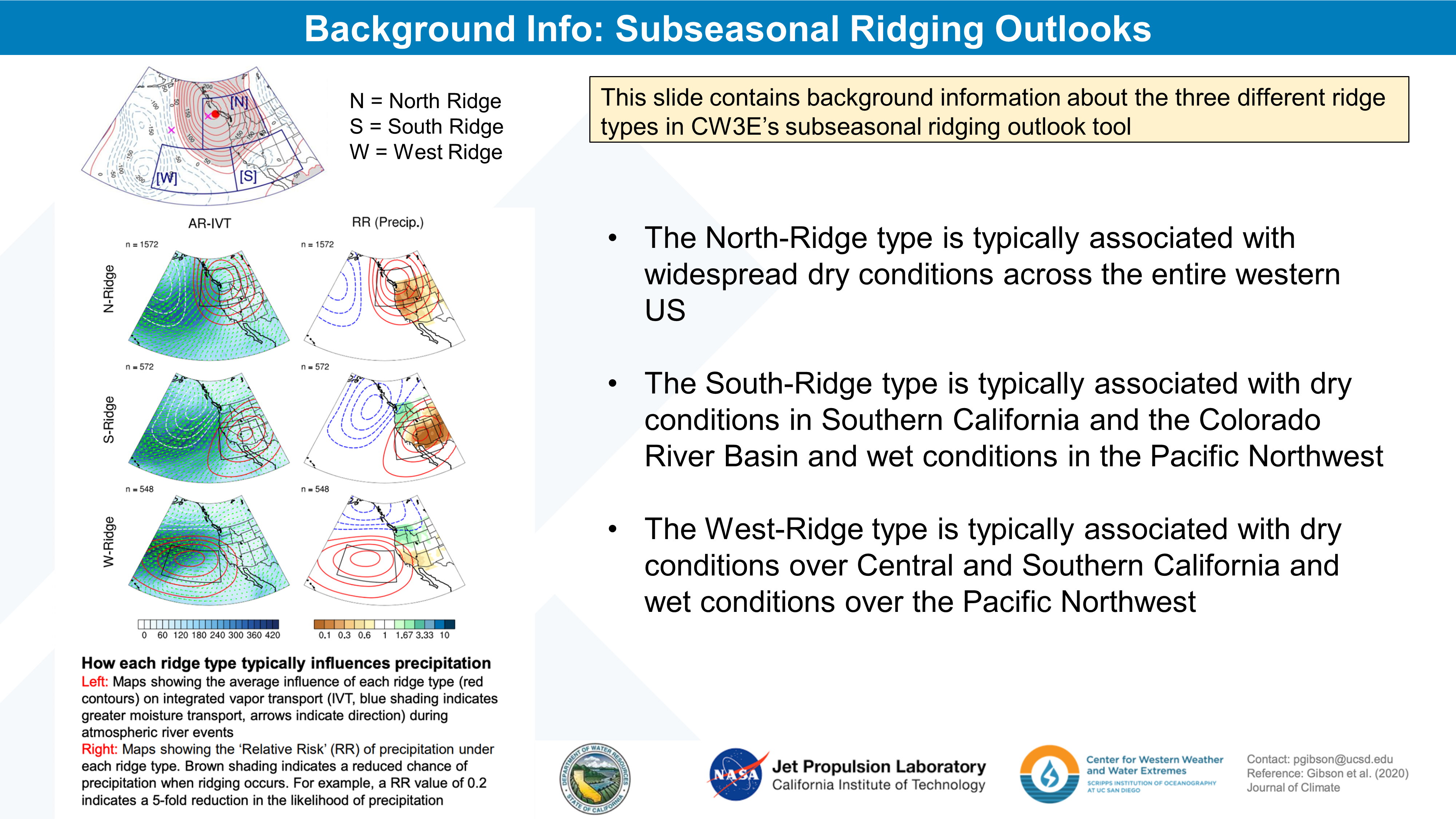
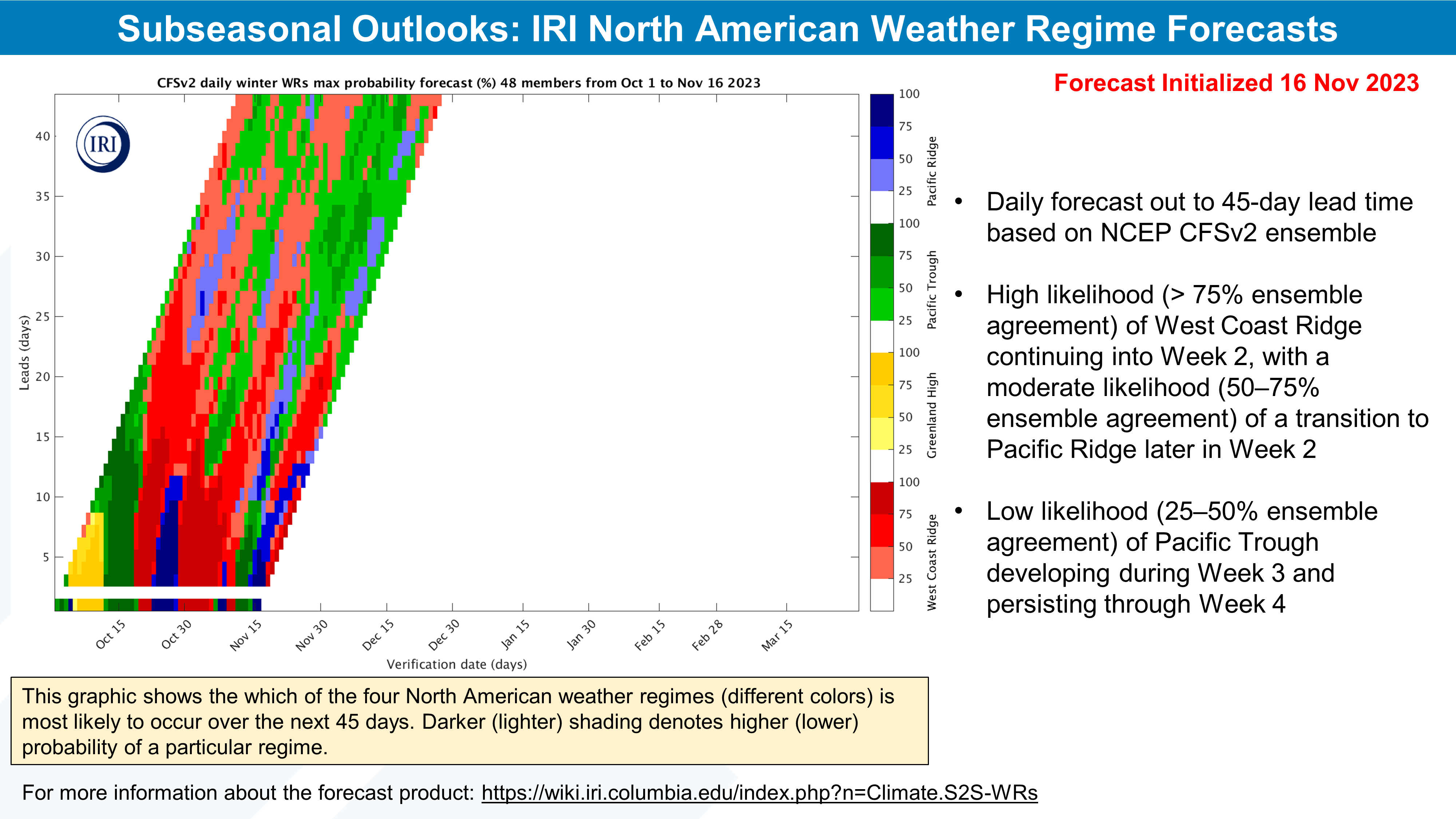
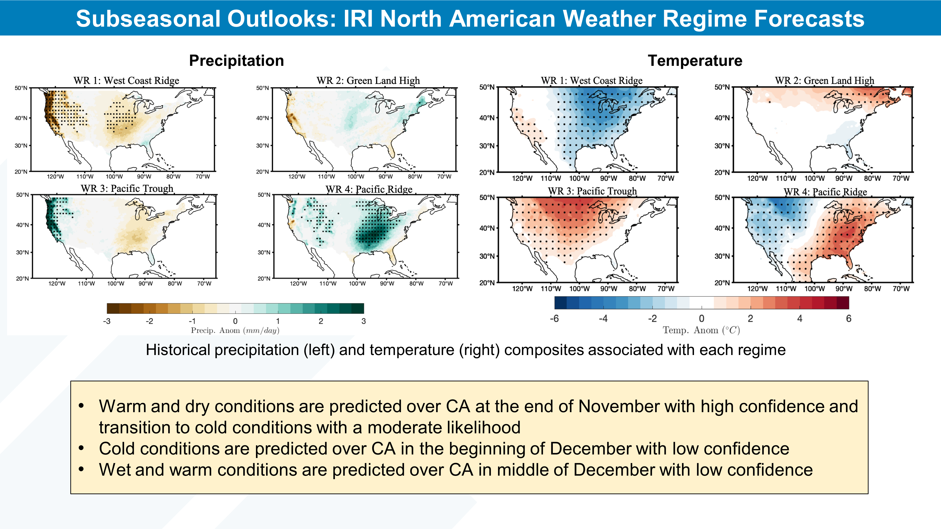
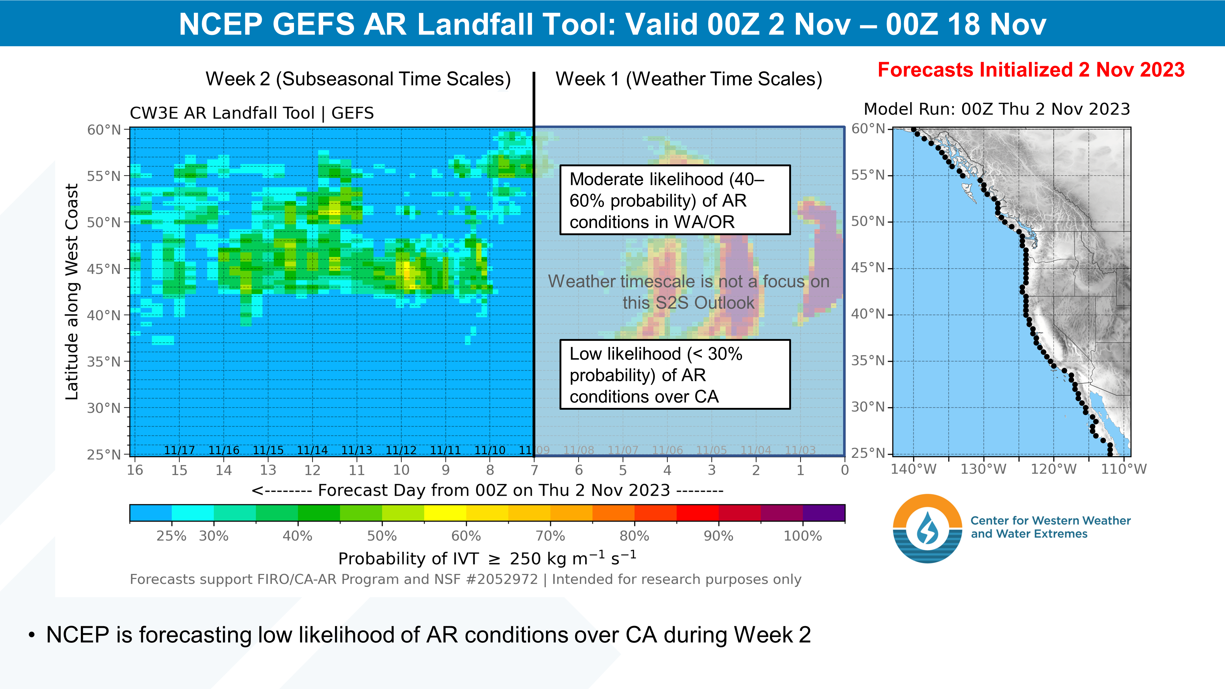
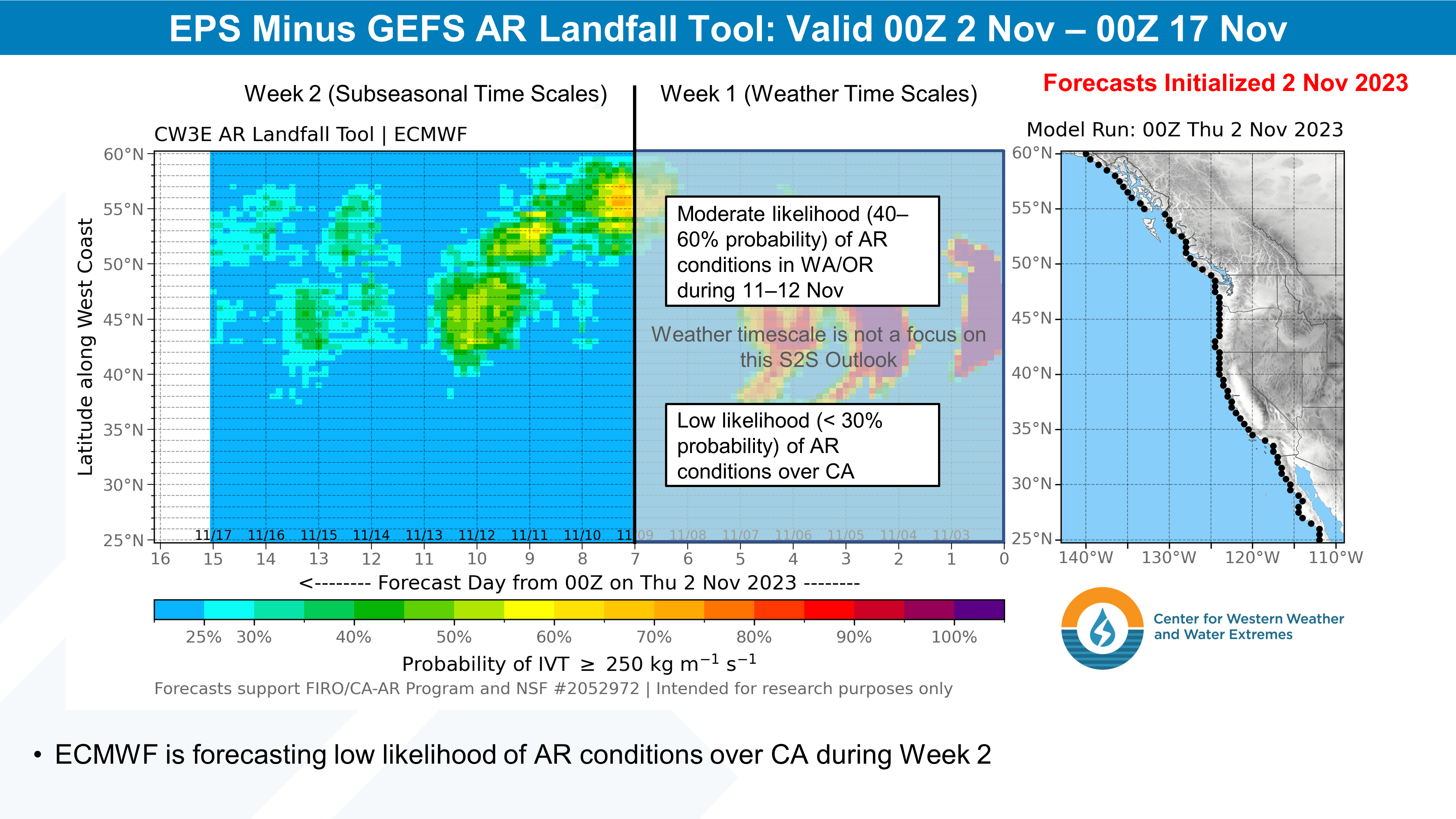
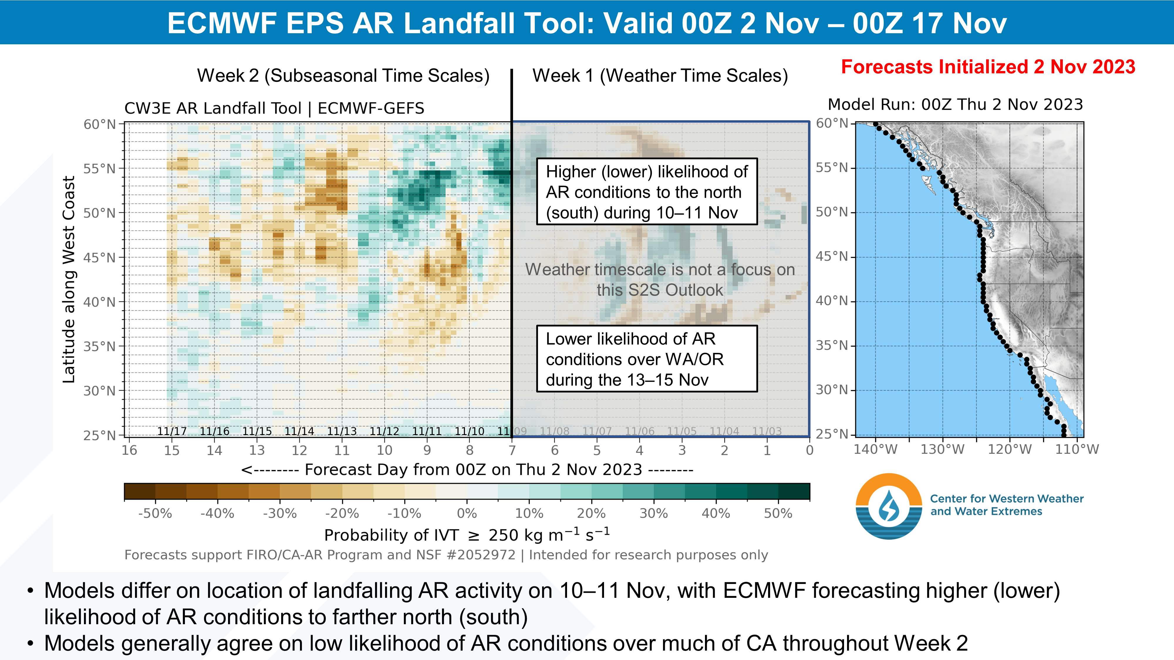
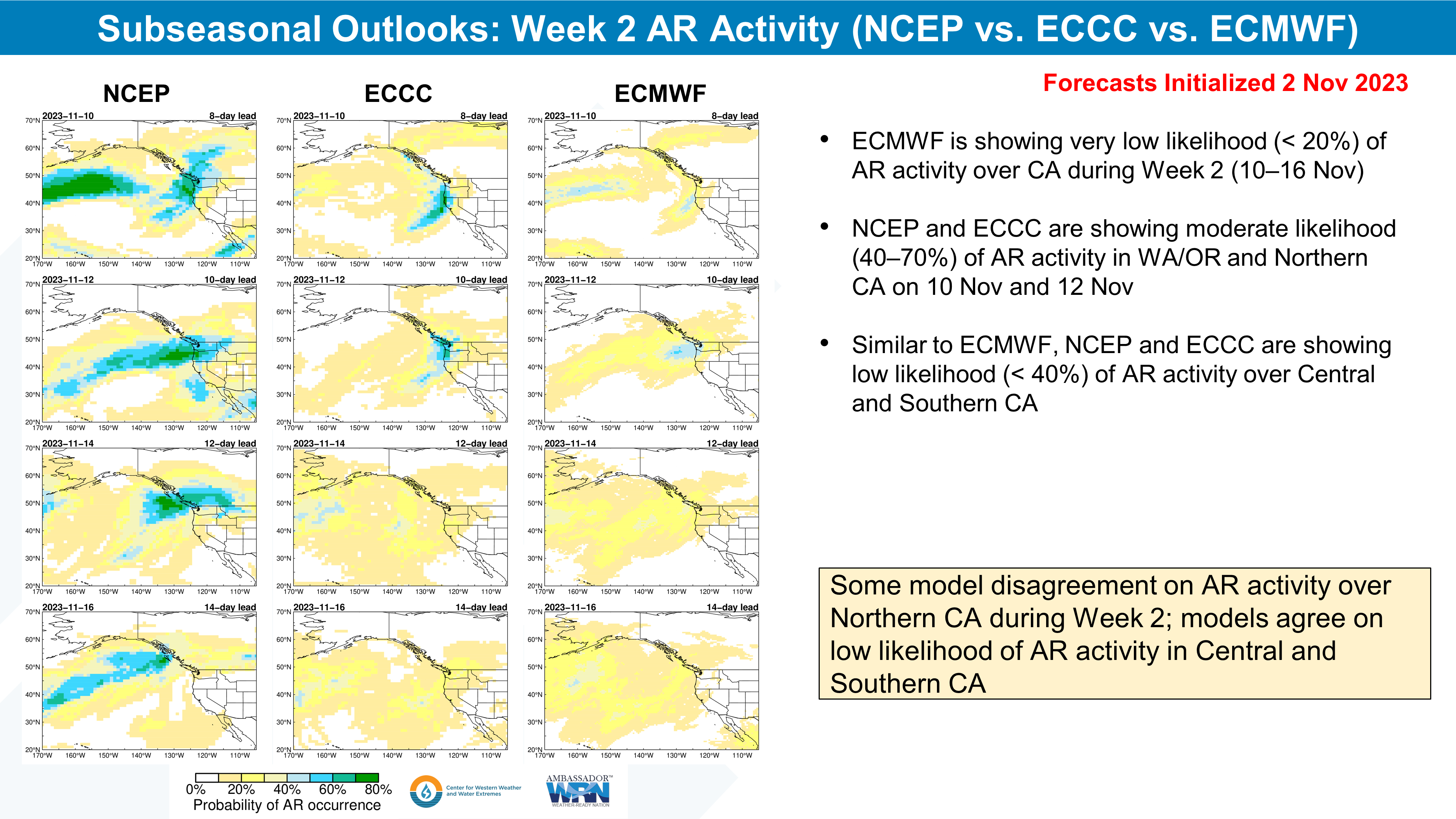
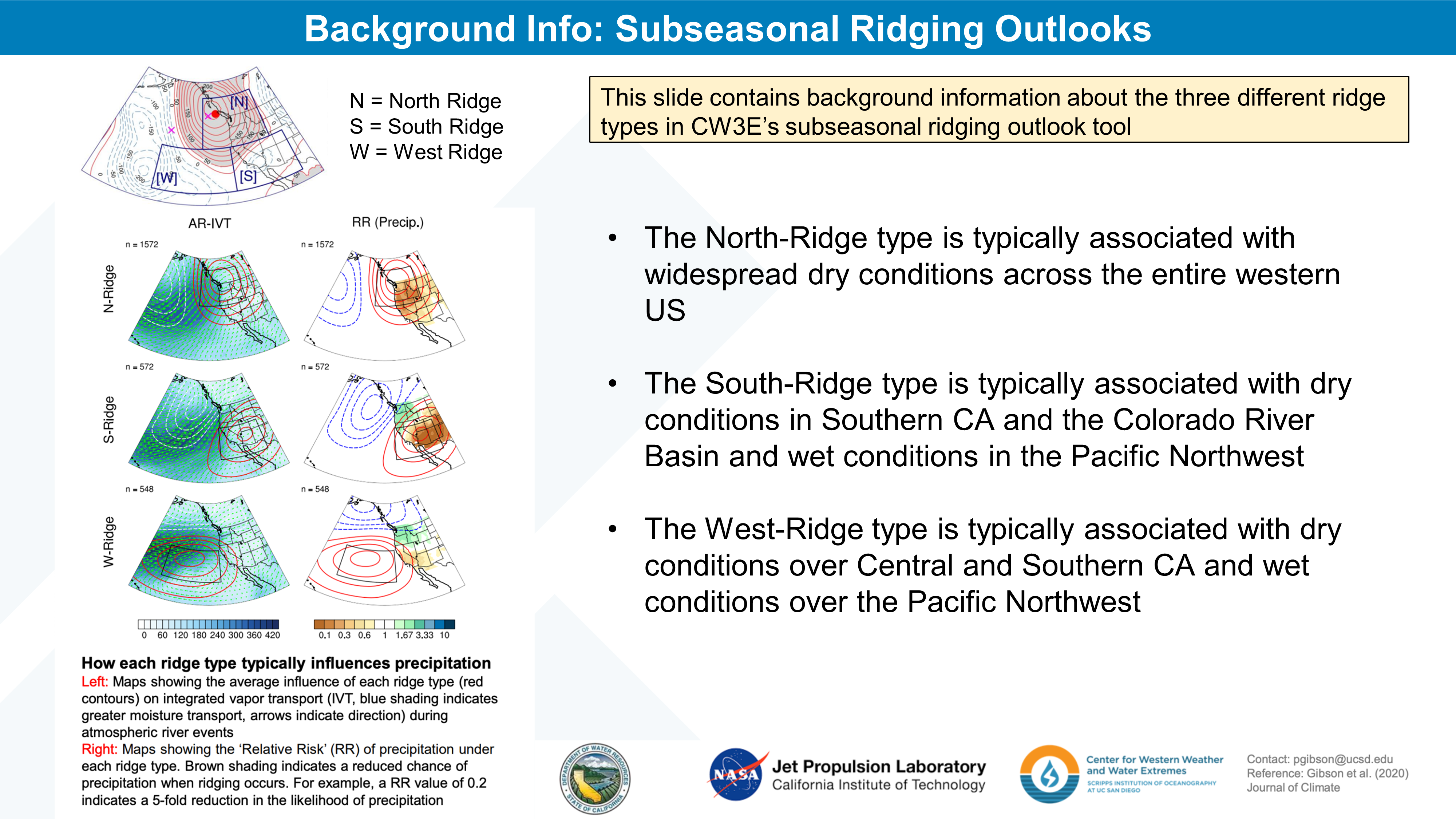
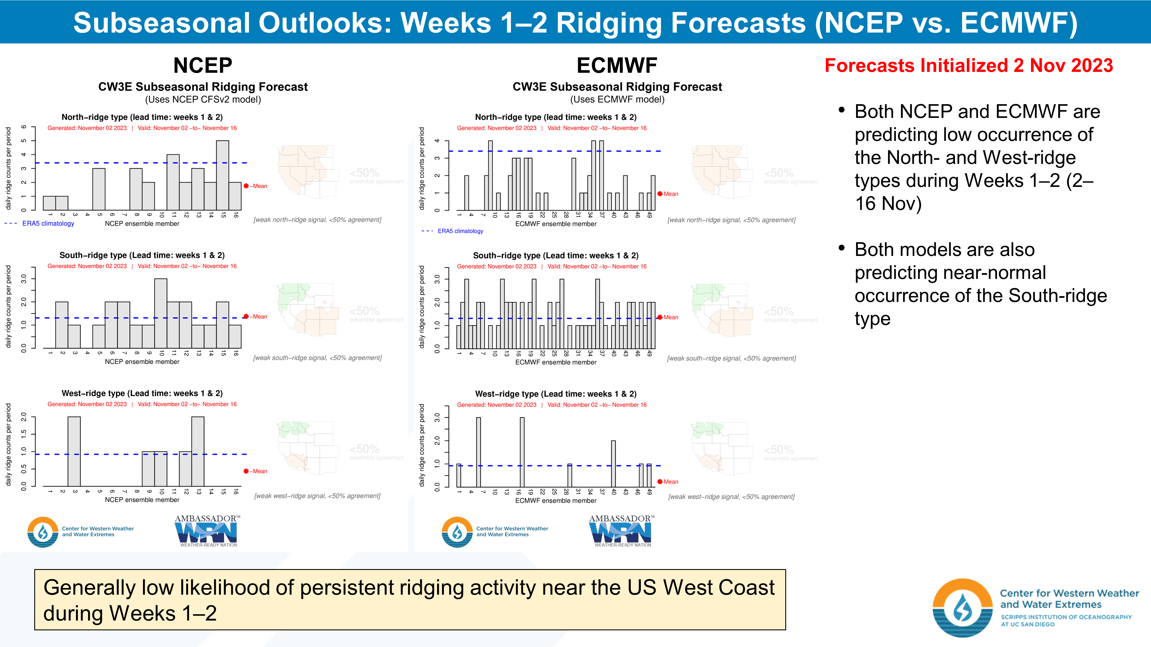
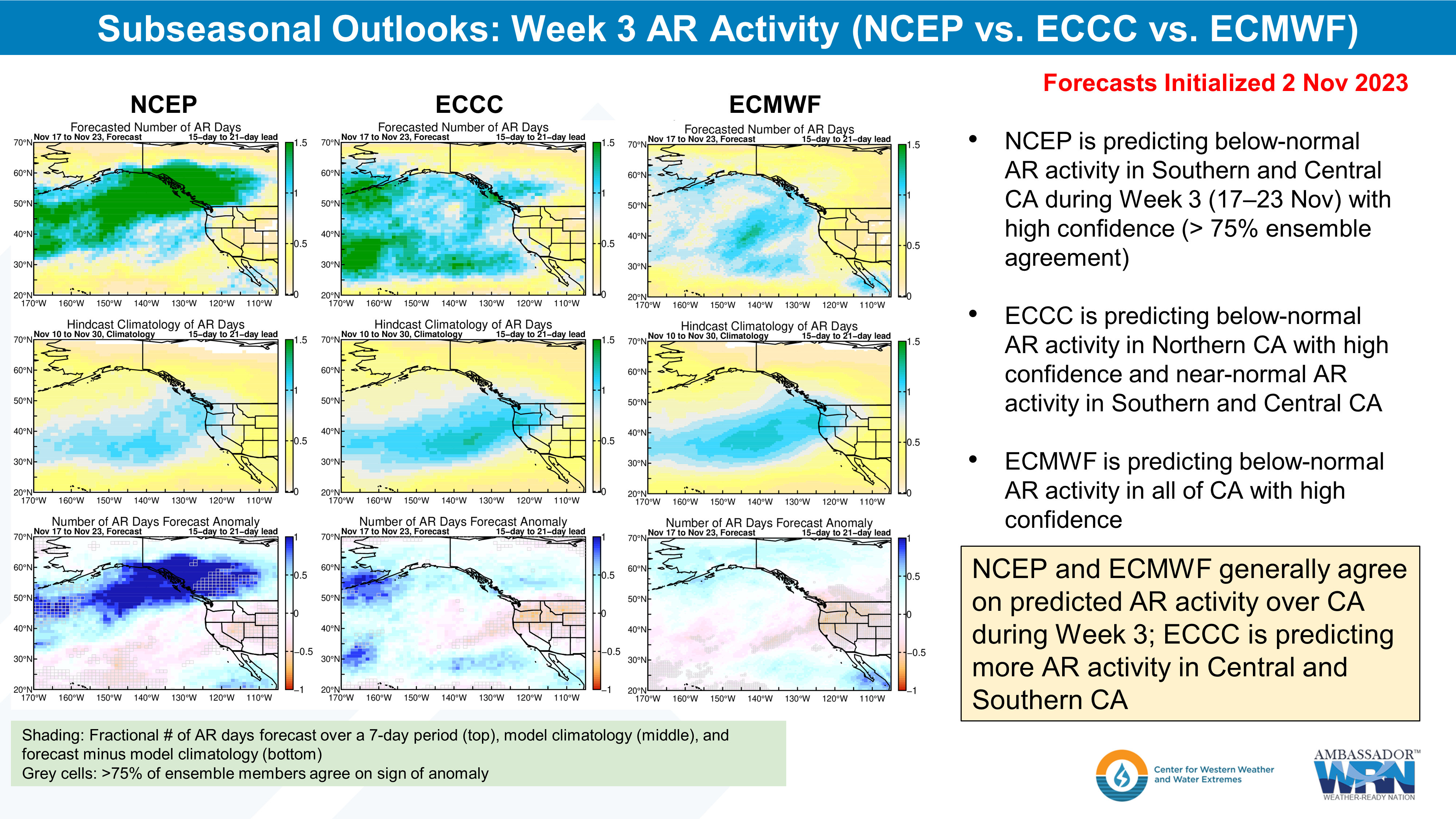
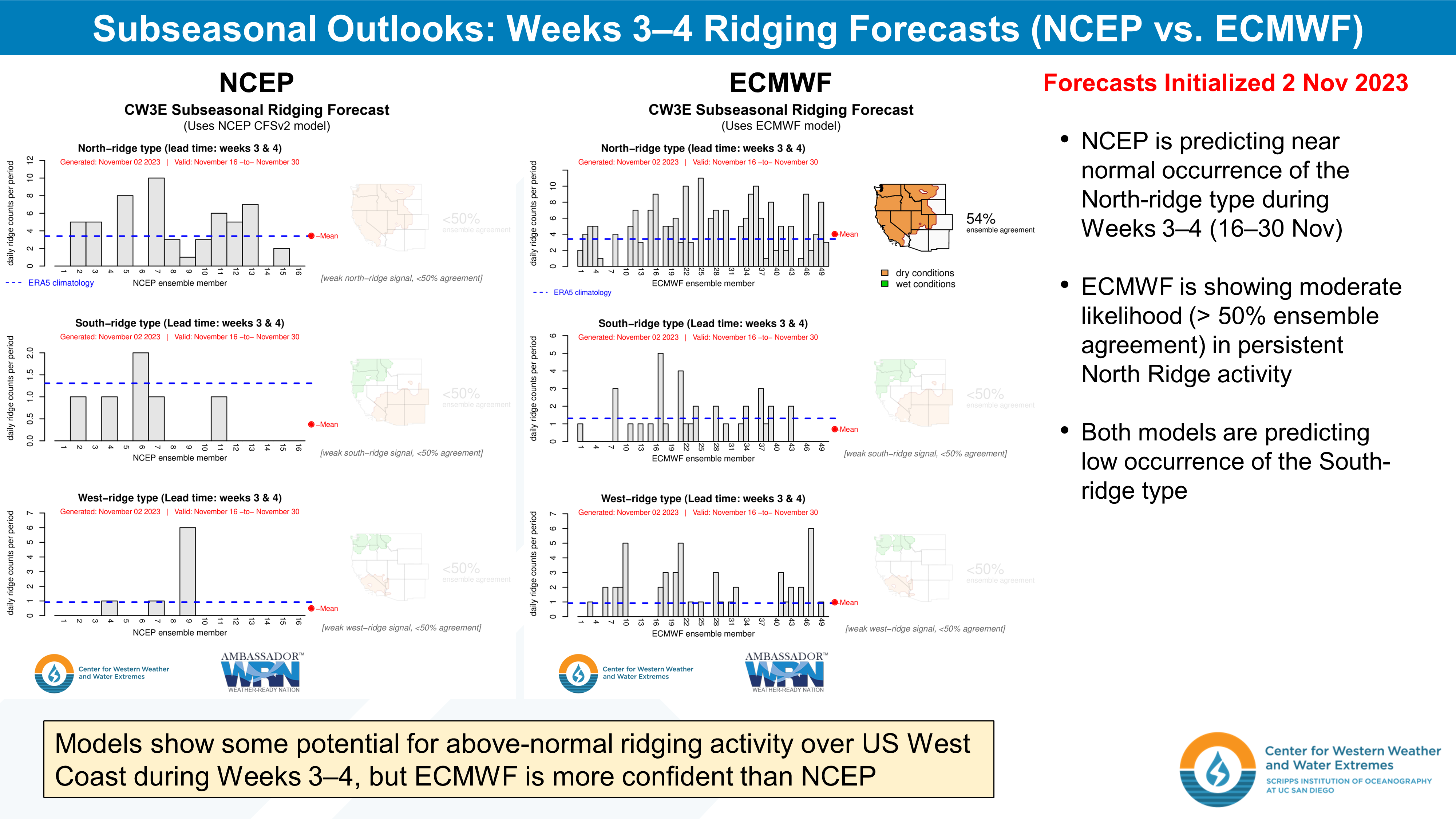
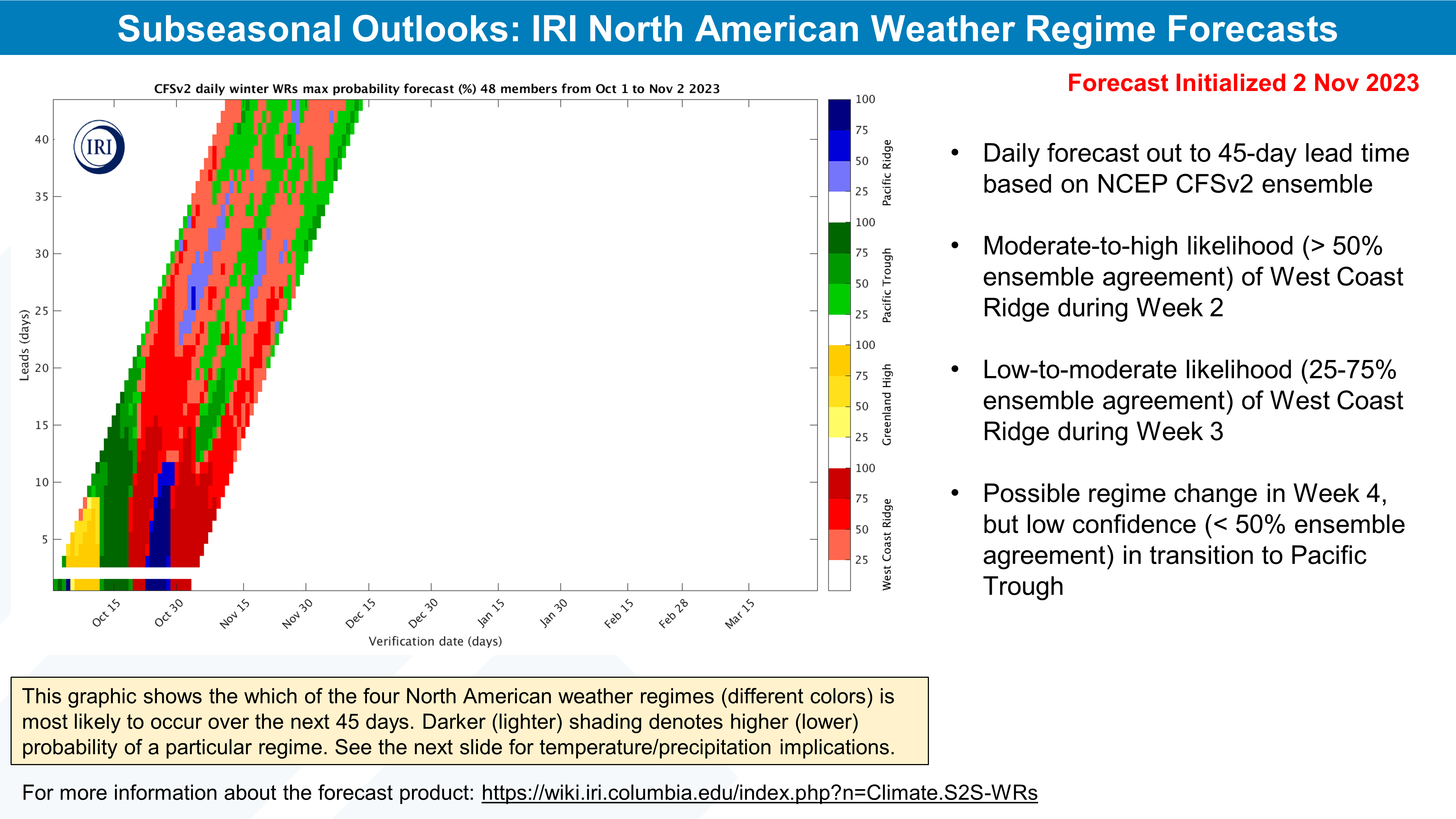
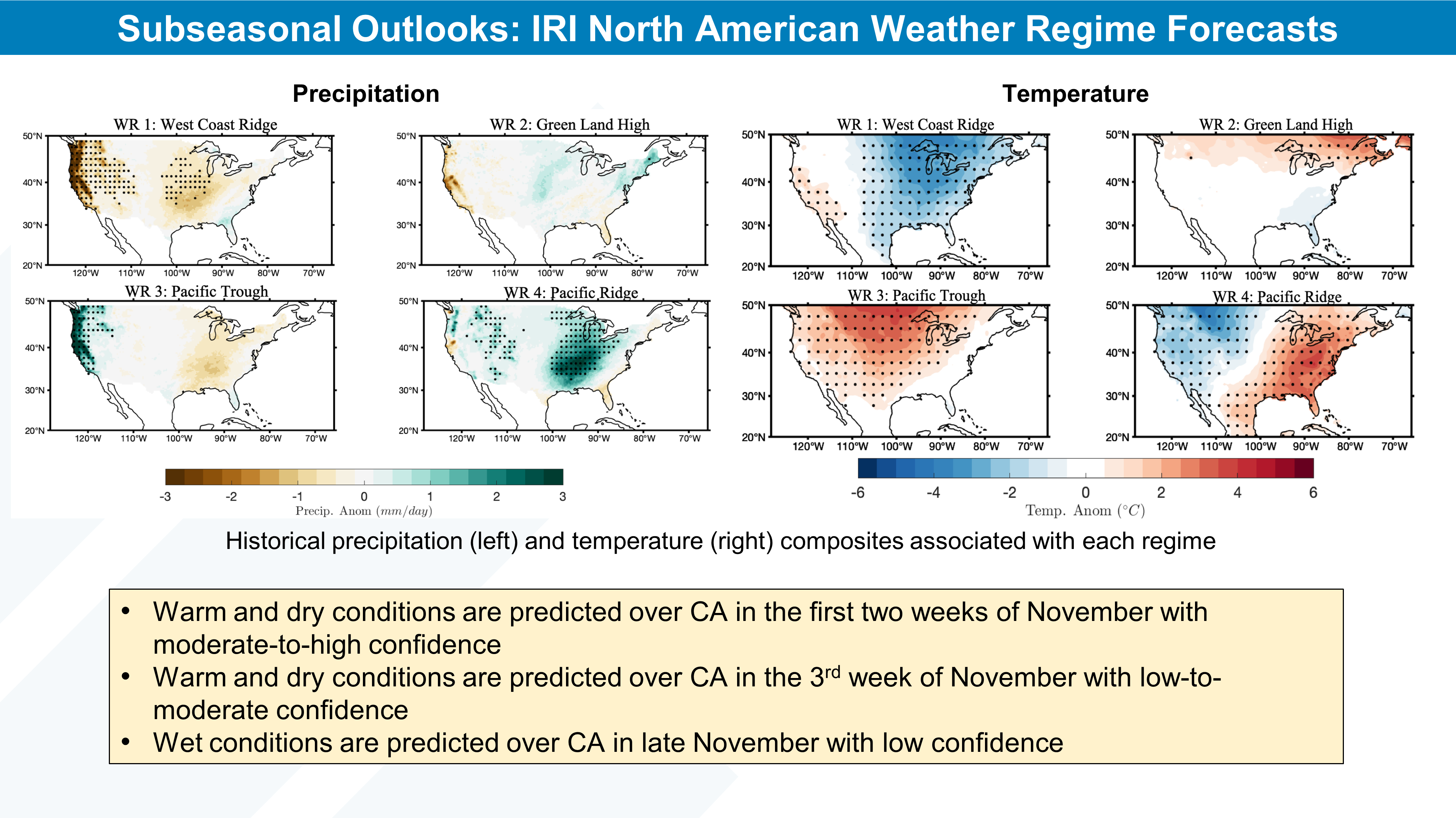
CW3E Subseasonal Outlook: 3 November 2023

CW3E Subseasonal Outlook: 3 November 2023

November 3, 2023

Click here for a pdf of this information.


Summary provided by C. Castellano, J. Wang, Z. Yang, M. DeFlorio, and J. Kalansky; 3 November 2023

To sign up for email alerts when CW3E post new AR updates click here.

*Outlook products are considered experimental

CW3E delivers guest lecture and field laboratory session for the Watershed Protection and Restoration class at Feather River College

CW3E delivers guest lecture and field laboratory session for the Watershed Protection and Restoration class at Feather River College

Nov 1, 2023

Center for Western Weather and Water Extremes (CW3E) hydrologists Garrett McGurk and Gabe Lewis recently visited Feather River College (FRC) in Quincy, California, to deliver a paired guest lecture and field laboratory session for the Watershed Protection and Restoration class. The class, taught by FRC Assistant Professor Dana Flett, is designed to provide students with essential concepts, techniques, and tools to comprehend the structure and function of watersheds and how to apply this knowledge to stream corridor restoration.

During their lecture, Garrett and Gabe shared their personal journeys to becoming hydrologists, the mission of CW3E, FIRO, AR Recon, CW3E research and operations partnerships, the importance of both high-quality meteorological and hydrological measurements, and the principles of streamflow monitoring. The students were highly engaged and actively participated by asking numerous questions during and after the presentation.

Before the visit, the students had already gathered manual discharge measurements and conducted a stream channel survey on a section of Spanish Creek situated on FRC-owned property near a CW3E hydrometeorological monitoring station installed in 2019 as part of Yuba-Feather FIRO. To supplement this data, Garrett and Gabe’s lab focused on streamgaging techniques, ultimately leading to the installation of a new streamgage on Spanish Creek. This streamgage comprises a stilling well that houses a pressure transducer for continuous level measurements and a staff gage to facilitate visual level observations.

During the lab, students took turns operating power tools and installing concrete anchors to secure the stilling well and staff gage to concrete blocks previously positioned to stabilize the channel bank. Students were also instructed on conducting discharge measurements using various flow monitoring equipment, the importance of minimizing error during high flow events, and field safety protocols. Fortunately, the water temperature allowed students to comfortably wade in the stream while engaging Garrett and Gabe in discussions related to hydrology and pertinent western water issues.

The recently installed streamgage on Spanish Creek is designed to capture continuous level measurements and will play a pivotal role in establishing a stage-discharge relationship, also known as a rating curve, in conjunction with manual discharge measurements. Developing a rating curve is a key element of FRC’s long-term objectives for stream channel restoration on Spanish Creek. The streamgage will serve to characterize baseline conditions prior to any restoration activities, providing valuable insights into the current state of the waterway. Spanish Creek is an important tributary of the Feather River, which is part of the Yuba-Feather FIRO project.

While the streamgage is not currently equipped with telemetry, FRC has plans to upgrade the station with telemetered equipment in the near future. This upgrade will enhance the accessibility and real-time monitoring capabilities of the streamgage, further advancing their ability to track and respond to changing conditions on Spanish Creek.

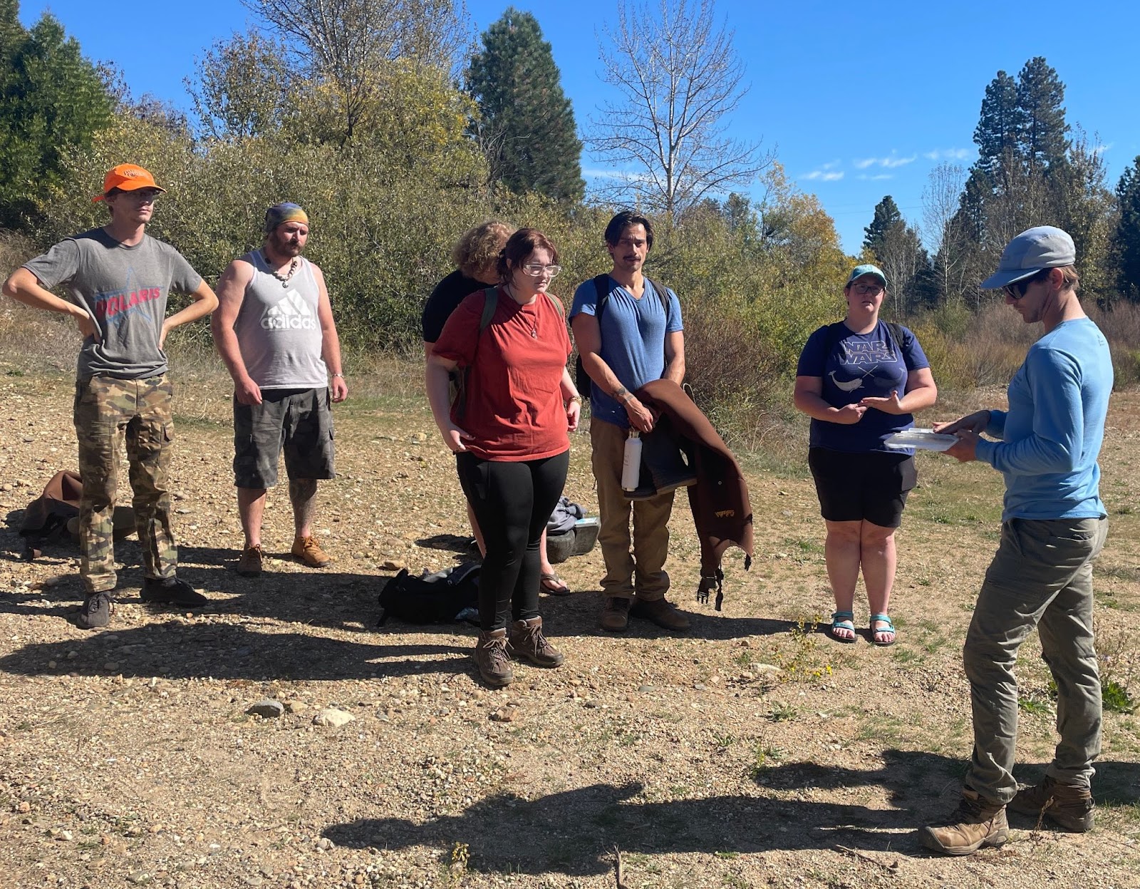
Students from Feather River College learn about the equipment used to monitor streamflow and the importance of hydrologic measurements from CW3E hydrologist Garrett Mcgurk.

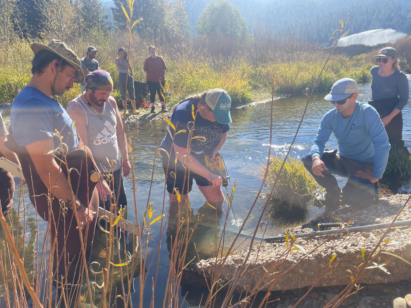
Students from Feather River College take turns helping to install a staff gage to measure stream level during a field laboratory session for the Watershed Protection and Restoration class.

CW3E Publication Notice: Impacts of Dropsonde Observations on Forecasts of Atmospheric Rivers and Associated Precipitation in the NCEP GFS and ECMWF IFS models

CW3E Publication Notice

Impacts of Dropsonde Observations on Forecasts of Atmospheric Rivers and Associated Precipitation in the NCEP GFS and ECMWF IFS models

October 31, 2023

A paper titled “Impacts of Dropsonde Observations on Forecasts of Atmospheric Rivers and Associated Precipitation in the NCEP GFS and ECMWF IFS models” by Laurel DeHaan (CW3E), Anna Wilson (CW3E), Brian Kawzenuk (CW3E), Minghua Zheng (CW3E), Luca Delle Monache (CW3E), Xingren Wu (NOAA/NCEP and Axiom Consultants), David A. Lavers (ECMWF), Bruce Ingleby (ECMWF), Vijay Tallapragada (NOAA/NCEP, AR Recon Co-PI), Florian Pappenberger (ECMWF), and F. Martin Ralph (CW3E Director and AR Recon PI) was recently accepted in Weather and Forecasting. This paper investigates the differences in skill between forecasts that assimilated dropsonde data from Atmospheric River Reconnaissance (AR Recon) and forecasts that did not assimilate the dropsonde data, and illustrates improvements in the forecasts that do include the additional dropsonde data. This work supports the Atmospheric Rivers (AR) Research and Applications Priority Areas in CW3E’s 2019-2024 Strategic Plan, and represents an important international, interagency collaboration, in the framework of a Research And Operations Partnership, to diagnose the impact of AR Recon data. Forecast comparison is made in terms of both precipitation and integrated vapor transport (IVT) at multiple thresholds (13, 25, and 50 mm for precipitation, and 250 and 500 kg m-1 s-1 for IVT) for two global numerical prediction models: the Integrated Forecast System (IFS) from the European Centre for Medium-Range Weather Forecasts (ECMWF) and the Global Forecast System (GFS) from the National Centers for Environmental Prediction (NCEP). The comparison was made for 22 different Intensive Observation Periods (IOPs) in 2019 and 2020 at lead times from one to five days.

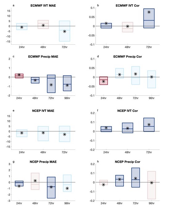
Differences between the control and denial forecasts were measured in terms of mean absolute error (MAE) and spatial correlation for both IVT and precipitation skill. In addition, the difference in precipitation was also measured using Fractions Skill Score (FSS) and a watershed intensity metric. Figure 1 shows an example of the comparison between the control and denial forecasts in terms of MAE and spatial correlation averaged over multiple thresholds. In this example, both models show generally modest improvement with the inclusion of dropsondes in IVT MAE and show larger improvements in IVT using the correlation metric. The NCEP model shows significant improvement at all three lead times for IVT correlation (Fig. 1f). For precipitation, the ECMWF model has significant improvements in MAE with the control forecasts at three lead times (Fig. 1c) and the NCEP model has significant improvements at two lead times (Fig. 1g). The correlation of precipitation has mixed results, with the only significant improvements with the control forecasts occurring at 48 and 72-hour lead times for the NCEP model (Figs. 1 d, h).

Combining this example with the other comparisons in the publication, this work illustrates that, more often than not, forecasts were improved when dropsonde data were assimilated. Both the ECMWF IFS and the NCEP GFS models show many improvements in forecast skill with the added information from the dropsondes. In particular, significant improvements in the control forecast IVT generally occur in both models, especially at a higher threshold. Significant improvements in the control forecast precipitation also generally occur in both models, but the two models are not consistent in the lead times and metrics that demonstrate the improvements.
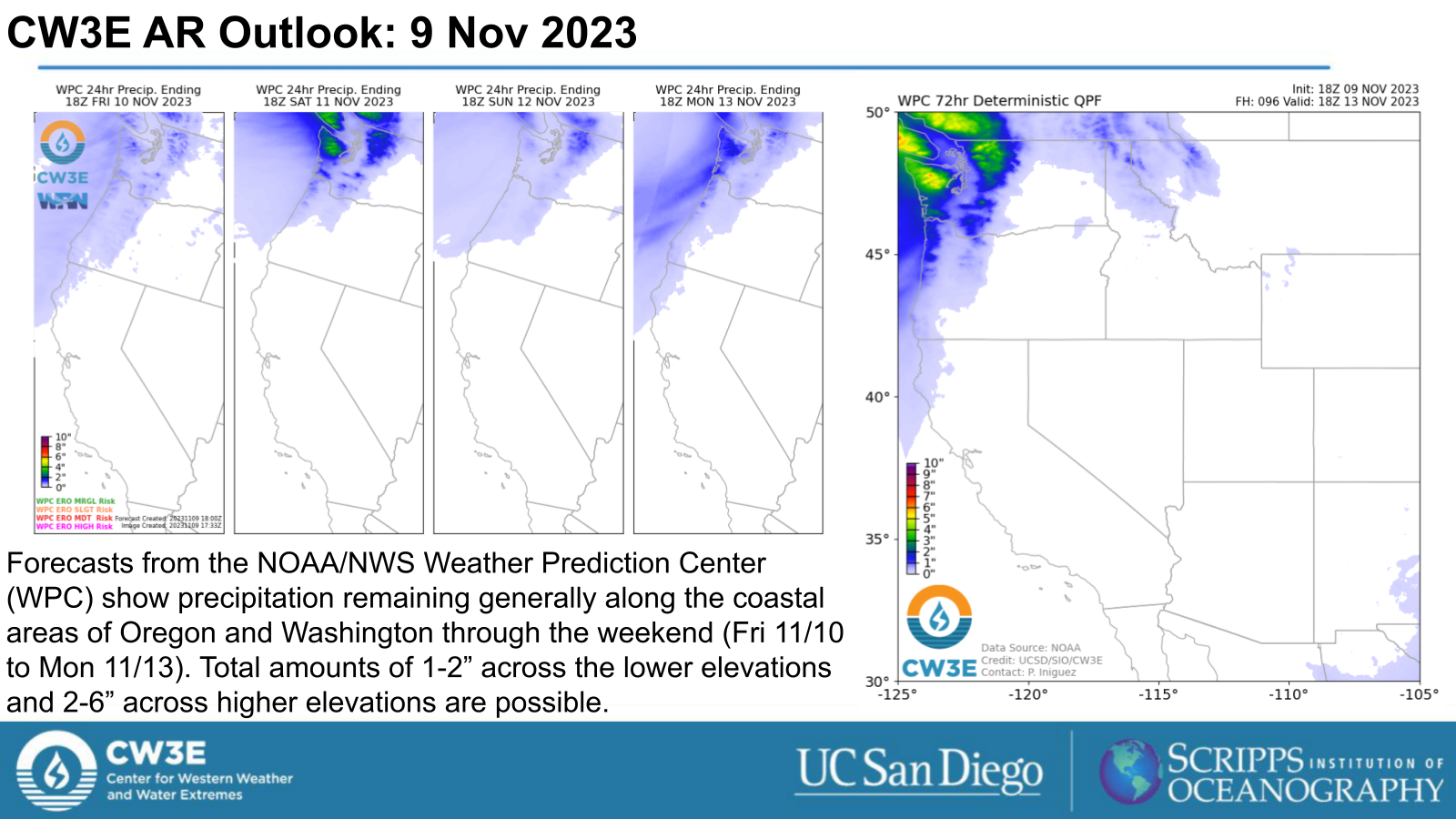
Figure 1: (Figure 6 from DeHaan et al 2023): Averages of differences (control – denial) in error or correlation across all thresholds. Boxes are the interquartile range; the middle line is the median and the asterisk shows the mean. Blue colors indicate the control has less MAE or higher correlation in the mean; red colors indicate the denial has less MAE or higher correlation in the mean. Darker shades indicate significant differences in the mean based on a 90% confidence interval computed with bootstrapping.

DeHaan, L. L., and Coauthors, 2023: Impacts of Dropsonde Observations on Forecasts of Atmospheric Rivers and Associated Precipitation in the NCEP GFS and ECMWF IFS models. Wea. Forecasting, https://doi.org/10.1175/WAF-D-23-0025.1, in press.

Corresponding author: Laurel Dehaan

CW3E AR Update: 30 October 2023 Outlook

CW3E AR Update: 30 October 2023 Outlook

October 30, 2023

Click here for a pdf of this information.

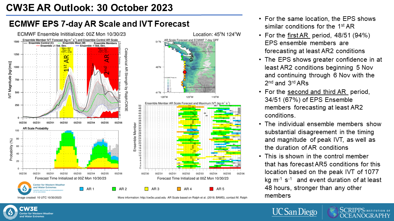
Multiple Atmospheric Rivers Forecast to Impact Pacific Northwest and Northern California

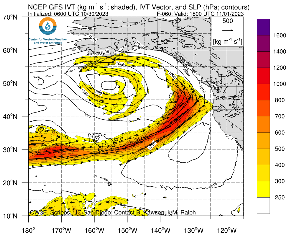
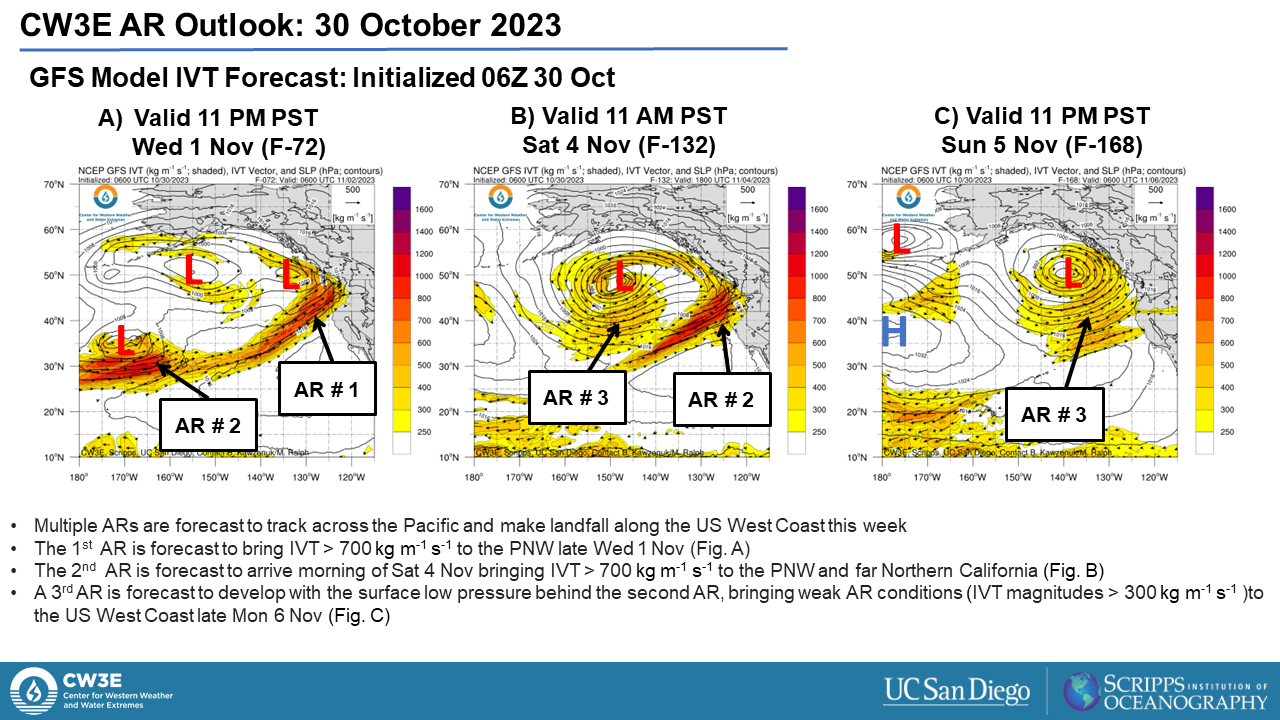
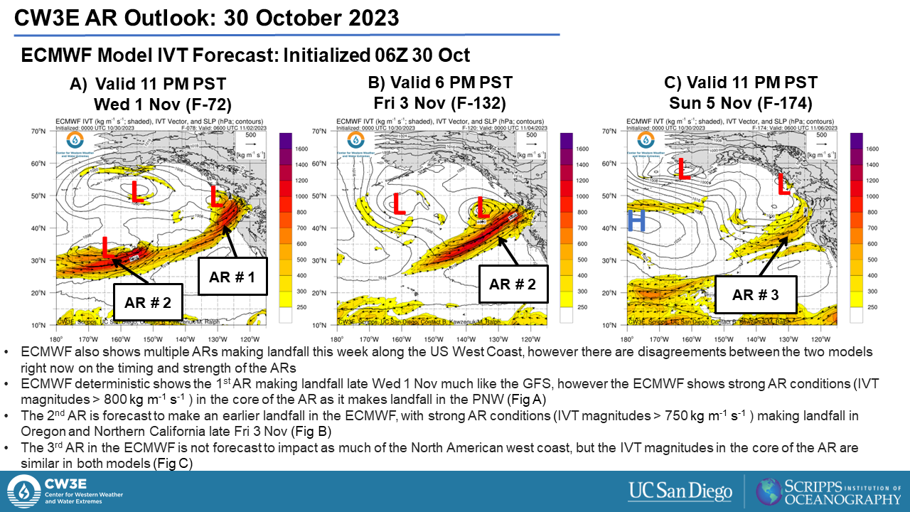
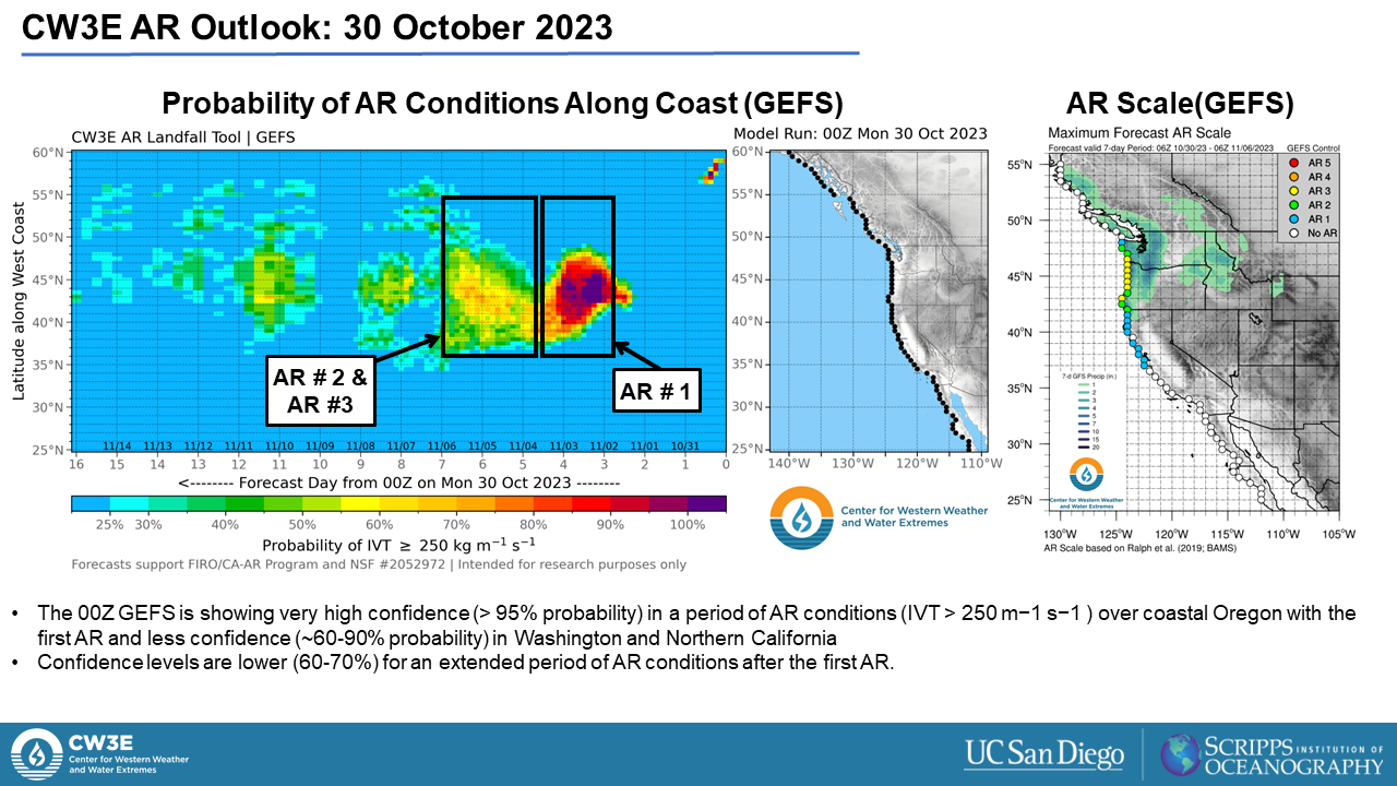
  • Multiple atmospheric rivers (AR) are forecast to make landfall in the Pacific Northwest over the next 7 days, the first late Wed 1 Nov
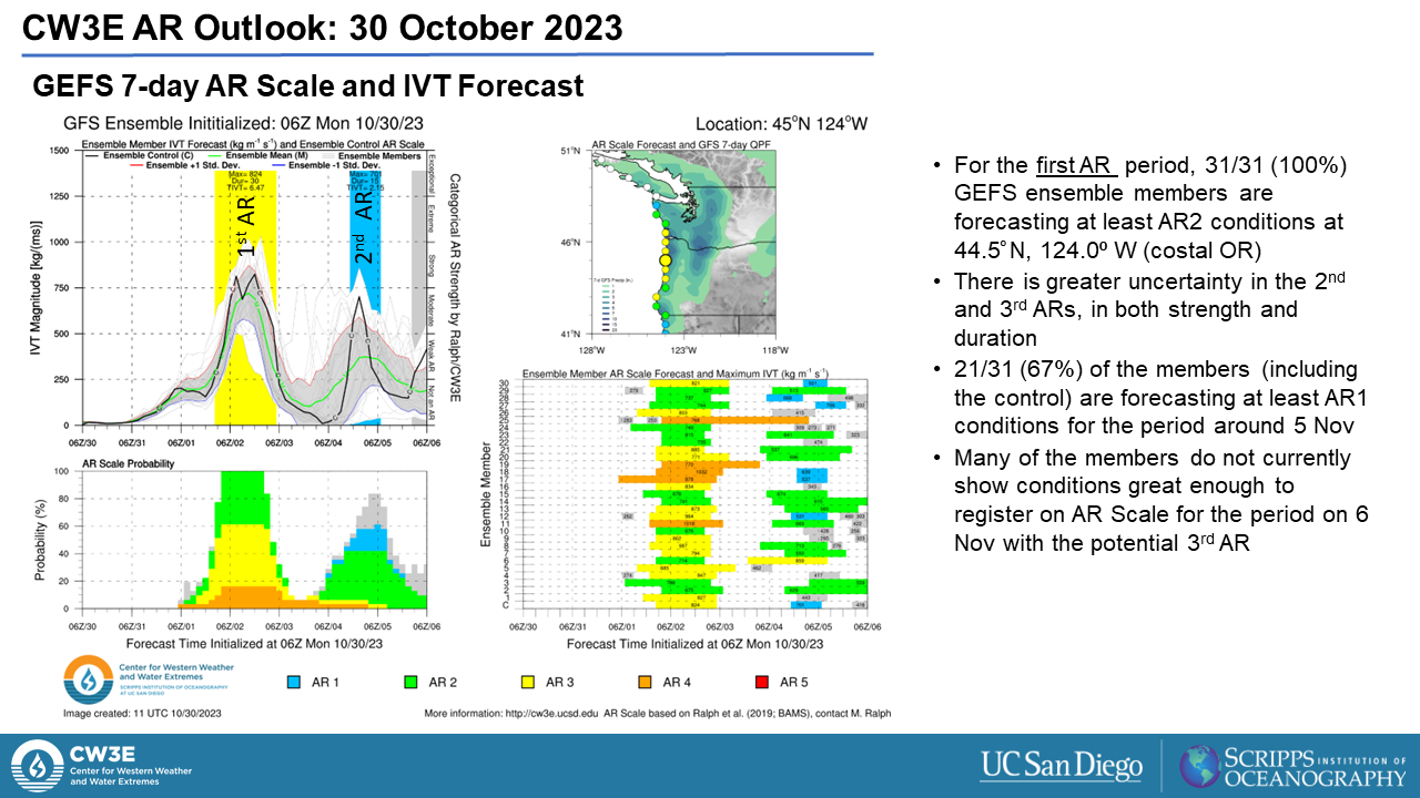
  • AR2 conditions (based on Ralph et al. scale) are forecast during the first AR, with a ~24 hour period of IVT >800 kg m-1 s-1 forecast for Washington to Northern California in both the GFS and ECMWF
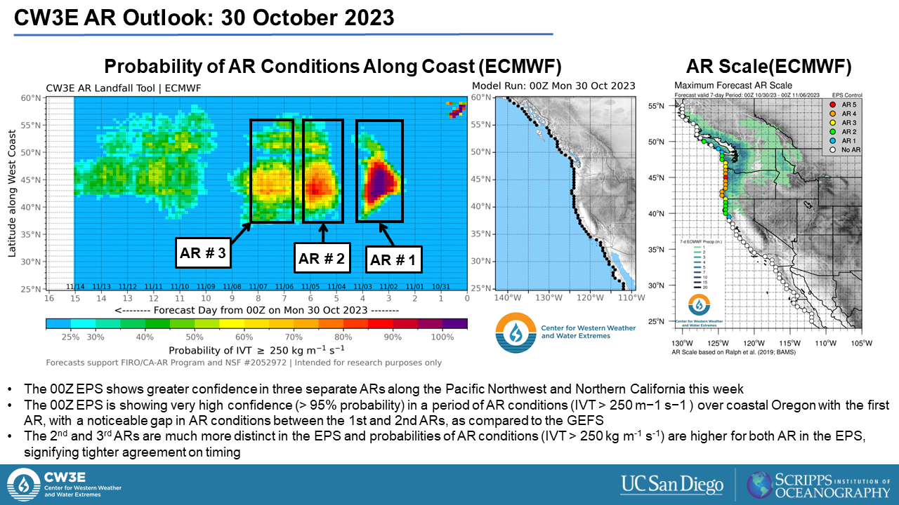
  • There is disagreement in the timing, strength and duration of the ARs that follow between the models
  • The GFS is forecasting AR1 conditions during the second AR along the coast of Central Oregon into Northern California early Sat 4 Nov, with a ~15 hour period of IVT >700 kg m-1 s-1 forecast in this region
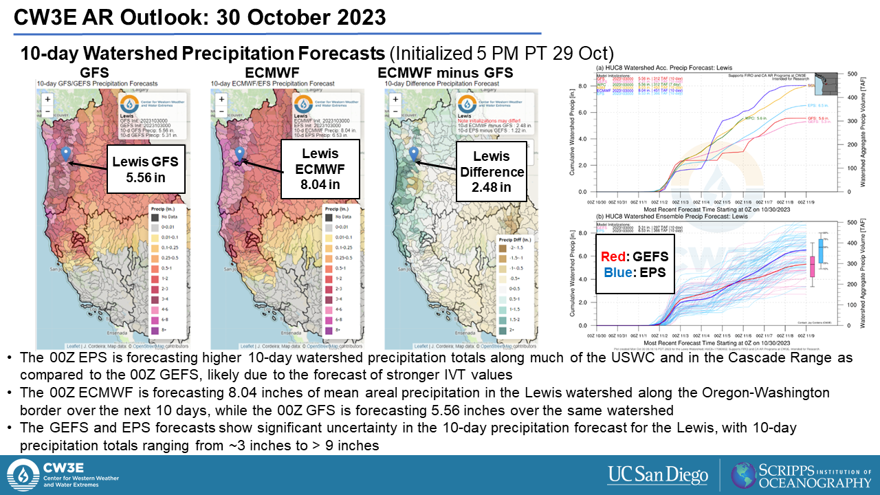
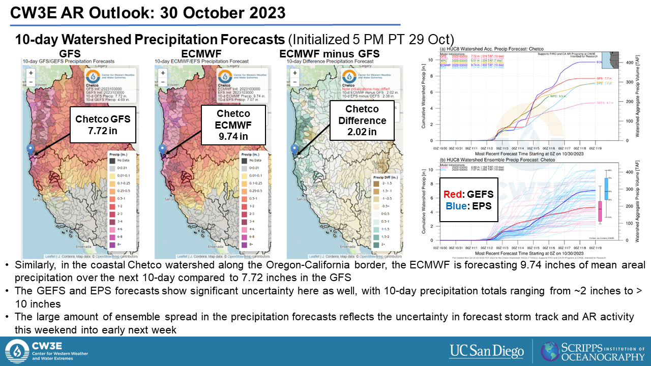
  • The second AR is forecast to make landfall late Fri 3 Nov in the ECMWF, where EPS ensemble members are forecasting the second AR to be stronger and for AR conditions to persist longer than the GEFS, resulting in significant differences in precipitation forecasts
  • GEFS ensemble members show uncertainty of the forecast conditions for the third AR to register on the Ralph et al. scale, while the EPS shows many members forecasting AR conditions persisting from the second AR through to the third with the arrival of the next moisture corridor
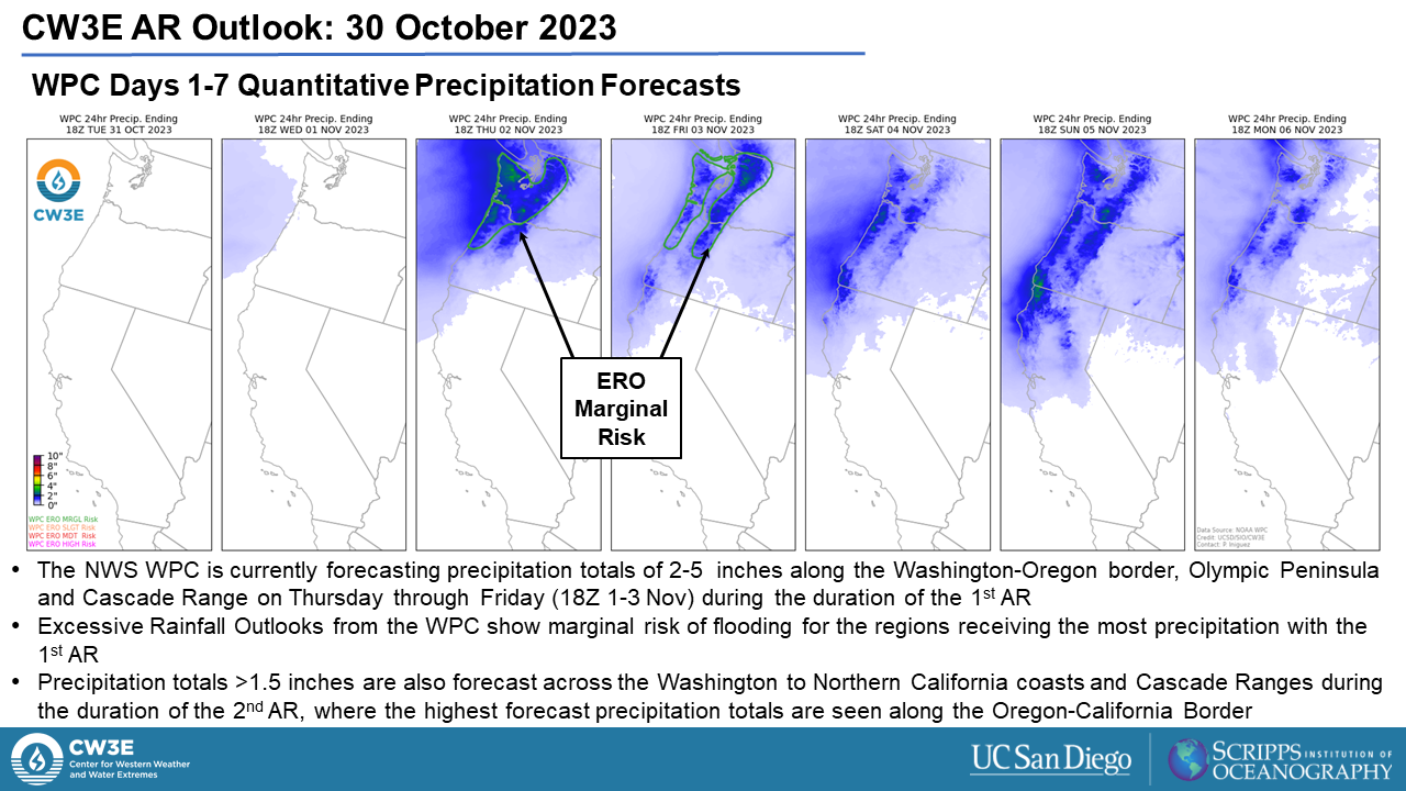
  • The NWS Weather Prediction Center (WPC) is forecasting precipitation totals >1.5 inches during the first AR for the Olympic Peninsula, Cascade Range and Washington and Oregon Coasts
  • Precipitation associated with these ARs are forecast to be primarily beneficial to the Pacific Northwest where widespread drought conditions are present, with no river levels forecast to rise above action stage within the boundaries of the NWS Northwest River Forecast center
  • Most of the precipitation is expected to fall as rain, with freezing levels forecast to stay above 6000 feet throughout these events

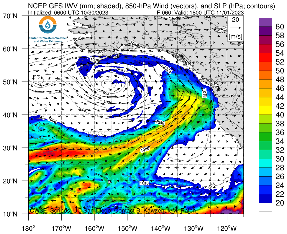
Click images to see loops of GFS IVT and IWV forecasts

Valid 1800 UTC 01 November – 0600 UTC 06 November 2023


Summary provided by M. Steen, P. Iniguez, S. Bartlett, C. Castellano, S. Roj and J. Kalansky; 30 October 2023

To sign up for email alerts when CW3E post new AR updates click here.

*Outlook products are considered experimental

CW3E Publication Notice: From California’s Extreme Drought to Major Flooding: Evaluating and Synthesizing Experimental Seasonal and Subseasonal Forecasts of Landfalling Atmospheric Rivers and Extreme Precipitation during Winter 2022 – 2023

CW3E Publication Notice

From California’s Extreme Drought to Major Flooding: Evaluating and Synthesizing Experimental Seasonal and Subseasonal Forecasts of Landfalling Atmospheric Rivers and Extreme Precipitation during Winter 2022 – 2023

October 24, 2023

CW3E researcher Mike DeFlorio, along with co-authors from CW3E, the National Institute of Water and Atmospheric Research (NIWA), the University of Arizona, the University of Graz, the International Research Institute for Climate and Society (IRI), the NASA Jet Propulsion Laboratory, the NOAA Climate Prediction Center, and the California Department of Water Resources (CA DWR), recently published a paper entitled “From California’s Extreme Drought to Major Flooding: Evaluating and Synthesizing Experimental Seasonal and Subseasonal Forecasts of Landfalling Atmospheric Rivers and Extreme Precipitation during Winter 2022 – 2023” in the Bulletin of the American Meteorological Society (BAMS). This research contributes to both the S2S (Subseasonal-to-Seasonal) Prediction of Extreme Weather and Atmospheric Rivers (AR) Research and Applications Priority Areas in CW3E’s 2019-2024 Strategic Plan, and represents a substantial cross-institutional collaborative effort to diagnose observations and evaluate S2S forecasts of ARs, circulation regimes, and extreme precipitation during last year’s historic winter over California and the broader western U.S. region.

The key objectives of this paper are to:

  1. Diagnose observations before and after the 3-week active AR period over California during December 2022 – January 2023, and provide context for how AR landfalls during this period substantially alleviated multi-year drought over California
  2. Evaluate experimental seasonal and subseasonal forecasts of ARs, circulation regimes, and precipitation over the western U.S. and North Pacific Ocean during Winter 2022 – 2023
  3. Introduce experimental western U.S. seasonal and subseasonal forecast synthesis products that summarize and aggregate key information across institutions and methods to provide situational awareness guidance to end users

Figure 1 below (Figure 5 from the BAMS article) illustrates the substantial impact of nine landfalling ARs during December 2022 – January 2023 in alleviating multi-year drought conditions across California and Nevada. During the October 2019 – November 2022 period when drought was still widespread, the equivalent of 1-2 normal water years’ worth of precipitation did not fall across much of Northern and Central California, and Southern California was also in a precipitation deficit. However, by the end
of January 2023, many parts of Central California (including the Sierra Mountain Range), as well as coastal Southern California, were no longer in deficit mode, as indicated by the white regions in panel c). Conditions improved dramatically across Northern California, though many areas remain in deficit compared to normal conditions for the 3.5 year period shown in panel c).

Figure 1: Figure 5 from DeFlorio et al. 2023 (BAMS). Deviations from 1981-2010 normal of precipitation accumulated during (a) October 2019 (beginning of recent drought) through November 2022, (b) total precipitation between December 2022 and January 2023, and (c) between October 2019 and January 2023, with missing or extra overall precipitation expressed in terms of normal water-years. White areas in panel (c) are regions where the net 3.5 years of precipitation anomalies were no longer in deficit mode by the end of January 2023. Precipitation amounts illustrated here are the PRISM 4-km resolution monthly datasets.

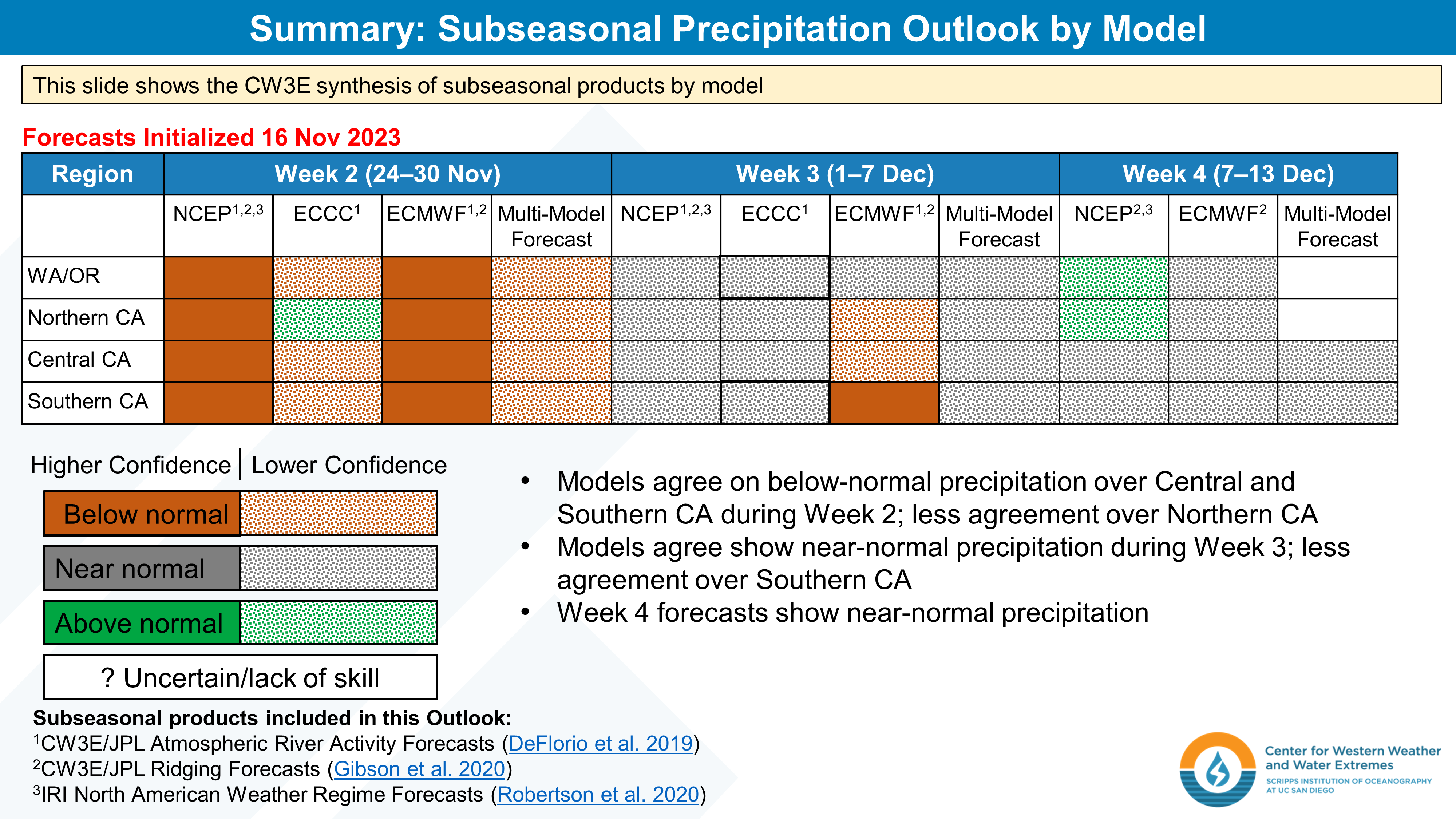
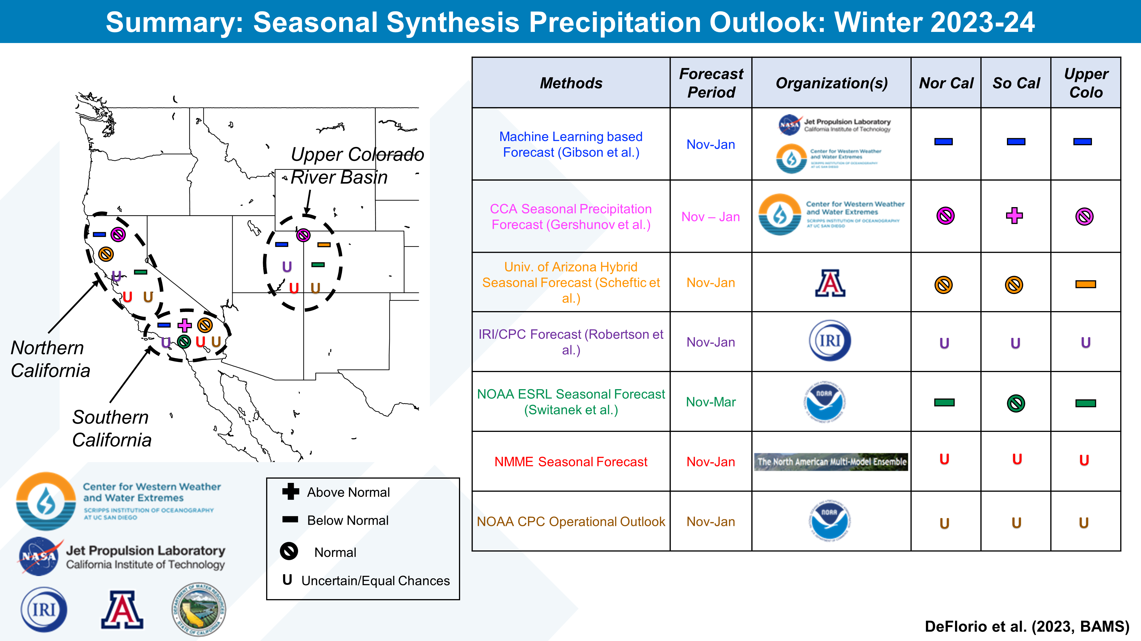
During the past several winters, CW3E has been developing experimental seasonal and subseasonal forecast synthesis products in close coordination with stakeholders at CA DWR. An example of the CW3E experimental subseasonal forecast synthesis product applied to the period of interest in this study is shown below in Figure 2 (Figure 12 from the BAMS article). These experimental synthesis products will be included in CW3E’s weekly S2S outlooks during the Winter 2023-2024 season.

Figure 2: Figure 12 from DeFlorio et al. 2023 (BAMS). CW3E experimental subseasonal (weeks 2-4 lead time) synthesis forecast product for December 22, 2022 00Z subseasonal dynamical ensemble forecasts. The regions include Washington/Oregon (WA/OR), Northern California, Central California, and Southern California (each row). Forecast results from three models (NCEP, ECCC, ECMWF) are shown respectively in each column. The superscripts indicate the different types of subseasonal products being considered in the synthesized forecasts. High confidence is determined when there is a ≥75% probability of a pattern conducive to above normal, below normal, or near normal conditions, and if the majority (>50%) of the forecast products agree on the sign of the anomaly. Low confidence is determined when there is a <75% probability of a pattern conducive to above normal, below normal, and near normal conditions, and >50% of the forecast products agree on the sign of the anomaly. If the individual forecast products disagree on the sign of the anomaly, the synthesized forecast is classified as uncertain.

DeFlorio, M.J., A. Sengupta, C.M. Castellano, J. Wang, Z. Zhang, A. Gershunov, K. Guirguis, R. Luna Niño, R.E. Clemesha, M. Pan, M. Xiao, B. Kawzenuk, P.B. Gibson, W. Scheftic, P.D. Broxton, M.B. Switanek, J. Yuan, M.D. Dettinger, C.W. Hecht, D.R. Cayan, B.D. Cornuelle, A.J. Miller, J. Kalansky, L. Delle Monache, F.M. Ralph, D.E. Waliser, A.W. Robertson, X. Zeng, D.G. DeWitt, J. Jones, and M.L. Anderson (2023), From California’s extreme drought to major flooding: Evaluating and synthesizing experimental seasonal and subseasonal forecasts of landfalling atmospheric rivers and extreme precipitation during Winter 2022 – 2023. Bulletin of the American Meteorological Society, in press, doi:10.1175/BAMS-D-22-0208.1.

CW3E AR Update: 13 October 2023 Outlook

CW3E AR Update: 13 October 2023 Outlook

October 13, 2023

Click here for a pdf of this information.

Multiple Atmospheric Rivers Forecast to Impact Pacific Northwest Through the Weekend

  • A series of atmospheric rivers (ARs) are forecast to make landfall over the Pacific Northwest during the next few days
  • The first and second ARs are forecast to bring weak AR conditions (IVT < 500 kg m−1 s−1) to coastal Washington, Oregon, and Northern California today and Saturday
  • The third and strongest AR is forecast to make landfall Sunday into Monday
  • An AR4/AR5 is possible in coastal OR due to IVT magnitudes potentially exceeding 1000 kg m−1 s−1 and AR conditions potentially lasting more than 48 consecutive hours between the second and third ARs
  • There is still considerable forecast uncertainty in the intensity of the third landfalling AR
  • The ECMWF Ensemble Prediction System (EPS) continues to forecast higher IVT magnitudes in coastal OR and WA compared to the NCEP Global Ensemble Forecast System (GEFS)
  • The NWS Weather Prediction Center (WPC) is forecasting at 2–5 inches of precipitation in the Olympic Mountains and North Cascades during the next 5 days
  • Models are still showing some disagreement in forecast precipitation, with the ECMWF/EPS models predicting higher precipitation amounts in the Olympic Peninsula compared to the GFS/GEFS models
  • Despite the high likelihood of strong AR conditions (IVT > 750 kg m−1 s−1) during the third AR, the south-southwesterly orientation of moisture transport will be unfavorable for orographic enhancement of precipitation in most areas, and significant hydrologic impacts are not anticipated

Click images to see loops of GFS IVT and IWV forecasts

Valid 1200 UTC 13 October – 1200 UTC 20 October 2023


Summary provided by C. Castellano, S. Bartlett, P. Iniguez, J. Kalansky, and S. Roj; 13 October 2023

To sign up for email alerts when CW3E post new AR updates click here.

*Outlook products are considered experimental

CW3E Welcomes Jacob Morgan

CW3E Welcomes Jacob Morgan

October 12, 2023

Jacob joined CW3E in October 2023 as a field research engineer. Prior to joining the Center, Jacob earned his BSc and MSc in Earth Sciences from the University of Oxford (2016) and his PhD in Climate Science from Scripps Institution of Oceanography (2023)

Jacob’s doctoral research focused on reconstructing past climate using the composition of air bubbles preserved in ancient Antarctic ice cores. By measuring the composition of oxygen in the bubbles trapped in Antarctic ice cores, Jacob reconstructed periodic northward and southward shifts in the position of the ITCZ during the last glacial period, between twenty thousand and seventy thousand years ago. The shifts occurred in sync with Dansgaard-Oeschger events–abrupt climate warmings in the North Atlantic–and were associated with a strengthening and weakening of the Northern Hemisphere tropical monsoon systems and fluctuations in tropical biosphere productivity.
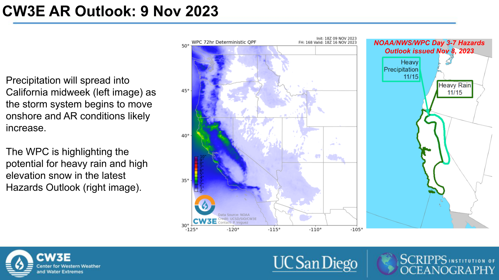
At CW3E, Jacob will be a member of the field team and is excited to get involved with their various projects. He has plenty of experience navigating the complex logistics involved in executing successful fieldwork projects in remote locations and extreme weather–his list of previous field sites includes Antarctica, Greenland, the Pyrenees, and Bermuda. He is eager to now put these skills to use in the Western US.