CW3E Field Trip to Experience the North American Monsoon in Southern Arizona

CW3E Field Trip to Experience the North American Monsoon in Southern Arizona

August 14, 2017

Several members of CW3E spent a recent weekend observing the North American monsoon in the Tucson, Arizona area, including Nogales and Sonoita. It provided an opportunity to experience an iconic type of “extreme event” that occurs in the Western U.S.

Activities included early-morning hiking in Ventana Canyon (Fig. 1), touring southern Arizona from Tucson to Nogales, Patagonia and Sonoita, learning about Sonoran Desert and nearby grassland landscapes and climate (Fig. 2), observing long-lived monsoon convection and its impacts, and discussing active topics of research related to the North American monsoon, including a recent paper on the role of the Chiricahua Gap (Ralph and Galerneau 2017 – http://journals.ametsoc.org/doi/abs/10.1175/JHM-D-17-0031.1).

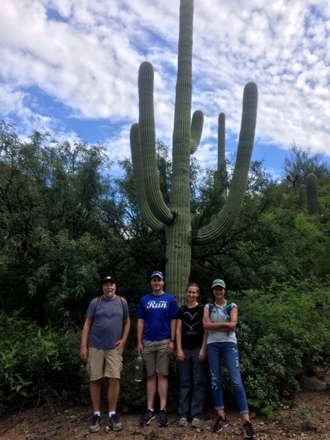
Fig.1. The CW3E group with a saguaro during the Ventana Canyon hike. From left Marty Ralph, Brian Henn, Anna Wilson, and Maryam Asgari-Lamjiri.

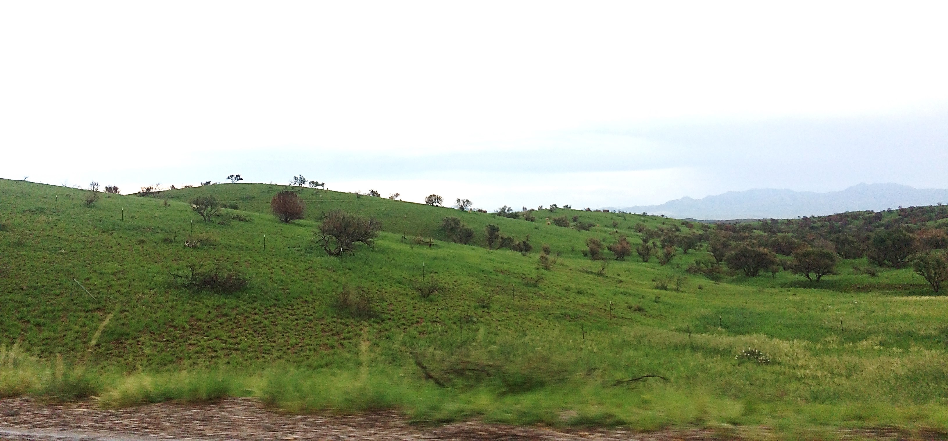
Fig.2. Example of landscape 30 miles southeast of Tucson, near Sonoita, AZ on 29July 2017 at about 5000 ft MSL.

A highlight was observing flood water in normally dry washes, such as Tanque Verde Wash in northeast Tucson (Fig. 3).

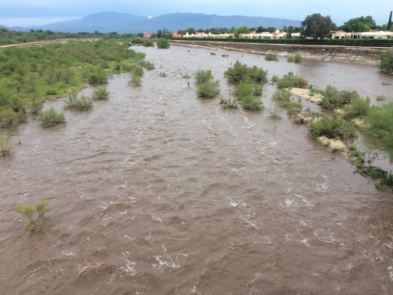
Fig.3. The Tanque Verde River looking east from the bridge on Kolb Road after monsoon storms in the Tucson area. The Rincon Mountains, including their high point at 8664 ft MSL, are in the background. Photograph taken at 6:45 pm local time on 29 July 2017.

Precipitation totals in Tucson were significantly above normal. Fig. 4 shows the July 2017 climate summary from NWS. In fact, the CW3E team experienced the heavy downpour near the Tucson airport on Saturday, 29 July 2017 that broke the all-time record for July monthly precipitation (now 6.8 inches; previously 6.24 inches in July 1921).

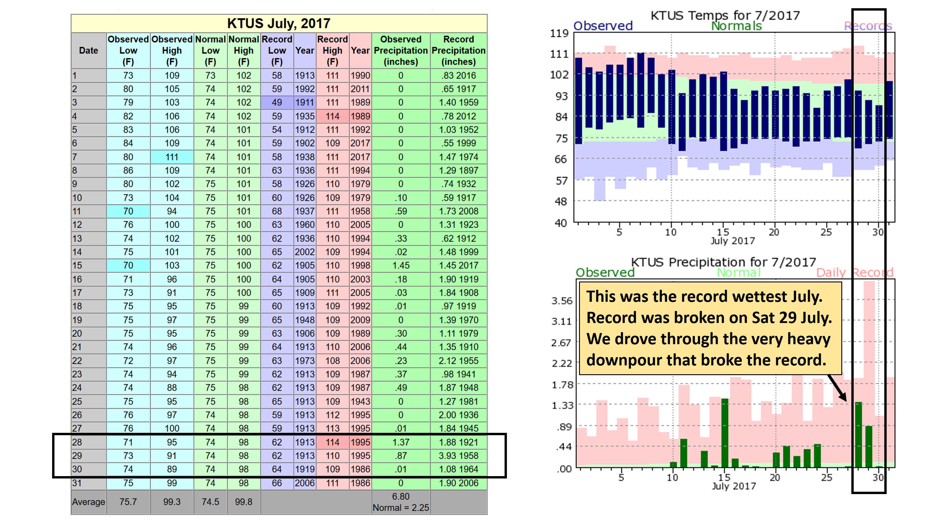
Fig.4. National Weather Service July 2017 climate summary with dates of the CW3E field trip highlighted.

CW3E’s goal is to revolutionize the physical understanding, observations, weather predictions and climate projections of extreme events in Western North America (/overview/), including the North American summer monsoon.

Points of contact: Anna Wilson, Marty Ralph.

Sonoma County Water Agency Board of Directors Chairwoman, Zane, testifies on FIRO before Senate Committee

Sonoma County Water Agency Board of Directors Chairwoman, Zane, testifies on FIRO before Senate Committee

August 2, 2017

CW3E works closely with Sonoma County Water Agency (SCWA) on the application of atmospheric river science to inform water management practices in the Russian River. SCWA and CW3E are leaders on the Forecast Informed Reservoir Operations (FIRO) project. FIRO is a proposed management strategy that uses data from watershed monitoring and modern weather and water forecasting to help water managers selectively retain or release water from reservoirs in a manner that reflects current and forecasted conditions. FIRO is being developed and tested as a collaborative effort focused on Lake Mendocino that engages experts in civil engineering, hydrology, meteorology, biology, economics and climate from several federal, state and local agencies, universities and others.

Shirlee Zane, SCWA Board of Directors Chairwoman, today testified before the Senate Committee on Energy and Natural Resources’ Subcommittee on Water and Power to discuss the many innovative water supply and drought resilience initiatives the Water Agency is currently implementing, including FIRO. The purpose of the hearing was to examine increasing water security and drought preparedness through infrastructure, management and innovation.

“I was honored to testify and share with the committee the innovative water supply management tools the Sonoma County Water Agency is developing and implementing,” said Sonoma County Water Agency Chairwoman Shirlee Zane. “Securing our water future means thinking outside of the box and not being afraid to lead by example. That is exactly what the Water Agency continues to do as we develop first-class initiatives with our partners. Our investment in water innovation can be replicated across the nation. I am excited to share our experiences to help build innovation in the water industry.” Zane highlighted FIRO, amongst the many innovative water management programs the Water Agency is currently implementing.

For more information on FIRO: Click here

For video of the briefing click here.

American Geophysical Union Publishes Collection of Atmospheric River Publications in Geophysical Research Letters

American Geophysical Union Publishes Collection of Atmospheric River Publications in Geophysical Research Letters

July 27, 2017

The American Geophysical Union recently published a special hand selected collection of papers on atmospheric rivers that have been published in Geophysical Research Letters.​​

Atmospheric rivers are a relatively new phenomena in atmospheric science that have become a popular subject of meteorological, hydrological, and climatological research due to their influence on global moisture transport, extreme precipitation, flooding, drought mitigation, and water supply. The collection in GRL highlights the research that has been published over the past three decades beginning with Newell et al’s seminal paper, which introduced the term “tropospheric river.”

CW3E research is highlighted in the report with 5 of the papers in the collection being lead by CW3E researchers and an additional 8 papers with CW3E researchers as co-authors which discuss topics ranging from extreme precipitation to the influence of climate change on atmospheric river characteristics. The collection of papers can be found here

CW3E Publication Notice: Hourly Storm Characteristics along the U.S. West Coast: Role of Atmospheric Rivers in Extreme Precipitation

CW3E Publication Notice

Hourly Storm Characteristics along the U.S. West Coast: Role of Atmospheric Rivers in Extreme Precipitation

July 10, 2017

Fifty-five years of gridded hourly precipitation observations (CPC Hourly U.S. Precipitation) are used in this study to identify storm characteristics which most strongly modulate extreme storms along the U.S. West Coast. By investigating storms at fine (hourly) time scales, we showed that U.S. West Coast storm total precipitation is more strongly modulated by storm durations than by storm intensities, whereas in the Southeast U.S., storm intensities more strongly dictate the storm total precipitation (Figure 1, presented as Figure 2 in Lamjiri et al. [2017]). This study also showed that the most extreme precipitation events along the U.S. West Coast are associated with the most persistent atmospheric rivers, rather than the high intensity ARs. Therefore, it is of high importance to improve forecast skill of the duration of storms over the U.S. West Coast, which provides valuable information that could be used to mitigate flood risks and enhance water reservoir management. More details are provided in the full manuscript, which was published in the AGU journal Geophysical Research Letters: Lamjiri, M. A., M. D. Dettinger, F. M. Ralph, and B. Guan, 2017: Hourly storm characteristics along the U.S. West Coast: Role of atmospheric rivers in extreme precipitation, Geophys. Res. Lett., 44, doi:10.1002/2017GL074193. click here for personal use pdf file

Figure 1 Correlation coefficient of storm-precipitation totals with storm durations (a), maximum intensities (b), and average intensities(c) based on hourly precipitation observations from 1948-2002.


Abstract

Gridded hourly precipitation observations over the conterminous US, from 1948 to 2002, are analyzed to determine climatological characteristics of storm precipitation totals. Despite generally lower hourly intensities, precipitation totals along the U.S. West Coast (USWC) are comparable to those in Southeast U.S. (SEUS). Storm durations, more so than hourly intensities, strongly modulate precipitation-total variability over the USWC, where the correlation coefficients between storm durations and storm totals range from 0.7 to 0.9. Atmospheric rivers (ARs) contribute 30-50% of annual precipitation on the USWC, and make such large contributions to extreme storms that 60-100% of the most extreme storms, i.e. storms with precipitation-total return intervals longer than two years, are associated with ARs. These extreme storm totals are more strongly tied to storm durations than to storm hourly or average intensities, emphasizing the importance of AR persistence to extreme storms on the USWC.

CW3E Begins Installation of Instrumentation in the Russian River Watershed

CW3E Begins Installation of Instrumentation in the Russian River Watershed

July 7, 2017

CW3E began its summer fieldwork campaign in the Russian River watershed last week with the installation of surface meteorology, soil moisture and streamflow instruments. Pictured are CW3E members and collaborators from the U.S. Army Corps of Engineers and Sonoma County Water Agency after installing soil moisture sensors on the Corps’ property at Lake Mendocino. The observations from the fieldwork campaign will provide information on precipitation, soil moisture and streamflow during cool-season atmospheric rivers (ARs) that produce the majority of the inflows to Lake Mendocino. The reservoir is a focus of the Forecast Informed Reservoir Operations project, which assesses the potential to enhance water resources and flood control operations with hydrometeorological forecast data. The surface meteorology and hydrology data from the field campaign will complement additional observations of the atmosphere made by CW3E, NOAA and other project collaborators.​​

CW3E members and collaborators stand near the finished instrumentation tower with Lake Mendocino in the background. From left to right: Chad Hecht (CW3E), Will Chapman (CW3E), Kyle Evans (Sonoma County Water Agency), Steve Turnbull (US Army Corps of Engineers), Anna Wilson (CW3E), Douglas Alden (CW3E).

CW3E Participates in Western States Water Council Visit to UC Davis’ Bodega Marine Lab

CW3E Participates in Western States Water Council Visit to UC Davis’ Bodega Marine Lab

July 1, 2017

CW3E members were on hand recently at UC Davis’ Bodega Marine Lab to introduce some of the key instrumentation located there to sample atmospheric rivers (ARs). The audience included members of the Western States Water Council (WSWC), California Department of Water Resources (DWR), and Sonoma County Water Agency (SCWA). The audience toured state-of-the-art onsite instrumentation and learned about its significance for forecasting and research into ARs. This instrumentation included the Atmospheric River Observatory, which was installed as part of the California Enhanced Flood Response and Emergency Preparedness network (partners include DWR, NOAA, and Scripps), and has been making observations consistently at this location since 2004, as well as instrumentation installed during the past winter by CW3E to observe surface microphysics and vertical precipitation structure. CW3E collaborator Bruce Cornuelle gave a talk on the importance of ocean observations for numerical weather prediction at all scales, including subseasonal to seasonal. The conclusion of the visit featured a demonstration radiosonde release at Bodega Bay. 275 sondes in total were released by CW3E during historically wet Jan-Mar 2017 at the Bodega Marine Lab as well as an inland location to assess water vapor transport by ARs as they move inland and interact with the terrain.

Fig.1. Bruce Cornuelle gives a talk on the importance of ocean observations for numerical weather prediction and subseasonal to seasonal forecasting. Image also includes a model of an ARGO float (http://argo.ucsd.edu/). Photo courtesy CA DWR.

Fig.2. CW3E (a), WSWC (b), and SCWA (c) members before the demonstration radiosonde launch.
Photos courtesy CA DWR.

Points of contact: Anna Wilson, Marty Ralph.

CW3E Graduate Students Complete Advanced Study Program in Colorado

CW3E Graduate Students Complete Advanced Study Program in Colorado

June 29, 2017

CW3E graduate students Meredith Fish and Tashiana Osborne were selected to participate in the competitive Advanced Study Program on the Interaction of Precipitation with Orography. The program is a two-week colloquium held at the National Center for Atmospheric Research (NCAR) Mesa Lab in Boulder, Colorado.

Osborne and Fish, along with 24 other students from around the globe, heard dynamic talks from professors, researchers, academics, and professionals from federal agencies such as NCAR and NOAA and universities such as the University of Washington, the University of Colorado Boulder and the University of Miami, as well as many others. The lectures focused on precipitation in the world’s mountainous regions. One of the speakers was CW3E post-doc Nick Siler, who spoke about his research on orographic rain shadows. Talks addressed a variety of topics including the dynamical flow and physical science, challenges in weather and climate modeling around these regions and interactions of between the atmosphere, land and ocean, as well as professional development.

Students visit the Mountain Research Station where researchers focus on advancing the study of mountain ecosystems; Elevation: ~9500 feet. Photo credit: Richard Neale, Project Scientist at NCAR

Students also grew through hands-on practical sessions analyzing observed precipitation datasets, such as PRISM and TRMM, and running the NCAR Weather Research and Forecasting Model (WRF) and Community Earth System Model (CESM). CW3E has designed a version of WRF that is tailored for West Coast atmospheric rivers, with an aim to enhance understanding of precipitation processes. Following this colloquium, students are able to bring the practical expertise gained at NCAR back to Scripps and CW3E to further enhance scientific understanding of precipitation over orography. During the last week of the colloquium, students applied new skills and knowledge to design and complete their own research project incorporating WRF and CESM modeling techniques to present on the last day.

Fun group photo of the students participating in the colloquium; featuring NCAR Project Scientist, Richard Neale. Photo Credit: Valerie Sloan, Director of GEO REU Network and Internship Specialist at the University Corporation for Atmospheric Research (UCAR)

CW3E Welcomes Dr. Aneesh Subramanian

CW3E welcomes Dr. Aneesh Subramanian

June 29, 2017

Dr. Aneesh Subramanian started at CW3E in April 2017 as a Project Scientist. Aneesh graduated from the Climate Research Division at Scripps Institution of Oceanography, UC San Diego with a Ph. D. in 2012. His research interests are mainly focused on climate dynamics, predictability, data assimilation and geophysical fluid dynamics. During his thesis work, he showed that the Community Climate System Model, version 4 (CCSM4) is one of the few coupled climate models, which accounts for the MJO reasonably well. His thesis work was one of the first modeling studies to demonstrate that the MJO tends to amplify with global warming, consistent with previous studies, which used observations and reanalysis data. He has also worked on assimilating ship and satellite observed data into a regional eddy-permitting ocean model of the South East Pacific to better understand mesoscale (10-1000 km) ocean processes in this region using a regional ocean model. He also studies nonlinear data assimilation techniques to improve upon the Ensemble Kalman Filter and adjoint based methods in data assimilation.

More recently, he pursued his postdoctoral research at the University of Oxford primarily focused on studying predictability on weather to seasonal timescales using a novel probabilistic forecasting system with stochastic physics. The main focus of his current work is in gaining a better understanding of the predictability of the climate system on subseasonal and seasonal timescales (S2S) especially over the Western US region and for phenomena such as atmospheric rivers, atmospheric blocking, extratropical cyclones and heat waves. He is also focused on better understanding the Madden-Julian Oscillation and its extratropical teleconnections using global and regional climate models. Another focus of his work is on data assimilation and stochastic physics parameterization in regional and global climate models. Dr. Subramanian will be leading the Subseasonal-to- Seasonal forecasting effort at CW3E.

CW3E Undergraduate Researcher, Cody Poulsen, Awarded a SDEP Excellence Award

CW3E Undergraduate Researcher, Cody Poulsen, Awarded a SDEP Excellence Award

June 28, 2017

Cody Poulsen, an undergraduate student at UC San Diego pursuing a degree in Environmental Chemistry in the Environmental Systems (ESYS) Department and a minor in Digital Media, has collaborated on a research project with CW3E post-doc Scott Sellars. The project began during the summer of 2016 and was focused on using a program created by the Monterey Bay Aquarium Research Institute (MBARI) named Video Annotation Reference Systems (VARS) to produce useable meteorological metadata. VARS was created by MBARI to aid researchers in cataloguing the occurrences of biological species and geological formations in the large amounts of underwater footage collected by their ROVs. The research continued as part of Cody’s senior thesis during which he created an Atmospheric River metadata set with VARS. During the process, he learned more about the system and its capabilities. The metadata set is comprised of annotations for the location of AR landfall and center of AR events during the Water Years (WYs) 2001 and 2011. In addition, annotations for ARs with an associated Lower Level Jet (LLJ) structure where produced for both WYs. In the case study of WYs 2001 and 2011, the metadata depicted an anomalously high amount of landfalling AR events in California/Oregon for December 2010 juxtaposed to zero landfalling events along the North American West Coast excluding Alaska for December 2000. 500-hPa average wind speeds, heights, & direction plots for the two months where created to discern the general first principal flow that might explain the different AR trajectories. With these plots, it was found that a high-pressure ridge at 180° and low pressure trough at 140°W funneled ARs onto the California/Oregon coast for December 2010. Where December 2000 had a slight high pressure ridge along the coast to produce an insignificant blocking action leading to the assumption that some other synoptic features must be at play to produce the zero-event period.

For his senior thesis, Cody produced a poster on the VARS research project and presented it at the ESYS senior symposium. The symposium was comprised of poster presentations from each of the ESYS seniors that participated in research projects/ internships over their senior year. Cody and his research were selected by San Diego Environmental Professionals (SDEP) as one of the two projects to win an excellence award.

CW3E undergraduate researcher, Cody Poulsen, presents his research using VARS at the ESYS senior symposium.

CW3E Welcomes Dr. Liza Diaz-Issac

CW3E welcomes Dr. Liza Díaz-Issac

June 19, 2017

Dr. Liza Díaz-Issac has joined CW3E at the Scripps Institution of Oceanography as a Postdoctoral Scholar in April 2017. Liza earned her Ph.D. in Meteorology at The Pennsylvania State University under the direction of Dr. Kenneth J. Davis and Dr. Thomas Lauvaux. Her dissertation was focused on evaluating the impact of atmospheric transport errors on both CO2 concentrations and meteorological variables over the Midwestern United States, using an ensemble of different simulations developed with the Weather Research and Forecasting (WRF) model. Her work helped to identify the different physical processes, such as land-surface, planetary boundary layer and convection, that are responsible for the transport errors on CO2 . In addition, she was able to generate an ensemble that efficiently represented transport errors using a smaller number of member models. Her research will help to improve transport model error estimates to support more accurate estimates of greenhouse gas emissions. She is excited to work with her colleagues at CW3E in the Megacities Project in collaboration with Dr. Ralph Keeling and other partner organizations to improve the estimates of carbon emissions over the city of Los Angeles (LA). In her new position, she will evaluate the atmospheric transport errors over the city of LA and how these errors may influence the estimates of the greenhouse gases emissions over LA; especially, under challenging weather scenarios (e.g., Catalina Eddy, Santa Ana winds).