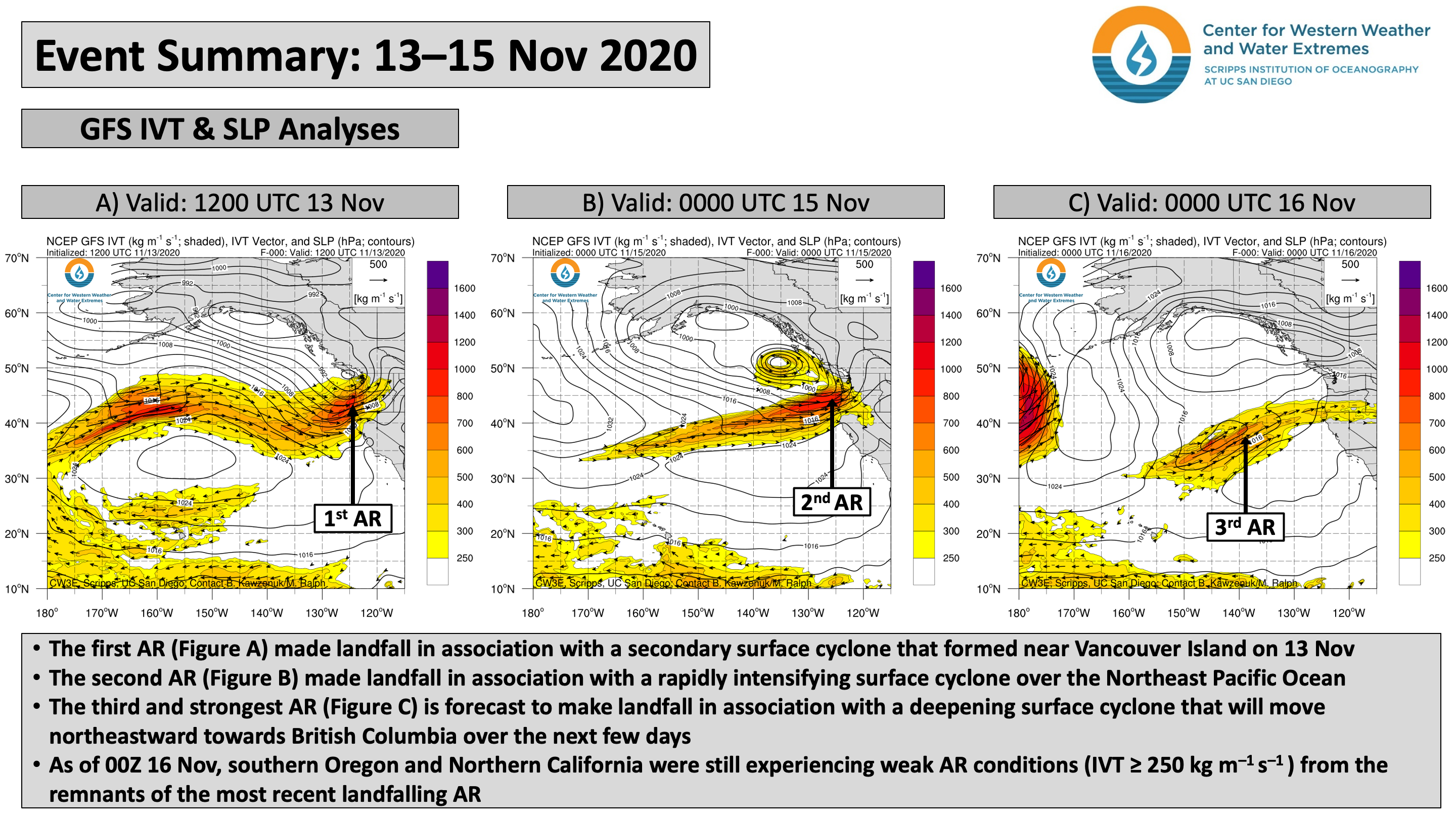
CW3E Publication Notice
The Observed Water Vapor Budget in an Atmospheric River over the Northeast Pacific
November 16, 2020
Joel Norris, Professor of Climate and Atmospheric Sciences at Scripps Institution of Oceanography and CW3E affiliate, recently published a paper in the Journal of Hydrometeorology along with co-authors including F. Martin Ralph, CW3E Director, Reuben Demirdjian, recently graduated CW3E PhD student, CW3E scientist Forest Cannon, and CW3E affiliate Duane E. Waliser of NASA’s Jet Propulsion Laboratory, among others (Norris et al., 2020). This study contributes to the goals of CW3E’s 2019-2024 Strategic Plan to support Atmospheric River (AR) Research and Applications by furthering our understanding of AR dynamics.
Observing and understanding the processes controlling the water budget of an AR offshore will help us better understand what factors lead to an increase in AR’s Integrated Water Vapor (IWV) content and how much water vapor will be available for precipitation when the AR makes landfall. This is particularly important for water supply and flood risk management, as substantial precipitation and flooding can occur when ARs make landfall in many regions across the world. Observational campaigns, such as those described in this study, are crucial to understanding the processes that modulate IWV. Specifically, lack of budget closure in reanalyses indicates that it is necessary to observationally quantify the magnitudes of precipitation and the dynamical convergence of water vapor and their offsetting contributions to IWV tendency in the AR core.
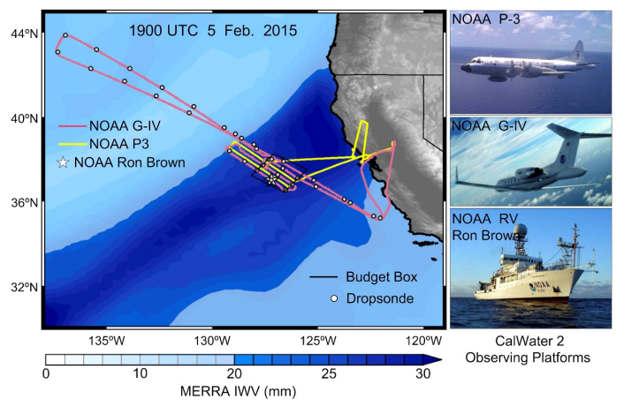
This study uses CalWater2 observations of an AR event on 5 February 2015 collected from the NOAA G-IV and the NOAA R/V Ron Brown (Fig 1) to derive a spatial estimate of precipitation over a ~24,000 km2 oceanic domain off the coast of California. Calculating water vapor budget terms for subregions within the larger budget region allows additional physical insight into the processes controlling the AR’s IWV content. In this specific case, the IWV tendency over the entire domain was dominated by dynamical convergence, and evaporation was negligible. However, the results reveal the substantial spatial variability present in IWV convergence and precipitation at scales of ~50km (Fig 2).
The Norris et al. (2020) study was innovative in many ways. First, precipitation was observationally estimated by conversion of NOAA G-IV tail doppler radar reflectivity to rain rate using a Z-R relationship derived from shipboard disdrometer measurements on the same day. Second, this study documented precipitation, dynamical convergence, and advection for subregions of the main budget domain corresponding to different combinations of dropsonde subsets. And third, this study demonstrated that the water vapor budget of the main region could be observationally closed. The results have implications for our understanding of processes in the frontal sector of ARs, currently a primary source of uncertainty in IWV tendency.
Figure 1. Left: Flight tracks of NOAA G-IV (pink) and NOAA P-3 (yellow), locations of NOAA RHB (star) and dropsondes (circles), and boundary of water vapor budget region (black polygon), all overlaying MERRA-2 IWV for 1900 UTC 5 February 2015 (mm, color scale at bottom). Right: photos of the observing systems. (Figure 1 from Norris et al., 2020)
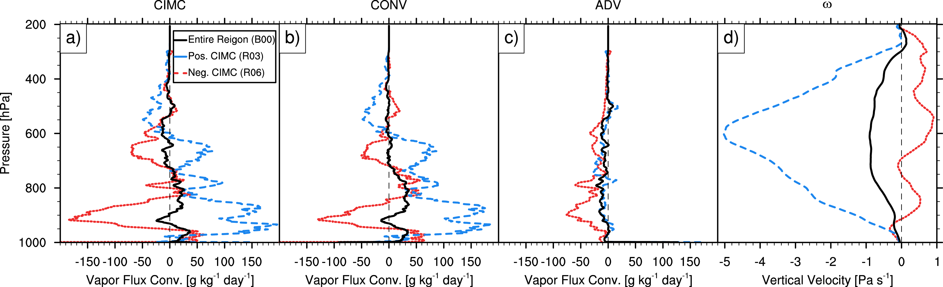
Figure 2. Kinematic diagnostic profiles derived from the G-IV dropsondes comprising the entire budget region (B00, black) and subregions with the most positive CIMC (R03, dashed blue) and most negative CIMC (R06, dotted red) , as defined in Fig. 10 and Table 4 (see publication): (a) mass-balanced horizontal moisture convergence (g kg-1 day-1), (b) mass-balanced change in moisture from horizontal dynamical convergence (g kg-1 day-1), © mass-balanced horizontal moisture advection (g kg-1 day-1), and (d) pressure vertical velocity (Pa s-1). (Figure 11 from Norris et al., 2020).
Norris, J.R., F.M. Ralph, R. Demirdjian, F. Cannon, B. Blomquist, C.W. Fairall, J.R. Spackman, S. Tanelli, and D.E. Waliser, 2020: The Observed Water Vapor Budget in an Atmospheric River over the Northeast Pacific. J. Hydrometeor., 21, 2655-2673, https://doi.org/10.1175/JHM-D-20-0048.1.