CW3E Welcomes Dr. Agniv Sengupta

CW3E Welcomes Dr. Agniv Sengupta

February 3, 2022

Dr. Agniv Sengupta joined CW3E as a Subseasonal-to-Seasonal (S2S) Scientist in January 2022. His research interests broadly span across climate dynamics, hydroclimate variability, prediction, and predictability, with particular emphasis on the application of artificial intelligence and machine learning methods in geophysical data analysis. Prior to joining CW3E, Agniv was employed at the NASA Jet Propulsion Laboratory (JPL) as a postdoctoral scholar under the supervision of Dr. Duane Waliser (2020-2021). At JPL, his research focused primarily on leveraging sources of predictability at longer lead times for the development and dissemination of seasonal winter precipitation forecasts over the western United States using novel statistical and machine learning methods. In the interest of supporting the upcoming Fifth U.S. National Climate Assessment Report, Agniv also investigated the representation of the global and regional water cycle in climate model simulations. Before moving to California, Agniv received his Ph.D. (2020) and M.S. (2016) in Atmospheric and Oceanic Science from the University of Maryland (UMD) at College Park. His doctoral research at UMD was focused on sea-surface temperature based statistical forecasting of the South-Southeast Asian summer monsoon rainfall. Agniv’s M.S. thesis involved an attribution analysis of the evolution of the 2015-16 El Niño episode.

At CW3E, Agniv will serve as the lead for the Machine Learning Team, whose activities include advancing models for predictions at weather and S2S timescales, development of decision support tools, and interpretable learning. He will leverage his background in climate dynamics to further the Center’s goal of improving the S2S prediction skill over the western United States and develop forecast products in coordination with stakeholders.

CW3E Publication Notice: Improved Forecast Skill through the Assimilation of Dropsonde Observations from the Atmospheric River Reconnaissance Program

CW3E Publication Notice

Improved Forecast Skill through the Assimilation of Dropsonde Observations from the Atmospheric River Reconnaissance Program

January 18, 2022

Minghua Zheng, CW3E data assimilation researcher, along with other researchers from CW3E (Luca Delle Monache, F. Martin Ralph, Zhenhai Zhang, Laurel Dehaan), NOAA/NCEP/EMC (Xingren Wu and Vijay Tallapragada), Scripps (Bruce Cornuelle, Jennifer S. Haase, and Michael Murphy), and the University of Colorado at Boulder (Aneesh Subramanian and Timothy Higgins), published a paper in Journal of Geophysical Research: Atmosphere, titled “Improved Forecast Skill through the Assimilation of Dropsonde Observations from the Atmospheric River Reconnaissance Program” (Zheng et al. 2021). As part of CW3E’s 2019-2024 Strategic Plan to support Atmospheric River Research and Applications and Emerging Technologies, CW3E seeks to establish CW3E as a leading center for data assimilation tailored to predicting precipitation, ARs, and extreme events in the West. This study assesses the impact of AR Reconnaissance (Recon) dropsonde data collected during 2016, 2018, and 2019.

During the winter seasons of 2016, 2018, and 2019, 15 Intensive Observation Periods (IOPs) sampled the upstream conditions for landfalling ARs to better understand and reduce forecast errors of the US West at 1-5–day lead times. In order to evaluate the impact on forecast accuracy of assimilating these dropsonde data, data denial experiments with (WithDROP) and without (NoDROP) dropsonde data were conducted using the Weather Research and Forecasting model with the Gridpoint Statistical Interpolation four‐dimensional ensemble variational system. The high-resolution predictions from these experiments are compared to the ERA-5 reanalysis data across the western United States and Eastern Pacific domain as well as the Stage-IV precipitation over the western United States between 110°W-125°W.

Comparisons between the 15 paired NoDROP and WithDROP experiments demonstrate that AR Recon dropsondes have reduced the root-mean-square error in integrated vapor transport (IVT) (Figure 1) and inland precipitation (Figure 2) for more than 70% of the IOPs, averaged over all forecast lead times from 1 to 6 days. Dropsondes have improved the spatial pattern of forecasts of IVT and precipitation in all 15 IOPs (Figures 1-2). Significant improvements in skill are found beyond the short-range (1-2 days). IOP sequences (i.e., back-to-back IOPs every other day) show the most improvement of inland precipitation forecast skill (Figure 2). The Fractions Skill Score (FSS), a neighborhood method, was also employed to objectively assess the spatial skill at different scales of precipitation forecasts for comparing the NoDROP and WithDROP experiments. The FSS results highlight that AR Recon dropsondes are more important when the precipitation forecast has poorer skills, specifically with a higher precipitation threshold (see Figure 12 in Zheng et al. 2021 for more details).

This study has demonstrated the importance of AR Recon dropsondes in improving model initial conditions and the predictions of both the AR and the associated precipitation with an advanced data assimilation method. While there is still work to be done to optimize the assimilation process, this work shows that these high-accuracy and high-vertical-resolution observations bring unique direct information about meteorological variables to the numerical weather models, particularly over cloudy and precipitating areas. This work also supports ongoing Atmospheric River Reconnaissance operations.

Figure 1: (Figure 9 in Zheng et al. 2021) Boxplot of RMSE (a, c) and error-difference correlation (b, d) for IVT w.r.t. the ERA5 data over the common verification area (105°W-165°W, 15°N-60°N) based on the forecast hour (a, b) and the individual IOPs (c, d). The box plot graphically depicts the range of values for the 15 IOPs in (a-b) and the 25 lead times in (c-d) as follows: the top and bottom edges of the box indicate the top and bottom quartiles, the centerline in the box denotes the median and the whiskers at the top and bottom extend to the most extreme data points, which are no more than 1.5 times the interquartile range from the box. The green and red numbers on each panel represent improved IOPs or lead times and degraded IOPs or lead times, respectively.

Figure 2: (Figure 11 in Zheng et al. 2021) RMSE and error-difference correlation for common area (110°W-125°W, 30°N-50°N) verification for precipitation based on the forecast hour (a, b) or IOPs (c, d). The green and red numbers on each panel represent improved IOPs or lead times and degraded IOPs or lead times, respectively.

Zheng, M., Delle Monache, L., Cornuelle, B.D., Ralph, F.M., Tallapragada, V.S., Subramanian, A.,
Haase, J.S., Zhang, Z., Wu, X., Murphy, M.J. and Higgins, T.B., 2021. Improved Forecast Skill through the Assimilation of Dropsonde Observations from the Atmospheric River Reconnaissance Program. Journal of Geophysical Research: Atmospheres, 126(21), p.e2021JD034967. doi: https://doi.org/10.1029/2021JD034967

CW3E Publication Notice: Large-scale environments of successive atmospheric river events leading to compound precipitation extremes in California

CW3E Publication Notice

Large-scale environments of successive atmospheric river events leading to compound precipitation extremes in California

January 13, 2022

Recent CW3E PhD graduate student, Dr. Meredith Fish, along with co-authors Dr. James M. Done (Capacity Center for Climate and Weather Extremes, National Center for Atmospheric Research), Dr. Daniel Swain (Institute of the Environment and Sustainability, University of California, Los Angeles), Dr. Anna M. Wilson (Center for Western Weather and Water Extremes (CW3E), Scripps Institution of Oceanography, University of California San Diego), Dr. Allison C. Michaelis (Department of Geographic and Atmospheric Sciences, Northern Illinois University), Dr. Peter B. Gibson (CW3E; National Institute of Water and Atmospheric Research, New Zealand), and Dr F. Martin Ralph (CW3E), recently published an article in Journal of Climate, titled “Large-scale environments of successive atmospheric river events leading to compound precipitation extremes in California”. The paper contributes to the goals of CW3E’s 2019-2024 Strategic Plan to support Atmospheric River (AR) Research and Applications by examining the large-scale environments and mechanisms associated with these successive Atmospheric River (AR) events, known as AR families.

This study utilizes a new reanalysis-based 39-year catalog of 248 AR family events affecting California between 1981 and 2019 to evaluate the large-scale conditions linked to these
successive events and their relationship to precipitation along the U.S. West Coast. In evaluating this dataset, the study seeks to 1) understand the characteristics of AR families and their causative processes, 2) to examine relationships between AR families and modes of climate variability, and 3) to quantify the precipitation accumulation associated with AR families.

Using K-means clustering on the 500-hPa geopotential height field, Fish et al. identify six distinct clusters of large-scale patterns associated with AR families (Figure 1). Two clusters are of particular interest due to their strong relationship with phases of the El Niño/Southern Oscillation (ENSO). One of these clusters is characterized by a strong ridge in the Bering Sea and Rossby wave propagation, most frequently occurs during La Niña and neutral ENSO years and is associated with the highest cluster-average precipitation across California. The other cluster, characterized by a zonal elongation of lower geopotential heights across the Pacific basin and an extended North Pacific Jet, most frequently occurs during El Niño years and is associated with lower cluster-average precipitation across California but a longer duration. In contrast, Fish et al. find that single AR events do not show obvious clustering of spatial patterns. This difference presented by the study suggests that the potential predictability of AR families may be enhanced relative to single AR events, especially on sub-seasonal to seasonal timescales.

The results from this study enhance understanding of the large-scale variability relevant to successive AR events affecting California, which has previously gone largely unexplored. Given that many of these events produce extreme precipitation, these findings present important implications for water and flood management, and meteorological and hydrologic hazard mitigation.

Figure 1: K-means clustering (k=6) on anomalous 500-hPa geopotential heights (shaded, m) for
all timesteps within AR families. Cluster 1: n=1524, Cluster 2: n=2058, Cluster 3: n=911, Cluster 4: n=1681, Cluster 5: n=1160, Cluster 6: n=990.

Fish, M.A., Done, J.M., Swain, D.L., Wilson, A.M., Michaelis, A.C., Gibson, P.B., Ralph, F.M. (2021). Large-scale environments of successive atmospheric river events leading to compound precipitation extremes in California. Journal of Climate. https://doi.org/10.1175/JCLI-D-21-0168.1

CW3E Publication Notice: A Climatology of Narrow Cold-Frontal Rainbands in Southern California

CW3E Publication Notice

A Climatology of Narrow Cold-Frontal Rainbands in Southern California

January 13, 2022

Click here to access the article.

Narrow cold-frontal rainbands (NCFRs) are mesoscale features (fine-scale features, typically a few to tens of kilometers in spatial extent and lasting hours) that are embedded within extratropical cyclones, and can produce short-duration, high-intensity precipitation capable of triggering flash flooding or debris flows. Research related to NCFRs spans several decades and numerous case studies of these events have been used to improve understanding related to their development and evolution, forecasting, and impacts to affected communities (Cannon et al., 2020, Jorgensen et al., 2003, Houze et al., 1976, Sukup, 2016). Southern California is one such impacted region, where in 2017 a NCFR lead to the issuance of multiple warnings by local National Weather Service offices (Figure 1), and in 2018 where a NCFR passed over the Thomas Fire burn scar in Santa Barbara County, causing disastrous and deadly debris flows (Oakley et al. 2018). In an effort to create a comprehensive understanding of how these features have affected Southern California, we created a climatological record of these events manually using rain gauge observations and NEXRAD weather radar reflectivity imagery.

For the October-May period of years 1995-2020 we identified 94 individual NCFRs within the Southern California Bight, with as few as 0, as many as 10, and an average of 3 events occurring per water year, with a majority occurring in the late fall and winter months. Using atmospheric reanalysis, we identified common large-scale meteorological ingredients for NCFR events, including a low-pressure system off of the US West Coast, a decreasing sea level pressure tendency off the coast of Southern California, and an integrated water vapor maxima accompanied by an upper-level jet streak exit region within the study domain. Radar reflectivity composites of NCFR events suggest San Diego County sees more frequent intense landfalling NCFRs as compared to the rest of Southern California, though future work is needed to verify this is not a bias in radar observation. Additional results related to the movement characteristics of a sub-sample of events show that individual NCFR cores tend to move towards the east at an average speed of 14 m/s. Relationships between the identified NCFRs and National Weather Service Warnings reveal that although numerous events (45) are associated with at least one flash flood, severe thunderstorm, or tornado warning, only a small number of extreme NCFR events (15) are associated with many (>10) warnings.

This research supports the CW3E goal of advancing the understanding and projections of extreme precipitation events by laying the foundation for deeper dives into how NCFRs impact Southern California and how to improve forecasting of these events. The regional NCFR catalogue developed provides a large set of events that can be used to examine how numerical weather prediction models represent these mesoscale systems, especially in the presence of complex topography, which is found throughout Southern California. In addition, the NCFR catalogue provides a novel training dataset that can be used to develop an automated detection algorithm for NCFRs using radar reflectivity data. NCFRs have been shown to be impactful precipitation events in Southern California and other mid-latitude regions of the world associated with forecast uncertainty, motivating the need to allocate further effort towards understanding and forecasting them. Broadly, the work presented here, as well as future work, may be applied to other mid-latitude regions that are affected by extratropical cyclones and where radar data are available.

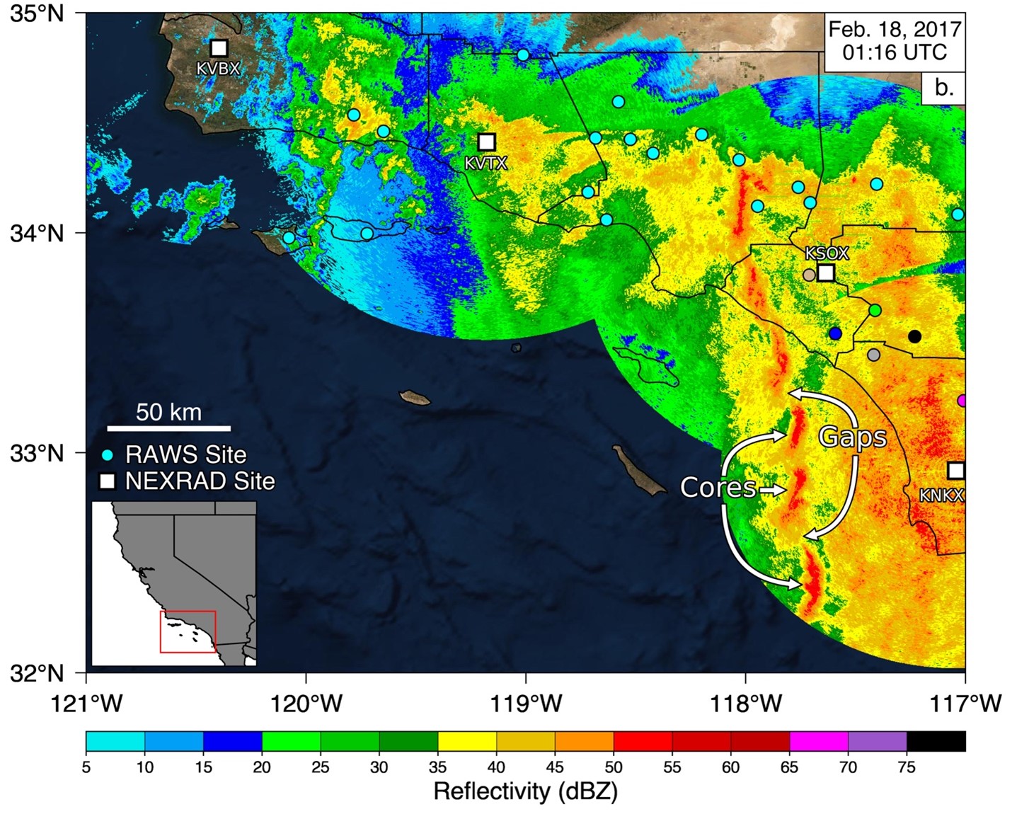
Figure 1: Radar reflectivity of a Narrow Cold-Frontal Rainband impacting Southern California on February 18, 2017. Orange-to-red colors indicate areas of higher intensity rainfall while blue to green colors indicate areas of lighter rainfall. Non-cyan colored circles indicate remote automatic weather station (RAWS) sites that correspond to the precipitation time series shown in the manuscript. Also note the classic gap and core structure, where high intensity cores are located adjacent to low intensity gap regions.

de Orla-Barile, M., Cannon, F., Oakley, N. S., & Ralph, F. M. (2022). A climatology of narrow cold-frontal rainbands in Southern California. Geophysical Research Letters, 49, e2021GL095362. https://doi.org/10.1029/2021GL095362

References

Cannon, F., Oakley, N. S., Hecht, C. W., Michaelis, A., Cordeira, J. M., Kawzenuk, B., Demirdjian, R., Weihs, R., Fish, M. A., Wilson, A. M., Ralph, F. M., (2020). Observations and predictability of a high-impact narrow cold-frontal rainband over Southern California on 2 February 2019. Weather Forecasting, 1-40

Houze, R. A., Hobbs, P. V., Biswas, K. R., & Davis, W. M. (1976). Mesoscale Rainbands in Extratropical Cyclones. Monthly Weather Review, 104(7), 868–878. https://doi.org/10.1175/1520-0493(1976)104<0868:MRIEC>2.0.CO;2

Jorgensen, D. P., Pu, Z., Persson, P. O. G., & Tao, W.-K. (2003). Variations Associated with Cores and Gaps of a Pacific Narrow Cold Frontal Rainband. Monthly Weather Review, 131(11), 2705–2729. https://doi.org/10.1175/1520-0493(2003)131<2705:VAWCAG>2.0.CO;2

Oakley, N. S., Cannon, F., Munroe, R., Lancaster, J. T., Gomberg, D., & Ralph, F. M. (2018b). Brief Communication: Meteorological and Climatological Conditions Associated with the 9 January 2018 Post-Fire Debris Flows in Montecito and Carpinteria, California, USA. Natural Hazards and Earth System Sciences, 18(11), 3037–3043. https://doi.org/10.5194/nhess-18-3037-2018

Sukup, S., Laber, J., Sweet, D., & Thomson, R. (2016). Analysis of an intense narrow cold frontal rainband and the Springs Fire burn area debris flows of 12 December 2014 (NWS Technical Attachment 1601). Los Angeles/Oxnard, CA: National Weather Forecast Office. Retrieved from https://www.weather.gov/media/wrh/online_publications/TAs/TA1601.pdf

CW3E Publication Notice: Atmospheric River Reconnaissance Workshop Promotes Research and Operations Partnership

CW3E Publication Notice

Atmospheric River Reconnaissance Workshop Promotes Research and Operations Partnership

January 12, 2022

Anna M. Wilson, along with co-authors Alison Cobb, F. Martin Ralph, Luca Delle Monache, Forest Cannon, Chad Hecht, and Minghua Zheng (Center for Western Weather and Water Extremes, Scripps Institution of Oceanography), Vijay Tallapragada (NOAA/NWS/NCEP/Environmental Modeling Center), Chris Davis (National Center for Atmospheric Research), James Doyle and Carolyn Reynolds (U.S. Naval Research Laboratory), Florian Pappenberger and David Lavers (European Centre for Medium-Range Weather Forecasts), Aneesh Subramanian (University of Colorado, Boulder), Jason Cordeira (Plymouth State University), and Jonathan Rutz (NOAA/NWS/Western Region Headquarters) recently published a paper in Bulletin of the American Meteorological Society. The article, titled “Atmospheric River Reconnaissance Workshop Promotes Research and Operations Partnership”, contributes to the goals of CW3E’s 2019-2024 Strategic Plan to support Atmospheric River (AR) Research and Applications by highlighting the Atmospheric River Reconnaissance (AR Recon) Workshop and its role in promoting research and operations partnerships.

This article presents a summary of the 2021 AR Recon Workshop, a virtual event that brought together AR Recon’s diverse stakeholders to convene several discussions, with the goals of 1) sharing the results of AR Recon data 2) coordinating and inspiring future work on data collection, assimilation, metric development, and impact assessment, and 3) to strengthen the Research and Operations Partnership (RAOP) approach being developed by AR Recon. As Wilson et al. discuss throughout the article, AR Recon observations fill critical gaps in the traditional observation system, enabling advances in the understanding of physical processes that modulate AR characteristics. The 2021 AR Recon Workshop provided a specific opportunity for the group to take time to highlight both accomplishments and lessons learned from the prior season, prepare for the next season, share key results from data impact studies, and develop coordinated case study approaches. The workshop also enabled discussions about the future, the exploration of collaborative opportunities to learn more about the physical processes, and refinements in targeting strategies aimed at improving the representation of atmospheric initial conditions in operational NWP models. Scientific discussion ranged between topics including 2021 AR Recon observations, available forecasting tools, essential atmospheric structures (Figure 1), and impacts of AR Recon data on forecasts.

The outcomes of the AR Recon Workshop highlighted by Wilson et al. showcase the program’s role as a successful RAOP, bringing diverse stakeholders together, developing opportunities for collaborative research partnerships, improving forecast accuracy for the U.S. West Coast, and providing a case study for further application.

Figure 1: Schematic of physical targets for AR Recon.

Wilson, A. M., Cobb, A., Ralph, F. M., Tallapragada, V., Davis, C., Doyle, J., Delle Monache, L., Pappenberger, F., Reynolds, C., Subramanian, A., Cannon, F., Cordeira, J., Haase, J., Hecht, C., Lavers, D., Rutz, J. J., & Zheng, M. (2021). Atmospheric River Reconnaissance Workshop Promotes Research and Operations Partnership, Bulletin of the American Meteorological Society (published online ahead of print), https://doi.org/10.1175/BAMS-D-21-0259.1

CW3E Welcomes Colin Grudzien

CW3E Welcomes Colin Grudzien

January 11, 2022

Dr. Colin Grudzien joins CW3E as a Data Assimilation Scientist in January, 2022. Colin received his BS in Mathematics and History from the University of Oregon in 2011 and his PhD in Mathematics from the University of North Carolina at Chapel Hill in 2016. In his PhD, Colin was a graduate research assistant for the Mathematics and Climate Research Network (MCRN), a virtual organization that was designed to connect mathematicians with geoscientists in order to develop interdisciplinary research programs and collaborations. As a graduate research assistant for MCRN, Colin organized an online data assimilation seminar which included partners in the USA and abroad. During his PhD, Colin completed an internship at the Los Alamos National Laboratory, and was a visiting student at the International Centre for Theoretical Sciences in Bangalore, India, and at the Nansen Environmental and Remote Sensing Center (NERSC) in Bergen, Norway. Colin’s graduate work included studying dynamical systems, partial differential equations, Bayesian inference and model reduction techniques.

Upon completion of his PhD, Colin joined NERSC as a postdoctoral researcher from August 2016 until December 2018, developing stability and robustness criteria for data assimilation schemes in stochastic dynamical systems. Colin’s postdoctoral work included a visiting researcher period at the Centre d’Enseignement et de Recherche en Environnement Atmosphérique (CEREA) in Champs-sur-Marne, France. Following his postdoctoral appointment, Colin was an Assistant Professor of Statistics at the University of Nevada, Reno (UNR) from January 2019 until December 2021, during which time Colin studied the numerical simulation of stochastic dynamical systems and the development of ensemble-variational data assimilation methodology. At UNR, Colin developed undergraduate and graduate coursework in computational statistics and data science, and he was the advisor for the Student Chapter of the Society for Industrial and Applied Mathematics.

Colin now joins CW3E to establish new collaborations, developing novel mathematical, statistical and computational methodology to solve the operational data assimilation problem, to improve the understanding and prediction of atmospheric rivers, and to make an impact on the pressing issue of climate change adaptation in the Western USA. Colin is eager to use his expertise in computational data science at CW3E to further the Center’s mission, to mentor junior scientists, and, as always, he is eager to learn from his colleagues and to expand his research scope. Colin’s professional website, with links to his publications, software and teaching materials, is linked here.

CW3E Event Summary: 2-8 January 2022

CW3E Event Summary: 2-8 January 2022

January 10, 2022

Click here for a pdf of this information.

Long Duration Atmospheric River Brings Heavy Rain and Snow to the Pacific Northwest

  • An atmospheric river (AR) made landfall over Southern Oregon on 2 Jan 2022
  • Over the next few days, the AR stalled, strengthened, and tapped into tropical moisture
  • Two mesoscale frontal waves formed along the AR prolonging AR conditions over the region
  • Many areas along the Oregon and Washington coast experienced AR conditions for at least 48 consecutive hours, resulting in AR 3 and AR 4 conditions (based on the Ralph et al. 2019 AR Scale)
  • More than 10 inches of precipitation fell in portions northwestern Oregon, western Washington, and the Cascade Mountains
  • Several river gauges were near or above flood stage; a portion of Interstate 5 was closed due to flooding along the Chehalis River in Lewis County, WA
  • Multiple feet of snow fell across the Cascade Mountains where avalanches and debris forced several mountain passes to close until conditions improved


Summary provided by S. Roj, C. Castellano, J. Kalansky, F.M. Ralph; January 10, 2022

To sign up for email alerts when CW3E post new AR updates click here.

*Outlook products are considered experimental