Short diagnosis of development of a tropic surge, cut-off low and AR features

Short diagnosis of development of a tropic surge, cut-off low and AR features

December 2, 2014

Storm surge summary (slide 10; M. Ralph)

CW3E director Marty Ralph provides a short diagnosis of an interesting case with a variety of features coming together to generate very large IWV in this currently landfalling storm.

Dr. Ralph notes “This could be a useful event to diagnose more deeply given its relevance to many things we are working on, and the debates about AR, cut-off low, tropical moisture exports, etc. The IVT perspective needs to be explored as well, but the IWV features are quite telling. Jay Cordeira had shared a brief synopsis including a cross-section from GFS that showed the vapor transport over LA maximized at about 3.5 km, which may be more like a ‘tropical moisture export’ structure (Knippertz et al).”

(Please click here for powerpoint slides)

The attached ppt includes an isochrone analysis of the northern edge of the tropical water vapor reservoir (using 4 cm IWV – summary shown above and in slide 10) and its landfall (as seen in the GPS-Met network – slide 11). Also, the snow levels are well-observed with the new SLR network and shows strong north-south variation (slide 12)..

Forecasts are available from the California Nevada River Forecast Center (CNRFC): click here for precipitation forecasts..

Forecasts are also available from the weather service forecast office of the National Weather Service in San Diego: please click here.

CW3E Welcomes Dr. Andrew Martin

CW3E welcomes Dr. Andrew Martin

August 12, 2014

Dr. Andrew Martin has joined the Center for Western Weather and Water Extremes to assist in developing a specialized numerical weather prediction system tailored to predicting extreme precipitation events in the West. Andrew is also actively involved in planning CW3E’s participation in the multi-agency CalWater-2 field campaign. Dr. Martin has a background in aerosols in numerical weather prediction, specifically in cloud microphysics and shortwave radiation models. He received his PhD in meteorology from Florida State University in 2012. Under the direction of T. N. Krishnamurti, Andrew focused on black carbon aerosols and their direct radiative impact on the onset phase of the South Asian summer monsoon. After FSU, Dr. Martin accepted a postdoctoral appointment with Dr. Kim Prather’s group at the University of California, San Diego. Andrew worked with Dr. Prather to support the CalWater project using detailed numerical simulation of the impact of ice nucleating aerosols on North Pacific winter storms, including Atmospheric Rivers. Andrew hails from Albuquerque, NM. The southwestern United States, and the Rocky Mountains in particular, motivated his interest in water resources, mountain winter storms and monsoons. The western environment continues to feed Andrew’s extracurricular interests, which include backpacking, skiing, trail running and bicycling.
CW3E Welcomes Dr. Julie Kalansky

CW3E welcomes Dr. Julie Kalansky

September 28, 2014

Julie joins CW3E as a Post-doctoral scholar after earning her PhD at Rutgers University earlier this year with Yair Rosenthal as her advisor. Her dissertation focused on the relationship between past climate and ocean circulation, and was entitled “Internal and Forced Variability of the Equatorial Pacific on Millennial and Centennial Time Scales”. Using Mg/Ca ratios from microfossils to reconstruct past water column temperatures she showed that the subsurface in the equatorial Pacific is important in storing and transferring heat during climate perturbations. Having grown up in California, she is excited to be back and working on research that is relevant to communities on the West coast. She looks forward to working with her colleagues to study linkages between short-term climate variability and extreme events on the west coast, and to help communicate the importance of atmospheric rivers and the latest scientific findings from CW3E to water managers and the broader community.

CW3E welcomes Dr. David Lavers

CW3E welcomes Dr. David Lavers

September 12, 2016

Dr. David Lavers has joined CW3E at the Scripps Institution of Oceanography to work on improving understanding and forecasting of hydrologic extremes in the western United States. David’s previous research has been in the area of hydrometeorology, with a particular focus on atmospheric rivers (ARs). His work has included studying the connection between ARs and extreme precipitation and flood events across Europe and the Central United States, and investigating how ARs may change in the future. He has previously held appointments at the European Centre for Medium-Range Weather Forecasts, the University of Iowa, Princeton University, and the University of Reading UK. His PhD on seasonal hydrological prediction, awarded in 2011, was undertaken at the Centre for Ecology and Hydrology (Wallingford) UK, and the University of Birmingham UK. Away from work David enjoys outdoor pursuits including hiking and cycling.

Publication Notice: Climatological Characteristics of Atmospheric Rivers and Their Inland Penetration over the Western United States

CW3E Publication Notice

Climatological Characteristics of Atmospheric Rivers and Their Inland Penetration over the Western United States

arhours_full

Mean duration (h) of AR conditions based on IVT250. Histograms of IVT250 ARduration at selected coastal (left) and interior locations (right).

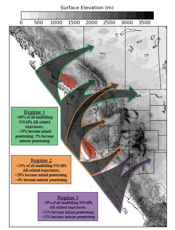
This paper quantifies the climatological frequency and duration of atmospheric rivers (ARs) over the western U.S., as well as the contribution of ARs to heavy precipitation events and cool-season hydroclimate over this region. ARs are objectively identified within reanalysis data based on integrated water vapor transport, which is not only shown to be well-correlated with cool-season precipitation over the West, but also useful for tracking AR penetration from the coast to the interior. Hence, this study lays the groundwork for the development of forecasting tools that will enhance the predictability of ARs and their impacts on the western U.S. This paper presents key findings from a dissertation completed by Jon Rutz at the University of Utah, and is coauthored by his advisor, Jim Steenburgh, and by the CW3E director, F. Martin Ralph. It has also become one of the 10 most-read articles in Monthly Weather Review for the year.

Abstract

Narrow corridors of water vapor transport known as atmospheric rivers (ARs) contribute to extreme precipitation and flooding along the West Coast of the United States, but knowledge of their influence over the interior is limited. Here, the authors use Interim European Centre for Medium-Range Weather Forecasts (ECMWF) Re-Analysis (ERA-Interim) data, Climate Prediction Center (CPC) precipitation analyses, and Snowpack Telemetry (SNOTEL) observations to describe the characteristics of cool-season (November–April) ARs over the western United States. It is shown that AR frequency and duration exhibit a maximum along the Oregon–Washington coast, a strong transition zone upwind (west) of and over the Cascade–Sierra ranges, and a broad minimum that extends from the “high” Sierra south of Lake Tahoe eastward across the central Great Basin and into the deep interior. East of the Cascade–Sierra ranges, AR frequency and duration are largest over the interior northwest, while AR duration is large compared to AR frequency over the interior southwest. The fractions of cool-season precipitation and top-decile 24-h precipitation events attributable to ARs are largest over and west of the Cascade–Sierra ranges. Farther east, these fractions are largest over the northwest and southwest interior, with distinctly different large-scale patterns and AR orientations enabling AR penetration into each of these regions. In contrast, AR-related precipitation over the Great Basin east of the high Sierra is rare. These results indicate that water vapor depletion over major topographic barriers is a key contributor to AR decay, with ARs playing a more prominent role in the inland precipitation climatology where lower or less continuous topography facilitates the inland penetration of ARs.

A personal use copy of the article is available here.

El Nino Impacts and Outlook: Western Region

El Nino Impacts and Outlook: Western Region

October 29, 2014

The Western Regional Climate Center (Kelly Redmond and Nina Oakley) along with NOAA, NIDIS and other western region partners have released a summary discussing El Nino impacts and outlook (October 2014). These brief easy-to-read stories provide a convenient 2-page look at our chances for an El Nino winter and other issues of importance to the western region. Please click here or on the image below to see more.

nino_outlook_western_us_oct2014

Front page of the October 2014 El Nino Outlook and Impacts

Heavy rain in the Pacific northwest

Heavy Rain in the Pacific Northwest

October 27, 2014

Heavy rain struck the Pacific Northwest (Figs. 1, 2) from a series of modest intensity storms, including landfall of embedded atmospheric river conditions (Fig. 3). Precipitation totals during the week of 17-24 October approached or exceeded 10 inches in many of the normally wet mountain locations from northwest Washington to northwest California. One of the largest totals, about 15 inches was in the Olympic Mountains. Although some precipitation fell in the headwaters to reservoirs in northern-most California, there was a sharp southern edge to the heavy precipitation that occurred in northern California.

pacnw_rain_midoct_2014

Fig. 1. Examples of some of the heaviest precipitation in the region from 17 to 24 October 2014.

precip_total_midoct_2014

Fig. 2. 14-day precipitation ending 1200 UTC 25 Oct 2014.

midoct_ar_2014

Fig. 3. A well-defined atmospheric river on 23 October contributed to some of the heaviest precipitation, including sites that received over 5 inches of rain in 24 hours in southwest Oregon and Northwest California around the time of this SSM/I satellite image (courtesy of CIMSS).

The southern end of the AR passed over the Russian River on 25 Oct (Fig. 4) and produced the first rainfall event of the season of over 1 inch accumulation. It lasted about 15 h, roughly half the duration of an average AR in the region. Also, snow was observed on Donner Pass (I-80).

bodgea_arobs_oct2014

Fig. 4. The atmospheric river observatory at Bodega Bay, CA (part of the new state-wide extreme precipitation network sponsored by CA DWR and developed by NOAA and Scripps) documented the passage of the southern end of the first AR of the season in northern California.

The “Northern Sierra 8-Station Index” received roughly 1.2 inches, bringing the season total to 2.7 inches, which is about normal to date for the first 4 weeks of the new water year. More significant precipitation is predicted for the Pacific Northwest in the next week, from 24-31 October 2014 (Fig. 5). Note once again the sharp southern edge to the heavy precipitation, as occurred in the previous week.

precip_7day_qpf_midoct2014

Fig. 5. Precipitation forecast for 24-31 October 2014 courtesy of the National Weather Service.

California Drought: 2013/14 4th driest water year on record

California Drought: 4th driest water year depletes reservoirs

October 1, 2014

CW3E partners at the Sonoma County Water Agency (SCWA) are quoted in a recent article in the Santa Rosa Press Democrat marking water year 2013/14 as the 4th driest on record.

lake_mendocino_30sep2014

The baked lakebed of Lake Mendocino shows a carp head (photo taken 30 September 2014 by Press Democrat photographer Kent Porter)

Dwindling reservoir levels are one of the main concerns due to the drought – Lake Mendocino is only 27% full. The article mentions the research partnership between SCWA and CW3E. Understanding the key role of atmospheric rivers in the area’s water supply is a focus of the research agreement. Please find the full article (including additional photos and a video) at: http://www.pressdemocrat.com/news/2909680-181/north-coast-water-woes-reflected

NASA NEWS program selects joint JPL+CW3E AR proposal

NASA NEWS program selects joint JPL+CW3E AR proposal

August 28, 2014

water_cycle_news

NASA recently announced it selections for its 2013 NASA Energy and Water Cycle (NEWS) solicitation. Included in the selections was a proposal led by Duane Waliser of JPL as PI, and Marty Ralph of CW3E and Bin Guan of UCLA as co-PIs. The proposal aims to study “Atmospheric Rivers: Water Extremes that Impact Global Climate, Regional Weather and Water Resources”, with objectives on observation characterization, including emphasis on atmospheric and terrestrial water budgets, and on the development of methodologies and metrics for model evaluation. The proposal is for a three year study, and funding is expected to start early in FY 2015.

Publication Notice: An Airborne Study of an Atmospheric River over the Subtropical Pacific during WISPAR: Dropsonde Budget-Box Diagnostics and Precipitation Impacts in Hawaii

CW3E Publication Notice

An Airborne Study of an Atmospheric River over the Subtropical Pacific during WISPAR: Dropsonde Budget-Box Diagnostics and Precipitation Impacts in Hawaii

Satellite image swath at 1921 UTC 3 Mar 2011 of IWV (cm; color scale at bottom) from the SSMIS. The unadjusted G-IV flight track is superimposed, along with dots marking the positions and times of the dropsonde releases late on 3 Mar (2007–2343 UTC) and early on 4 Mar (0003–0302 UTC) 2011. The operational rawinsonde locations at Lihue (LIH) and Hilo (ITO) on Hawaii are shown. Manually smoothed satellite-derived sea surface temperatures (8C; contours) from the Reynolds et al. (2007) daily 0.25830.258 resolution optimally interpolated infrared product are also shown. (From Neiman et al. 2014.).

The upcoming CalWater-2 experiment, which is organized by CW3E scientists and others from NOAA, NASA, DOE, USGS and elsewhere, will be using research aircraft to observe atmospheric rivers over the Northeastern Pacific Ocean and U.S. West Coast. This presents an opportunity to measure atmospheric river (AR) structure and embedded physical processes that control the water vapor transport budget. This paper develops some of the key diagnostic tools needed and demonstrates them using a flight pattern and dropsondes designed to calculate the vertical profile of water vapor flux divergence (and other key parameters) in an AR. These tools and associated flight strategies will be critical to future airborne field campaigns that will enable CW3E and colleagues to diagnose key AR-relevant physical processes and to then assess in detail their representation in weather and climate models.

In 2011 a short airborne campaign was conducted to demonstrate the ability of an unmanned aircraft (Global Hawk) to fly over ARs and sample them using dropsondes. As part of this successful demonstration of UAS technology – WISPAR – a special flight of the NOAA G-IV aircraft was also conducted. The paper presents a summary of this flight, including use of drospondes from a box pattern over an AR to calculate vertical profiles of divergence, water vapor flux divergence, sensible heat flux divergence and vertical air motions. The same AR studied here also produced over 10 inches of rain on the normally dry side of the Hawaiian Islands due to the anomalous water vapor transport conditions associated with the AR hitting the region.

Abstract

The Winter Storms and Pacific Atmospheric Rivers (WISPAR) experiment was carried out in January–March 2011 from the National Aeronautics and Space Administration (NASA) Dryden Flight Research Center as a demonstration for utilizing unmanned aerial systems in meteorological research and operations over data-sparse oceans. One of the campaign’s three missions was coordinated with a manned National Oceanic and Atmospheric Administration Gulfstream-IV (G-IV) flight out of Honolulu, Hawaii, on 3–4 March 2011. The G-IV, which flew through a developing atmospheric river (AR) west of Hawaii, represents the cornerstone observing platform for this study and provided the southernmost dropsonde observations of an AR published to date in the subtropical Northern Hemisphere. The AR exhibited characteristics comparable to those observed in previous studies farther north in the subtropics and midlatitudes, save for larger integrated water vapor and weaker winds in the AR core and stronger equatorward vapor fluxes in the shallow post-cold-frontal northeasterly flow. Eight dropsondes released in a ~200-km-wide box formation provided a novel kinematic assessment of tropospheric vorticity, divergence (mass, water vapor, sensible heat), and vertical velocity in the AR region, as well as sea surface fluxes. The budget-box diagnostics were physically consistent with global-gridded reanalysis datasets, while also providing useful additional kinematic and thermodynamic information on the mesoscale. Meteorological impacts of the AR were assessed on Hawaii’s island of Kauai, where the state’s heaviest rainfall was observed for this case. Rainfall on Kauai was modulated significantly by its steep orography, including on the normally dry side of the island where heavy rains fell.

A personal use copy of the article is available here.