The influence of Atmospheric Rivers (ARs) on wet extremes since 1950 are shown by the fraction of AR landfall days (green portion of pie chart). Note, for example, 87% of flood days for the Russian River are AR landfall days.
The Fall 2014 AGU meeting in San Francisco hosted a workshop/press conference describing the upcoming 2015 field campaign: CalWater2 / ARM Cloud Aerosol Precipitation Experiment (ACAPEX). Scientists from Scripps Institution of Oceanography at UC San Diego, the Department of Energy’s Pacific Northwest National Laboratory (PNNL), and NOAA discussed the impetus behind the field campaign to begin in early 2015. The panel described how ground-based, multiple-aircraft, and ship-based measurements will help provide a better understanding of how California gets its rain and snow, how human activities are influencing precipitation, and how the new science provides potential to inform water management decisions relating to drought and flood. One of the related presentations was given by CW3E PI Mike Dettinger. Dr. Dettinger, AGU 2014 Fellow, described historical and future impacts of land-falling ARs. The image above, from his presentation, depicts the influence of AR land-falling days on extreme wet events in California (Russian River floods, flood plain inundations and levee breaks).
Click here for the UCSD/SIO press release about the workshop / press conference.
Click here for the related UCSD/SIO news story about “Refilling California’s Reservoirs—The Roles of Aerosols and Atmospheric Rivers”.
Click here to follow the CalWater-2 / ACAPEX field project forecasts.
Note: the full conference has been postponed to 2016
Atmospheric rivers (ARs) play a key role in the water cycle as the primary mechanism conveying water vapor through mid-latitude regions. The precipitation that ARs deliver in many parts of the world, especially through orographic precipitation proceses, is important for water resources; but it also regularly is a hazard, with floods resulting. The aims of the First International Atmospheric Rivers Conference are
to discuss and identify differing regional perspectives and conditions from around the world,
to evaluate the current state and applications of the science of the mid-latitude atmospheric water cycle, with particular emphasis on atmospheric rivers and associated or parallel processes (e.g., tropical moisture exports),
to assess current forecasting capabilities and developing applications, and
to plan for future scientific and practical challenges.
The conference aims to bring together experts from academia and applications to form a real community of interests. Questions on the table include: What meteorological conditions constitute ARs and what do not? How can ARs (and related processes) best be identified and categorized? What are the most promising new research directions for putting AR science into its proper meteorological/climatological context and improving its applicability?
Additional contributions are now invited from the scientific community
If you have an interest in ARs (or related topics) and an interest in participating please contact the chairs Marty Ralph or Mike Dettinger.
The role of atmospheric rivers in anomalous snow accumulation in East Antarctica
December 4, 2014
Gorodetskaya, I.V., M. Tsukernik, K. Claes, F.M. Ralph, W.D. Neff and N.P.M. Van Lipzig, 2014: The role of atmospheric rivers in anomalous snow accumulation in East Antarctica. Geophysical Research Letters, 41, 6199-6206.
Integrated water vapor (colors) at 00Z on 15 February 2011. Red arrows indicated vertically integrated total moisture transport within the atmospheric river as identified using the definition adapted for Antarctica. Black contours are 500 hPa geopotential heights, where L shows a closed trough at 500 hPa influencing Dronning Maud Land and H shows the blocking high-pressure ridge downstream of the low. White square shows Princess Elisabeth station location. Based on the ERA-Interimm reanalysis.
Understanding changes in the Antarctic ice sheet mass are important for predicting global sea level rise. Recently, East Antarctica gained substantial mass, counterbalancing the increasing ice discharge from West Antarctica in these years. Occasional large snowfall events explained this increased mass load, which has been especially high in 2009 and 2011. Ground-based measurements at the Belgian Antarctic station Princess Elisabeth, established at the ascent to the East Antarctic plateau, have well captured these occasional intense snowfalls and associated snow accumulation responsible for 2009 and 2011 mass anomalies. The question is what has been causing this high accumulation?
Most of the water vapor transforming into the Antarctic snowfall arrives from lower latitudes. We have established that atmospheric rivers explain all extremely high snow accumulation events leading to the mass anomaly at Princess Elisabeth station in 2009 and 2011. These narrow bands of high moisture content have been more known in mid latitudes for their, sometimes catastrophic, impacts, such as heavy precipitation resulting in floods. The atmospheric rivers reaching the Antarctic ice sheet bring a lot of moisture from as far as subtropics and result in intense snowfall when reaching the steep ascent to the Antarctic plateau.
In addition, the work represents a significant advance in the understanding of how the global water cycle is affected by atmospheric rivers by
diagnosing their role in recent Antarctica extreme snowfall events,
developing an AR-detection methodology to track ARs into Polar Regions and
exploring their role in cryospheric processes of importance to global sea level in a changing climate.
Abstract
Recent, heavy snow accumulation events over Dronning Maud Land (DML), East Antarctica, contributed significantly to the Antarctic ice sheet surface mass balance (SMB). Here we combine in situ accumulation measurements and radar-derived snowfall rates from Princess Elisabeth station (PE), located in the DML escarpment zone, along with the European Centre for Medium-range Weather Forecasts Interim reanalysis to investigate moisture transport patterns responsible for these events. In particular, two high-accumulation events in May 2009 and February 2011 showed an atmospheric river (AR) signature with enhanced integrated water vapor (IWV), concentrated in narrow long bands stretching from subtropical latitudes to the East Antarctic coast. Adapting IWV-based AR threshold criteria for Antarctica (by accounting for the much colder and drier environment), we find that it was four and five ARs reaching the coastal DML that contributed 74–80% of the outstanding SMB during 2009 and 2011 at PE. Therefore, accounting for ARs is crucial for understanding East Antarctic SMB.
“And it never failed that during the dry years the people forgot about the rich years and during the wet years they lost all memory of the dry years. It was always that way.” —John Steinbeck, East of Eden, 1962
Heavy rains are predicted for California this week, and after the extreme drought of the past few years, California welcomes the moisture. But can there be too much of a good thing?
While drought is a significant natural hazard Californians must contend with, the natural hazards of severe weather and flooding are equally significant in the feast or famine cycle of storms in California.
Current status of atmospheric river approaching the west coast of the U.S. Credit: Cooperative Institute for Meteorological Satellite Studies (CIMSS), University of Wisconsin-Madison
NOAA’s National Weather Service has issued several watches, warnings, and advisories for across California. Flash floods and high winds are expected in many areas.
Drought is a familiar occurrence in California. Indeed, at a year-to-year or shorter time scale, California has a remarkably variable hydroclimate, experiencing larger year-to-year variations in precipitation than anywhere else in the U.S.
In large part, this extreme variability arises from the small number of storms that provide most of the state’s precipitation each year. If a few large storms happen to bypass California in a given winter, precipitation totals are proportionally much reduced and we risk drought. But the wet, drought-busting months are typically reflections of one or two extremely large storms, with almost half of the large drought-busting storms resulting from landfalling atmospheric rivers or “pineapple expresses.”
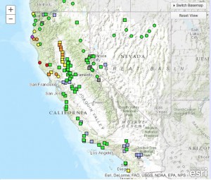
National Weather Service’s Current Flood Forecast for California rivers. Orange, red and purple dots indicate minor to major flooding. Green dots forecast no flooding.
Atmospheric Rivers (ARs) are constantly moving and evolving pathways of water vapor transport that are thousands of kilometers long but only about 500 km wide and that contain large quantities of water vapor and strong winds They are naturally occurring parts of the global water cycle, responsible for more than 90 percent of all atmospheric vapor transport at latitudes of the conterminous United States. When an AR reaches and encounters mountains in the West Coast states, the fast moving, moisture-laden air contained in ARs generally flows up and over the coastal and Sierra Nevada ranges, leading to almost ideal conditions for producing intense and sustained precipitation. Because of the intensity and persistence of their rains, ARs are the cause of many of the most extreme storms along the West Coast and a large majority of the floods in that region.
The Sacramento, California flood of 1862 was the result of atmospheric river storms.
Atmospheric rivers have, in recent years, been recognized as the cause of the large majority of major floods in rivers all along the U.S. West Coast and as the source of 30 – 50 percent of all precipitation in the same region. In terms of droughts in California, about 33 – 40 percent of all persistent drought endings have been brought about by landfalling AR storms, with more localized low-pressure systems responsible for most of the remaining drought breaks.
In 2010, the USGS Science Applications for Risk Reduction (SAFRR) program created an interdisciplinary scenario about large atmospheric river storms in California called ARkStorm. The ArkStorm scenario brought together experts in climate, weather, economics, geography, and other disciplines to create a hypothetical, but scientifically plausible scenario of a future large storm that is providing emergency responders, resource managers, and the public with a realistic example that they can use to determine the possible consequences of a really large AR storm might be.
A new Center at UC San Diego’s Scripps Institution of Oceanography has established a regional effort on atmospheric rivers and other types of extreme weather and water events in the Western U.S. The Center for Western Weather and Water Extremes (CW3E) is developing an “AR Portal” with partners across the nation, including NOAA, California Department of Water Resources, Plymouth State University, and the USGS. The portal brings together advances in AR science, monitoring and prediction, and builds heavily on data from the new AR monitoring network installed across California, and takes unique advantage of existing USGS, NOAA and other monitoring and prediction systems by developing tools tailored to the AR phenomenon.
Pacific Northwest Flooding (slide 3; M. Ralph and L. Schick)
CW3E director Marty Ralph and US Army Corps of Engineers researcher Larry Schick provide a summary of recent flooding in the Pacific Northwest. The heavy precipitation (ending November 28) resulted in an R-CAT 2 event (an event which produces 12-16 inches of precipitation in a 3-day period).
During this event one can see an orographic enhancement of precipitation amounts with a rain “shadow” (low amounts of precipitation) in the Seattle region (slide 2). The heavy precipitation resulted in several streamflow sites exceeding flood stage (shown above; slide 3). The Northwest River Forecast Center had an excellent forecast of peak flow on the Skagit River (slide 4).
Short diagnosis of development of a tropic surge, cut-off low and AR features
December 2, 2014
Storm surge summary (slide 10; M. Ralph)
CW3E director Marty Ralph provides a short diagnosis of an interesting case with a variety of features coming together to generate very large IWV in this currently landfalling storm.
Dr. Ralph notes “This could be a useful event to diagnose more deeply given its relevance to many things we are working on, and the debates about AR, cut-off low, tropical moisture exports, etc. The IVT perspective needs to be explored as well, but the IWV features are quite telling. Jay Cordeira had shared a brief synopsis including a cross-section from GFS that showed the vapor transport over LA maximized at about 3.5 km, which may be more like a ‘tropical moisture export’ structure (Knippertz et al).”
The attached ppt includes an isochrone analysis of the northern edge of the tropical water vapor reservoir (using 4 cm IWV – summary shown above and in slide 10) and its landfall (as seen in the GPS-Met network – slide 11). Also, the snow levels are well-observed with the new SLR network and shows strong north-south variation (slide 12)..
Forecasts are available from the California Nevada River Forecast Center (CNRFC): click here for precipitation forecasts..
Forecasts are also available from the weather service forecast office of the National Weather Service in San Diego: please click here.
Dr. Andrew Martin has joined the Center for Western Weather and Water Extremes to assist in developing a specialized numerical weather prediction system tailored to predicting extreme precipitation events in the West. Andrew is also actively involved in planning CW3E’s participation in the multi-agency CalWater-2 field campaign. Dr. Martin has a background in aerosols in numerical weather prediction, specifically in cloud microphysics and shortwave radiation models. He received his PhD in meteorology from Florida State University in 2012. Under the direction of T. N. Krishnamurti, Andrew focused on black carbon aerosols and their direct radiative impact on the onset phase of the South Asian summer monsoon. After FSU, Dr. Martin accepted a postdoctoral appointment with Dr. Kim Prather’s group at the University of California, San Diego. Andrew worked with Dr. Prather to support the CalWater project using detailed numerical simulation of the impact of ice nucleating aerosols on North Pacific winter storms, including Atmospheric Rivers. Andrew hails from Albuquerque, NM. The southwestern United States, and the Rocky Mountains in particular, motivated his interest in water resources, mountain winter storms and monsoons. The western environment continues to feed Andrew’s extracurricular interests, which include backpacking, skiing, trail running and bicycling.
Julie joins CW3E as a Post-doctoral scholar after earning her PhD at Rutgers University earlier this year with Yair Rosenthal as her advisor. Her dissertation focused on the relationship between past climate and ocean circulation, and was entitled “Internal and Forced Variability of the Equatorial Pacific on Millennial and Centennial Time Scales”. Using Mg/Ca ratios from microfossils to reconstruct past water column temperatures she showed that the subsurface in the equatorial Pacific is important in storing and transferring heat during climate perturbations. Having grown up in California, she is excited to be back and working on research that is relevant to communities on the West coast. She looks forward to working with her colleagues to study linkages between short-term climate variability and extreme events on the west coast, and to help communicate the importance of atmospheric rivers and the latest scientific findings from CW3E to water managers and the broader community.
Dr. David Lavers has joined CW3E at the Scripps Institution of Oceanography to work on improving understanding and forecasting of hydrologic extremes in the western United States. David’s previous research has been in the area of hydrometeorology, with a particular focus on atmospheric rivers (ARs). His work has included studying the connection between ARs and extreme precipitation and flood events across Europe and the Central United States, and investigating how ARs may change in the future. He has previously held appointments at the European Centre for Medium-Range Weather Forecasts, the University of Iowa, Princeton University, and the University of Reading UK. His PhD on seasonal hydrological prediction, awarded in 2011, was undertaken at the Centre for Ecology and Hydrology (Wallingford) UK, and the University of Birmingham UK. Away from work David enjoys outdoor pursuits including hiking and cycling.


