CW3E To Launch Second Year of Experimental Seasonal Forecasts of Precipitation

CW3E To Launch Second Year of Experimental Seasonal Forecasts of Precipitation

September 15, 2020

CW3E researchers Alexander Gershunov and Tamara Shulgina, along with collaborators Kristen Guirguis, Julie Kalansky, Brian Kawzenuk, Mike DeFlorio, and Luca Delle Monache, are set to launch the second year of an experimental seasonal precipitation prediction system based on canonical correlation analysis (CCA) this fall on the CW3E website. The prediction system utilizes a statistical approach that is based on relationships between Pacific Ocean sea surface temperature and precipitation. This effort, sponsored by the U.S. Bureau of Reclamation, California Department of Water Resources, and the U.S. Geological Survey via the Southwest Climate Adaptation Science Center, is part of a broad effort at CW3E to improve subseasonal-to-seasonal (S2S) prediction of precipitation, atmospheric rivers (ARs), and ridging events to benefit western U.S. water resource management. A 2-pager document describing this effort in detail can be found here.

CW3E Explores Shifting Seasons and Precipitation in the Yampa River Basin Upcoming Webinar

CW3E Explores Shifting Seasons and Precipitation in the Yampa River Basin Upcoming Webinar:

Thursday, September 17, 11-12:30 Mountain Time

September 15, 2020

The Yampa River is one of the wildest remaining major tributaries of the Colorado River, and provides crucial water supplies to local stakeholders and to locations as far removed as Arizona and Southern California. A multitude of environmental and societal factors are expected to be affected by climate change in the Yampa River Basin, and are pertinent to other watersheds around the American West.

This summer, CW3E and our partners at Colorado Mountain College, Friends of the Yampa, Yampa Valley Sustainability Council, Steamboat Ski and Resort Corporation, and Vacasa, among others, have virtually come together for the third annual Yampa Basin Rendezvous (YBR). YBR 2020 is a series of four interactive webinars examining the Yampa River Basin through the lens of climate change and seasonal variability. The webinars include talks by regional experts and lively discussions.

The first webinar was held on June 4, 2020, introducing the series and providing an overview of the past year in the Yampa Basin with an eye to this year’s theme of Seasonal Variability. The panelists included Marty Ralph, CW3E Director; Kent Vertrees, with Friends of the Yampa and Steamboat Powdercats; and Nathan Stewart, Associate Professor of Sustainability Studies at Colorado Mountain College.

The second webinar of YBR 2020 was held on July 9, 2020. Webinar 2 was a panel discussion on Changes in Measurement with a Changing Climate, addressing what our measurement data are currently showing and ways we can adapt our strategies to be more effective. The panelists were Mike Dettinger, Visiting Researcher at Scripps Institution of Oceanography; Jeff Deems, Research Scientist with National Snow and Ice Data Center; and Gannet Hallar, Associate Professor of Atmospheric Science at University of Utah. Both the first and second webinars are now available to view online.

This week, on Thursday, September 17th, 11-12:30 (Mountain Time), we will have the third webinar of YBR 2020, hosted virtually on Zoom. The third webinar will delve into the changes we are seeing from shifting seasons and precipitation and how these changes are impacting our local and statewide watershed and forest health. Our panelists will include Russ Schumacher, Associate Professor of Atmospheric Science at Colorado State University, Director of the Colorado Climate Center, and Colorado’s State Climatologist; David Stahle, Distinguished Professor of Geosciences at University of Arkansas; and Courtney Peterson, Adaptive Silviculture for Climate Change (ASCC) Coordinator for the Northern Institute of Applied Climate Science. Register here!

This event is part of a larger effort to connect graduate students, post-doctoral scholars, researchers, staff, and faculty from CW3E to the local communities of river basins throughout the west, to share knowledge regarding climate variability and change that has impacts on the environment, people and the economy.

The second webinar of Yampa Basin Rendezvous 2020 was held on 7 July, 2020.


CW3E AR Update: 14 September 2020 Outlook

CW3E AR Update: 14 September 2020 Outlook

September 14, 2020

Click here for a pdf of this information.

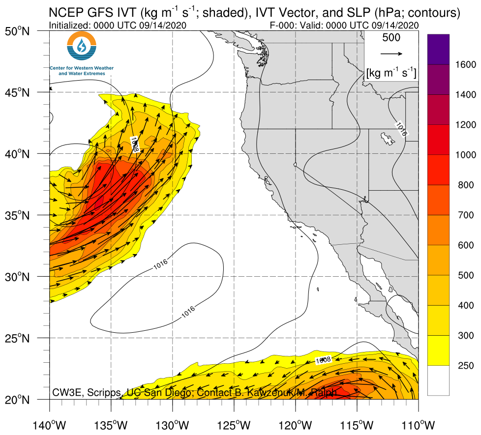
Update on the Atmospheric River forecast to make landfall over the Pacific Northwest

  • An AR that is forecast to make landfall early this week could bring much needed precipitation to parts of Washington, Oregon, and potentially Northern California.
  • As time has progressed closer to verification, ensemble agreement associated with AR landfall timing and initial IVT magnitude has increased.
  • The parent low pressure system is forecast to cut off from the upper-level flow and become quasi-stationary off the PNW coast.
  • Forecast duration of the event is currently exhibiting larger uncertainties as the cut-off low remains off the coast and moves higher IVT magnitudes onshore.
  • Forecast precipitation accumulations from the Weather Prediction Center have primarily decreased since our last outlook, though the ECMWF has trended towards a larger event (max. precip. accumulations of 1.5–2.4 in. over Coastal OR and WA).
  • Forecasts continue to suggest that a majority of CA will remain dry with lighter precipitation rates over far Northern CA.

Click IVT image to see loop of GFS analyses/forecasts

Valid 0000 UTC 14 September – 0000 UTC 24 September 2020


Summary provided by C. Hecht, B. Kawzenuk, C. Castellano, J. Kalansky, and F. M. Ralph; 14 September 2020

*Outlook products are considered experimental

CW3E AR Update: 10 September 2020 Outlook

CW3E AR Update: 10 September 2020 Outlook

September 10, 2020

Click here for a pdf of this information.

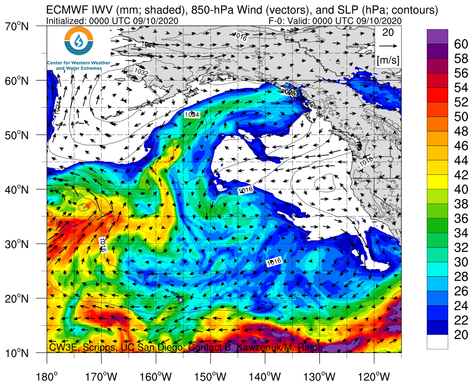
A Landfalling Atmospheric River is Forecast to Potentially Bring Wildfire Relief to the Pacific Northwest

  • An AR that is forecast to make landfall early next week could bring much needed precipitation to parts of Washington, Oregon, and potentially Northern California.
  • Due to large lead times in the forecasts, there is currently very large ensemble and model-to model uncertainties in AR conditions, magnitude, duration, and location.
  • The large forecast uncertainties make it difficult to pinpoint where beneficial and wildfire relieving rains could fall
  • The NOAA Weather Prediction Center is currently predicting as much as 2 inches over Coastal Washington/Northern Oregon, and ~1 inch over far Northern California.

Click IVT or IWV image to see loop of ECMWF analyses/forecasts

Valid 0000 UTC 10 September – 0000 UTC 18 September 2020


Summary provided by C. Hecht, B. Kawzenuk, C. Castellano, J. Kalansky, and F. M. Ralph; 10 September 2020

*Outlook products are considered experimental

CW3E Publication Notice: Forecast Informed Reservoir Operations Using Ensemble Streamflow Predictions for a Multi‐Purpose Reservoir in Northern California

CW3E Publication Notice

Forecast Informed Reservoir Operations Using Ensemble Streamflow Predictions for a Multi‐Purpose Reservoir in Northern California

August 17, 2020

Sonoma Water Engineer Chris Delaney led the development of a forecast informed reservoir operations (FIRO) decision support system, Ensemble Forecast Operations (EFO), for Lake Mendocino with contributions from researchers at CW3E, U.S. Army Corps of Engineers (USACE), NOAA, and independent researchers. This project directly supports the FIRO priority area of CW3E’s 2019-2024 Strategic Plan by describing a crucial tool used in reservoir operations for Lake Mendocino, the first FIRO reservoir. A proof-of-concept EFO model was originally developed by Chris in 2015 as a personal research project, and has been refined over the past 5-years with research and real-time testing and evaluation using major deviation requests made to the USACE. Additionally, the significant evaluation required by the FIRO Preliminary Viability and the Full Viability Assessments, demonstrated that the EFO is a viable alternative for flood control operations at Lake Mendocino. An article documenting the computational processes of EFO has been published in the Water Resources Research scientific journal (Delaney et al., 2020).

EFO is a risk-based approach to reservoir flood control operations that incorporates ensemble streamflow predictions (ESPs) made by the California-Nevada River Forecast Center (CNRFC). Each member of an ESP is individually modeled to forecast system conditions and calculated risk of reaching critical operational thresholds (Fig. 1). Reservoir release decisions are simulated to manage forecasted risk with respect to established risk tolerance levels. EFO was developed for Lake Mendocino, a 111,000 acre-foot reservoir near Ukiah, California, to evaluate its viability to improve reservoir storage reliability without increasing downstream flood risk. Lake Mendocino is a dual use reservoir, owned and operated for flood control by the USACE and operated for water supply by Sonoma Water. EFO was simulated using a 26-year (1985-2010) ESP hindcast generated by the CNRFC, which provides 61-member ensembles of 15-day flow forecasts. EFO simulations yield generally higher storage levels during the flood management season while maintaining needed flood storage capacity by strategically pre-releasing water in advance of forecasted storms. Model results demonstrate a 33% increase in median storage at the end of the flood management season (May 10) over existing operations without marked changes in flood frequency for locations downstream from Lake Mendocino. EFO may be a viable alternative for managing flood control operations at Lake Mendocino that provides multiple benefits (water supply, flood mitigation and ecosystems) and provides a management framework that could be adapted and applied to other flood control reservoirs.

Figure 1. EFO forecasted storage (top panel) and risk (bottom panel) for February 8, 1986.

Delaney, C. J., Hartman, R. K., Mendoza, J., Dettinger, M., Monache, L. D., Jasperse, J., Ralph, F. M., Talbot, C., Brown, J., & Reynolds, D. (2020). Forecast Informed Reservoir Operations Using Ensemble Streamflow Predictions for a Multi‐Purpose Reservoir in Northern California. Water Resources Research, 56, e2019WR026604, https://doi.org/10.1029/2019WR026604.

CW3E Visiting Researcher Honored at California Extreme Precipitation Symposium

CW3E Visiting Researcher Honored at California Extreme Precipitation Symposium

July 21, 2020

The 26th Annual California Extreme Precipitation Symposium (CEPSYM), a Floodplain Management Association project, was held this year on June 30, 2020, virtually due to the ongoing pandemic. Since 2018, CW3E has partnered with CEPSYM to organize the Southwest Extreme Precipitation Symposium, whose purpose is to advance understanding of the causes of and processes within extreme precipitation in the southwest region of North America. This year’s CEPSYM theme was Connecting Rain-on-Snow Events, Atmospheric Rivers, and Floods. Slides from all presentations are available at: https://cepsym.org/proceedings-2020.php

Each year since 2004, a Special Recognition Award is presented to “highlight and honor the outstanding contributions of individuals and institutions that have supported and advanced the professions of meteorology, flood hydrology, and flood risk management. These professions share the public safety goal of protecting life and property from the ravages of flooding. Together these professionals provide the tools, information, and knowledge essential for forecasting flood events before they occur, estimating potential flood magnitudes and impacts used in designing flood risk reduction projects, and responding to floods when they occur. Each honoree contributed to making the people of California safer from flood events over their many years of service.” This year, that award was given to CW3E Visiting Researcher Dr. Michael Dettinger. More details are available on the California Extreme Precipitation Symposium website: https://cepsym.org/awards/dettinger.php

The award presented to Mike Dettinger at the 2020 California Extreme Precipitation Symposium.

CW3E Publication Notice: Floods due to atmospheric rivers along the U.S. West Coast: The role of antecedent soil moisture in a warming climate

CW3E Publication Notice

Floods due to atmospheric rivers along the U.S. West Coast: The role of antecedent soil moisture in a warming climate

July 20, 2020

Graduate student and now UCLA post-doc, Qian Cao, with her advisor, Professor Dennis Lettenmaier and his group, collaborated with CW3E director F. Martin Ralph, and CW3E researchers Alexander Gershunov and Tamara Shulgina on a recently published a paper in the Journal of Hydrometeorology titled “Floods due to atmospheric rivers along the U.S. West Coast: The role of antecedent soil moisture in a warming climate” (Cao et al., 2020). The research aligns with the Monitoring and Projections of Climate Variability and Change Priority Area within CW3E’s 2019-2024 Strategic Plan because it examines atmospheric rivers roles in flooding along the U.S. West Coast.

Precipitation extremes are projected to become more frequent along the U.S. West Coast due to increased atmospheric river (AR) activity, but the frequency of less intense precipitation events may decrease. Antecedent soil moisture (ASM) conditions can have a large impact on flood responses especially if pre-storm precipitation decreases. Taken together with increased antecedent evaporative demand due to warming, this would result in reduced soil moisture at the onset of extreme precipitation events. This article examines the impact of ASM on AR-related floods in a warming climate in three basins that form a transect along the U.S. Pacific Coast: the Chehalis River basin in Washington, the Russian River basin in Northern California, and the Santa Margarita River basin in Southern California (see Figure 1).

They ran the Distributed Hydrology Soil Vegetation Model (DHSVM) over the three river basins using forcings downscaled from 10 Global Climate Models (GCMs). They examined the dynamic role of ASM by comparing the changes in the largest 50, 100 and 150 extreme events in two periods, 1951-2000 and 2050-2099. They used the AR catalogs of Gershunov et al. (2019) in which they applied an automated AR detection scheme to daily GCM output. They found that in the Chehalis (northern-most) basin, the projected fraction of AR-related extreme discharge events slightly decreases. In the Russian basin, this fraction increases, however, and more substantially so in the Santa Margarita basin (see Table 1). This is due to increases in AR-related extreme precipitation events, as well as the fact that the relationship of extreme precipitation to extreme discharge is strengthened by projected increases in year-to-year volatility of annual precipitation in California, which increases the likelihood of concurrent occurrence of large storms and wet ASM conditions.

The research supported herein was funded by the CW3E at the Scripps Institution of Oceanography UC San Diego via AR Program Phase II. Understanding the projected roles of ARs in future flooding is important to building resilience in California.

Figure 1. Map of study region including a) the Chehalis River basin in Washington State, b) the Russian River basin in Northern California, and c) the Santa Margarita River basin in Southern California. The Kling-Gupta efficiency (KGE) during the calibration period (1986-2000) is displayed for each stream gauge in a)-c). d) Location of 60 unregulated coastal watersheds and their hydroclimatic conditions, including e) annual precipitation, f) seasonality of precipitation, and g) max flood ratio. The LOWESS (locally weighted scatterplot smoothing) curve is displayed in e)-g).

Table 1. Fraction [%] of AR-related Peak-Over-Threshold (POT) extreme precipitation events, including POTN1P, POTN2P, and POTN3P events (i.e. extreme precipitation events with thresholds set to 1, 2 and 3 events per year on average), POT extreme discharge events, and annual maximum flow (AMF) events in three river basins based on the ensemble average of 10 GCMs.

Cao, Q., A. Gershunov, T. Shulgina, F.M. Ralph, N. Sun, and D.P. Lettenmaier, 2020: Floods due to atmospheric rivers along the U.S. West Coast: The role of antecedent soil moisture in a warming climate. J. Hydrometeor., https://doi.org/10.1175/JHM-D-19-0242.1 (early view online).

Gershunov, A., T. Shulgina, R.E.S. Clemesha, K. Guirguis, D.W. Pierce, M.D. Dettinger, D.A. Lavers, D.R. Cayan, S.D. Polade, J.F. Kalansky and F.M. Ralph, 2019: Precipitation regime change in Western North America: The role of Atmospheric Rivers. Sci. Rep., 9, 9944, https://doi.org/10.1038/s41598-019-46169-w.

CW3E Publication Notice: Freezing Level Forecast Error Can Consume Reservoir Flood Control Storage: Potentials for Lake Oroville and New Bullards Bar Reservoirs in California

CW3E Publication Notice

Freezing Level Forecast Error Can Consume Reservoir Flood Control Storage: Potentials for Lake Oroville and New Bullards Bar Reservoirs in California

July 20, 2020

CW3E hydrologist, Edwin Sumargo, CW3E researchers, F. Martin Ralph, Forest Cannon and Brian Henn (CW3E alumnus) published a paper in Water Resources Research, titled “Freezing Level Forecast Error Can Consume Reservoir Flood Control Storage: Potentials for Lake Oroville and New Bullards Bar Reservoirs in California” (Sumargo et al., 2020). As part of CW3E’s 2019-2024 Strategic Plan to support Forecast Informed Reservoir Operations, CW3E researches the impacts of atmospheric rivers (ARs) on water management and public safety and to improve the prediction capability. In particular, this study assesses the sensitivities reservoirs in the Yuba-Feather watershed, Lake Oroville and New Bullards Bar reservoirs, to freezing-level (ZFL) forecast uncertainty. Specifically, it quantifies what percentages of the two reservoirs’ flood pools would be consumed by the prescribed ZFL forecast error, with varying ZFL altitudes and precipitation event magnitudes. This study offers a “guide curve” on the reservoir sensitivity to ZFL forecast uncertainty for reservoir operations in the Yuba-Feather watershed. Ultimately, this work supports the ongoing collaborations involving CW3E, Yuba Water Agency, California Department of Water Resources, NOAA, and U.S. Army Corps of Engineers.

The atmospheric ZFL determines the rain‐snow transition zone at the surface, how much rainfall is available for runoff, and the flood risk during a precipitation event (Figure 1). An accurate ZFL forecast is thus critical for reservoir operations, especially in mountain watersheds with narrow elevation bands like the Feather and North Fork Yuba in Northern California, where a 500‐m elevation gain can amount to >50% of the watershed area. Using a ±350‐m ZFL forecast error, we find inflow volume uncertainties of <10% to >50% of the flood pool storages at Lake Oroville and New Bullards Bar reservoirs, depending on the ZFL, antecedent moisture, and the precipitation magnitude (Figure 2). In other words, the uncertainties can increase by up to >3% per inch (25.4 mm) of precipitation, depending on the ZFL and antecedent moisture condition. This result substantiates the significant impact of ZFL forecast error and the critical need of ZFL forecast accuracy to support reservoir flood control operations in the two watersheds.

Figure 1. (Figure 4 in the manuscript) Schematic description of the impact of ZFL forecast uncertainty on (a) storm runoff from the watershed and (b) the associated inflow to reservoir flood pool. The ±350-m ambient ZFL forecast uncertainty in (a) is based on Henn et al. (2020) finding for up to 72-hour forecast lead time, which is used throughout this paper. The 0-500-m downward bending of ZFL over the mountain topography in (a) is based on Minder & Kingsmill (2013) estimate.

Figure 2. (Figure 3 in the manuscript) Feather River (a-c) and North Fork Yuba River (d-f) Watersheds runoff uncertainties associated with a ZFL forecast error of ±350 m in percent of the reservoir flood pool capacities as functions of ZFL and event return periods based on the 1981-2018 daily PRISM precipitation (colors). The top-to-bottom panels represent the runoff uncertainties corresponding to (a and d) dry, (b and e) average, and (c and f) wet antecedent moisture conditions (AMCs). The gray horizontal lines denote the mean, the -1*standard deviation (?) from the mean, and the minimum CNRFC ZFL of the top 10th percentile precipitation events since 2010 (see Appendix A in the manuscript)..

Sumargo, E., Cannon, F., Ralph, F. M., & Henn, B. (2020). Freezing Level Forecast Error Can Consume Reservoir Flood Control Storage: Potentials for Lake Oroville and New Bullards Bar Reservoirs in California. Water Resources Research, 56, e2020WR027072. https://doi.org/10.1029/2020WR027072

CW3E Publication Notice: Forecast Errors and Uncertainties in Atmospheric Rivers

CW3E Publication Notice

Forecast Errors and Uncertainties in Atmospheric Rivers

July 15, 2020

ECMWF scientist and former CW3E postdoc, Dr. David Lavers published an article in May 2020 in Weather and Forecasting. Co-authors included representatives from leading global numerical weather prediction centers, several of whom serve on the AR Recon Modeling and Data Assimilation Steering Committee (as given by asterisks): Bruce Ingleby, David Richardson, Mark Rodwell, and Florian Pappenberger* of ECMWF; Vijay Tallapragada* of NCEP; Jim Doyle* and Carolyn Reynolds* of the Naval Research Laboratory; and multiple key academic partners including Aneesh Subramanian* of CU Boulder, Ryan Torn of SUNY Albany, and CW3E Director F. Martin Ralph*. The collaboration on this article between global operational numerical weather prediction centers and academic institutions is an example of how the Atmospheric River Reconnaissance (AR Recon) Program brings together scientific leaders to leverage airborne observations offshore in and around ARs to support improved forecasts of ARs.

Specifically, this study uses the dropsonde observations collected during the AR Recon campaign and the European Centre for Medium-Range Weather Forecasts (ECMWF) Integrated Forecasting System (IFS) to evaluate forecasts of ARs based upon their temperature, wind, and moisture characteristics. Results show that ECMWF IFS forecasts

  • were colder than observations throughout the troposphere (Fig. 1);
  • were drier and had weaker winds than observations in the lower troposphere, resulting in weaker horizontal water vapor fluxes at low levels (Fig. 1);
  • exhibit an underdispersiveness in terms of the water vapor flux (Fig. 2)

The underdispersiveness in water vapor flux observed in this study largely arises from model representativeness errors associated with dropsondes. To supplement the information provided by the dropsondes, four U.S. West Coast radiosonde sites are assessed and confirm the IFS cold bias throughout the winter season.

The issues identified here are likely to affect the model’s hydrological cycle and hence precipitation forecasts. The diagnosis of model behavior using unique dropsonde observations from AR Recon performed by this study helps better understand ECMWF IFS model performance and errors.

This research supports the goals of two Priority Areas within CW3E’s 2019-2024 Strategic Plan–Atmospheric Rivers Research and Applications, and Emerging Technologies–to produce and improve forecasting and decision support tools that meet the needs of western U.S. forecasters, resource managers, and emergency managers.

Figure 1. Figure 3 in Lavers et al. (2020): Shown are O – B departures (in the EDA control member) averaged in 50-hPa layers at the dropsonde locations for (a) specific humidity, (b) temperature, and (c) wind speed. (d) Observed (gray) and background (red) pressure-level water vapor flux magnitude averaged in 50-hPa layers when interpolating specific humidity on to the wind levels and (e) the O – B departures for water vapor flux. The error bars show the 90% confidence interval of the mean. The number of values in each layer is given on the right-hand side of the panel, and the number used across all layers is shown at the top right of each panel.

Figure 2. Figure 7 in Lavers et al. (2020): The modified spread-error relationship of pressure-level water vapor flux magnitude. The square roots of DepVar (solid), EnsVar (dashed), and EnsVar + ObsUnc2 (dotted) are shown at 0-120-h forecast lead times for (a) 925, (b) 850, and (c) 700 hPa.

Lavers, D.A., N.B. Ingleby, A.C. Subramanian, D.S. Richardson, F.M. Ralph, J.D. Doyle, C.A. Reynolds, R.D. Torn, M.J. Rodwell, V. Tallapragada, and F. Pappenberger, 2020: Forecast Errors and Uncertainties in Atmospheric Rivers. Wea. Forecasting, 35, https://doi.org/10.1175/WAF-D-20-0049.1.

CW3E Publication Notice: Dusty Atmospheric Rivers: Characteristics and Origins

CW3E Publication Notice

Dusty Atmospheric Rivers: Characteristics and Origins

July 15, 2020

An article by Dr. Kara Voss, a newly minted PhD from CW3E, and coauthors from Scripps Institution of Oceanography including Dr. Voss’s adviser Amato T. Evan, Kimberly A. Prather, and CW3E Director F. Martin Ralph has been accepted for publication in Journal of Climate. This research was part of Dr. Voss’s dissertation work, which was funded as part of FIRO and the AR Program, and supports two priority areas (FIRO and Atmospheric River (AR) Research and Applications) within CW3E’s 2019-2024 Strategic Plan.

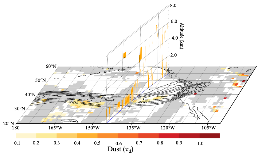
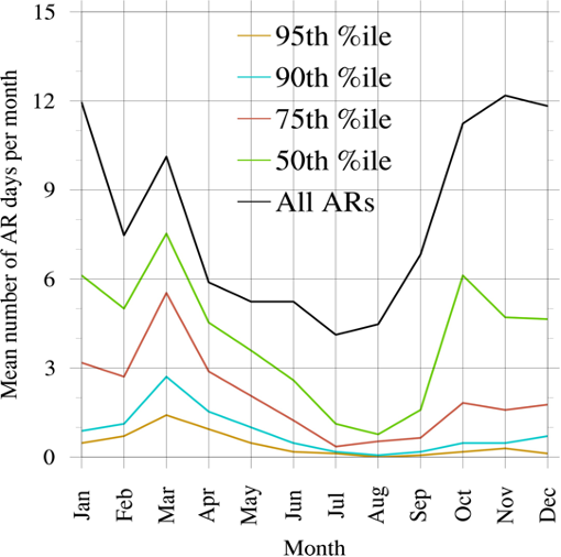
Abstract: The precipitation productivity of an AR is affected by microphysical processes, including the influence of aerosols. Earlier case studies have shown that some ARs over the North Pacific contain dust from Africa and Asia that can strongly influence precipitation by acting as ice nuclei. This paper explores how commonly dust and ARs occur together, or in close proximity (see Figure 1 below). A “dust score” is introduced to characterize the dustiness of the environment associated with ARs using satellite-based observations. This method is applied to days on which one or more ARs made landfall along the west coast of the United States between 2001 and 2018. The dust score is used to describe the seasonality and year-to-year variability of dusty-environment ARs. Dusty ARs occur primarily in the early spring (March-April) (see Figure 2 below) and dust is preferentially found within the warm sector of AR-associated extratropical cyclones. Year-to-year variability in dust score is dependent more on year-to-year variability in dust than on the frequency of AR days. This year-to-year variability is also strongly related to correlations between the frequency of ARs and the dustiness of the northeastern Pacific, motivating additional investigation into potential dynamical association between dust and ARs.

Figure 1: Figure 8 in Voss et al., 2020: Transect from 30 – 50° N near 145° W of CALIPSO Vertical Feature Mask (VFM) dust classification (τd) on 2010-03-29 11:22Z overlaid upon the North Pacific Ocean on that date. The CALIPSO orbital track is shown with a blue line. Contours of IVT greater than 250 kg m—1 s—1 are shown in black.

Figure 2: Figure 11 in Voss et al., 2020: Average number of days each month with ARs making landfall along the contiguous U.S. west coast for the period 2001-2018 grouped by dust-score percentile e.g. AR days with dust score greater than the 90th percentile dust score for the 2001-2018 period fall into the 90th percentile dust score group. ARs with dust scores greater than the 75th percentile dust score occur mostly during the Spring, when the dust season in Asia is at its peak.

Voss, K.K., A.T. Evan, K.A. Prather, and F.M. Ralph, 2020: Dusty Atmospheric Rivers: Characteristics and Origins. J. Climate, 33, 9749-9762, https://doi.org/10.1175/JCLI-D-20-0059.1.