CW3E Welcomes Douglas Alden

CW3E Welcomes Douglas Alden

May 27, 2020

In August 2019, Douglas Alden joined CW3E as full-time Lead Engineer. Douglas had been working in this role part-time since July 2016, splitting his time between the Center and other research as the project lead for Scripps Engineering, Research, and Field Support. He is a UC San Diego alumnus with a degree in Applied Mechanical Engineering Science (1990). His work at CW3E builds on three decades of experience providing engineering and field project management to studies on climate science, atmospheric science and physical oceanography in the US and internationally. Douglas is a Research & Development Engineer 5, and has a strong background in instrumentation design, observational networks, and the challenges of performing field work and collecting data at remote locations worldwide from the ocean bottom to the stratosphere. Douglas’ passion is the application of modern engineering tools to advance our scientific understanding of the world around us.

CW3E Publication Notice: Four Atmospheric Circulation Regimes Over the North Pacific and Their Relationship to California Precipitation on Daily to Seasonal Timescales

CW3E Publication Notice

Four Atmospheric Circulation Regimes Over the North Pacific and Their Relationship to California Precipitation on Daily to Seasonal Timescales

May 26, 2020

CW3E scientist Kristen Guirguis, along with other researchers from CW3E (Alexander Gershunov, Michael DeFlorio, Tamara Shulgina, Luca Delle Monache, Tom Corringham, and F. Martin Ralph) and the University of Colorado at Boulder (Aneesh Subramanian), recently published an article in Geophysical Research Letters entitled “Four atmospheric circulation regimes over the North Pacific and their relationship to California precipitation on daily to seasonal timescales.” Subseasonal-to-seasonal (S2S) predictability of atmospheric rivers and precipitation is a key thematic focus area for CW3E. S2S represents timescales of prediction that are of vital importance to our stakeholders at the California Department of Water Resources. Specifically, this publication helps to further CW3E’s aim to increase understanding and improve skill in forecasting synoptic weather precursor patterns over the western United States that modulate S2S AR and precipitation occurrence and magnitude.

The purpose of this work was to quantify the importance of four atmospheric circulation regimes previously identified in an earlier study (Guirguis et al. 2018) in driving AR activity and precipitation in California. The new study highlights the importance of interactions between these four circulation regimes (called the NP4 modes). In general, when multiple modes align in the positive phase, this reinforces onshore flow patterns over California and is associated with elevated AR activity, heavy precipitation, and historical flooding. Conversely, when multiple modes are jointly negative, this favors upstream atmospheric ridging and dry conditions for California. Seasonally, the study shows how these regimes tend to favor one phase or another in a given water year, which helps to determine if a season is wet or dry. The state of the El Niño Southern Oscillation (ENSO) is shown to stack the deck towards certain phase preferences of the NP4, but within a season there is still much variability, and the probability of extreme precipitation depends on the extent to which the NP4 modes synchronize on daily timescales to reinforce or oppose each other. The study uses multivariate statistical models to quantify the role of the NP4 modes on daily coastal vapor transport and seasonal precipitation in California. The results show the importance of the NP4 modes in driving hydrologic extremes across timescales. An improved understanding of the climate-weather linkages which cause these modes to persist in a season could help to advance S2S predictability.

Figure 1 shows the NP4 atmospheric circulation regimes. Figure 2 shows an example of the reinforcing effect when four modes align in the positive phase (deep trough and enhanced onshore flow, left) or negative phase (strong offshore ridge and anomalous offshore flow, right). Figure 3 shows the effect of joint mode phasing on daily California precipitation.

Figure 1. The NP4 modes shown in the phase associated with enhanced AR activity over California. The color scale gives temporal correlation between the associated principal component time series and 500-mb geopotential height anomalies at a location.

Figure 2. Composites of 500-mb geopotential height anomalies (shaded) and wind speed (vectors) when the NP4 modes are jointly positive (left) or jointly negative (right).

Figure 3. Average daily precipitation conditional on the joint phasing of the NP4 modes. As more modes become aligned in the positive phase, onshore flow is reinforced as in Figure 2 (left).

Guirguis, K., A. Gershunov, M.J. DeFlorio, T. Shulgina, L. Delle Monache, A.C. Subramanian, T.W. Corringham, and F.M. Ralph, 2020: Four North Pacific atmospheric circulation regimes and their relationship to California precipitation on daily to seasonal timescales. Geophys. Res. Lett., 47, e2020GL087609, https://doi.org/10.1029/2020GL087609

CW3E Event Summary: 16-19 May 2020

CW3E Event Summary: 16-19 May 2020

May 21, 2020

Click here for a pdf of this information.

A moderate and seasonally anomalous atmospheric river brought precipitation to a large portion of the Western US

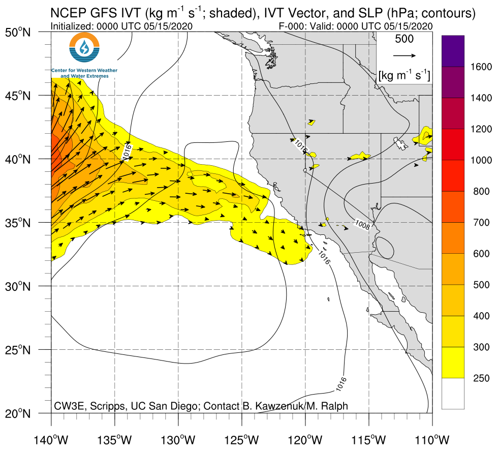
  • Several coastal and inland locations across the Western US experienced AR 1 conditions on the Atmospheric River Scale
  • As much as 6 inches of precipitation fell over high elevation locations in the Sierra Nevada, Cascade, and Rocky Mountains
  • Coastal Sonoma County has only experienced IVT magnitudes greater than 650 kg m–1 s–1 during the later half of May twice since 2000
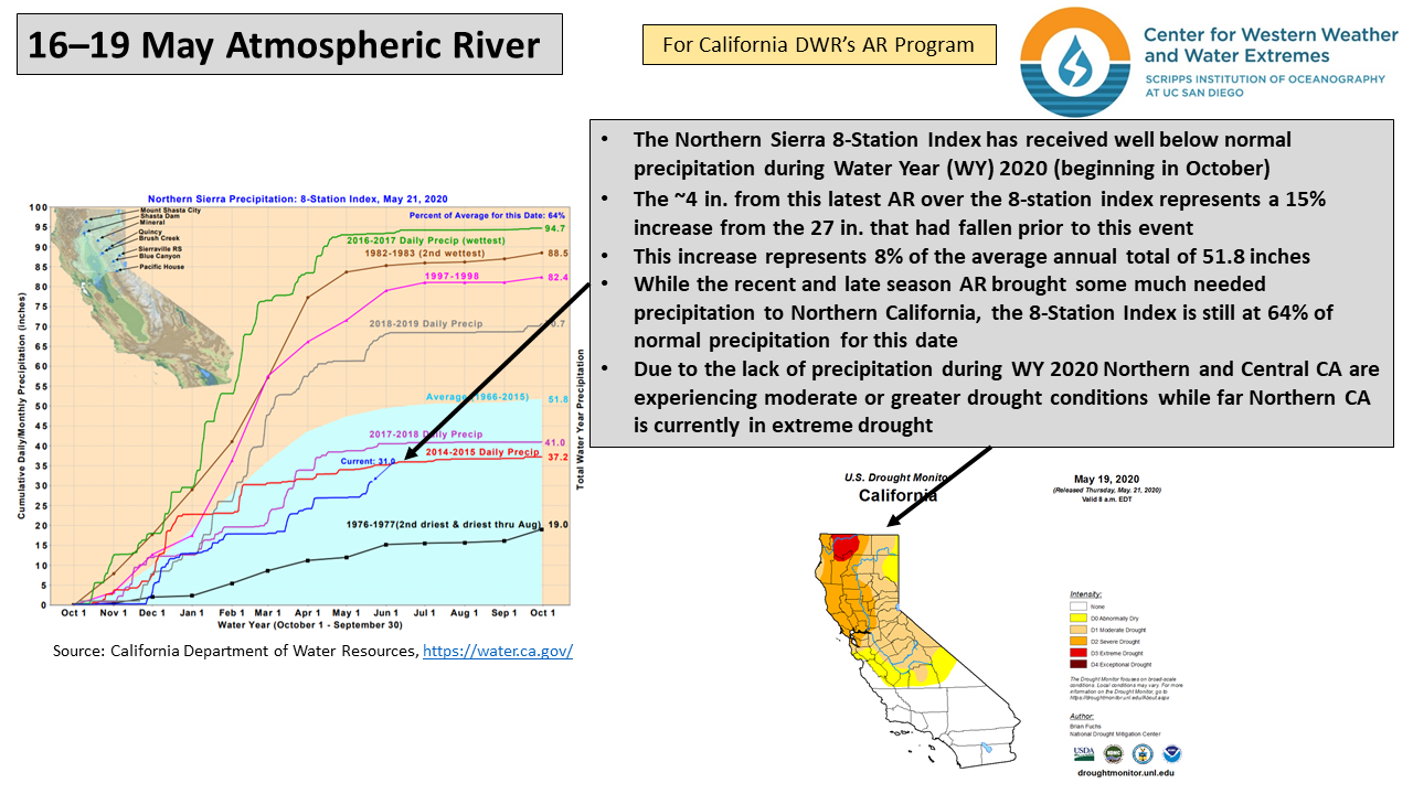
  • While this AR brought much needed precipitation to drought stricken Northern California, the Northern Sierra 8-Station index has only received 64% of its normal precipitation during water year 2020

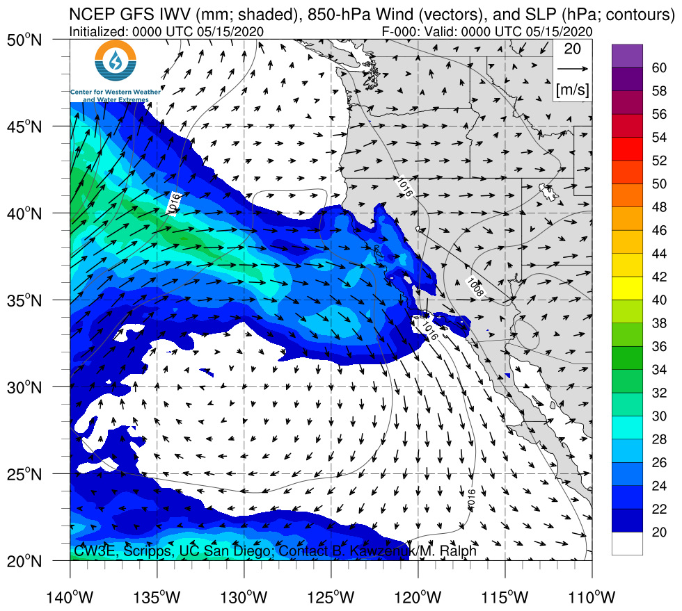
SSMI/SSMIS/AMSR2-derived Integrated Water Vapor (IWV)

Valid 0000 UTC 15 May – 1800 UTC 20 May 2020

Images from CIMSS/Univ. of Wisconsin

Click IVT or IWV image to see loop of GFS Analysis

Valid 0000 UTC 15 May – 1200 UTC 20 May 2020


Summary provided by C. Hecht, B. Kawzenuk, C. Castellano, Z. Zhang, J. Kalansky, and F. M. Ralph; 2 PM PT 21 May 2020

CW3E AR Update: 14 May 2020 Outlook

CW3E AR Update: 14 May 2020 Outlook

April 14, 2020

Click here for a pdf of this information.

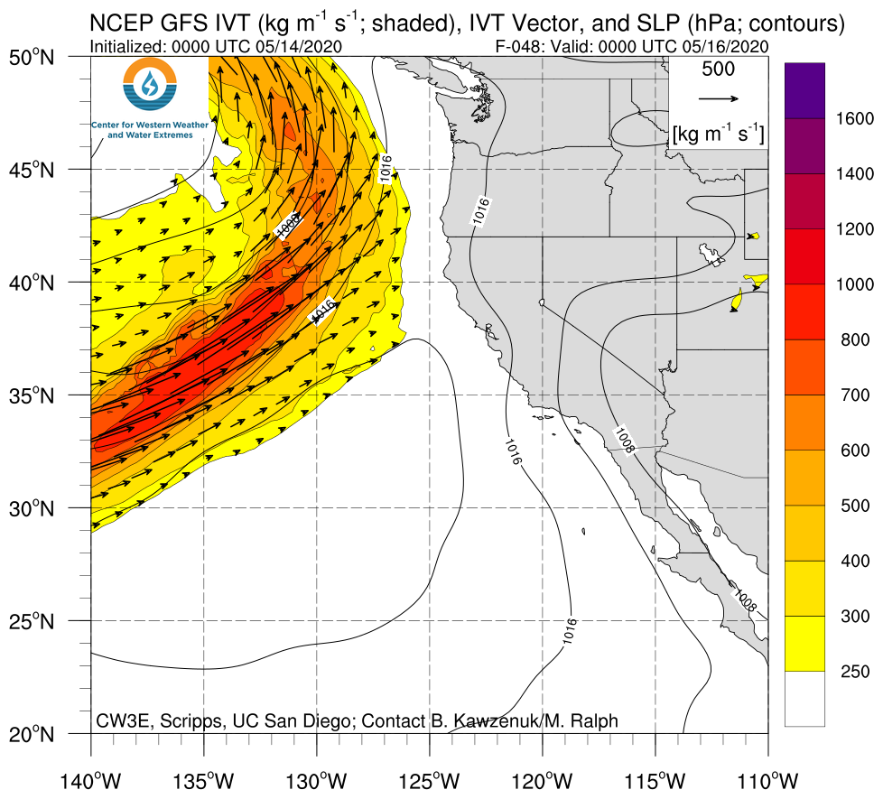
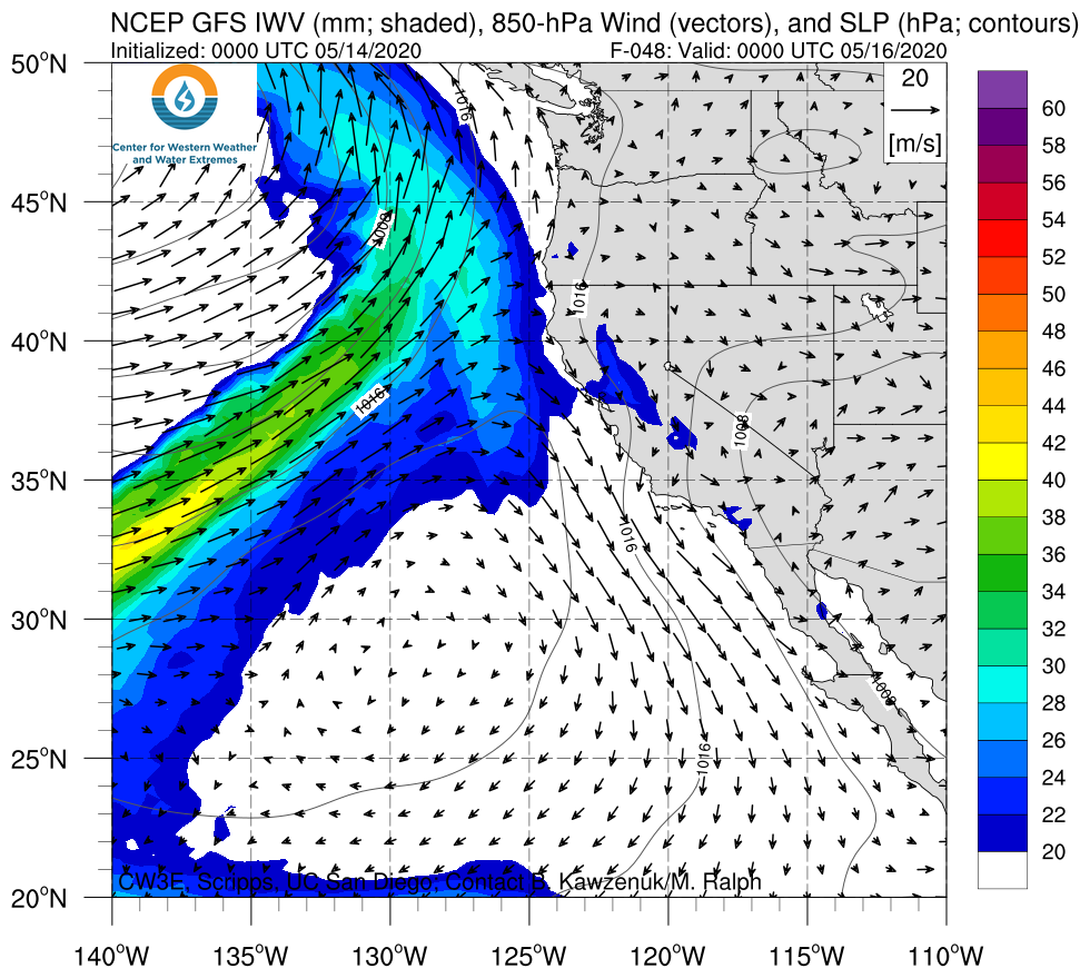
A landfalling AR is expected to bring precipitation to portions of California, Oregon, and the interior Northwestern US

  • An AR associated with a closed upper-level low is forecast to make landfall along the coast of Northern California and Oregon over the next couple of days
  • Interior portions of the western U.S. are expected to experience AR conditions for more than 24 hours
  • The highest precipitation amounts (2–5 inches) are forecast in the Oregon Cascades, the southern Oregon Coast Ranges, the Northern California Coast Ranges, the Klamath Mountains, and the Northern Sierra Nevada
  • More than 2 inches of precipitation are also possible over the higher terrain in North Central Idaho and western Montana

Click IVT or IWV image to see loop of GFS analyses/forecasts

Valid 0000 UTC 16 May – 0000 UTC 19 May 2020


Summary provided by C. Castellano, C. Hecht, B. Kawzenuk, and F. M. Ralph; 14 May 2020

*Outlook products are considered experimental

CW3E Publication Notice: West Coast Forecast Challenges and Development of Atmospheric River Reconnaissance

CW3E Publication Notice

West Coast Forecast Challenges and Development of Atmospheric River Reconnaissance

May 13, 2020

CW3E Director and Atmospheric River Reconnaissance (AR Recon) Principal Investigator F. Martin Ralph, alongside coauthors including CW3E’s Forest Cannon, Anna Wilson, Minghua Zheng, Chad Hecht, Brian Kawzenuk, and Luca Delle Monache; Scripps Institution of Oceanography researchers Jennifer Haase and Luca Centurioni; NOAA/NWS/NCEP AR Recon Co-PI Vijay Tallapragada; NCAR collaborator Chris Davis; Naval Research Laboratory collaborators Jim Doyle and Carolyn Reynolds; ECMWF collaborators Florian Pappenberger, David Lavers, and Bruce Ingleby; University of Colorado Boulder collaborator Aneesh Subramanian; NWS Western Region collaborator Jon Rutz; and Plymouth State University collaborator Jay Cordeira, published a paper in the Bulletin of the American Meteorological Society titled “West Coast Forecast Challenges and Development of Atmospheric River Reconnaissance” (Ralph et al. 2020). This work is a part of CW3E’s ongoing effort to understand and improve the predictions of ARs and their impacts on public safety and water management, supporting local water agencies, California Department of Water Resources, NOAA and the U.S. Army Corps of Engineers.

AR Recon is led by the Center for Western Weather and Water Extremes and NWS/NCEP. The effort’s core partners include the Navy, Air Force, NCAR, ECMWF and multiple academic institutions (see Figure 1 for a schematic of the organizational structure). It is part of the “National Winter Season Operations Plan” to support improved outcomes for emergency preparedness and water management in the West. AR Recon is now transitioning into an operational mode that enhances the deep linkage between research and operations and the collaborative culture that has been a pillar on which AR Recon has developed.

AR Recon was developed as a research and operations partnership to directly support critical water management and flood control objectives in the western United States (see Major Milestones in Table 1). It combines new observations, modeling, data assimilation and forecast verification methods to improve the science and predictions of landfalling ARs. ARs over the northeast Pacific are measured using dropsondes from up to three aircraft simultaneously. Additionally, innovative observations such as airborne radio occultation are being tested, and drifting buoys with pressure sensors are deployed each year. AR targeting and data collection methods have been developed, assimilation and forecast impact experiments are ongoing, and better understanding of AR dynamics is emerging.

Table 1. Table 4 from Ralph et al. (2020).

Figure 1. Fig. 6 from Ralph et al. (2020). Organizational chart showing participating individuals and their responsibilities during AR Recon 2018.

Ralph, F.M., F. Cannon, V. Tallapragada, C.A. Davis, J.D. Doyle, F. Pappenberger, A. Subramanian, A.M. Wilson, D.A. Lavers, C.A. Reynolds, J.S. Haase, L. Centurioni, B. Ingleby, J.J. Rutz, J.M. Cordeira, M. Zheng, C. Hecht, B. Kawzenuk, and L. Delle Monache, 2020: West Coast Forecast Challenges and Development of Atmospheric River Reconnaissance. Bull. Amer. Meteor. Soc., 0, https://doi.org/10.1175/BAMS-D-19-0183.1

Congratulations to Dr. Demirdjian – CW3E Graduate Student Successfully Defends Dissertation

Congratulations to Dr. Demirdjian – CW3E Graduate Student Successfully Defends Dissertation

May 12, 2020

The third CW3E PhD student (and second in one week!) has successfully defended his dissertation. Dr. Reuben Demirdjian’s defense was held on Friday, May 8, 2020. His dissertation title is “Mesoscale Dynamics of Atmospheric Rivers,” and includes two chapters published in peer-review journals (Demirdjian et al., 2020a,b). His third chapter has been submitted to the Journal of the Atmospheric Sciences. Reuben’s committee members were Marty Ralph and Joel Norris (Co-Chairs), Amato Evan, Jan Kleissl, Richard Rotunno, and Shang-Ping Xie. Funding for Reuben’s dissertation came from FIRO and the AR Program, both under PI Marty Ralph.

Reuben has been selected to be a Postdoctoral Scholar working with Jim Doyle and Carolyn Reynolds at the Naval Research Laboratory in Monterey, CA.

Due to the COVID-19 health crisis, Reuben defended his dissertation virtually. CW3E is incredibly proud of Reuben’s accomplishment, and looks forward to celebrating with him in-person as soon as the health precautions are no longer necessary.

Reuben Demirdjian beginning his dissertation defense via Zoom after an introduction by Committee Co-Chair Marty Ralph.

Reuben Demirdjian concluding his dissertation defense via Zoom.

Demirdjian, R., Doyle, J.D., Reynolds, C.A. Norris, J.A., Michaelis, A.C., Ralph, F.M., 2020a: A Case Study of the Physical Processes Associated with the Atmospheric River Initial Condition Sensitivity from an Adjoint Model. J. Atmos. Sci., 77, 691-709, https://doi.org/10.1175/JAS-D-19-0155.1

Demirdjian, R., J.R. Norris, A. Martin, and F.M. Ralph, 2020b: Dropsonde Observations of the Ageostrophy within the Pre-Cold-Frontal Low-Level Jet Associated with Atmospheric Rivers. Mon. Wea. Rev., 148, 1389-1406, https://doi.org/10.1175/MWR-D-19-0248.1

CW3E Surface Met Data Now Available on MesoWest and MADIS

CW3E Surface Met Data Now Available on MesoWest and MADIS

May 11, 2020

We are excited to announce that data from 11 CW3E surface met stations are now being disseminated to University of Utah’s MesoWest, a public data repository for real-time atmospheric data. The data is made available through a connection with Synoptic Data PBC, an entity formed out of MesoWest initiatives. These 11 stations monitor the Mendocino, Yuba, Feather, and Santa Ana watersheds in California as part of CW3E’s Forecast Informed Reservoir Operations (FIRO) program. FIRO is a management strategy that leverages watershed data for use in meteorological and hydrological forecasting to improve water supply management and flood risk reduction. Click on the station ID to view the real-time and historical weather station data.

Synoptic Data is also transmitting CW3E station data to MADIS (Meteorological Assimilation Data Ingest System) for use by the National Weather Service.

We are very grateful for MesoWest’s assistance and glad to now have our CW3E station data publicly available in this repository that is regularly accessed by tens of thousands of users in the government, industry, research, and education sectors.

Data remain available on the CW3E website and the NOAA Hydrometeorology Testbed data viewer. Historical data can be downloaded on CW3E’s ftp site. For any questions, please contact cw3e-fieldwork-g@ucsd.edu.

MesoWest Links:
Boyes Creek Canyon (C3BCC)
Downieville (C3DLA)
Deerwood (C3DRW)
Feather River College (C3FRC)
Hells Delight Canyon (C3HDC)
New Bullards Bar Dam (C3NBB)
North Cow Mountain (C3NCM)
Pottery Valley North (C3PVN)
Skyline Harvest (C3SKY)
Seven Oaks Dam (C3SOD)
Windy Gap (C3WDG)

National Weather Service Links:
C3BCC
C3DLA
C3DRW
C3FRC
C3HDC
C3NBB
C3NCM
C3PVN
C3SKY
C3SOD
C3WDG

Congratulations to Dr. Voss – CW3E Graduate Student Successfully Defends Dissertation

Congratulations to Dr. Voss – CW3E Graduate Student Successfully Defends Dissertation

May 7, 2020

The second CW3E PhD student has successfully defended her dissertation. Dr. Kara Voss’ defense was held on Tuesday, May 5, 2020. Her dissertation title is “What makes an Atmospheric River dusty? Spatio-temporal characteristics and drivers of dust in the vicinity of Atmospheric Rivers along the U.S. west coast,” and includes two chapters published in peer-review journals (Voss et al., 2020a,b). Her third chapter will be submitted to the Journal of Geophysics-Atmospheres. Kara’s committee members were Amato Evan (Chair), Jennifer Burney, Mark Jacobsen, Mark Merrifield, Marty Ralph, and Kate Ricke. Funding for Kara’s dissertation came from FIRO and the AR Program, both under PI Marty Ralph.

Kara has been selected to be a Postdoctoral Scholar working with Jennifer Burney at UC San Diego’s School of Global Policy and Strategy.

Due to the COVID-19 health crisis, Kara defended her dissertation virtually, which was a first for both CW3E and her advisor, Amato Evan. CW3E is incredibly proud of Kara’s accomplishment, and looks forward to honoring her with an in-person celebration as soon as the health precautions are no longer necessary!!

Kara Voss being introduced by her Committee Chair Amato Even before her dissertation defense via Zoom.

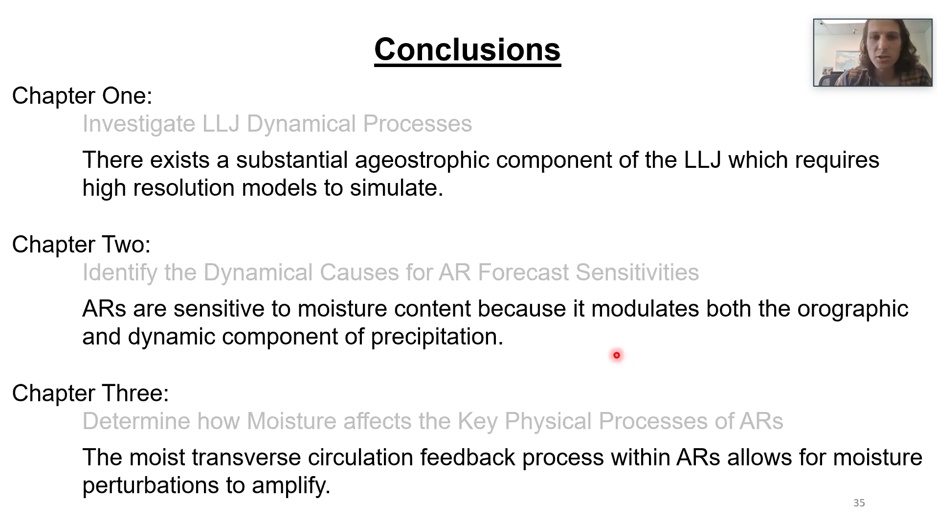
Dr. Voss’s conclusions for her dissertation. Her results help advance our physically-based understanding of the impact of dust on ARs.

Voss, K.K., and A.T. Evan, 2020: A new satellite-based global climatology of dust aerosol optical depth. J. Appl. Meteor. Climatol., 59, 83-102, https://doi.org/10.1175/JAMC-D-19-0194.1.

Voss, K. K., A.T. Evan, Prather, K.A., and F. Martin Ralph, 2020: Dusty Atmospheric Rivers: Characteristics and Origins. J. Clim., in press.

CW3E Welcomes Kerstin Paulsson

CW3E Welcomes Kerstin Paulsson

May 6, 2020

Kerstin Paulsson joined CW3E as a Field Researcher in February 2020. She earned her B.S. in Oceanography from University of Washington, Seattle (2012) and her M.S. in Physical Oceanography from University of Southampton, U.K. (2014), completing her thesis on the modulation of energy dissipation in small-scale turbulent mixing in the Southern Ocean. In 2015, Kerstin joined Scripps as part of the High Resolution eXendable BathyThermograph (HR-XBT) program, and later as part of the Coastal Observing Research and Development Center (CORDC), leading operations of the Miniature Wave Buoy Program. Her work at CORDC involved hands-on instrument building and design, and spectral analysis of surface wave data from Mini Wave Buoys drifting across all ocean basins.

As part of the field research team at CW3E, Kerstin will support observational efforts in Forecast Informed Reservoir Operations (FIRO) and the AR Program. She looks forward to bringing her observational and ocean-based experience to CW3E research efforts and expanding from her physical oceanographic background into the study of snow hydrology, meteorology, and climate on the West Coast.

CW3E Publication Notice: Recent Changes in United States Extreme 3-Day Precipitation Using the R-CAT Scale

CW3E Publication Notice

Recent Changes in United States Extreme 3-Day Precipitation Using the R-CAT Scale

May 6, 2020

CW3E recent PhD graduate Maryam Lamjiri, along with co-authors CW3E Director F. Martin Ralph and longtime CW3E collaborator Mike Dettinger (newly minted CW3E “visiting researcher”), published a paper in the Journal of Hydrometeorology titled “Recent Changes in United States Extreme 3-Day Precipitation Using the R-CAT Scale” (Lamjiri et al. 2020). This work is a part of CW3E’s ongoing effort to understand and improve the predictions of extreme precipitation and support emergency preparedness and resource management in the western United States. This effort includes monitoring and projections of climate variability and change, and the new study in particular strives to provide new insights from weather and climate observations to understand changes in the most extreme events, changes that may already be happening in the US.

Extraordinary precipitation events have impacted the United States (U.S.) in the past several years, with 3-day precipitation totals larger than any others reported in the U.S. during the past 70 years. The R-CAT scaling method is used to document extreme precipitation events and test for trends nationally. The R-CAT scale uses thresholds of 3-day precipitation totals in 100 mm increments (starting with 200 mm) that do not vary temporally or geographically, allowing for simple, intuitive, comparisons of extremes over space and time. The paper that introduced the scale (Ralph and Dettinger 2012) only required levels 1-4 to represent historical extremes, finding that R-CATs 3-4 strike the conterminous U.S. about as frequently as EF 4-5 tornadoes or Category 3-5 hurricanes. Remarkably, two recent hurricanes, Florence (2018) and Harvey (2017), require extending the scale to R-CAT 7 and 9, respectively (Table 1), and the largest 3-day total (Tropical Storm Imelda) in 2019 ranked as an R-CAT 6. This recent unprecedentedly unbroken string of new R-CAT levels prompted a new look at the scale, resulting in the new paper. The most extreme R-CAT event recorded on the west coast since 1950 reached level 5.

Trend analyses of annual maximum 3-day totals (1950-2019) identify significant increases in eastern U.S., along with overall declines in northern California and Oregon. Consistent with these results, R-CAT storms have been more frequent in the eastern and less frequent in the western U.S. during the past decade compared to 1950-2008. Tropical storms dominate R-CAT events along the southeast and east coasts with surprising contributions from atmospheric rivers (in up to 48% of the R-CAT-level events). Much less surprisingly, ARs completely dominate (more than 90%) along the west coast (Fig. 1). The new study, which is based solely on observations, could not demonstrate a statistically-significant shift in the distribution of R-CAT level storms in the past decade. However, a single decade is too small a sample to demonstrate irreversible changes. Nonetheless, the severity of the most recent storms may still turn out to be the first indication that ultra-extreme storms of the “future” are already here.

Table 1. Definition of R-CAT events and modifications to the original R-CAT scale.

Figure 1. (Fig. 6 from Lamjiri et al., 2020): (a) Center location of the R-CAT episodes, 1950-2015, colored based on their R-CAT levels with blue polygons showing coastal regions used in panels b-d. (b), (c), and (d) show number of R-CAT 1 and stronger, R-CAT 2 and stronger, and R-CAT 3 and stronger episodes, respectively, in each coastal region associated with pure-ARs (solid green and red bars), mixed ARs ( ARs mixed with hurricanes and tropical storms, hatched green and red bars), and non-ARs (tropical storms, tropical depressions, and subtropical storms (TS-TD-STS), hurricanes, and other processes, shown by blue, orange, and gray bars, respectively).

Lamjiri, M.A., F.M. Ralph, and M.D. Dettinger, 2020: Recent Changes in United States Extreme 3-Day Precipitation Using the R-CAT Scale. J. Hydrometeor, 0, https://doi.org/10.1175/JHM-D-19-0171.1