CW3E Precipitation Update: 8 March 2021 Outlook

CW3E Precipitation Update: 8 March 2021 Outlook

March 8, 2021

Click here for a pdf of this information.

Cutoff low forecasted to bring precipitation to most of California this week

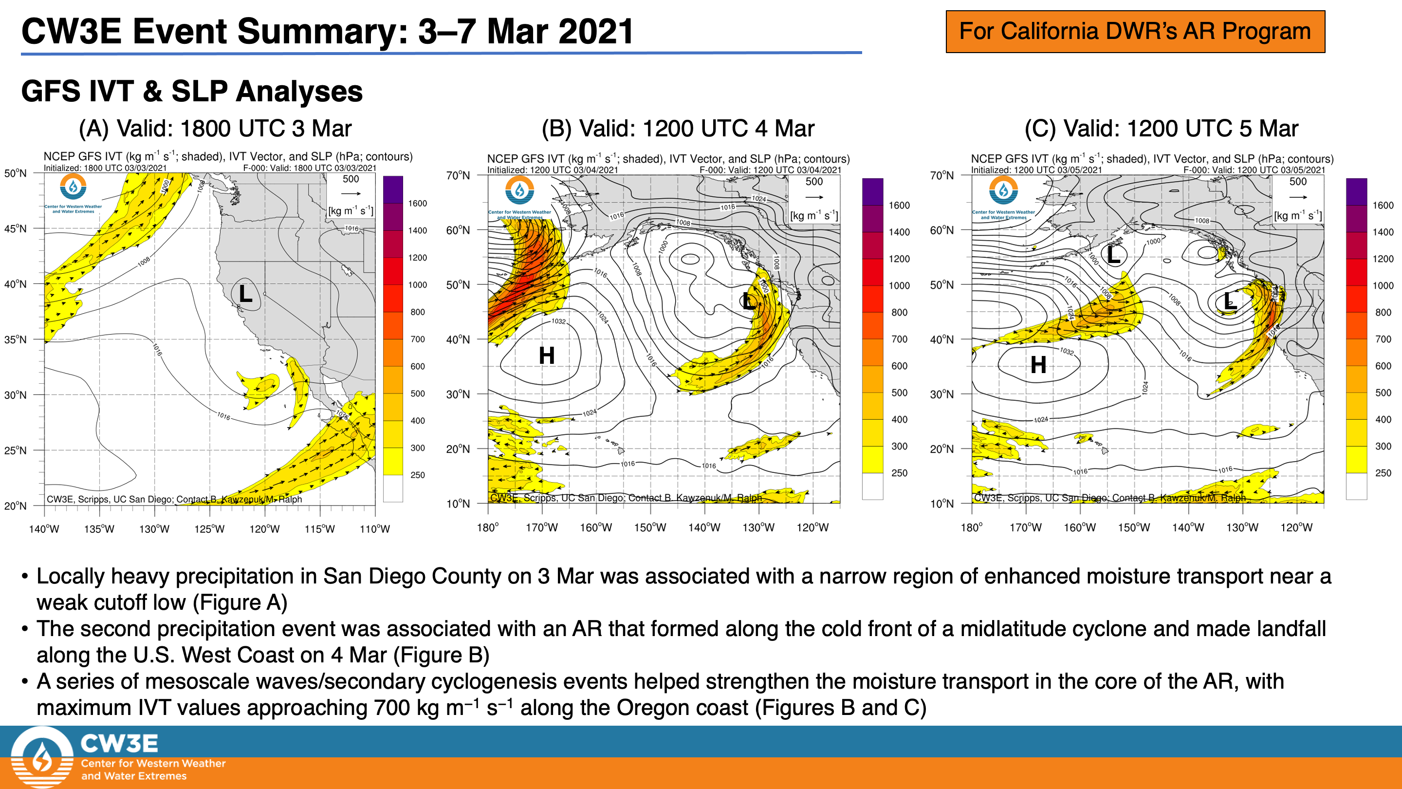
  • Two separate systems impacted Southern California and Northern California last week
  • A cutoff low produced locally heavy rain in San Diego County on 3 Mar
  • A slow-moving AR and associated midlatitude cyclone produced 3–5 inches of precipitation in portions of the Pacific Coast Ranges during 4–7 Mar
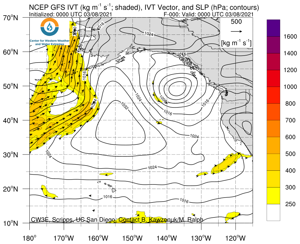
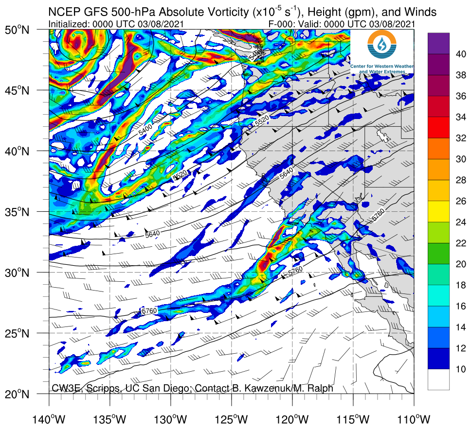
  • A mid-tropospheric trough and low pressure system will make landfall over CA mid week
  • This system is forecast to produce precipitation throughout nearly all of California
  • Precipitation amounts are forecast to be ~1–2 inches over the Northern Sierra Nevada and Transverse ranges with up to 3 inches in San Diego and Shasta Counties
  • While precipitation amounts are not forecasted to be extremely high with this event, the precipitation could help improve drought conditions throughout the state

Click images to see loops of GFS IVT & 500-hPa absolute vorticity forecasts

Valid 1200 UTC 8 March – 1200 UTC 13 March 2021


Summary provided by C. Castellano, J. Kalansky, B. Kawzenuk, and F. M. Ralph; 8 March 2021

*Outlook products are considered experimental

CW3E Publication Notice: The Influence of Antecedent Atmospheric River Conditions on Extratropical Cyclogenesis

CW3E Publication Notice

The Influence of Antecedent Atmospheric River Conditions on Extratropical Cyclogenesis

March 2, 2021

CW3E researcher Zhenhai Zhang and CW3E director F. Martin Ralph published a paper in Monthly Weather Review, titled “The Influence of Antecedent Atmospheric River Conditions on Extratropical Cyclogenesis” (Zhang and Ralph, 2021). As part of CW3E’s 2019-2024 Strategic Plan to support Atmospheric River (AR) Research and Applications, CW3E aims to further the understanding of AR dynamics. This study contributes to the understanding of the relationship between AR and extratropical cyclones (ETC). Specifically, this study quantifies the impacts of an antecedent AR on ETC deepening during the cyclogenesis stage and explores the relevant dynamical and physical processes, especially the role of water vapor inflow from an antecedent AR into a developing ETC.

ARs are recognized as the primary region of strong horizontal water vapor transport typically associated with a low-level jet stream ahead of the ETC cold front. The impacts of ETCs on ARs are widely acknowledged. However, some ETCs begin their development near a pre-existing AR. This study investigates the differences in the cyclogenesis stage between these cyclogenesis events and those that begin without an AR nearby. Well-established ETC and AR detection methods are applied to reanalysis over the North Pacific during the 1979-2009 cool seasons (November-March). Of the 3137 cyclogenesis cases detected, 35% are associated with a nearby AR at the time of initial cyclogenesis. However, in the 448 cyclones that deepen explosively after their initiation, 60% begin with a pre-existing AR nearby. On average, an ETC with an antecedent AR nearby deepens more quickly during the cyclogenesis stage than those without a pre-existing AR.

The roles of both dry and diabatic processes that contribute to cyclogenesis are examined, including low-level baroclinicity, upper-level forcing, water vapor inflow, and latent heating. The results are summarized in a schematic that uses the composite fields from 3137 cyclogenesis cases to compare the cyclogenesis with and without an antecedent AR (Figure 1). ETCs that develop associated with a pre-existing AR receive nearly 80% more water vapor inflow on average, enhancing latent heating and intensifying ETC deepening significantly in the cyclogenesis stage. In contrast, neither low-level baroclinicity nor upper-level potential vorticity exhibit statistically significant differences between cyclogenesis events with and without an antecedent AR. These results imply that when the dry dynamical factors (low-level baroclinicity and upper-level forcing) initialize cyclogenesis, a nearby antecedent AR can provide extra fuel (water vapor inflow) to enhance the diabatic process significantly and intensify ETC deepening during the cyclogenesis stage. Cyclogenesis events associated with an exceptionally strong AR at the ETC initial time deepen even more rapidly, indicating that the intensity of an antecedent AR can modulate the ETC deepening in the cyclogenesis stage.

This study improves the understanding of extratropical cyclogenesis, including rapid cyclogenesis, which elucidates the vital role of antecedent horizontal water vapor transport, as delineated by the existence and intensity of an antecedent AR. These results imply that errors in initial conditions related to ARs can contribute to errors in both AR and ETC predictions. It reinforces the importance of ensuring global weather prediction models are initialized with accurate representations of ARs in their initial conditions, including the unique AR-targeted observations provided by AR Reconnaissance (Ralph et al. 2020).

Figure 1: Fig. 15 from Zhang and Ralph (2021). Schematic summary of the cyclogenesis not associated with an antecedent AR (a, c) and associated with an antecedent AR (b, d) at the time of cyclogenesis (a, b) and 24h after cyclogenesis (c, d). The structures and magnitudes of IVT (gray contour, yellow, orange and red), upper-level PV (300-200 hPa, light blues), upper-level jet (300 hPa, dash and solid blue contours), and SLP (every 2 hPa, black contours) are based on the corresponding composite fields of cyclogenesis cases over the North Pacific in 31 (1979-2009) cool seasons from CFSR. In (a) and (b), the red circle denotes the position of maximum IVT, and the black dot denotes the position of incipient low-pressure center at the time of cyclogenesis. In (c) and (d), the closed SLP contours start from the first closed SLP at the time of cyclogenesis not associated with an antecedent AR (1010 hPa) and associated with an antecedent AR (1006 hPa) respectively.

Zhang, Z., & Ralph, F. M. (2021). The Influence of Antecedent Atmospheric River Conditions on Extratropical Cyclogenesis, Monthly Weather Review, https://doi.org/10.1175/MWR-D-20-0212.1.
CW3E Event Summary: 21-23 February 2021

CW3E Event Summary: 21-23 February 2021

February 24, 2021

Click here for a pdf of this information.

Atmospheric River Brings Rain and Snow to Portions of the Northwestern U.S.

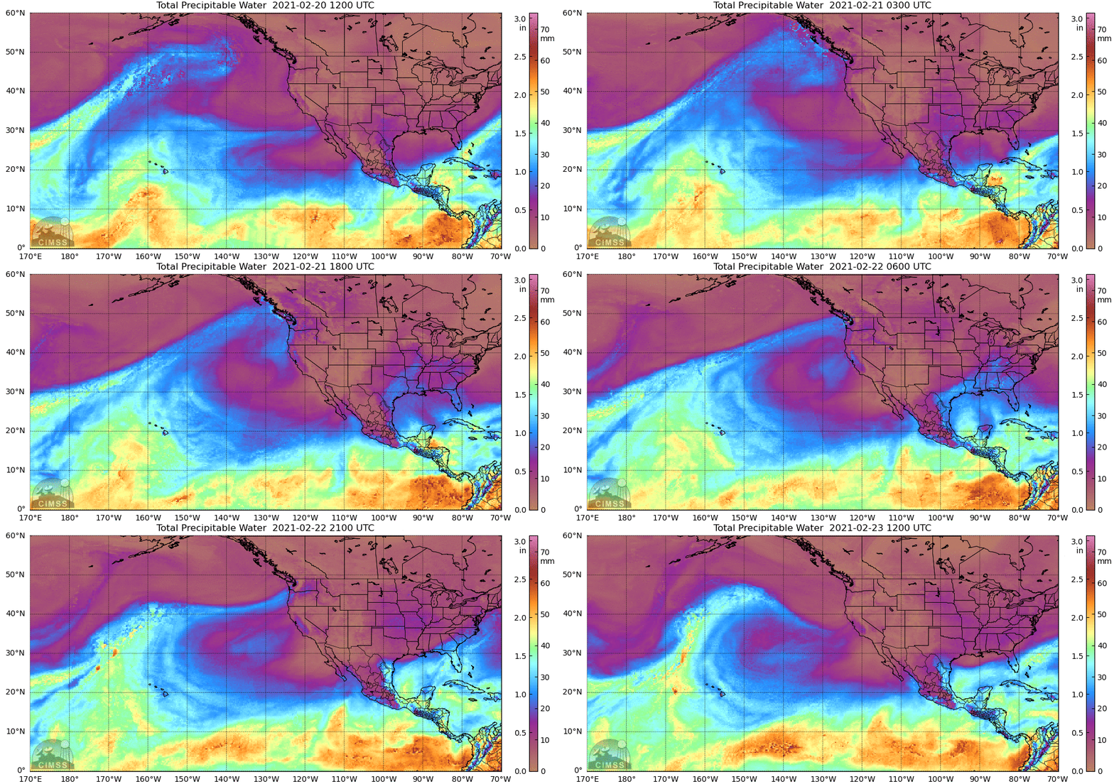
  • The AR made landfall during the early morning of 21 February over Washington and northern Oregon
  • Coastal locations in Washington and northwestern Oregon experienced AR 2 conditions (based on the Ralph et al. 2019 AR Scale)
  • More than 5 inches of precipitation fell in parts of the Olympic Peninsula and North Cascades
  • More than 2 feet of snow fell in the higher elevations of the Washington Cascades and Bitterroot Mountains
  • The combination of near-saturated soil conditions, heavy rain, and melting snow produced minor flooding in western Washington
  • Several avalanches were also reported near Stevens Pass (in addition to the planned avalanche control work)

MIMIC-TPW2 Total Precipitable Water

Valid 1200 UTC 20 February – 1200 UTC 23 February

Images from CIMSS/University of Wisconsin

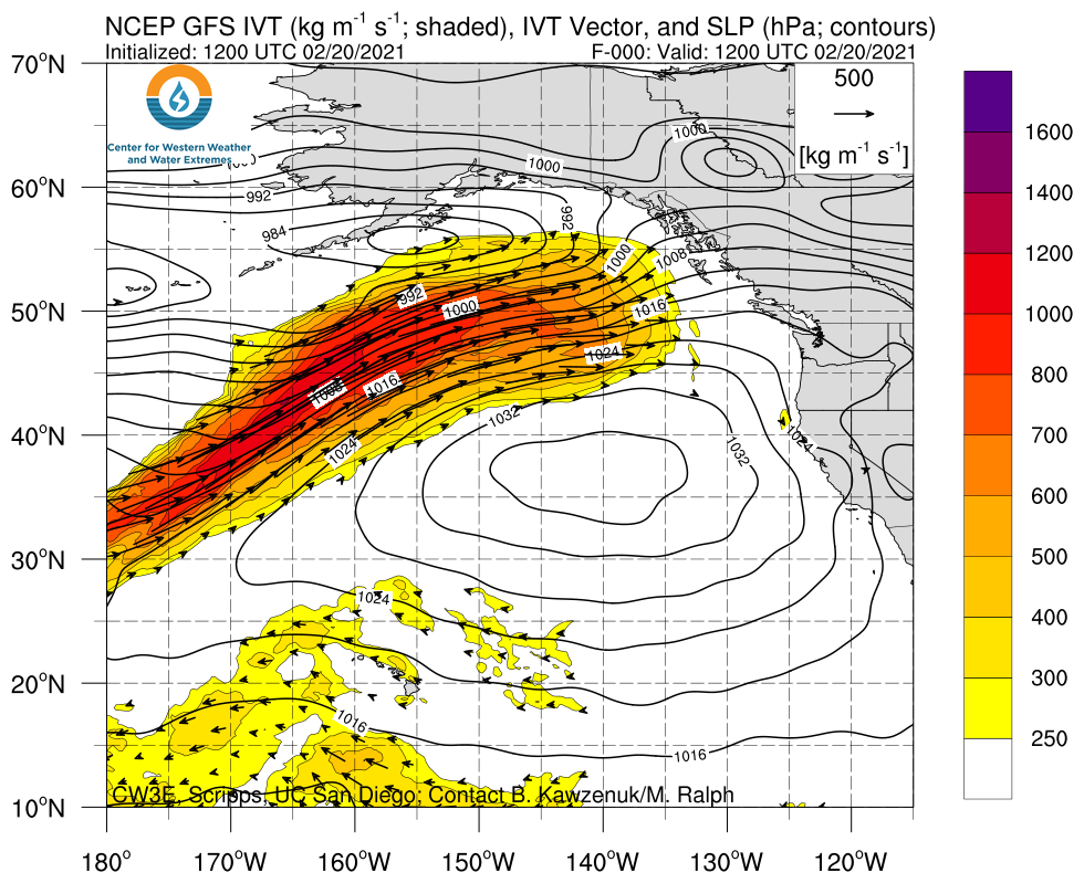
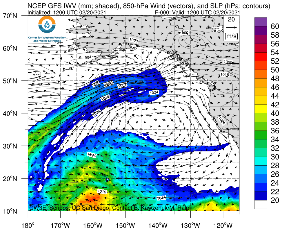
Click images to see loops of GFS IVT/IWV analyses

Valid 1200 UTC 20 February – 1200 UTC 23 February


Summary provided by C. Castellano, J. Kalansky, N. Oakley, and F. M. Ralph; 24 February 2021

CW3E AR Update: 19 February 2021 Outlook

CW3E AR Update: 19 February 2021 Outlook

February 19, 2021

Click here for a pdf of this information.

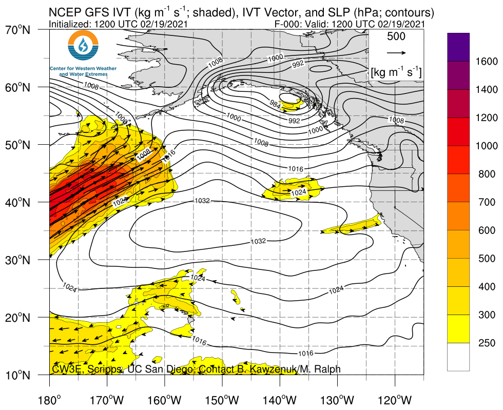
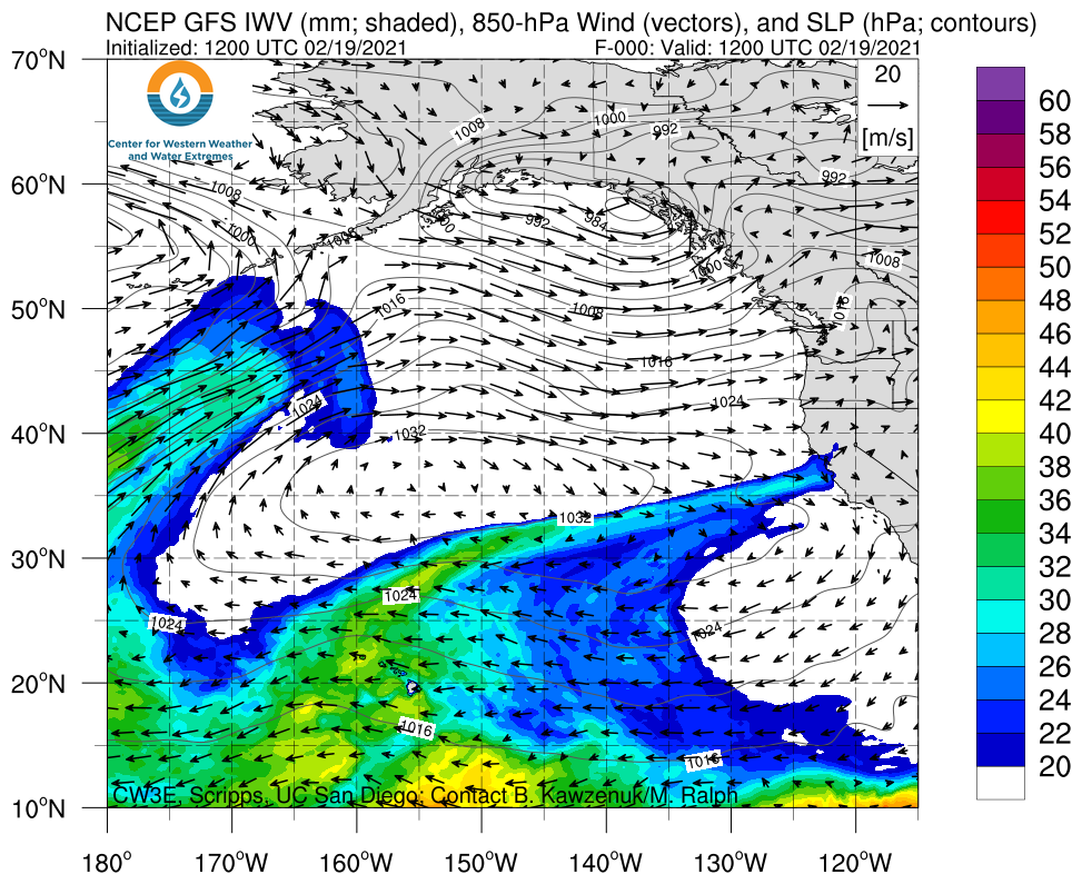
Landfalling AR to impact the Pacific Northwest this weekend into early next week

  • An AR is forecast to make landfall across Washington and northern Oregon early Sunday morning
  • AR 2 conditions (based on the Ralph et al. 2019 AR Scale) are possible in coastal Washington and northern coastal Oregon
  • More than 5 inches of total precipitation (locally > 7 inches) are forecast in the Olympic Mountains and North Cascades during the next 5 days
  • Rising freezing levels in association with this AR will likely result in rain-on-snow in areas that have recently received significant snowfall
  • The combination of near-saturated soil conditions, heavy rain, and melting snow may lead to flooding at lower elevations in western Washington

Click images to see loops of GFS IVT & IWV forecasts

Valid 1200 UTC 19 February – 1200 UTC 23 February 2021


Summary provided by C. Castellano, J. Kalansky, B. Kawzenuk, N. Oakley, and F. M. Ralph; 19 February 2021

*Outlook products are considered experimental

CW3E Middle School Meteorology at EarthLab STEAM Camp

CW3E Middle School Meteorology at EarthLab STEAM Camp

February 15, 2021

On Monday February 15, CW3E field team members Douglas Alden and Kerstin Paulsson (pictured, Fig. 1) participated in the EarthLab STEAM Camp through the UCSD-EarthLab Community Station, a partnership between Groundwork San Diego-Chollas Creek and the UCSD Center on Global Justice. The community stations are field research sites located in underserved neighborhoods in the San Diego-Tijuana region where UCSD researchers and community members collaborate for teaching and research. For more information, go to the UCSD Community Stations website here!

In the STEAM Camp outdoor classroom, kids from nearby Millennial Tech and Knox Middle Schools learned about our field team members’ paths into science careers and the ins and outs of CW3E fieldwork. The kids got a great refresher of the water cycle and learned about how the data collected at weather stations, such as those installed by CW3E, help to forecast extreme events and watershed runoff, as well as how that data is used to maintain the reservoirs that feed their kitchen tap!

The team brought surface meteorological instruments for show and tell to provide some hands on learning. This included an anemometer, tipping bucket, disdrometer, dropsonde, weather balloon, and soil moisture and temperature sensors.

In consonance with CW3E core values of collaboration, education, and diversity, outlined in CW3E’s 2019-2024 Strategic Plan, the EarthLab centers environmental education in economic, energy, and health equity. This was the first collaboration between CW3E and the UCSD-EarthLab Community Station, and we are excited to continue our partnership in years to come! As research has shown, this community-university engagement cultivates youth leadership, community capacity, and ultimately produces better, more sustainable outcomes for both the university and community partners.

Visit Groundwork San Diego’s EarthLab webpage here for more information on the STEAM camp and the work they do with the community around the Chollas Creek Watershed.

Kids from Millennial Tech Middle School learn about hydrology and CW3E fieldwork from field team members Douglas Alden (standing, center) and Kerstin Paulsson (standing, left).

An assortment of meteorological instruments were provided for demonstration and hands-on learning.

CW3E Welcomes Ming Pan

CW3E Welcomes Min Pan

January 25, 2021

Dr. Ming Pan joined CW3E as a senior research hydrologist on February 1, 2021. He received his B.E in Hydraulic Engineering (major) and Computer Science (minor) in 2000 from Tsinghua University Beijing, China, and his Ph.D. degree in Hydrology and Water Resources in 2006 from Princeton University, NJ, USA.

Prior to joining CW3E, Ming served as a postdoctoral researcher at Massachusetts Institute of Technology (2006-2007), an associate research scientist at Princeton University (2008-2014), and a research faculty at Princeton University (2014-2021). He has been working in the general area of land surface hydrology since his PhD time and his research focuses on quantifying various states/fluxes of the terrestrial water cycle at different scales from local to global, and developing the data and tools for solving related application problems, for example, land surface hydrologic modeling, hydrologic remote sensing, and hydrologic systems (both natural and human built/managed) under a changing climate (e.g., water availability & sustainability, flood, and drought). He has extensive research experience in physically based hydrologic modeling (e.g. land surface models, river hydrodynamic models, human water use/water management), remote sensing of surface hydrologic parameters and their applications, and in hyper-resolution land surface modeling (field scale of <100 m).

At CW3E, Ming will be working with the hydrology group to grow the capacity and impact of CW3E’s research and operations in hydrology and water resources engineering, based upon CW3E’s long-standing excellences in areas like Atmospheric Rivers (AR) studies, AR-Recon, short-term weather and seasonal scale climate forecasting, reservoir operations, observation networks, and various process studies (flood, snow, soil moisture, wild fire, etc.).

CW3E AR Update: 12 February 2021 Outlook

CW3E AR Update: 12 February 2021 Outlook

February 12, 2021

Click here for a pdf of this information.

Multiple ARs forecast to impact the Western U.S. this weekend into early next week

  • A weak AR brought light-to-moderate precipitation to Northern and Central California yesterday
  • A second AR and associated surface cyclone will approach the U.S. West Coast today, bringing hazardous winter weather to lower elevations in western Washington and northwestern Oregon
  • A third and stronger AR is forecast to make landfall across California and Oregon on Sunday
  • The third AR is forecast to bring AR 2/AR 3 conditions to portions of coastal California and Oregon, but the heaviest precipitation is expected to remain far north of the AR 3 area in California due to the unfavorable orientation of the IVT vectors (parallel to the coast)
  • More than 5 inches of total precipitation are possible in portions of the Pacific Coast Ranges and Cascades during the next 5 days, with the highest amounts forecast in the Oregon Cascades

Click images to see loops of GFS IVT & IWV forecasts

Valid 0600 UTC 12 February – 0600 UTC 17 February 2021


Summary provided by C. Castellano, C. Hecht, J. Kalansky, N. Oakley, and F. M. Ralph; 12 February 2021

*Outlook products are considered experimental

Distribution of Landfalling Atmospheric Rivers over the U.S. West Coast During Water Year 2021: Quarter Year Summary

Distribution of Landfalling Atmospheric Rivers over the U.S. West Coast During Water Year 2021: Quarter Year Summary

February 11, 2021

For a pdf of this information click here.


Link to a post-event summary of the 26 to 29 January 2021 AR here
 

Analysis by Chad Hecht, Jason Cordeira, Julie Kalansky, & F. Martin Ralph. This analysis is considered experimental. For questions regarding the data or methodology please contact Chad Hecht

Estimating Benefits of Forecast-Informed Reservoir Operations (FIRO): Lake Mendocino Case-Study and Transferable Decision Support Tool

Estimating Benefits of Forecast-Informed Reservoir Operations (FIRO): Lake Mendocino Case-Study and Transferable Decision Support Tool

February 11, 2021

Tom Corringham (CW3E) helped develop economic methodologies for assessing benefits of FIRO for a study sponsored by the US Bureau of Reclamation and Sonoma Water. The study was led by economists Dr. Lou Nadeau and Tess Hubbard at Eastern Research Group (ERG), who estimated Lake Mendocino FIRO benefits at over $9Million annually. Caitline Barber (ERG) developed a Decision Support Tool to apply methods to other reservoirs, and the DST was used to test transferability at Prosser Reservoir in the Truckee River Watershed. For more information, see AGU interactive poster here and the Lake Mendocino FVA Section 5.

A New CW3E Fieldwork Season Begins

A New CW3E Fieldwork Season Begins

February 10, 2021

The Center for Western Weather and Water Extremes (CW3E) 2021 fieldwork season is off to a busy start with a series of atmospheric river events that arrived in January. Due to COVID-19, this year’s field season looks a little different than in seasons past. Rather than rotating crews from week-to-week, two dedicated teams headed to Northern California for the full duration of the wet season to sample impactful atmospheric river events.

One team is launching radiosondes from the UC Davis Bodega Marine Laboratory in Bodega Bay, CA (coastal site), while the other is launching from a Yuba Water Agency warehouse in Marysville in Yuba County (Sierra foothills site). The teams have been following all county, state and federal recommended health and safety protocols to minimize COVID risk in the field amidst the ongoing pandemic. Teams have also coordinated with partner organizations including Yuba Water Agency and vetted all fieldwork plans through UCSD’s Research Ramp Up process to ensure we are following the most conservative protocols and staying safe.

One of the first atmospheric river events recorded this season was a moderate event from 26-29 January, with a peak integrated water vapor transport (IVT) of 604.3 kg m-1 s-1 and integrated water vapor (IWV) of 21.06 mm at Bodega Bay at 0556Z 27 January 2021 (Figure 1). The highest precipitation accumulations occurred at the Boyes Creek Canyon location in the Lake Mendocino watershed, which recorded over 2 inches of precipitation between 26 January and 29 January.

In between storm events, the remote field teams hope to install a new soil meteorological (SMOIL) station in the Yuba River Watershed and Micro Rain Radar stand-alone stations in South Lake Tahoe and Truckee, CA. They also plan to conduct maintenance on existing sites in the Russian River watershed.

The CW3E plans to continue releasing radiosondes, and if possible, collecting manual streamflow measurements and isotope samples during atmospheric river events throughout this winter season. The radiosonde data are shared with the National Weather Service WFOs throughout Western Region, as well as transmitted to the Global Telecommunications System for ingest into global numerical weather prediction models. This campaign supports current efforts to understand and improve forecasts of ARs in the Russian River and Yuba/Feather Watersheds, as a part of Forecast-Informed Reservoir Operations (FIRO). For an overview of our collaboration with Yuba Water Agency for data collection for FIRO, head over to their website and read their recent news post here!

A radiosonde launch completed at Bodega Bay (0556Z 27 January 2021) showing the peak IVT recorded at BOD during this AR: 604.3 kg m-1 s-1.

Chad Hecht (Meteorology Staff Researcher) releases a radiosonde from Marysville, CA, on 26 January.

Ava Cooper (Field Researcher) fills a balloon in preparation for a radiosonde launch from UC Davis’s Bodega Bay Marine Lab in Bodega Bay, CA, on 26 January.