CW3E Publication Notice
Atmospheric Rivers in Southeast Alaska: Meteorological Conditions Associated With Extreme Precipitation
February 29, 2024
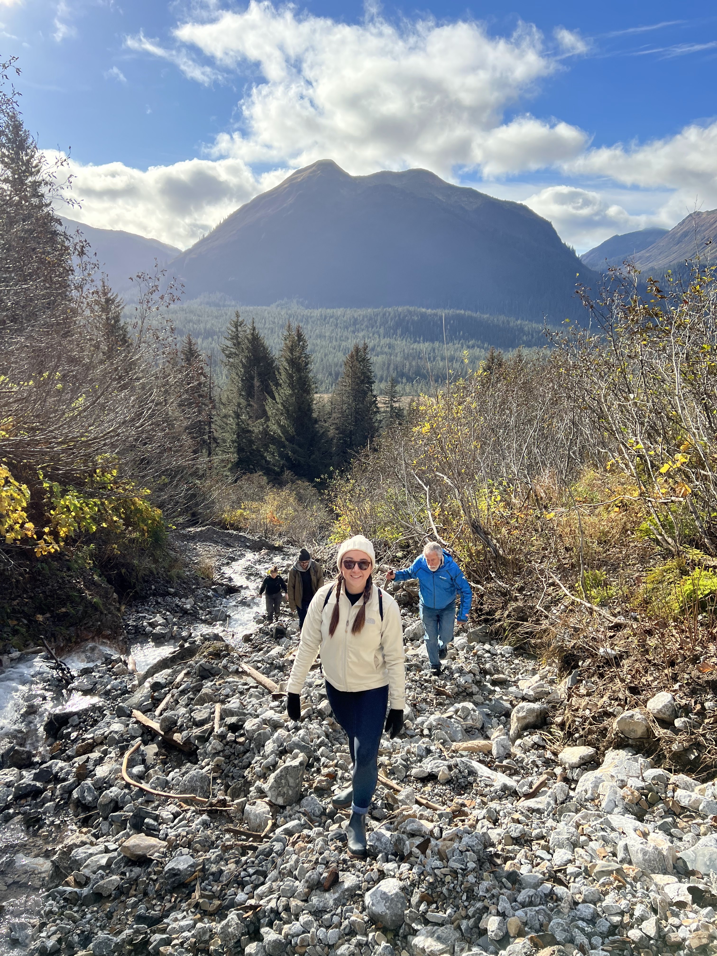
Figure 1. The Vortex Landslide near Hoonah, AK which occurred during the devastating December 2020 AR and continues to block roads to important hunting areas highlights the impacts of extreme precipitation events associated with ARs in Southeast Alaska, threatening the stability and safety of indigenous and rural Alaska communities. Credit: Deanna Nash, October 2022
A new paper titled, “Atmospheric Rivers in Southeast Alaska: Meteorological Conditions Associated With Extreme Precipitation” by Deanna Nash (CW3E), Jon Rutz (CW3E), and Aaron Jacobs (NWS Juneau) was recently published in Journal of Geophysical Research – Atmospheres. The research was supported by National Science Foundation’s Coastlines and Peoples Program (award 2052972) and presents a climatology (1980–2019) of atmospheric rivers (ARs) and heavy precipitation, as well as other relevant synoptic, mesoscale, and local meteorological characteristics for six rural and indigenous communities in Southeast Alaska.
This work is associated with two of five major priorities outlined in CW3E’s Strategic Plan: “Atmospheric Rivers Research and Applications” and “Monitoring and Projections of Climate Variability and Change”. These priorities are addressed by furthering our understanding of AR-related extreme precipitation events that trigger floods, landslides, and avalanche events across Southeast Alaska, establishing a historical baseline for comparison against future climate change scenarios, and developing operationally useful forecast tools in collaboration with the National Weather Service (NWS) in Juneau, Alaska. This study also highlights deep collaboration with local community partners to address the increased risk of impacts related to extreme weather disproportionately impacting coastal, rural and Indigenous communities. In developing this work, Deanna spent over a month in Southeast Alaska, learning about community priorities for extreme precipitation events, co-producing the research with NWS Juneau, and engaging with the community through education on AR events associated with extreme precipitation.
Results show that from 1980 to 2019, ARs occur on ∼120 days per year in Southeast Alaska, but ∼6 days produce 68%–91% of precipitation >95th percentile. The AR conditions are canonical – high-amplitude upper-level patterns across the northeastern Pacific Ocean favor southwesterly ARs reaching Southeast Alaska (Figure 2a), where moisture is orographically lifted, resulting in heavy precipitation, particularly on southwest facing slopes (Figure 3a). However, across the complex, post-glacial terrain of this region, variations in mesoscale and meteorological conditions can mean extreme precipitation for one region, but not another. For example, extreme precipitation days at Klukwan are most favored with a more cyclonic orientation of the anomalous IVT pattern associated with ARs, allowing moisture to flow up the inland channels (Figure 2b).
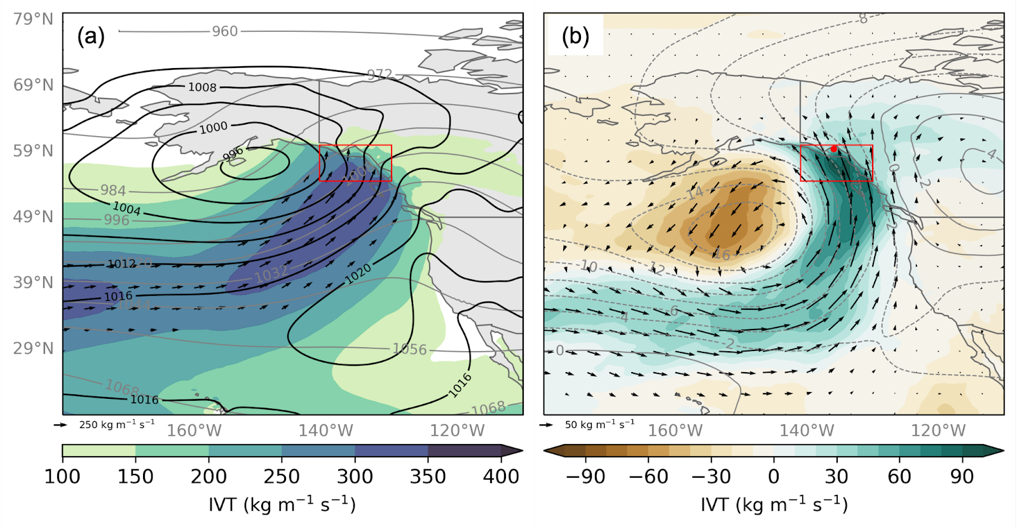
Figure 2. (a; Fig. 4c) Average daily composites of ERA5 IVT (shaded and vectors; kg m-1 s-1), 250 hPa geopotential height (gray contours; dam), and MSLP (black contours; hPa) for all AR days in the six communities that are >95th percentile precipitation (n=911). (b; Fig. 4g) Composite differences of ERA5 IVT (shaded and vectors; kg m-1 s-1) and 250 hPa geopotential height (contours; dam) for Klukwan during extreme Atmospheric River days and the average for all communities during extreme AR days (e.g., Community AR IVT – Average AR IVT). The red dot indicates the location of Klukwan. IVT vectors are only plotted where IVT and 250 hPa geopotential height values are statistically significant at the 95% confidence interval.
In areas like Klukwan and Skagway, 80%–90% of extreme AR days have south-southwesterly or south-southeasterly IVT (Figure 3b). In areas like Yakutat, although southeasterly IVT is more common, extreme precipitation events are most common with southwesterly IVT. These results are being broadly shared with these communities through non-technical takeaways and future work plans to incorporate general information on potential socio-economic impacts into the NWS warning process to improve their effectiveness.
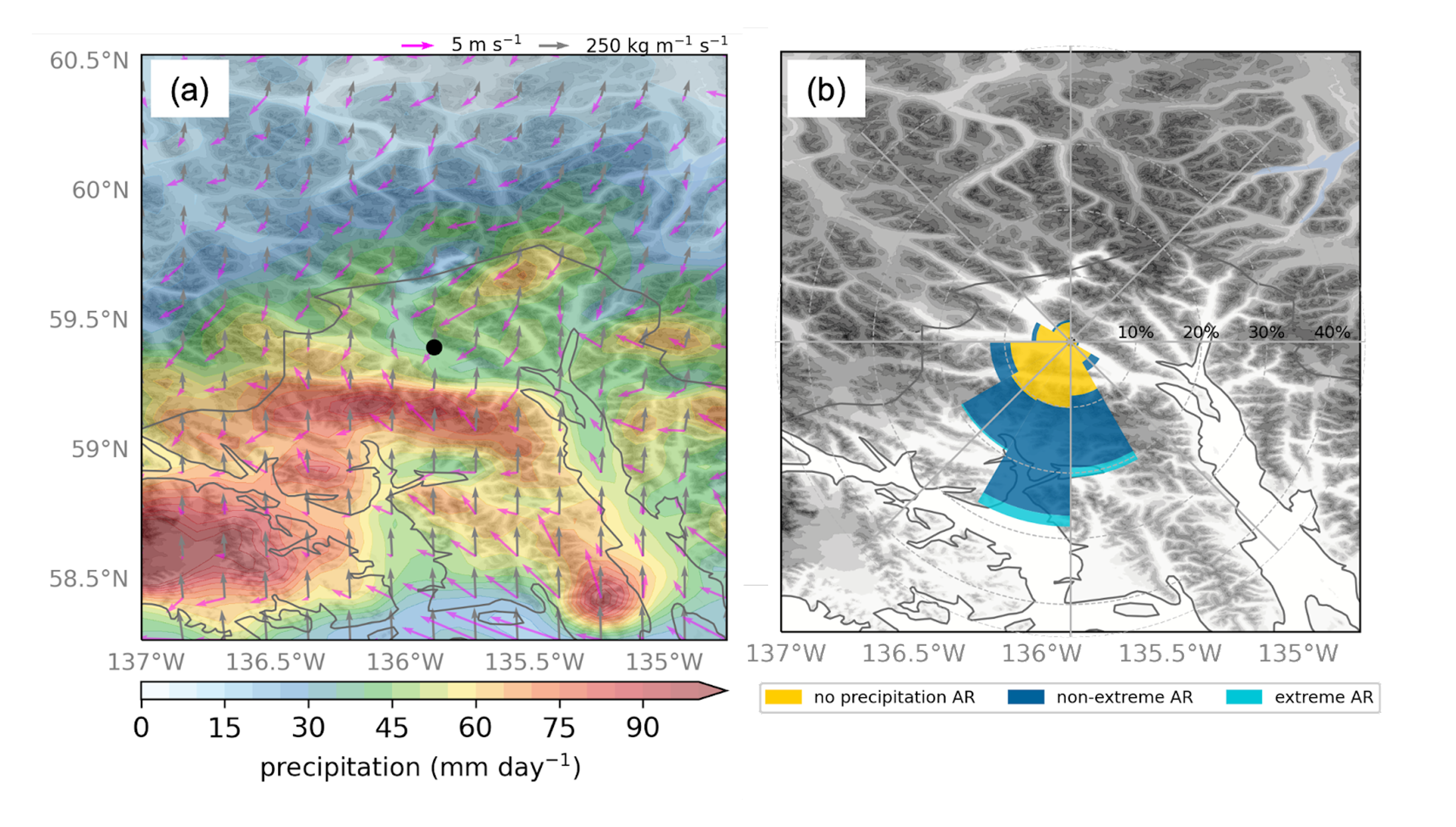
Figure 3. (a; Fig. 6d) Average daily composites of WRF precipitation (shaded; mm day-1), ERA5 IVT (gray vectors, kg m-1 s-1), and WRF 1000 hPa winds (pink vectors, m s-1) for Klukwan during extreme AR days. The location of Klukwan is shown by the black point. (b; Fig. 5d) Topographical map of Hoonah using USGS GMT elevation data (shaded; m) where higher elevations are darker shades. Wind rose diagrams for IVT direction from ERA5 data for all days when an AR was present in Southeast Alaska is overlaid, centered on the grid cell nearest Klukwan. The total length of each bar indicates the frequency (%) of events with IVT in that particular direction. The length of colored areas within the bar indicates the frequency (%) of events with precipitation <2.5 mm day-1 (yellow), <95th percentile precipitation (blue), and >95th percentile precipitation (aqua) that also occurred in that direction.
Nash, D., Rutz, J.J., and Jacobs, A. Atmospheric Rivers in Southeast Alaska: Meteorological Conditions Associated With Extreme Precipitation JGR-Atmospheres (2024).https://doi.org/10.1029/2023JD039294