CW3E AR Update: 15-17 December 2016 Outlook
December 15, 2016
Click here for a pdf of this information.

|
Update on AR Impacting California
 |


Summary provided by C. Hecht, and F.M. Ralph; 1 PM PT Wed 15 Dec. 2016

CW3E AR Update: 15-17 December 2016 Outlook
December 15, 2016
Click here for a pdf of this information.
|
Update on AR Impacting California
|
Summary provided by C. Hecht, and F.M. Ralph; 1 PM PT Wed 15 Dec. 2016
CW3E AR Update: 14-17 December 2016 Outlook
December 14, 2016
Click here for a pdf of this information.

|
Update on AR Impacting California
 |


Summary provided by C. Hecht, and F.M. Ralph; 1 PM PT Wed 14 Dec. 2016
CW3E AR Update: 13-17 December 2016 Outlook
December 13, 2016
Click here for a pdf of this information.
|
Landfalling AR to impact California
Click IVT or IWV image to see loop of 0-90 hour GFS forecast (Valid 1200 UTC 13 Dec – 0600 17 Dec)  |


Summary provided by C. Hecht, and F.M. Ralph; 12 PM PT Tue 13 Dec. 2016
CW3E Participates in Water in the West: A Science Policy Roundtable
December 10, 2016
CW3E was represented in a December 8, 2016 panel discussion hosted by UCSD’s School of Global Policy and Strategy (GPS)’s Science Policy Fellows Program and SIO’s Science Policy Discussion Group, titled “Water in the West: A Science Policy Roundtable”. The purpose of the event was to bring together our different communities and explore the sources of California’s water supply, how water supply can change, how it is used throughout the state and best practices for optimal regulation of its use.
CW3E director Dr. F. Martin Ralph acted as moderator. Other panel members were Dr. Jennifer Burney of GPS, Sandra Kerl of the San Diego County Water Authority, and Dr. Dan Cayan of SIO and a CW3E collaborator. Dr. Scott Sellars, the leader of the Science Policy Discussion Group, was involved in organizing the event. Other CW3E postdocs and graduate students assisted with logistics. The attendance was just over 100 people, with a very engaged audience. Questions were asked on topics ranging from specific projects run by the SD County Water Authority, to potential changes to academic funding sources with the incoming federal administration, to questions on groundwater and atmospheric rivers science. The event was recorded and can be viewed here.
More details are available in the GPS news story.
CW3E AR Update: 9-13 December 2016 Outlook
December 9, 2016
Click here for a pdf of this information.
|
Landfalling AR to impact California
|

GFS forecast from 06 UTC 9 Dec – 00 UTC 13 Dec 2016, showing IVT (shading and vectors) and sea level pressure |

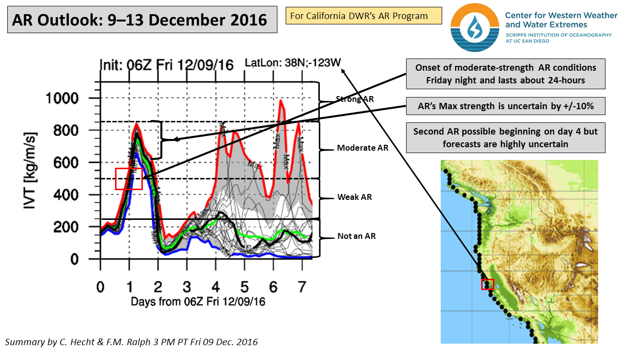


Summary provided by C. Hecht, and F.M. Ralph; 3 PM PT Fri 09 Dec. 2016
Odds of Reaching 100% of Normal Precipitation for Water Year 2017 (December Update)
December 9, 2016
Contribution from Dr. M.D. Dettinger, USGS
The odds shown here are the odds of precipitation in the rest of the water year (after November 2016) totaling a large enough amount to bring the water-year total to equal or exceed the percentage of normal listed. “All Yrs” odds based on monthly divisional precipitation totals from water year 1896-2015. Numbers in parenthesis are the corresponding odds if precipitation through October had been precisely normal (1981-2010 baseline).
Click here for a pdf file of this information.


How these probabilities were estimated:
At the end of a given month, if we know how much precipitation has fallen to date (in the water year), the amount of precipitation that will be required to close out the water year (on Sept 30) with a water-year total equal to the long-term normal is just that normal amount minus the amount received to date. Thus the odds of reaching normal by the end of the water year are just the odds of precipitation during the remaining of the year equaling or exceeding that remaining amount.
To arrive at the probabilities shown, the precipitation totals for the remaining months of the water year were tabulated in the long-term historical record and the number of years in which that precipitation total equaled or exceeded the amount still needed to reach normal were counted. The fraction of years that at least reached that threshold is the probability estimate. This simple calculation was performed for a full range of possible starting months (from November thru September) and for a wide range of initial (year-to-date) precipitation conditions. The calculation was also made for the probabilities of reaching 75% of normal by end of water year, 125%, and 150%, to ensure that the resulting tables of probabilities cover almost the full range of situations that will come up in the future.
[One key simplifying assumption goes into estimating the probabilities this way: The assumption that the amount of precipitation that will fall in the remainder of a water year does not depend on the amount that has already fallen in that water year to date. This assumption was tested for each month of the year by correlating historical year-to-date amounts with the remainder-of-the-year amounts, and the resulting correlations were never statistically significantly different from zero, except possibly when the beginning month is March, for which there is a small positive correlation between Oct-Mar and Apr-Sept precipitation historically.]
Contact: Michael Dettinger (USGS)
CW3E Water Year 2017 Precipitation (December Update)
December 1, 2016
Click here for a pdf file of this information.


Summary provided by C. Hecht and F.M. Ralph
CW3E partners with California Department of Water Resources, California Geological Survey, US Geological Survey, and the Western Regional Climate Center to assess post-fire debris flow hazards in northern California
December 2, 2016
Highlights
Atmospheric River knowledge and tools support post-fire debris flow hazard mitigation and fast-response studies of debris flow-meteorology linkages
An important consequence of the recent record drought in parts of California is the occurrence of major wildfires. The Butte, Valley and Soberanes fires occurred in the last 18 months and have been some of the largest in California history. These tragic burns caused many adverse impacts at the time, and continue to create natural hazards due to the increased risk of damaging debris flows that can occur after the rains return.
California’s burned steeplands are prone to hazardous debris flows during winter storms. Wildfires remove vegetation and alter soil properties, increasing the likelihood of debris flows, even for relatively low intensity storms. When rainfall of sufficient intensity and duration impacts recently burned steeplands, landslides and surface runoff can mobilize ash, rocks, and other material into debris flows that devastate life and property.
California’s Department of Water Resources (DWR) is sponsoring work to examine the role of Atmospheric Rivers on flooding and landslide occurrence and magnitude. The project is led by the Center for Western Weather and Water Extremes (CW3E) at Scripps Institution of Oceanography and includes a team of experts from Scripps, California Geological Survey (CGS) and the U.S. Geological Survey (USGS) Landslide Hazards Team.
Within these burn areas, the geology team, led by Jeremy Lancaster of CGS, is deploying sensors and making measurements in the burn areas when conditions warrant. Doing so requires making decisions on whether to make observations at a study site following a storm event. In support of this, CW3E Graduate Student researchers Nina Oakley and Meredith Fish are using new knowledge of weather systems capable of producing intense precipitation, especially Atmospheric Rivers, to evaluate the potential for high-intensity precipitation over the Soberanes Fire, Butte Fire, and Valley Fire burn areas to advise Lancaster. Key to these preparations and day-to-day decisions are the new Atmospheric River forecasting tools at CW3E. Additionally, post-storm, CW3E scientists will compile meteorological data relevant to the storm event such as maximum precipitation intensity, storm total precipitation, radar imagery, an evaluation of Atmospheric River variables, and any information unique to that storm. For events that produce a debris flow response, a more in-depth case study will be conducted combining both geologic and atmospheric information.
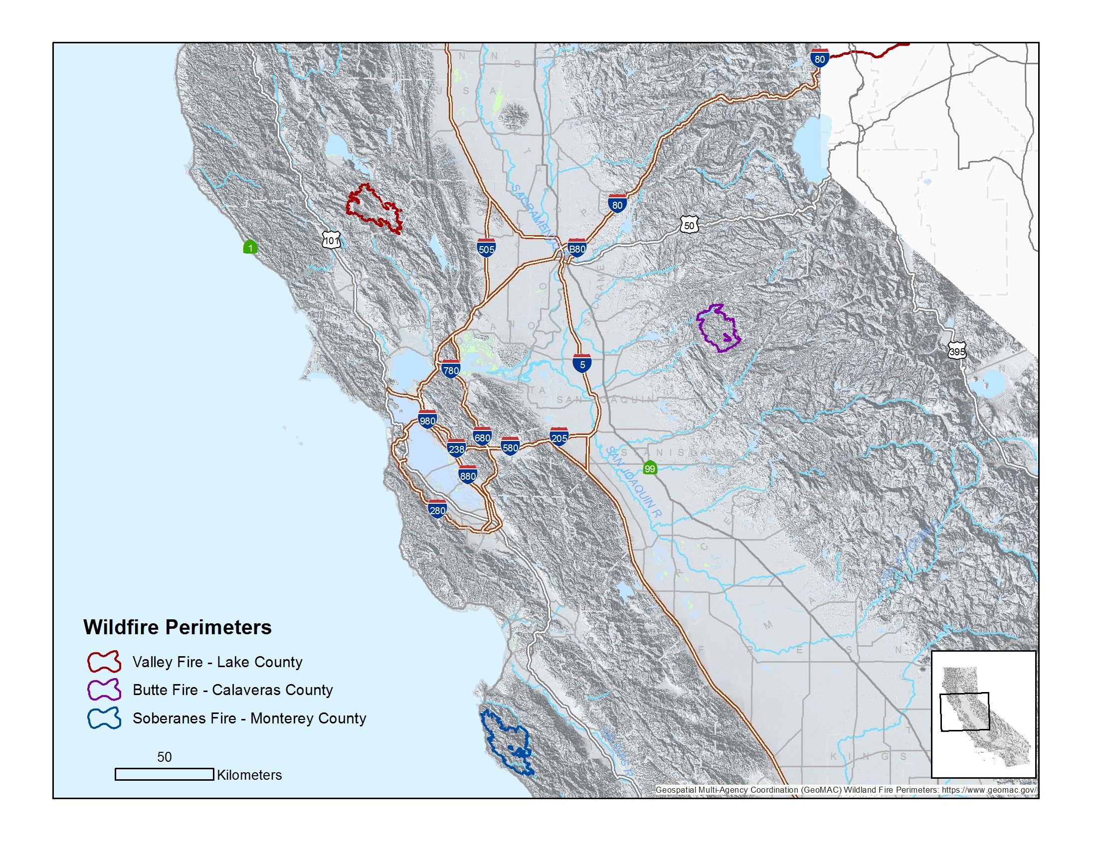
Figure 1: Map of three burn areas that we propose to assess: Soberanes, Valley, and Butte wildfires.
Synthesis of the information collected through these storm and debris flow response logs will provide insight to post-fire debris flow triggering rainfall thresholds across northern California and the meteorological conditions that produce such rainfall. This integrated approach of meteorologists and geologists working together to address the post-fire debris flow issue will help advance our knowledge of these potentially hazardous events. This knowledge will be incorporated into landslide/debris flow hazard outlooks that factor in both landscape conditions (e.g., fire) and meteorology (e.g., extreme precipitation from Atmospheric Rivers)
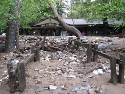
Figure 2: Debris flow deposits stopped by cement barriers outside the Big Sur Lodge in California. This event was triggered by rain falling on burned steeplands in 2009, near an area now burned again by the Soberanes wildfire. (credit: David Longstreth, CGS).
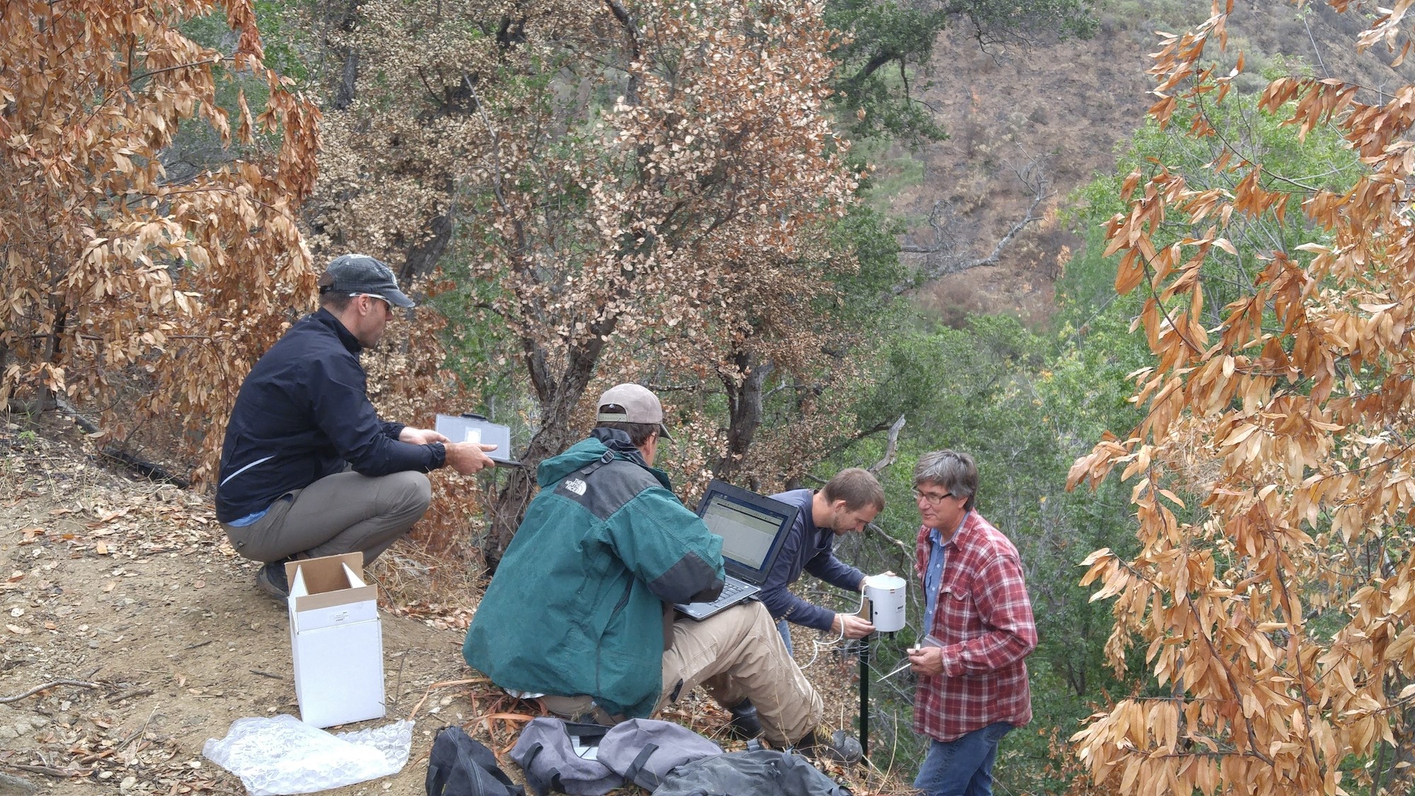
Figure 3: During Fall 2016, USGS and CGS researchers install a rain near Pfeiffer Falls in the Soberanes Fire burn area to measure the rainfall intensities that trigger post-fire debris flows.
Contacts: Jeremy Lancaster (CGS), Nina Oakley (DRI and CW3E), John Stock (USGS), F.M. Ralph (CW3E)
Congressional Briefing on “A New Frontier in Water Operations: Atmospheric Rivers, Subseasonal-to-Seasonal Predictions and Weather Forecasting Technology”
July 27, 2016
An interagency, cross-disciplinary team of experts recently convened in Washington to provide Congressional staff with a briefing on atmospheric rivers, subseasonal-to-seasonal precipitation prediction needs, and the benefits of enhanced predictive forecasting technology to the future of water management.
Attendees heard from a diverse panel of experts representing a broad spectrum of perspectives, including government engagement by the National Weather Service and the U.S. Army Corps of Engineers, scientific findings presented by the Scripps Institution of Oceanography, and regional impacts to stakeholders represented by the Western States Water Council.
This briefing highlighted CW3E’s major effforts on atmospheric river science, monitoring and predictions, and their application to possible new water management strategies, such as Forecast-Informed Reservoir Operations (FIRO; /FIRO/), which is co-led by CW3E’s Director, F. Martin Ralph. Roughly 40 people attended, including representatives of congressional offices, committees, ACWA, federal agencies and other groups.
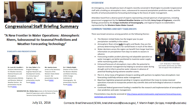
Click here for a summary.
Contact: F. Martin Ralph (mralph@ucsd.edu)
CW3E Publication Notice
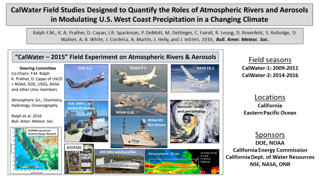
CalWater Field Studies Designed to Quantify the Roles of Atmospheric Rivers and Aerosols in Modulating U.S. West Coast Precipitation in a Changing Climate
November 28, 2016
Ralph F.M., K. A. Prather, D. Cayan, J.R. Spackman, P. DeMott, M. Dettinger, C. Fairall, R. Leung, D. Rosenfeld, S. Rutledge, D. Waliser, A. B. White, J. Cordeira, A. Martin, J. Helly, and J. Intrieri, 2016: CalWater Field Studies Designed to Quantify the Roles of Atmospheric Rivers and Aerosols in Modulating U.S. West Coast Precipitation in a Changing Climate. Bull. Amer. Meteor. Soc. 97, yyy-zzz. doi: 10.1175/BAMS-D-14-00043.1.
This paper summarizes the 8-year-long CalWater program of field studies, from planning to field operations and analysis efforts. It also summarizes the major motivations for the program as well as science gaps addressed, and serves as the standard reference for future CalWater analysis papers.
Contact: F. Martin Ralph (mralph@ucsd.edu)
Abstract
Quantifying the roles of atmospheric rivers and aerosols in modulating U.S. West Coast precipitation, water supply, flood risks and drought in a changing climate.
The variability of precipitation and water supply along the U.S. West Coast creates major challenges to the region’s economy and environment, as evidenced by the recent California drought. This variability is strongly influenced by atmospheric rivers (AR), which deliver much of the precipitation along the U.S. West Coast and can cause flooding, and by aerosols (from local sources and transported from remote continents and oceans) that modulate clouds and precipitation. A better understanding of these processes is needed to reduce uncertainties in weather predictions and climate projections of droughts and floods, both now and under changing climate conditions.
To address these gaps a group of meteorologists, hydrologists, climate scientists, atmospheric chemists, and oceanographers have created an interdisciplinary research effort, with support from multiple agencies. From 2009-2011 a series of field campaigns (CalWater 1) collected atmospheric chemistry, cloud microphysics and meteorological measurements in California and associated modeling and diagnostic studies were carried out. Based on remaining gaps, a vision was developed to extend these studies offshore over the Eastern North Pacific and to enhance land-based measurements from 2014-2018 (CalWater 2). The data set and selected results from CalWater 1 are summarized here. The goals of CalWater-2, and measurements to date, are then described.
CalWater is producing new findings and exploring new technologies to evaluate and improve global climate models and their regional performance and to develop tools supporting water and hydropower management. These advances also have potential to enhance hazard mitigation by improving near-term weather prediction and subseasonal and seasonal outlooks.