CW3E Publication Notice
Highlighting two new publications on the development of a regional coupled ocean–atmosphere model
August 2, 2023
Two new papers on the development of the regional coupled ocean–atmosphere model were published in Geoscientific Model Development. This research contributes to CW3E’s 2019–2024 Strategic Plan to improve weather, hydrology, and coupled modeling capabilities that can be applied to the western United States. In our previous work, we have demonstrated that using coupled ocean–atmosphere model can improve the forecast of atmospheric rivers (ARs) associated with strong sea surface temperature changes. The new implements of the coupled model can allow us to investigate the sub-seasonal to seasonal predictability of ARs and study the physics of the ocean, wave, and sea-ice under AR conditions. Early research indicates ocean-atmosphere coupling can improve extended range (7-14 days) forecasts of atmospheric rivers. The work from the papers describes the new methods for coupling dynamics that can be applied to ARs to test how they might further improve AR forecasts.
The two new papers describe the implementations of waves and sea ice modules in the coupled model SKRIPS (Scripps–KAUST Regional Integrated Prediction System). The first paper, entitled “Waves in SKRIPS: WAVEWATCH III coupling implementation and a case study of Tropical Cyclone Mekunu”, by Rui Sun (SIO), Alison Cobb (SIO), Ana B Villas Bôas (Colorado School of Mines), Sabique Langodan (KAUST), Aneesh C. Subramanian (CU Boulder), Matthew R. Mazloff (SIO), Bruce D. Cornuelle (SIO), Arthur J. Miller (SIO), Raju Pathak (KAUST), Ibrahim Hoteit (KAUST). In this work, the wave model WAVEWATCH III model into the regional coupled model SKRIPS with flexibility options, meaning the coupled system can run with or without the wave component. The implementations also include the effect of Stokes drift, Langmuir turbulence, sea surface roughness, and wave-induced momentum fluxes. The skill of the newly implemented model is tested using a series of coupled and uncoupled simulations of tropical cyclone Mekunu, which occurred in the Arabian Sea in May 2018, using a series of 20-ensemble member experiments. Although the characteristics of the tropical cyclone are not significantly different due to the effect of surface waves when using different parameterizations, the coupled models better capture the minimum pressure and maximum wind speed. Moreover, in the region of the cold wake, the coupled model successfully captures the effect due to Langmuir turbulence that cools down the sea surface temperature by about 0.5 degrees and deepens the mixed layer by about 20 meters.
The second paper entitled “Conservation of heat and mass in P-SKRIPS version 1: the coupled atmosphere–ice–ocean model of the Ross Sea” by Alena Malyarenko (Victoria University of Wellington; NIWA), Alexandra Gossart (Victoria University of Wellington), Rui Sun (SIO), Mario Krapp (GNS Science). This paper addresses the conservation of heat and mass fluxes between coupled models when sea-ice exists, which is often overlooked due to computational difficulties. At the regional scale, the non-conservation of water and energy can lead to model drift over multi-year model simulations. A new version of the SKRIPS coupled model setup for the Ross Sea region is proposed (P-SKRIPS, version 1, a). The development includes full conservation of heat and mass fluxes transferred between the climate (PWRF) and sea ice–ocean (MITgcm) models. We examine open water, sea ice cover, and ice sheet interfaces. We show evidence of the flux conservation in the results of a 1-month-long summer and 1-month-long winter test experiment. P-SKRIPS v.1 shows the implications of conserving heat flux over the Terra Nova Bay and Ross Sea polynyas in August 2016, eliminating the mismatch between total flux calculation in PWRF and MITgcm up to 922 W /m-2.
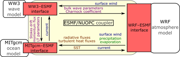
Figure 1: The schematic description of the SKRIPS regional coupled ocean–atmosphere model. The yellow block is the ESMF/NUOPC coupler; the white blocks are the ocean and atmosphere components; the red blocks are the implemented MITgcm–ESMF, WRF–ESMF, and WW3–ESMF interfaces.
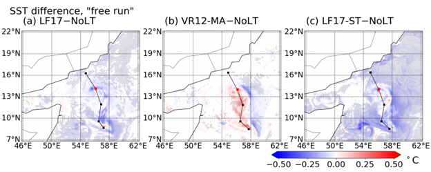
Figure 2: The snapshots of the ensemble-averaged SST difference. Panels (a-c) show the SST difference between the simulations with Langmuir turbulence (CPL.LF17, CPL.VR12-MA, and CPL.LF17-ST) and without Langmuir turbulence (CPL.NoLT). The markers indicate the regions where the SST difference is significant (P < 0.05).
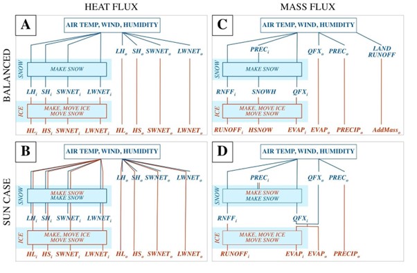
Figure 3: Exchanged flux pathways through snow and sea ice routines in PWRF (blue) and MITgcm (red), (A) and (C) represent the SKRIPS set up and (B) and (D) the P-SKRIPS. The i and o indices represent the variable over ice and ocean, respectively. LH, SH, SWNET and LWNET stand for latent heat, sensible heat, net shortwave radiation and net long wave radiation in W/m2. Prec stands for precipitation, QFX and EVAP for surface evaporation and RNFF for surface meltwater runoff (all in mm). SNOWH is the variable for the amount of snow on sea ice (in m). In panels (B) and (D) the overlapping blue and red lines indicate the fluxes are re-calculated by MITgcm and WRF.
Sun, R., Cobb, A., Villas Bôas, A.B., Langodan, S., Subramanian, A.C., Mazloff, M.R., Cornuelle, B.D., Miller, A.J., Pathak, R. and Hoteit, I., 2023. Waves in SKRIPS: WAVEWATCH III coupling implementation and a case study of Tropical Cyclone Mekunu. Geoscientific Model Development, 16(12), pp.3435-3458. https://doi.org/10.5194/gmd-16-3435-2023
Malyarenko, A., Gossart, A., Sun, R. and Krapp, M., 2023. Conservation of heat and mass in P-SKRIPS version 1: the coupled atmosphere–ice–ocean model of the Ross Sea. Geoscientific Model Development, 16(11), pp.3355-3373. https://doi.org/10.5194/gmd-16-3355-2023