CW3E Talks Atmospheric Rivers with Solana Beach Day Camp

CW3E Talks Atmospheric Rivers with Solana Beach Day Camp

June 29, 2022

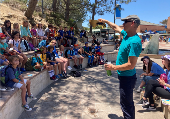
CW3E Lead Engineer Douglas Alden provided an engaging presentation on water supply, meteorological instrumentation, and atmospheric rivers for roughly 40 kindergarten through 5th grade campers and their counselors from the Solana Beach Day Camp after their visit to the Birch Aquarium at Scripps. The campers learned some of the many ways in which CW3E is working with partners to improve reservoir water storage through research into atmospheric rivers and associated extreme precipitation. Observations are a critical part of this work, and campers discovered how a tipping bucket rain gauge measures precipitation. They also got a close look at a dropsonde and a radiosonde, which are used by CW3E to study atmospheric river development and strength. CW3E appreciated the opportunity to get to know the campers and introduce them to our work!

CW3E Event Summary: 9-12 June 2022

CW3E Event Summary: 9-12 June 2022

June 15, 2022

Click here for a pdf of this information.

An Unseasonably Strong Atmospheric River Produced Heavy Rainfall and Flooding in the Pacific Northwest, Northwest Wyoming, and Southern Montana

  • An atmospheric river (AR) impacted the Pacific Northwest and Northern California between 9 and 12 June
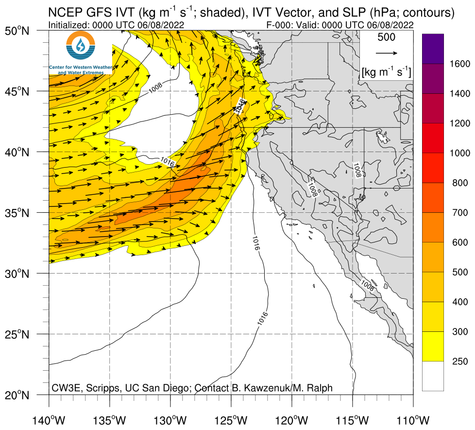
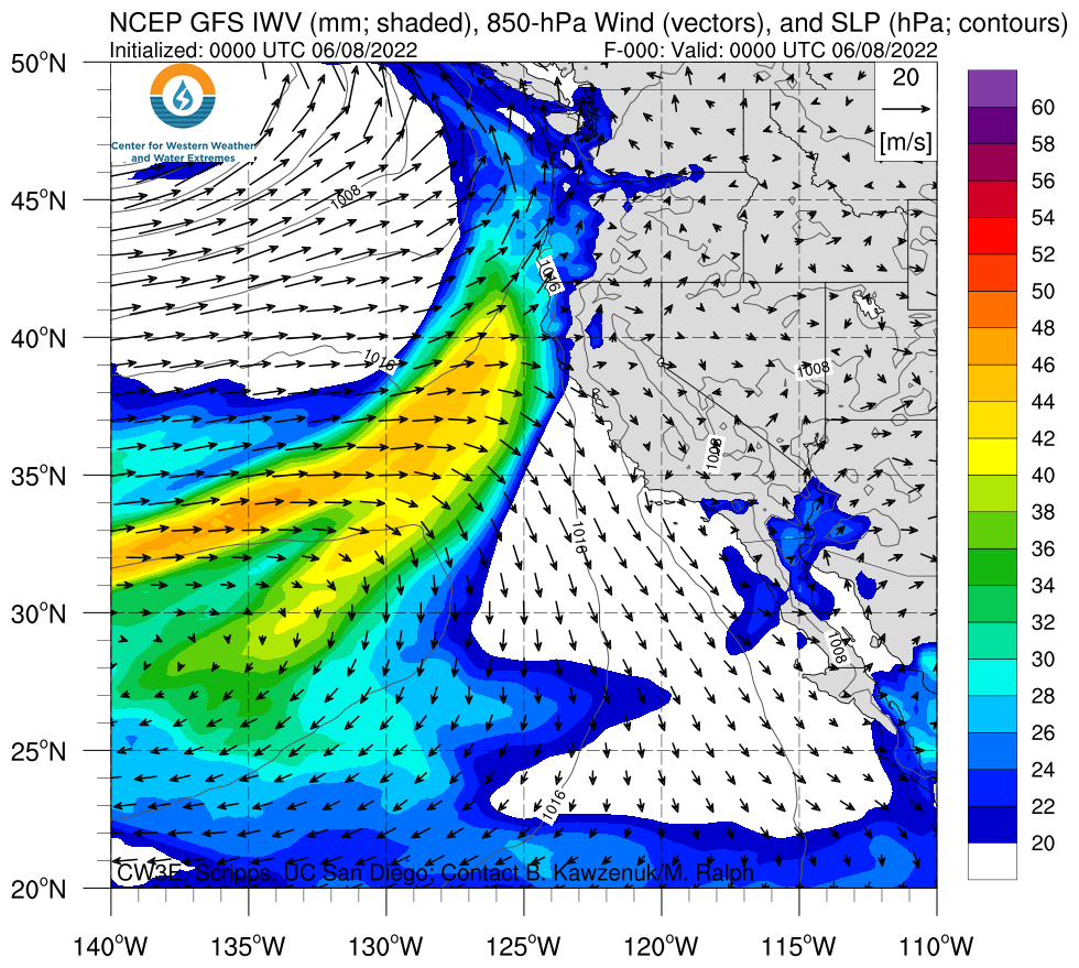
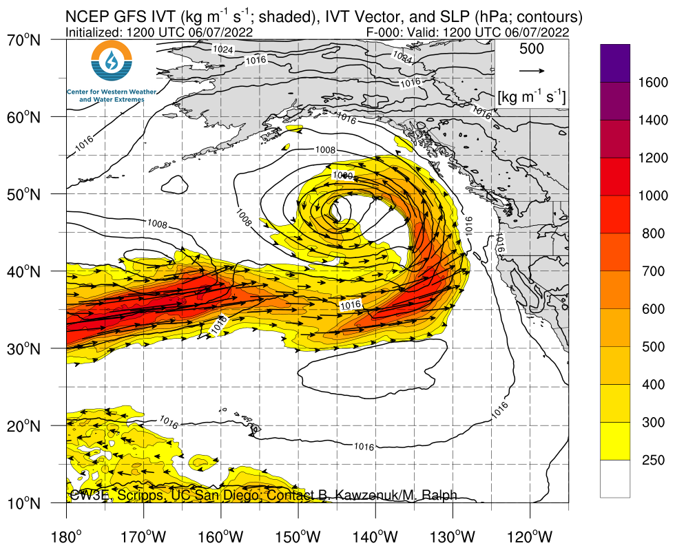
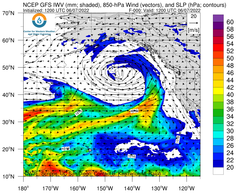
  • An AR 5 (based on the Ralph et al. 2019 AR Scale) was observed in coastal Oregon, where AR conditions persisted for more than 60 consecutive hours with maximum IVT values exceeding 1100 kg m−1 s−1
  • AR 4 conditions extended inland across eastern Oregon and northern California
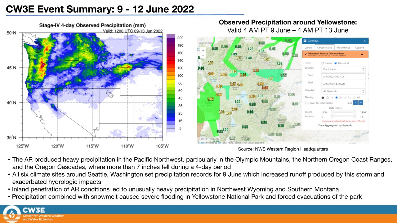
  • Maximum total precipitation up to 7 inches fell in parts of the Oregon Cascades with more than 2 inches elsewhere throughout Oregon and Washington
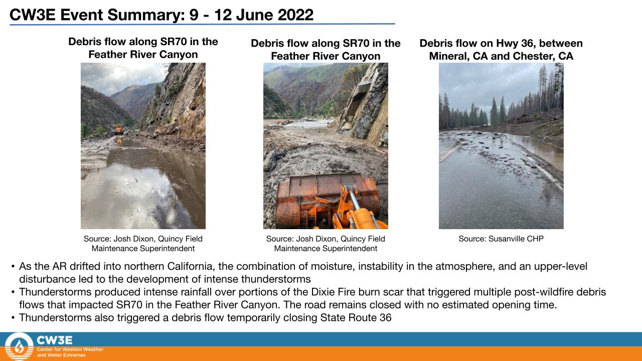
  • Thunderstorms produced intense rainfall over portions of the Dixie Fire burn scar that triggered multiple post-wildfire debris flows that impacted SR70 in the Feather River Canyon
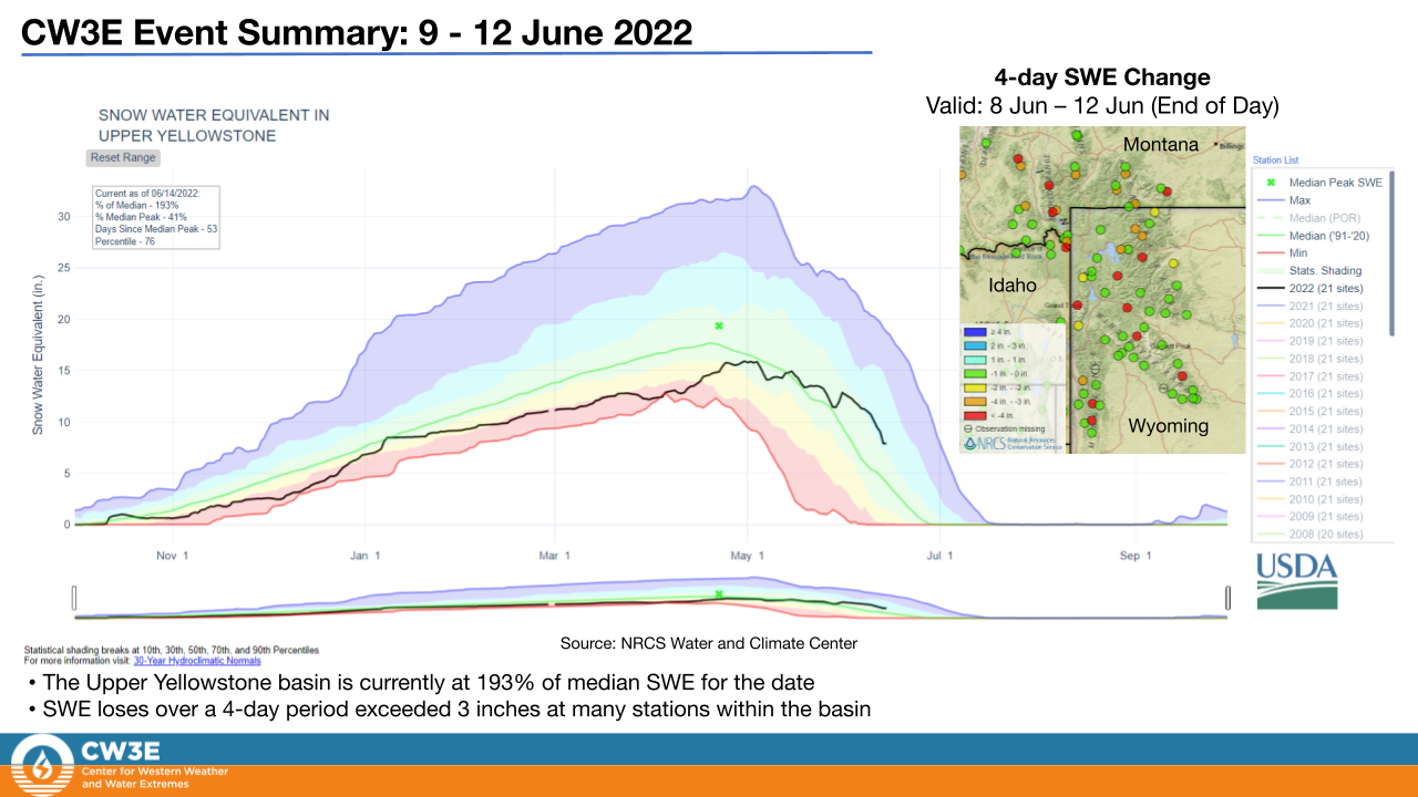
  • A favorable atmospheric environment for severe weather over Yellowstone National Park, including diurnally driven instability and low-level shear, was enhanced by the presence of moisture associated with the AR. This resulted in intense rainfall and heavy snowmelt in Northwest Wyoming and Southern Montana forcing evacuations of parts of Yellowstone National Park
  • Stream gauges along rivers within Yellowstone National Park experienced flows well above previous records

Click images to see loops of NAM IVT/IWV analyses

Valid 0000 UTC 8 June – 1800 UTC 13 June 2022


Summary provided by Shawn Roj, Samuel Bartlett, Chad Hecht, Nina Oakley, J. Kalansky, B. Kawzenuk, F.M. Ralph; 15 June 2022

To sign up for email alerts when CW3E post new AR updates click here.

*Outlook products are considered experimental

CW3E Publication Notice: Summarizing Relationships Among Landfalling Atmospheric Rivers, Integrated Water Vapor Transport, and California Watershed Precipitation 1982–2019

CW3E Publication Notice

Summarizing Relationships Among Landfalling Atmospheric Rivers, Integrated Water Vapor Transport, and California Watershed Precipitation 1982–2019

June 9, 2022

The paper “Summarizing Relationships Among Landfalling Atmospheric Rivers, Integrated Water Vapor Transport, and California Watershed Precipitation 1982–2019” by Joseph Ricciotti and Jay Cordeira was recently published in the American Meteorological Society Journal of Hydrometeorology. Ricciotti is a former graduate student of Cordeira at Plymouth State University whose M.S. thesis was sponsored by the USACE-funded Forecast Informed Reservoir Operations program and contributes to the goals of CW3E’s 2019-2024 Strategic Plan to support atmospheric river (AR) research and applications.

The study investigates the relationship among landfalling ARs, integrated vapor transport (IVT) associated with landfalling ARs, and watershed mean areal precipitation (MAP) for a 38-year period over California. On average, the daily average IVT magnitude at different coastal locations explains ~34% of the variance in annual watershed MAP across 140 HUC-8 watersheds with large spatial variability across California. Further investigation of the IVT magnitude and direction at coastal locations illustrated that accounting for water vapor transport direction increases the explained variance in annual MAP to an average of 45%, with highest values (~65%) occurring in watersheds over northern and coastal California similar to prior studies by CW3E authors. Similar investigation of the lower-tropospheric water vapor flux vector at 850 hPa and 925 hPa revealed further increases in the explained variance in annual MAP to an average of >50%.

The results of this study (1) emphasize the importance of both IVT direction and water vapor flux altitude to watershed MAP, (2) align well with previous studies for select locations that highlight the importance of upslope (i.e., lower tropospheric) water vapor flux during landfalling ARs and precipitation, and (3) motivate the development of AR-related and watershed-centric forecast tools that incorporate IVT direction and water vapor flux altitude parameters in addition to IVT magnitude.

Figure 6a,b of Ricciotti and Cordeira (2022): California watershed maximum correlation values (r2) for (a) IVT magnitude and watershed MAP and (b) projected IVT and watershed MAP. What does this figure imply? A: Incorporating both IVT magnitude and direction in order to emphasize key upslope processes during landfalling ARs helps explain more of California’s watershed precipitation than IVT magnitude alone, especially across northern California.

Ricciotti, J. A., and J. M. Cordeira, 2022: Summarizing Relationships Among Landfalling Atmospheric Rivers, Integrated Water Vapor Transport, and California Watershed Precipitation 1982–2019. J. Hydromet., Early Online Release: https://doi.org/10.1175/JHM-D-21-0119.1.

CW3E AR Update: 7 June 2022 Outlook

CW3E AR Update: 07 June 2022 Outlook

June 7, 2022

Click here for a pdf of this information.

Atmospheric River to Bring Precipitation to the Pacific Northwest

  • A strong late-season atmospheric river consisting of two primary pulses is forecast to impact the Pacific Northwest later this week.
  • The initial pulse of the AR will make landfall along the Oregon/Washington border on Thursday morning, followed by the period of highest intensity AR conditions on Thursday evening.
  • Forecast models suggest the potential for a mesoscale frontal wave that could bring a secondary pulse of enhanced IVT to coastal Washington and Oregon on Friday.
  • There is considerable uncertainty within the GFS and ECMWF models regarding the intensity of the latter portion of the AR event, potentially limiting or enhancing precipitation during the late stages of the event.
  • This atmospheric river is forecasted to bring 2-3 inches of precipitation to mountainous regions of Washington and Oregon during the end of this week.
  • A combination of heavy rain and seasonal snow melt could increase the potential for flooding over western and central Washington.


Click images to see loops of GFS IVT & IWV forecasts

Valid 1200 UTC 7 June – 1200 UTC 12 June 2022


Summary provided by S. Bartlett, C. Castellano, C. Hecht, S. Roj, J. Kalansky, and F. M. Ralph; 7 June 2022

To sign up for email alerts when CW3E post new AR updates click here.

*Outlook products are considered experimental

CW3E AR Update: 3 June 2022 Outlook

CW3E AR Update: 03 June 2022 Outlook

June 3, 2022

Click here for a pdf of this information.

Atmospheric River to Bring Precipitation to Portions of Northern California and Oregon

  • An atmospheric river of intensity AR3 on the Ralph et al. (2019) AR scale is forecast to make landfall along the coast of Northern California and Oregon.
  • The AR will initially make landfall in Oregon, then slide down the coast and eventually dissipate over Northern California over the next three days.
  • This event will primarily bring precipitation to the higher elevations over far Northern California, western Oregon, and western Washington, with more than 3 inches possible in some areas.
  • Compared to the 12Z GFS, the 12Z ECMWF is forecasting higher precipitation totals over the 3-day event in the Northern California Coast Ranges and southern Cascades in Oregon.
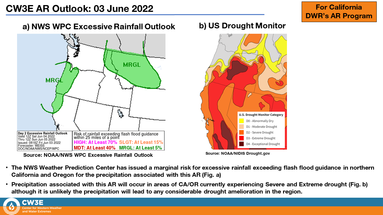
  • Precipitation associated with this AR3 has been classified by the NWS WPC within the Excessive Rainfall Outlook, which highlights a marginal risk of flash flooding to occur in the region of this event.
  • This AR will bring much needed late-season precipitation to regions currently experiencing Extreme/Severe drought conditions, with the added benefit of reduced wildfire conditions for a short period of time.
  • High intensity AR3 events are not frequent this time of year. For example, in Bodega Bay (North of San Francisco), between 1980 to 2017 there were only ~25 days with AR3 conditions during the month of June.


Click images to see loops of GFS IVT & IWV forecasts

Valid 1200 UTC 3 June – 1200 UTC 6 June 2022


Summary provided by S. Bartlett, C. Castellano, C. Hecht, S. Roj, J. Kalansky, and F. M. Ralph; 3 June 2022

To sign up for email alerts when CW3E post new AR updates click here.

*Outlook products are considered experimental

Hydrologic Forecasting Postdoc Position at Scripps Institution of Oceanography, La Jolla, CA

Hydrologic Forecasting Postdoc Position at Scripps Institution of Oceanography, La Jolla, CA

June 2, 2022

To apply: please send CV, cover letter and 3 references to Dr. Ming Pan, m3pan@ucsd.edu

The Center for Western Weather and Water Extremes (CW3E) at the Scripps Institute of Oceanography (SIO) is seeking a postdoctoral scientist to (1) investigate the skills of existing hydrologic forecasts in Western US, (2) perform hydrologic modeling experiments for the purpose of hydrologic reanalysis, near real time monitoring, and ensemble forecasting, (3) improve skill of the aforementioned modeling work through measures like better forcing inputs, next-gen modeling framework, and data assimilation.

CW3E consists of 50+ passionate scientists who develop and operate state-of-the-art modeling (e.g., CW3E version of the Weather Research and Forecasting model tailored for extreme events over the Western US – West-WRF) and observing (e.g., Atmospheric River Reconnaissance) systems to improve forecast capability for weather and water extremes in Western US and to enable more effective policies and practices in the region. CW3E aims to revolutionize the physical understanding, observations, predictions/projections of extreme events in Western North America at different time scales from days to decades, including atmospheric rivers, the North American summer monsoon and their impacts on floods, droughts, hydropower, ecosystems and economy. CW3E practices UCSD Principles of Community to create a climate of fairness, cooperation, and professionalism.

This position is in part supported by CW3E’s Forecast Informed Reservoir Operations (FIRO) program. FIRO is a reservoir-operation strategy that uses enhanced monitoring and improved weather and water forecasts to inform decision making to selectively retain or release water from reservoirs to optimize water supply reliability and environmental co-benefits and to enhance flood-risk reduction.

The postdoc will work closely with Dr. Ming Pan and the weather and hydrology teams at CW3E. Applicants should be self-motivated and hard-working. Good written and verbal communication skills, including the ability to produce scientific publications and presentations and meet project milestones are required. The ideal candidate would have experience with hydrologic modeling and ensemble forecasting, model cal/val, and flood/drought analysis. Strong analytical backgrounds with a Ph.D. in meteorology, hydrology or environmental or civil engineering is preferred. Programming experience working in a Linux/Unix environment with experience in scripting languages such as Python and R as well as in supercomputing is desired.

The University of California is an Equal Opportunity/Affirmative Action Employer. All qualified applicants will receive consideration for employment without regard to race, color, religion, sex, national origin, disability, age, protected veteran status, gender identity or sexual orientation. Position will remain open until filled.

CW3E Welcomes Dr. Jason Cordeira

CW3E Welcomes Dr. Jason Cordeira

June 2, 2022

Dr. Jay Cordeira joined the Center for Western Weather and Water Extremes (CW3E) at the UCSD Scripps Institution of Oceanography in June 2022 and will serve as the Center’s Atmospheric Science and Applications Manager. The goal of this new position is to oversee all aspects of the growing portfolio of atmospheric river (AR)-related research and applications within CW3E sponsored by, among others, the California AR Program, the Forecast Informed Reservoir Operations Program, and the Cooperative Institute for Research to Operations in Hydrology. In coordination with the CW3E Management team, he will help develop new scientific and programmatic strategies to expand AR-related research and applications within the “Research and Operations” (RAOP) framework across the Western, Central, and Eastern US.

Dr. Cordeira earned his B.S. in Meteorology from Plymouth State University (PSU) in 2005 prior to obtaining both an M.S. (2008) and Ph.D. (2011) in Atmospheric Science from the University at Albany. He completed a Post-Doc with the National Academies of Science within the NOAA Physical Sciences Division Water Cycle Branch in 2012 and was a Research Meteorologist for a weather software company named EarthRisk Technologies in 2013. Later in 2013 he joined the faculty at his Alma Mater (PSU) as an Assistant Professor and later an Associate Professor prior to joining CW3E in 2022.

While at PSU, Dr. Cordeira led a collaborative and externally funded research program focused on analysis, forecasting, and visualization of hydrometeorology processes dedicated to developing decision support tools and situational awareness applications for U.S. West Coast water resources management, precipitation extremes, and flooding. His research was in collaboration with CW3E where he contributed to multiple different facets of Forecast Informed Reservoir Operations, the California AR Program, and Atmospheric Rivers Reconnaissance, including the co-development of many of CW3E’s AR-related deterministic and ensemble forecast tools.

He also taught in the undergraduate B.S. Meteorology and graduate M.S. Applied Meteorology degree programs at PSU with a focus on applied curriculum in areas of tropical meteorology, mesoscale meteorology, numerical weather prediction, and computer applications in meteorology. He is passionate about mentoring early-career scientists and supporting their participation in externally funded research projects through various research experiences. While at PSU he advised 18 Graduate Students, mentored more than 50 Undergraduate Students in research and forecasting initiatives, and was the Director of the NSF-funded Northeast Partnership for Atmospheric and Related Studies (NEPARS) Research Experiences for Undergraduates program.

CW3E Co-hosts 2022 Southwest Extreme Precipitation Symposium (SWEPSYM)

CW3E Co-hosts 2022 Southwest Extreme Precipitation Symposium (SWEPSYM)

May 9, 2022

The Southwest Extreme Precipitation Symposium (SWEPSYM) is annual conference co-hosted by the Floodplain Management Association and CW3E that brings together the scientific community and water managers in the Southwest. With a focus on the Southwest, SWEPSYM shares technical and scientific information and knowledge about the various factors responsible for producing extreme precipitation and the hydrologic processes. The conference is at the interface of research and applications. It has four main objectives:

  1. Focus attention on precipitation extremes in the Southwest region of North America.
  2. Share technical and scientific information and knowledge about the various factors responsible for producing extreme precipitation and the hydrologic processes responsible for generating runoff in semi-arid and arid areas.
  3. Advance our understanding of the causes of extreme precipitation with the hope of increasing the warning time in advance of extreme precipitation ranging from droughts to floods.
  4. Exchange information on engineering, water management, flood control, agricultural, and other Southwest regional needs for information on extreme precipitation.

The theme of SWEPSYM 2022 is “Exploring Extreme Conditions Impacting Water Supply from the Colorado River Basin”. The Colorado River Basin provides water to nearly 40 million people and irrigates about 5.5 million acres of agricultural lands in the Southwestern US and Mexico. Recent climate change impacts are altering the extreme conditions in the basin, including both droughts and floods. Exploring the past, current, and potential future impacts from climate changes on droughts and floods was covered by ten speakers over two half-days virtually on April 19th and 20th.

CW3E researchers Zhenhai Zhang, Mu Xiao, and Kerstin Paulsson gave presentations. Zhenhai’s presentation explored the characteristics and origins of extreme snow days and weeks in the Yampa River Basin, including the role of inland penetrating atmospheric rivers. Mu gave a presentation about examining hydrological modeling with remote sensing products in the Colorado River Basin with a focus on surface temperature and snowpack. Kerstin introduced a new long-term hydrometeorological observing network in the Upper Yampa River Basin, which is a collaboration between CW3E, Colorado Mountain College, and Yampa Valley Sustainability Council to monitor soil moisture in the Upper Yampa River Basin with the support from the Upper Yampa Water Conservancy District. Anna Wilson of CW3E helped moderate the event.

The presentations from this year’s Symposium, including video, audio, slides (PDF format), and abstracts, are now available on the SWEPSYM website.


CW3E Publication Notice: Running a scientific conference during pandemic times

CW3E Publication Notice

Running a scientific conference during pandemic times

May 4, 2022

The paper “Running a scientific conference during pandemic times” was recently published in the Bulletin of the American Meteorological Society by authors René Garreaud (Departamento de Geofísica, Universidad de Chile), M. Ralph and A Wilson, (CW3E), A.M. Ramos (Instituto Dom Luiz, Faculdade de Ciências, Universidade de Lisboa), J. Eiras-Barca (Universidade de Vigo), H. Steen-Larsen (University of Bergen), J.Rutz (NWS Western Region), C. Albano (Desert Research Institute), N. Tilinina (Shirshov Institute of Oceanology), M. Warner (U.S. Army Corps of Engineers), M. Viale (Instituto Argentino de Nivología, Glaciología y Ciencias Ambientales), R. Rondanelli (Departamento de Geofísica, Universidad de Chile, Center for Climate and Resilience Research), J. McPhee (Departamento de Ingeniería Civil, Universidad de Chile), R.Valenzuela (CW3E, Universidad de O’Higgins) and I. Gorodetskaya (Centre for Environmental and Marine Studies, Department of Physics, University of Aveiro). The paper contributes to the goals of CW3E’s 2019-2024 Strategic Plan to support Atmospheric River (AR) Research and Applications and Emerging Technologies by sharing insights from the 2020 Virtual International AR Symposium on running effective scientific events virtually during the pandemic.

Number of 2020 IARC participants by country.

This publication provides an overview of the 2020 IARC Virtual Symposium, the challenges faced in hosting an event during the pandemic, and the lessons learned in running virtual events. IARC, a bi-annual convening first hosted in 2016, aims to create, sustain, and bring together the rapidly growing community of experts on ARs, connect different disciplines and stakeholders, link scientists to practitioners, users and decision makers, establish international cross-disciplinary collaboration, train the next generation of scientists, and advance the state of AR science.

Originally scheduled for the first week of October 2020 at the Universidad de Chile campus in Santiago, Chile, the 2020 IARC, as with most events across the world, faced significant obstacles in the ability to convene due to COVID-19, and ultimately was hosted as a virtual event. As summarized in Garreaud et al., holding the 2020 IARC Virtual Symposium posed many challenges logistically in terms of planning, organization, technology, and structure of the event. However, despite these challenges, the symposium virtually brought together over one hundred international, cross-disciplinary and diverse AR researchers, providing a valuable opportunity to the research community to convene and share important scientific advancements (Figure). The paper outlines the many lessons learnt and outcomes from the 2020 IARC Virtual Symposium, including logistical lessons in structuring a virtual event, presentation organization, and virtual participant interaction.

This work highlights the important implications from the 2020 IARC, providing a resource for planning effective and successful virtual events and continuing the advancement of scientific research during pandemic times.

Garreaud, R., Ralph, M., Wilson, A., Ramos, A.M., Eiras-Barca, J., Steen-Larsen, H., Rutz, J., Albano, C., Tilinina, N., Warner, M., Viale, M., Rondanelli, R., McPhee, J., Valenzuela, R., & Gorodetskaya, I. (2022). Running a scientific conference during pandemic times, Bulletin of the American Meteorological Society, (published online ahead of print 2022). https://journals.ametsoc.org/view/journals/bams/aop/BAMS-D-22-0023.1/BAMS-D-22-0023.1.xml.
CW3E Welcomes Dr. Mu Xiao

CW3E Welcomes Dr. Mu Xiao

April 29, 2022

Dr. Mu Xiao joined CW3E as a research hydrologist in April 2022. He earned his master’s degree in civil and Environmental Engineering from University of Washington. He received his Ph.D. degree in the Department of Geography at University of California, Los Angeles. The major research area of his doctoral study is hydrology and water resources. After graduation, he worked at Arizona State University as a postdoc research scholar for two years.

Mu has been doing extensive modeling work in the field of land surface hydrology. His research interest is examining the pattern and function of terrestrial hydrology in the climate system, as well as identifying signal of hydroclimatic changes pertaining to natural variability and anthropogenic impacts. His prior research work includes exploring the characteristics and impacts of large-scale droughts in the Western United States, assessment of climatic controls on changes in surface water storage, and evaluation the changes in role of mountain snowpack in surface hydrological processes under the warming climate.

At CW3E, Mu will be working with the hydrology group under the supervision of Dr. Ming Pan. His research involves using macro scale modeling technique to evaluate the impacts of pre-snow season soil moisture on runoff production in the mountain regions. He will also be working on the hydrological monitoring and forecast system over the Western U.S. using the WRF-Hydro model. The essential goal of this project is to provide seasonal hydrological forecast for water management activities in the west.