Comet Supercomputer Pilots Extreme Ensemble for Predicting Atmospheric River Events

Comet Supercomputer Pilots Extreme Ensemble for Predicting Atmospheric River Events

October 17, 2022

Atmospheric rivers are narrow bands of moisture-laden air, often more than a thousand miles long and a few hundred miles wide, that affect precipitation around the world. Forecasting their impact is especially important in the western United States where they can account for up to 50% of total annual rainfall. They bring significant benefits, such as filling reservoirs and contributing to Sierra snowpack, but can also lead to catastrophic floods and landslides.

To gain a better understanding of atmospheric rivers, the Center for Western Weather and Water Extremes (CW3E) at Scripps Institution of Oceanography, in collaboration with the San Diego Supercomputer Center (SDSC), both located at UC San Diego, developed an unprecedented forecasting system based on a large collection of atmospheric simulations. Based on initial conditions, dynamic models and physics this collection of calculations – called an ensemble forecast – is a novel and innovative element of CW3E’s work to increase the skill of predicting the timing and magnitude and associated uncertainty of extreme precipitation events, primarily focused on atmospheric rivers.

With a goal to reliably quantify the forecast uncertainty, improve overall quality of probabilistic predictions, and better sample the distribution of extreme events, the new West-Weather Research and Forecasting (West-WRF) Near Real-Time (NRT) 200-Member Ensemble, CW3E relied on the Comet supercomputer at SDSC to supply the computing power, which has a peak performance of nearly three quadrillion operations per second. This capacity was needed to complete the ensemble’s nightly data runs in less than 10 hours, per the operational requirements of CW3E’s Atmospheric River Reconnaissance (AR Recon) Program, which improves forecasts of precipitation for water management decisions by targeting airborne observations in and around atmospheric rivers and utilizing buoy observations over the Northeast Pacific. The goal of AR Recon is to improve forecasts of the landfall and impacts of atmospheric rivers on the U.S. West Coast at lead times of one to five days.

The ensemble calculations used 1,200 Comet compute nodes to accelerate the runs, while still leaving over 700 compute nodes for other ongoing research at CW3E. It included 100 unique combinations of physics models, boundary conditions, and applied perturbations based on the stochastic kinetic energy backscatter scheme (SKEBS). The models covered a domain that ranged from the southwest of Hawaii to the western states of California, Oregon, Washington, Idaho, Nevada and Arizona, to southern Alaska. Through careful planning by CW3E and SDSC, researchers attained a 94% success rate of ensemble members finishing in time to support CW3E’s AR Recon.

Early results from ongoing analysis of the data shows the ensemble design achieved the project objectives. CW3E researchers are working to expand upon the current decision-support forecast products. The new products will address the challenges of probabilistic uncertainty in a format that is easier to understand and incorporate into decision-making. Researchers from

CW3E and SDSC are collaborating on a project to improve the performance and stability of the ensemble and expect performance increases.

With the success of the West-WRF-NRT 200-member ensemble, CW3E is exploring how to further improve the system design and performance during the 2022-2023 water season.

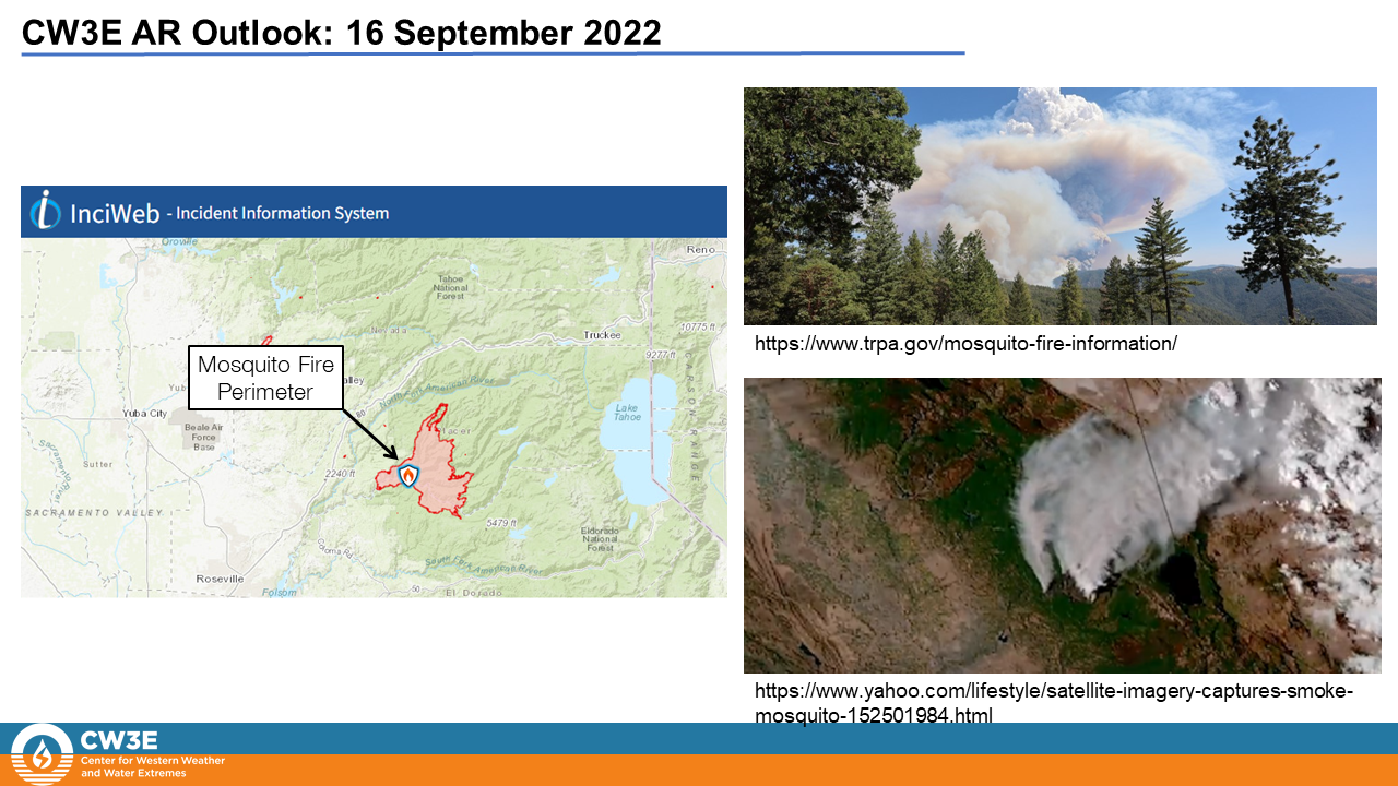
WWRF-NRT 200-Member Ensemble forecast product predicting the landfall of a strong (AR 4) on January 6th at 46.5oN, 124oW. Credit: Center for Western Weather and Water Extremes/Scripps institution of Oceanography, UC San Diego.

This work used the Comet supercomputer, which was made available by the Atmospheric River Program Phase 2 and 3 supported by the California Department of Water Resources (awards 4600013361 and 4600014294 respectively) and the Forecast Informed Reservoir Operations Program supported by the U.S. Army Corps of Engineers Engineer Research and Development Center (award USACE W912HZ-15-2-0019).

Inquiries should be directed to Daniel Steinhoff, Luca Delle Monache, or Patrick Mulrooney.

San Diego Supercomputer Center news release

CW3E Welcomes Hart Wanetick

CW3E Welcomes Hart Wanetick

October 11, 2022

Hart Wanetick joined CW3E in October 2022 as an Instrumentation Engineer on the field team. He started at Scripps in 2012 as an engineering assistant in the Hydraulics Laboratory, as well as in the field, where he worked on upgrading and maintaining hydroclimate monitoring stations in the Sierra Nevada mountains. He earned a BS in Electrical Engineering at UC Santa Cruz in 2013. Along with four other students, he designed and built the Portable Environmental Data Logger system for Google’s street view cars. This compact sensor system displayed climate and air-quality readings in real-time as a layer over Google maps application.

Following that, he spent six years developing drivers and control subsystems for cancer treatment and X-ray scanning linear accelerator systems, as well as high-powered RF amplifiers for isotope-producing cyclotrons in hospitals. He travelled to different parts of the US and Europe for R&D and maintenance of these systems. He has also studied language in Mexico and France.

As an engineer at CW3E, he will be working with the field team on designing, building, testing, and maintaining systems for hydrometeorological and hydroclimatological stations in the western US.

CW3E Publication Notice: Impacts of dropsonde and satellite observations on the forecasts of two atmospheric-river-related heavy rainfall events

CW3E Publication Notice

Impacts of dropsonde and satellite observations on the forecasts of two atmospheric-river-related heavy rainfall events

October 4, 2022

A new paper entitled “Impacts of dropsonde and satellite observations on the forecasts of two atmospheric-river-related heavy rainfall events” was recently published in Atmospheric Research and authored by National Center for Atmospheric Research scientists Wei Sun, Zhiquan Liu and Christopher Davis, and CW3E researchers F. Martin Ralph, Luca Delle Monache, and Minghua Zheng. This study (Sun et al., 2022) compares the impacts of dropsonde and satellite observations on the forecast skill of two heavy rainfall events over California during the Atmospheric River Reconnaissance (AR Recon) program in 2019. As part of CW3E’s 2019-2024 Strategic Plan, CW3E seeks to build skills in data assimilation and other emerging technologies to improve weather prediction. The work contributes to one specific goal of the Strategic Plan of improving the prediction of precipitation, ARs, and extreme events in the West through the development of data assimilation for numerical weather prediction models.

The impact of AR Recon dropsondes and satellite observations on forecasting the two AR-related heavy rainfall events was first investigated through the forecast sensitivity to observations (FSO) experiments. The FSO experiments were conducted with dropsondes, other conventional observations, and satellite radiances for both IOP3 (0000 UTC 13 February 2019) and IOP5 (0000 UTC 26 February 2019) in an adjoint-based WRFDA FSO system developed at NCAR. In both IOPs, AR Recon dropsondes show positive contributions to the forecast error reduction using the dry total energy norm metric in the downstream US West (Figure 1). In both IOPs, the accumulated contribution from dropsondes is greater than all the other conventional observation types except for the land-based soundings. In IOP3 the dropsonde contribution is comparable with each of the three satellite radiance types that are used in this study. In IOP5, the accumulated contribution of dropsondes is lower than radiance from AMSU-A and ATMS when the MHS radiance shows a negative impact on the forecast. Difference in the relative contributions of dropsondes relative to satellite data between IOP 3 and 5 can be attributable to the much greater number and spatial coverage of dropsondes and less overlap in the two observation distributions in IOP3 than in IOP5 (see Table 2 and Figure 2 in Sun et al. 2022).

To investigate the actual impact of observations on the two heavy rainfall events, eight Observing System Experiments (OSEs) were conducted for the two IOPs in this study, including Cntl (only assimilate conventional data), Drp (assimilate conventional and dropsonde data), Sat (assimilate conventional and satellite data), and DrpSat (assimilate all data) for each IOP (Table 1 of Sun et al. 2022). The model was first initialized as a 6-h forecast from 1800 UTC 12 February 2019 for IOP3, and from 1800 UTC 25 February 2019 for IOP5. For both IOPs, the highest forecast accuracy of the precipitation prediction in California is achieved when both dropsondes and satellite radiances are included in assimilation (Figure 9 in Sun et al. 2022). In IOP3, the dropsonde data slightly amplify the improvement achieved from the satellite data in terms of structure and location of the AR and attendant precipitation. In IOP5, the improvement from dropsonde data is more evident in the forecast of heavy precipitation. The influence of the dropsonde data in each case is broadly consistent with the relative coverage of dropsonde and satellite data. Further analyses on the dynamical fields show that the improved rainfall forecasts are related to the better model representation of three-dimensional circulation structure impacted by temperature. The best forecast performance acquired from the assimilation of both dropsonde and satellite data indicates the complementarity between the two data sources.

Figure 1: The averaged accumulated forecast error contribution of all used conventional observations, dropsondes, and satellite radiances in (a) IOP3 and (b) IOP5. The fraction of contribution is expressed as a percentage. The result is averaged over the 24-h, 36-h, and 48-h FSO experiments for each IOP. Figure source: from Figure 6 in Sun et al. 2022.

Sun, W., Liu, Z., Davis, C.A., Ralph, F.M., Delle Monache, L. and Zheng, M., 2022. Impacts of dropsonde and satellite observations on the forecasts of two atmospheric-river-related heavy rainfall events Atmospheric Research, 278, 106327. doi: https://doi.org/10.1016/j.atmosres.2022.106327

CW3E Welcomes Janel Mayo

CW3E Welcomes Janel Mayo

October 4, 2022

Janel Mayo joined CW3E in September 2022 and will serve as a Research Project Manager. She received her B.S. in Geology at Hofstra University in 2015 where she studied coastal geomorphology, sedimentation, and nesting shorebird conservation. She has worked with the U.S. Fish and Wildlife Service and the U.S. Geological Survey Western Ecological Research Center on nesting shorebird and seabird monitoring and productivity studies in Alaska and the South San Francisco Bay. She spent over six years as an environmental consultant on projects throughout California, working on biological surveys and reporting for special-status birds and amphibians, geomorphological studies, and wildfire prevention programs. Some of her most recent consulting work included a long-term habitat restoration project for the San Francisco Public Utilities Commission to improve water quality, flows to the reservoir, and water security within the San Antonio Watershed. Most recently, she has focused her career on project management for highly collaborative, cross-disciplinary teams with diverse stakeholders such as the U.S. Forest Service, U.S. Department of Defense, and the California Department of Fish and Wildlife. As a project manager, she has leveraged technology to create efficiencies in project tracking and reporting, as well as developed strategic resource allocation monitoring programs.

At CW3E, her role will be to support program management by assisting with project planning, tracking, and analysis. Janel will provide project management support for the Forecast Informed Reservoir Operations (FIRO) program: a key activity that develops new science, technology, and numerical modeling tools to aid future reservoir operations for flood control, water supply, and ecosystems. She will implement workflow processes and technology for FIRO implementation and transferability across the western US.

CW3E Announces Addition of Environment and Climate Change Canada Model to S2S AR Activity Outlooks

CW3E Announces Addition of Environment and Climate Change Canada Model to S2S AR Activity Outlooks

September 27, 2022

CW3E is pleased to announce the addition of the Environment and Climate Change Canada (ECCC) S2S ensemble forecast system to its public S2S website. The ECCC data, along with a second S2S ensemble forecast system from the National Centers for Environmental Prediction (NCEP), is used to create AR activity forecasts at weeks 1-3 lead time, as described on the website and documented in DeFlorio et al. 2019b. The ECCC ensemble forecast includes 21 members and the forecast is issued once per week on Thursday.

With the addition of the ECCC models, users on the CW3E website now have the option to display AR activity forecasts at weeks 1-3 lead time from either model, allowing for comparison between the ensemble systems. An example of the latest ECCC forecast, initialized on September 22, 2022 at 00Z, is shown below.

DeFlorio, M. J., D. E. Waliser, F. M. Ralph, B. Guan, A. Goodman, P. B. Gibson, S. Asharaf, L. Delle Monache, Z. Zhang, A. C. Subramanian, F. Vitart, H. Lin, and A. Kumar (2019b), Experimental subseasonal-to-seasonal (S2S) forecasting of atmospheric rivers over the Western United States. Journal of Geophysical Research – Atmospheres (S2S Special Issue), 124, 11,242-11,265. doi:10.1029/2019JD031200.

CW3E Welcomes Kayden Haleakala

CW3E Welcomes Kayden Haleakala

September 26, 2022

Kayden Haleakala joined CW3E as a Postdoctoral Scholar in September 2022. He completed his PhD in Civil and Environmental Engineering at the University of California Los Angeles (2022), researching California snowpack responses to warm storms with Drs. Mekonnen Gebremichael, Steve Margulis, Jeff Dozier, and Dennis Lettenmaier. Prior to his PhD, Kayden received his B.S. (2016) and M.S. (2017) in Civil Engineering at Santa Clara University.

Kayden's PhD work aimed to better understand rain-on-snow processes at the watershed scale. Warming winter precipitation threatens greater flood hazards in mountain environments, which underscores a need to skillfully conceptualize and predict rainfall-runoff responses over snow-covered landscapes. However, the surface stations we use for snowpack monitoring and model validation can sometimes mislead such efforts. Combining remotely sensed and in situ snow and hydrometeorological observations, Kayden's thesis (1) describes this misleading flood generation mechanism, and (2) demonstrates the role of watershed "memory" and storm sequencing in driving high-impact rain-on-snow events. In addition to snow research, Kayden has also been involved in research investigating the shifts and variability of rainfall and water supply in East Africa.

At CW3E, Kayden will be working in the hydrology group under Dr. Ming Pan and provide process understanding and modeling support for large-scale snowpack and water supply monitoring and forecasting.

CW3E Hosts Outreach Booths at the 1st Annual Yampa Youth Water Festival

CW3E Hosts Outreach Booths at the 1st Annual Yampa Youth Water Festival

September 23, 2022

On 9/21, a group of researchers from CW3E participated in the 1st Annual Yampa Youth Water Festival at the Routt County Fairground in Hayden, CO. The festival, hosted by the Upper Yampa Water Conservancy District, brought together over 400 5th grade students from Routt and Moffat counties. Groups of students rotated through 26 unique stations with activities covering a wide range of topics including weather, hydrology, biology, and water quality. The festival aims to discuss the importance of water resources in northwest Colorado by providing students with hands-on activities to learn about water and the Yampa River Basin.

CW3E kicked off the festival by launching a weather balloon in front of packed stands of cheering 5th graders (video of the launch)

Researchers from CW3E hosted two booths at the festival, one focusing on weather observations and the other focusing on meteorology. The observations booth provided a hands-on experience with instruments including weather balloons, radiosondes, an anemometer, soil moisture probes, and a tipping bucket. This booth was led by Cody Poulsen, Kerstin Paulsson, Garrett McGurk, and Holly Roth (University of Colorado Boulder). The meteorology booth included a discussion about precipitation which used an interactive lesson to teach students about temperature, weather fronts, and the water cycle. This booth was led by Sam Bartlett, Shawn Roj, and Agniv Sengupta.

The event was covered by local news outlets including the Steamboat Pilot & Today and Steamboat Radio.

The Upper Yampa Water Conservancy District produced a video document the activities of the day which featured CW3E’s weather balloon launch that kicked off the day (0:24), the booth featuring hands-on activities with weather instruments , and the interactive meteorology lesson that students participated in (1:35).

CW3E AR Update: 16 September 2022 Outlook

CW3E Update: 16 September 2022 Outlook

September 16, 2022

Click here for a pdf of this information.

Early-Season Atmospheric River to Bring Precipitation to Northern California

  • An early-season atmospheric river (AR) associated with a cutoff low is forecast to bring precipitation to Northern California and potentially help firefighting efforts at the Mosquito Fire, which has burned nearly 70,000 acres
  • Forecast models show the potential for an AR 1 (based on the Ralph et al. 2019 AR Scale) in the foothills of Northern CA near the location of the Mosquito Fire, but there is still uncertainty in the magnitude and duration of AR conditions
  • GFS and ECMWF ensemble forecasts are showing mean areal precipitation (MAP) over the North Fork American watershed around 1 inch over the next 10 days with considerable spread among individual ensemble members


Summary provided by S. Roj, S. Bartlett, C. Castellano, B. Kawzenuk, and F. M. Ralph; 16 September 2022

To sign up for email alerts when CW3E post new AR updates click here.

*Outlook products are considered experimental

CW3E Publication Notice: Unveiling Four Decades of Intensifying Precipitation from Tropical Cyclones Using Satellite Measurements

CW3E Publication Notice

Unveiling Four Decades of Intensifying Precipitation from Tropical Cyclones Using Satellite Measurements

September 16, 2022

A new study entitled “Unveiling four decades of intensifying precipitation from tropical cyclones using satellite measurements” published in Scientific Reports and authored by Center for Hydrometeorology and Remote Sensing (CHRS) scientists Eric J. Shearer, Vesta Afzali Gorooh, Phu Dinh Nguyen, Kuo-lin Hsu, and Soroosh Sorooshian at UC Irvine shows that precipitation rates and volumes from tropical cyclones have intensified globally and in every basin over four decades from 1980 to 2019. The work contributes to the goals of CW3E’s 2019-2024 Strategic Plan of Monitoring and Projections of Climate Variability and Change.

This study examines rainfall rates from tropical cyclones during an extensive chunk of the satellite period using an experimental climate data record based on the PERSIANN-Dynamic Infrared Rain rate model (PDIR), with bias correction and homogenization by the gridded monthly gauge-derived Global Precipitation Climatology Project (GPCP) v2.3. This study was motivated by climate model predictions of increases in precipitation rates and volumes from tropical cyclones (TCs) caused by anthropogenic warming which have not yet been robustly detected in historical precipitation records at time scales long enough to overcome natural climate variability due to the relatively short temporal extent of existing precipitation observations. In the study, general increases in mean and extreme rainfall rates are detected. Overall, all basins have experienced intensification in precipitation rates with a 12–18%/40-year increase in global rainfall rates. Increases in rainfall rates have boosted the mean precipitation volume of global TCs by 7–15%/40 years, with basin-specific increases as great as 59–64% over 40 years. In terms of annual inland rainfall totals, year-by-year trends are generally positive due to increasing TC frequency, slower decay over land, and more intense rainfall, with an alarming increase of 81–85% over 40 years seen from the strongest global TCs. As the global trend in precipitation rates follows expectations from warming sea surface temperatures—11.1%/°C measured, 7-14% expected due to Clausius-Clapeyron to super Clausius-Clapeyron scaling)—it is hypothesized that the observed trends could be linked to anthropogenic warming creating greater concentrations of water vapor in the atmosphere, though thermodynamic evidence alone is insufficient to robustly make this claim.

This work was partially supported by the Ridge to Reef NSF Research Traineeship (#DGE-1735040), Future Investigators in NASA Earth and Space Science and Technology (#NNH19ZDA001N-FINESST), Department of Energy (#DE‐IA0000018), California Energy Commission (#300‐15‐005), Center for Western Weather and Water Extremes (CW3E) at the Scripps Institution of Oceanography via AR Program Phase II (#4600013361) sponsored by CA-DWR, and UK Research and Innovation Global Challenges Research Fund Living Deltas Hub Grant (#NES0089261).

Figure 1: Annual precipitation rate changes of mean and upper percentile precipitation rates by intensity classifications and basins— East Pacific (EP), North Atlantic (NA), North Indian (NI), South Indian (SI), South Pacific (SP), and West Pacific (WP). Rates are calculated from the average year-to-year increase of the fitted linear model. Asterisks represent statistical significance at α=0.05. During this period, global mean sea surface temperature increased at a rate of 0.13 °C/decade. Warming in the tropics occurs at ~75% the rate of global temperatures, translating into a ~0.10 °C/decade trend in the tropics.

Shearer, E.J., Afzali Gorooh, V., Nguyen, P. et al. Unveiling four decades of intensifying precipitation from tropical cyclones using satellite measurements. Sci Rep 12, 13569 (2022). https://doi.org/10.1038/s41598-022-17640-y.

CW3E AR Update: 15 September 2022 Outlook

CW3E AR Update: 15 September 2022 Outlook

September 15, 2022

Click here for a pdf of this information.

Early-Season Atmospheric River to Bring Precipitation to California

  • An atmospheric river (AR) is forecasted to make landfall over California late Saturday night in association with a cutoff low
  • Forecast models show the potential for an AR 1/AR 2 (based on the Ralph et al. 2019 AR Scale) in coastal Northern and Central CA, but there is still some uncertainty in the magnitude and duration of AR conditions
  • The NWS Weather Prediction Center (WPC) is forecasting 1–2 inches of total precipitation over portions of the California Coast Ranges and Sierra Nevada over the next 7 days
  • As the cutoff low weakens and moves eastward, strengthening poleward moisture transport over the Four Corners Region may produce 1–3 inches of precipitation in the higher terrain of the Upper Colorado River Basin
  • Significant hydrologic impacts are not expected, but this precipitation will likely help fire management efforts to contain the Mosquito Fire, which has already burned about 64,000 acres

Click images to see loops of GFS IVT & IWV forecasts

Valid 0000 UTC 15 September – 0000 UTC 21 September 2022


Summary provided by C. Castellano, B. Kawzenuk, S. Roj, and F. M. Ralph; 15 September 2022

To sign up for email alerts when CW3E post new AR updates click here.

*Outlook products are considered experimental