CW3E Event Summary: 9-11 September 2022

CW3E Event Summary: 9-11 September 2022

September 13, 2022

Click here for a pdf of this information.

Rare Tropical Cyclone Brings Heavy Rain and Strong Winds to Southern California

  • Tropical Storm Kay and its remnants produced heavy rain and high winds across portions of Southern and Central California during 9–11 September
  • Some locations in the San Diego County mountains recorded more than 4 inches of rain on 9 September. Wind gusts of over 100 miles per hour were also recorded.
  • Precipitable water observed during this event in San Diego was 2.35 inches, the 3rd highest during the period of record and the highest value observed during the month of September
  • Heavy precipitation over desert areas resulted in roadway flooding, debris flows, and rockslides which caused prolonged roadway closures in multiple locations
  • High winds forced multiple school districts to cancel school due to hazardous conditions
  • Power outages for more than 60,000 customers were reported across Southern California
  • Heavy rain helped to bring the Fairview and Radford fires under control. As of the morning of 13 September, Inciweb was reporting 62% and 67% containment, respectively

NOAA/NESDIS/STAR – GOES-West – GEOCOLOR

Valid 0830 PDT 9 September to
1650 PDT 9 September 2022

National Hurricane Center

Valid 0800 PDT 4 September to
1700 PDT 9 September 2022

MIMIC-TPW2 Total Precipitable Water

Valid 0500 PDT 7 September – 1200 PDT 12 September 2022


Summary provided by Shawn Roj, Chris Castellano, Samuel Bartlett, Chad Hecht, J. Kalansky, F.M. Ralph; 13 September 2022

To sign up for email alerts when CW3E post new AR updates click here.

*Outlook products are considered experimental

CW3E Welcomes Yuan Yang

CW3E Welcomes Yuan Yang

September 6, 2022

Yuan Yang joined CW3E as a postdoctoral research scholar in August 2022. She received her B.E. in Hydrology and Water Resources in 2015 from Wuhan University, Hubei, China, and her Ph.D. degree in Hydraulic Engineering in 2020 from Tsinghua University, Beijing, China. In 2018, she studied at Princeton University as a visiting student, under the supervision of Prof. Eric. F. Wood and Dr. Ming Pan.

Yuan’s research focuses on high-resolution land surface hydrologic modeling at regional to global scales with the utilization of remote sensing. She proposed a grid-level distributed parameter calibration approach for large-scale hydrologic modeling. She made considerable efforts to develop a 3-hourly river discharge record globally for 2.94 million river reaches during the 40-yr period of 1980–2019. Based on this, she extracted 3-hourly flood events and their characteristics to support fine-scale flood research. She also proposed an enhanced assimilation algorithm for SWOT, an upcoming satellite providing the first global survey of Earth’s surface water, to improve global discharge simulations. Besides, she conducted research on extreme precipitation and multi-satellite precipitation merging.

At CW3E, Yuan will be working with the hydrology group under the supervision of Dr. Ming Pan. Her research activities will involve using hydrologic models and remote sensing techniques to better understand the fluxes and storages in the global water/energy cycle and its variability at seasonal and long-term scales. She will focus on the terrestrial water cycle and runoff/streamflow in particular. She will also provide hydrology research support for CW3E’s other research programs like the Atmospheric Rivers (AR) program and the Forecast Informed Reservoir Operations (FIRO) program.

CW3E Visits the Wrigley Marine Science Center

CW3E Visits the Wrigley Marine Science Center

September 6, 2022

CW3E staff Dr. Anna Wilson (Field Research Manager), Benjamin Downing (Field Researcher), and Peter Yao (Research Data Analyst) visited Wrigley Marine Science Center on August 8, 2022 to deliver a guest lecture to a University of Southern California (USC) class led by Dr. Scott Applebaum on Water and Soil Sustainability. Anna reviewed Forecast Informed Reservoir Operations, focusing on the viability assessment of implementing FIRO for Prado Dam operations, and how observations such as those taken on Catalina Island support this effort. Benjamin went into detail on the objectives behind the current effort to add 5 soil moisture and surface meteorology stations within the Santa Ana, including the watershed analysis and siting process. Peter discussed the Radar Meteorology (RADMet) station with a focus on data collection, processing, and usage from the Micro Rain Radar (MRR). The USC students were really engaged and asked lots of great questions. The group then walked up to the RADMet station and were introduced to all the instruments in person, as well as the electronics in the enclosures.

CW3E is grateful to partner with Orange County Water District, the US Army Corps of Engineers, and other collaborators on FIRO at Prado Dam, and is grateful for our relationship with Wrigley Marine Science Center professors, students, staff, and visitors. We look forward to continued engagement.

Congratulations to Dr. Sierks – CW3E Graduate Student Successfully Defends Dissertation

Congratulations to Dr. Sierks – CW3E Graduate Student Successfully Defends Dissertation

September 2, 2022

The seventh CW3E PhD student has successfully defended his dissertation. Dr. Mike Sierks’ defense was held on Monday, August 29, 2022. His dissertation title is “Distinctive Impacts of Extreme Warm Season Precipitation and Climate Change on the Vulnerable Water Resources of the Southwestern United States” and includes one chapter published in a peer reviewed journal (Sierks et al., 2020), a second chapter in the review process, and a third chapter in preparation for submission. Mike’s committee members were Marty Ralph (Chair), Jennifer Burney, Michael Dettinger, Jan Kleissl, Katharine Ricke, and Shang-Ping Xie. Funding for Mike’s dissertation came from FIRO and the AR Program, both under PI Marty Ralph.

Due to the ongoing COVID-19 health crisis, Mike could not defend his dissertation completely in person … but he was the first student to defend his dissertation in front of a hybrid audience! CW3E is incredibly proud of Mike’s success and all that he has accomplished throughout his PhD. We are so grateful to have had the opportunity to work with Mike throughout his graduate school career.

Dr. Mike Sierks during his hybrid dissertation defense.

Dr. Mike Sierks during his hybrid dissertation defense.

Dr. Mike Sierks acknowledging his glorious family during remarks after his dissertation defense.

Sierks, M.D., J. Kalansky, F. Cannon, and F. Ralph, 2020: Characteristics, Origins, and Impacts of Summertime Extreme Precipitation in the Lake Mead Watershed. Journal of Climate, 33, 2663-26680, https://doi.org/10.1175/JCLI-D-19-0387.1

CW3E Welcomes Deanna Nash

CW3E Welcomes Deanna Nash

August 29, 2022

Dr. Deanna Nash joined CW3E as a postdoctoral scholar in August 2022. She received her BA in Geography and Environmental Studies (2014) from the University of Colorado at Colorado Springs. She spent two years interning at NASA’s Jet Propulsion Laboratory (JPL) under the supervision of Dr. Duane Waliser, while obtaining her MA in Geography (2017) from California State University, Los Angeles with her advisor, Dr. Hengchun Ye. While at JPL, she assisted with the development of the Regional Climate Model Evaluation System (RCMES) while researching the impact of Atmospheric Rivers (ARs) on polar and extratropical hydroclimates. Deanna received her Ph.D. (2022) in Geography from the University of California, Santa Barbara under the supervision of Dr. Leila Carvalho. Her doctoral research was focused on dynamics of ARs that reached the complex topography of High Mountain Asia and their influences on precipitation, lightning, and landslides. Deanna was a NASA Earth and Space Science Graduate Fellow as well as a New Frontiers Initiative Graduate Fellow and spent most of her final year of her Ph.D. using the Weather Research and Forecasting Model to simulate and evaluate several extreme AR events in High Mountain Asia that resulted in devastating landslides.

At CW3E, Deanna will serve as a postdoctoral scholar under the supervision of Dr. Nina Oakley and will be working with an interdisciplinary team to address challenges around forecasting and communication of natural hazards in various communities across Southeast Alaska. She will be assessing atmospheric conditions of ARs that are associated with historical landslides, floods, and avalanches in Southeast Alaska and evaluating various forecast products to assess their value in forecasting for these hazards. She will also be evaluating climate projections to assess how the frequency and magnitude of ARs associated with these hazards may change in a warming climate. Results of these analyses will feed into the development of a warning system to reduce natural hazard-related impacts to life and property.

CW3E Hosts the First Forecast Informed Reservoir Operations Colloquium

CW3E Hosts the First Forecast Informed Reservoir Operations Colloquium

August 10, 2022

CW3E hosted the first Forecast Informed Reservoir Operations (FIRO) Colloquium at Scripps Institution of Oceanography from Monday, July 11th to Thursday, July 28th, which included 9 days of classroom lectures and hands-on exercises and 5 days with tours of FIRO watersheds. The Colloquium, which was sponsored by the U.S. Army Corps of Engineers, included activities that focused on providing participants with an overview of FIRO, meteorology and atmospheric rivers (ARs), numerical weather prediction, hydrology and hydrologic forecasting, observations and monitoring, and reservoir management.

The overarching goal of the Colloquium was to provide the next generation of atmospheric scientists, hydrologists, resource managers, policymakers, and others with an in depth look at the state-of-the-art methodologies to manage water resources in the western US amidst climate change, population growth, and other stressors to existing infrastructure. The Colloquium made use of the FIRO program that is ongoing in several different California watersheds as a framework. FIRO-type methodologies may be transferable to other locations where water input is driven by precipitation events with sufficient forecast skill. In the Western US and at all the current FIRO project locations, these events are ARs.

During the first week of the event, participants went on a field trip to the Prado Dam and learned in person about several facilities related to that project. During the second week, CW3E Field Researcher Benjamin Downing, Engineer Ethan Morris, and graduate student Cody Poulsen led an interactive tour of the Scripps Pier, and students participated in launching a weather balloon. The CW3E Summer Internship cohort was also able to join for this event.

The third week included tours of Lake Sonoma, Folsom Lake, New Bullards Bar, and Lake Oroville, where the participants learned more about FIRO studies and operations for water supply and flood protection. The local water entities provided in depth explanations of all the operational constraints on reservoir operations and how FIRO can increase the flood protection and water supply benefits without sacrificing water supply or flood protection.

FIRO Colloquium attendees and instructors.

The FIRO Colloquium group during Orange County Water District’s groundwater recharge facilities downstream of Prado Dam.

The FIRO Colloquium group during tour of Sonoma Water’s rubber dam and fish ladder facility.

CW3E Publication Notice: Winter Wet-Dry Weather Patterns Driving Atmospheric Rivers and Santa Ana Winds Provide Evidence for Increasing Wildfire Hazard in California

CW3E Publication Notice

Winter Wet-Dry Weather Patterns Driving Atmospheric Rivers and Santa Ana Winds Provide Evidence for Increasing Wildfire Hazard in California

July 26, 2022

A new study finds that weather patterns are changing in a way that favors fire weather at the expense of precipitation in Southern California. The paper Winter wet–dry weather patterns driving atmospheric rivers and Santa Ana winds provide evidence for increasing wildfire hazard in California was recently published in Climate Dynamics by authors Kristen Guirguis (CW3E), Alexander Gershunov (CW3E), Benjamin Hatchett (Desert Research Institute), Tamara Shulgina (CW3E), Michael DeFlorio (CW3E), Aneesh Subramanian (University of Colorado Boulder), Janin Guzman-Morales (University of California, Santa Barbara), Rosanna Aguilera (Scripps Institution of Oceanography), Rachel Clemesha (Scripps Institution of Oceanography), Tom Corringham (CW3E), Luca Delle Monache (CW3E), David Reynolds (University of Colorado Boulder), Alex Tardy (National Weather Service), Ivory Small (National Weather Service), and Marty Ralph (CW3E). The work contributes to the goals of CW3E’s 2019-2024 Strategic Plan to support Subseasonal to Seasonal (S2S) Prediction of Extreme Weather and Monitoring and Projections of Climate Variability and Change.

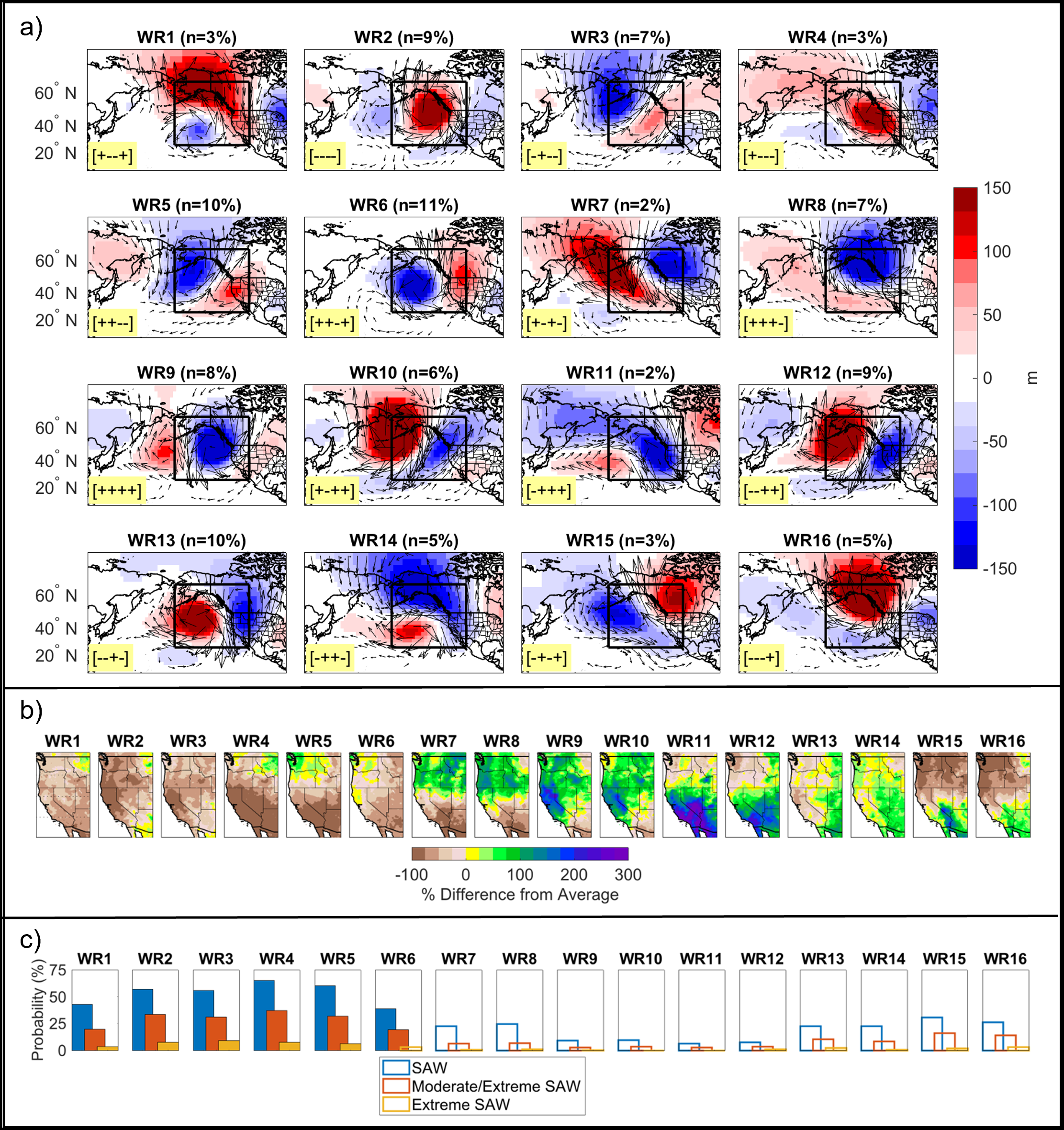
This study investigated daily phase relationships between four key drivers of atmospheric variability over the North Pacific Ocean, known as the Baja-Pacific, Alaskan-Pacific, Canadian-Pacific, and Offshore-California modes. These modes are collectively called “North Pacific Modes”, or “NP4 Modes”, and they are important drivers of atmospheric river (AR) landfalls and precipitation in California on daily to seasonal timescales. In this current study, researchers found that daily interactions between the NP4 modes produce distinct weather patterns that reoccur throughout the historical record, and they used these daily positive/negative phase combinations to define sixteen distinct weather regimes (Figure 1). Through a detailed analysis applied to multiple observational datasets, these weather regimes were linked to AR landfalls, extreme precipitation, Santa Ana winds, heat waves, historic California floods, and Southern California wildfires. Researchers found that the types of weather patterns associated with large historic California wildfires (i.e., weather patterns driving hot, dry Santa Ana winds), are increasing in frequency while the types of weather patterns associated with precipitation over Southern California and the Desert Southwest are decreasing in frequency. Meanwhile, the types of weather patterns associated with the most damaging California floods (and the strongest ARs) are not diminishing. These results suggest an increasing probability of compounding environmental hazards during California winters. This study also provides a daily catalog of observed atmospheric weather patterns over 1949-2017 (available at https://doi.org/10.6075/J089161B).

The results of this study have applications for AR science, fire weather, and subseasonal-to-seasonal (S2S) predictability. CW3E researchers and collaborators are currently investigating relationships between the winter weather regimes and rain-on-snow events, mid-winter drought, and landslides. The weather regime methodology provides foundational research for an experimental S2S forecast product currently in development for predicting extreme weather in California including AR landfalls, Santa Ana winds, and heat waves.

This research was funded by the U.S. Department of the Interior via the Bureau of Reclamation, the California Department of Water Resources, and by the Regional Integrated Sciences and Assessments (RISA) California–Nevada Climate Applications Program, and the International Research Applications Program of the National Oceanic and Atmospheric Administration. Additional funding was provided by the University of California Office of the President MRPI grant. This study contributes to DOI’s Southwest Climate Adaptation Science Center activities and NOAA’s California and Nevada Applications Program.

Figure 1: (a) Composites of 500 mb geopotential height anomalies for the sixteen recurring winter weather patterns impacting West Coast. The sample size of each weather regime (n) is given in the title as a percentage of total days in the 1949-2017 record. The highlighted +/- in the lower left corner gives the phase of the NP4 modes in the following order: [Baja-Pacific, Alaskan-Pacific, Canadian-Pacific, Offshore-California], (b) temperature anomalies associated with each weather regime, (c) Santa Ana wind probability associated with each weather regime, where filled bars highlight probabilities above climatology.

Guirguis, K., A. Gershunov, B. Hatchett, T. Shulgina, M.J. DeFlorio, A.C. Subramanian, Janin Guzman-Morales, R. Aguilera, R. Clemesha, T.W. Corringham, L. Delle Monache, D. Reynolds, A. Tardy, I. Small, and F. M. Ralph (2022). Winter Wet-Dry Weather Patterns Driving Atmospheric Rivers and Santa Ana Winds Provide Evidence for Increasing Wildfire Hazard in California. Climate Dynamics (published online ahead of print 2022), https://doi.org/10.1007/s00382-022-06361-7.

CW3E Publication Notice: Advances in Sub-seasonal to Seasonal Prediction Relevant to Water Management in the Western United States

CW3E Publication Notice

Advances in Sub-seasonal to Seasonal Prediction Relevant to Water Management in the Western United States

July 26, 2022

CW3E researcher Agniv Sengupta, along with co-authors Mike DeFlorio (CW3E), Bohar Singh and Andrew W. Robertson (International Research Institute for Climate and Society, Columbia University), Colin Raymond and Duane E. Waliser (NASA Jet Propulsion Laboratory), Xubin Zeng (University of Arizona, Tucson), and Jeanine Jones (California Department of Water Resources) recently published a paper titled “Advances in Sub-seasonal to Seasonal Prediction Relevant to Water Management in the Western United States” in the Bulletin of the American Meteorological Society. The work contributes to the goals of CW3E’s 2019-2024 Strategic Plan to support Subseasonal to Seasonal (S2S) Prediction of Extreme Weather and Emerging Technologies by sharing insights from the recent S2S Water Workshop jointly organized by IRI, NASA-JPL, University of Arizona, and CW3E. Funding support for this work was provided by the California Department of Water Resources as part of the Atmospheric River Program.

This publication presents a summary of the 2022 Virtual Workshop on S2S Forecasting for Water Management in the Western U.S. During this three-day virtual event (15-17 March 2022), scientists and stakeholders (~80 participants) came together to discuss forecast priorities for the western United States water resource management and to review existing and emerging methodologies that have the potential to improve prediction of precipitation, circulation regimes, and atmospheric rivers at lead times of weeks to months. The workshop provided a platform for cross-community dialog between researchers and stakeholders with participation from several federal agencies (e.g., NOAA, NASA, Department of the Interior, U.S. Army Corps of Engineers), state agencies (e.g., California Department of Water Resources, Western States Water Council), research centers (e.g., CW3E, IRI), and universities.

The invited stakeholder talks at the workshop highlighted the need for reliable S2S prediction of precipitation, snowpack, and streamflow, and their potential value in operational decisions on both short-term and long-term horizons (Figure 1). The workshop provided an up-to-date assessment of our current capabilities and challenges in simulating processes governing S2S predictability in the U.S. West. Specifically, insights were provided into the key physical phenomena governing predictability from landfalling atmospheric rivers to the tropical-extratropical teleconnections associated with the Madden-Julian Oscillation and tropical Pacific sea surface temperature variability, interactions between the stratosphere and the troposphere, and land-atmosphere interactions. Another focus of the workshop was on the emerging technical methods, including empirical, dynamical, hybrid, and machine learning approaches, for improving S2S prediction. The meeting showcased a suite of experimental sub-seasonal and seasonal forecast products (both probabilistic and deterministic) with potential for uptake as decision support tools by the applications community. In addition, success stories from programs like the Forecast Informed Research Operations (FIRO) and collaborative projects (such as the multi-university project led by NASA-JPL involving research and academic partners like CW3E/Scripps, IRI, and U. Arizona) provided promising pathways for research and operations partnerships.

The S2S timescale represents a frontier that shows promise for providing reliable outlooks weeks to months in advance for supporting efficient water management. The findings and discussions of the S2S Water Workshop, highlighted by Sengupta et al. (2022), will hopefully foster future investigations into underlying physical phenomena and processes governing predictability and aid in the development of efficient decision support tools.

Figure 1: Lead times necessary for different drought preparedness and response measures vary over daily to monthly timescales during the climatological wet season (winter), demonstrated here as a function of forecast certainty and discretion that water managers have in decision making. Note that initial water allocations must be made several months in advance when forecast uncertainty is the greatest. (From J. Jones’s workshop talk).

Sengupta, A., Singh, B., DeFlorio, M., Raymond, C., Robertson, A. W., Zeng, X., Waliser, D. E., & Jones, J. (2022). Advances in Sub-seasonal to Seasonal Prediction Relevant to Water Management in the Western United States, Bulletin of the American Meteorological Society (published online ahead of print 2022), https://doi.org/10.1175/BAMS-D-22-0146.1.

Perspectives on California’s Drought and the Relation to Atmospheric Rivers

Perspectives on California’s Drought and the Relation to Atmospheric Rivers

July 8, 2022

California’s variable hydroclimate is highly dependent on atmospheric river (AR) storms that transport high concentrations of moisture via long and narrow corridors from the subtropical Pacific to the western United States. A lack or surplus of these storms each year will typically determine whether California experiences a wet or dry water year (begins October 1st and ends September 30th). While ARs are an important contributor to California’s snowpack and water supply, intense or successive storms can result in hydrologic impacts, such as flooding, landslides, road closures, and avalanches. Conversely, drought can arise when there is a lack of AR activity over the state for an extended period.

The Center for Western Weather and Water Extremes at Scripps Institution of Oceanography utilizes global model data to track and catalog ARs throughout the water year based on the magnitude of moisture transport within the core of these storms. This water year has been a tale of feast or famine when it comes to ARs and West Coast precipitation.

On October 24th, 2021, a powerful AR brought exceptional strength conditions to a large portion of northern California, resulting in record breaking precipitation accumulations, urban flooding, and strong winds (Black arrow in image above). An AR of this magnitude at the beginning of the water year suppressed the fire season and moistened the dry landscapes after summer but was not an indicator for the rest of the winter. From January through March, typically the most active stretch of AR activity for the state, no ARs of strong or greater intensity made landfall over California. The lack of ARs in January and through March, on the heels of two prior water years that experienced less than normal AR activity, has combined to exacerbate severe to exceptional drought conditions across California.

In contrast, this winter saw several periods where persistent high pressure in the eastern Pacific steered the ARs towards the Pacific Northwest, taking AR activity away from California and increasing precipitation over Washington and Oregon. For example, 14 ARs brought strong or greater strength conditions, four more than a typical water year to Washington and Oregon. Additionally, four separate extreme ARs made landfall over the Pacific Northwest, producing flooding, heavy snowfall, and inundating major thoroughfares (e.g., Interstate 5). This increased activity of landfalling ARs continued into mid-June when one of the four extreme ARs brought record breaking AR conditions and precipitation to Oregon and the Intermountain West, during a time at which AR activity typically begins to subside. The June 10th extreme AR produced heavy precipitation on top of a large snowpack in the Cascades and Rocky Mountains, exacerbating flooding across the region and closing Yellowstone National Park to visitors. It is due to the persistent storm track and increased AR activity over the Pacific Northwest that Oregon and Washington received above normal precipitation through June and a large portion of the region is not experiencing any drought conditions (outside of the lee of the Cascades and far southwestern Oregon). A distinctly different story compared to drought-stricken California.

CW3E Welcomes Ethan Morris

CW3E Welcomes Ethan Morris

June 30, 2022

Ethan Morris joined CW3E as a Research and Development Engineer on June 1, 2022. Ethan has worked at Scripps Institution of Oceanography for just over 9 years. His previous research group in the CASPO department specialized in moorings and instruments for physical oceanography. Ethan spent most of his time building, refurbishing, modifying, deploying, and recovering moorings up to 5000 meters long in many locations around the world. All the components from the anchor to the surface buoy had to be thoroughly checked for inductive capability and the ability to withstand harsh environments. Controllers in the surface buoys collected data from the instruments via inductive links over the mooring wire. Iridium satellite or cellular telemetry was used to transmit real-time data from the moorings. Ethan also downloaded large amounts of data via acoustic links. Acoustic downloads required many hours of station keeping and were coordinated with the ship’s captain so that the the ship could be positioned at a point where data transfer was optimized. Based on his notes and findings on acoustic data communication and modem settings, Ethan wrote documentation to assist people in his lab optimize and improve the success of at sea data downloads.

Projects with his previous lab provided Ethan with the opportunity to collaborate with many other oceanographic institutions and work aboard ships in 15 countries. Some of his field work destination highlights include the Gulf of Alaska, Cancun, Iceland, Chile, New Caledonia, Sri Lanka, Barbados, Papua New Guinea, and Spain! Ethan has been in seas up to 40 feet off the southern tip of Chile, and sailed through a hurricane off Iceland. When working on deck calmer seas were always a welcome surprise. On ships Ethan has crossed the equator multiple times with his longest voyage being 36 days in the South Pacific. The many cruises aboard different research vessels taught Ethan how to problem solve in the field with very limited resources.

Before coming to Scripps, Ethan spent 26 years working in vehicle mechanics, welding and fabrication. With his welding skills he was part of many projects designing and building vehicle suspensions, steering components, headers, exhausts, turbo systems, building structures, and even some aviation related efforts like a ramp to raise the front wheel / nose of a plane whose tail was too tall for the hanger. Ethan’s hobbies include off-roading and fabricating things in his home metal shop, which includes a CNC plasma table.

At CW3E, Ethan will be working with the Field Team under the direction of the Lead Engineer Douglas Alden focusing on building, maintaining, and installing meteorological stations, sensors, and wind profilers.