CW3E AR Update: 15 January 2020 Outlook

CW3E AR Update: 15 January 2020 Outlook

January 15, 2020

Click here for a pdf of this information.

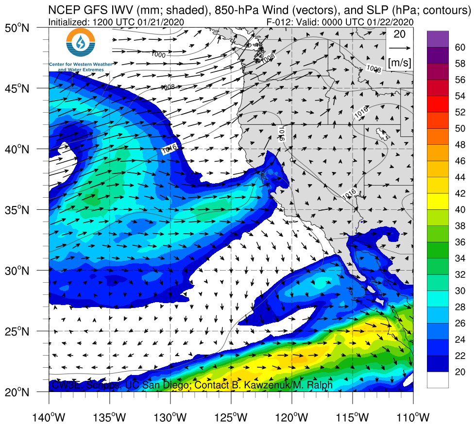
A weak atmospheric river is forecast to make landfall over coastal Oregon today

  • The weak AR is predicted to bring AR 1 conditions to several locations along the Washington and Oregon coasts
  • The AR is forecast to weaken and propagate southward impacting Northern California Wednesday evening into Thursday
  • While the moisture content associated with this storm is forecast to be low, cold temperatures and low freezing level elevations are forecast to combine to bring as much as 3 feet of snow to locations in the Coastal and Sierra Nevada Mountains

GFS Forecast Valid:
1200 UTC 15 Jan – 0000 UTC 23 Jan 2020


Summary provided by C. Hecht, B. Kawzenuk, C. Castellano, & F. M. Ralph; 15 January 2020

Forecast Informed Reservoir Operations Town Hall Held at the American Meteorological Society 100th Annual Meeting

Forecast Informed Reservoir Operations Town Hall Held at the American Meteorological Society 100th Annual Meeting

January 14, 2020

CW3E Director F. Martin Ralph organized and facilitated a Town Hall at the 100th Annual American Meteorological Society (AMS) meeting in Boston on January 14, 2020. The Town Hall presented a working definition of Forecast Informed Reservoir Operations to be included in the AMS Glossary of Meteorology and invited the community’s feedback. Panelists included Dave Curtis of West Consultants, Jeff Zimmerman of the National Weather Service Western Region, and Cary Talbot of the US Army Engineer Research and Development Center. Each discussed the importance of Forecast Informed Reservoir Operations for western United States water management resiliency from their different perspectives. The working definition, as presented at the Town Hall, is:

Forecast-informed reservoir operations (FIRO) is a reservoir-operations strategy that uses enhanced monitoring and improved weather and water forecasts to inform decision making to selectively retain or release water from reservoirs to optimize water supply reliability and environmental co-benefits and to enhance flood-risk reduction.

The many helpful comments and suggestions brought up during the panel discussion will be carefully considered by three FIRO Steering Committees and before it is finalized for submission to the Glossary.

A recording of the Town Hall can be found here.


FIRO Town Hall during Cary Talbot’s presentation. At table from left: Chad Hecht, CW3E Staff Researcher coordinating the A/V; CW3E Director Marty Ralph; Dave Curtis of West Consultants; and Jeff Zimmerman of National Weather Service Western Region..

CW3E Publication Notice: Ridging Associated with Drought Across the Western and Southwestern United States: Characteristics, Trends, and Predictability Sources

CW3E Publication Notice

Ridging Associated with Drought Across the Western and Southwestern United States: Characteristics, Trends, and Predictability Sources

January 7, 2020

NASA Jet Propulsion Laboratory postdoctoral researcher Dr. Peter B. Gibson, along with co-authors Dr. Duane E. Waliser (NASA JPL), Dr. Bin Guan (UCLA), CW3E scientist Dr. Mike DeFlorio, CW3E Director Dr. F. Martin Ralph, and Dr. Daniel Swain (UCLA/NCAR), recently published an article in Journal of Climate titled “Ridging Associated with Drought Across the Western and Southwestern United States: Characteristics, Trends, and Predictability Sources”.

This research is an important element of the ongoing partnership between JPL and CW3E. It directly supports the California Department of Water Resources (DWR) goal to improve subseasonal-to-seasonal predictability of precipitation (including atmospheric river events). This research is part of a major effort to develop near-real time subseasonal ridging outlooks to help predict precipitation, or the absence thereof, out to 6-week lead time. Improving sub-seasonal to seasonal forecasting is a major priority in CW3E’s Strategic Plan.

The specific purpose of the recently published study is to identify “wintertime ridging” events that are associated with drought conditions over the western and southwestern United States. Ridging events are defined as periods of time when mid-atmospheric high-pressure anomalies persist near the western U.S. coast and alter pathways for moisture to reach the western U.S. The remote drivers of these anomalies and their precursors are not well understood but they affect the likelihood of precipitation occurring over a given region. This work also examines the relationship of each ridge type with the El Niño-Southern Oscillation (ENSO) and other modes of climate variability. For example, a key question that this research aims to answer is: how does the presence of an El Niño event effect the likelihood of a ridge occurring near the western U.S. coast? Answering this and other questions about ridging processes will provide insights that will help predict the probability of droughts with longer lead times that are needed to better prepare for such events.

Based on this analysis, three dominant ridge types that are associated with drought over the western U.S. are identified (Fig. 1) – the “North” type (40°-55°N; 225°-250°E), the “South” type (28°-40°N; 235°-255°E), and the “West” type (28°-40°N; 210°-235°E). These key regions are used to “track” the centroid locations of ridges in operational weather models.

Figure 1: (a) First 4 EOF loadings corresponding to a combined EOF of daily precipitation anomalies over land over Western/Southwestern U.S. (shading) and Z500 anomalies (contours), see Section 2.2 for further details. The EOF domain panel details the regions used in the combined EOF analysis for Z500 (light-blue shading) and precipitation over the Western/Southwestern U.S. (blue shading). (b) Details of the ridge detection algorithm used in this study, showing an example on a given day from MERRA-2 reanalysis. The 3 labelled boxes (N, S, W) are related to EOFs as follows: N-ridge box from EOF1 (40°-55°N; 225°-250°E), S-ridge box from EOF2 and EOF4 (28°-40°N; 235°-255°E) and W-ridge box from EOF3 (28°-40°N; 210°-235°E). Contours show the daily Z500 anomalies at 50m intervals while the grey shaded regions indicate individual ridge objects (>50m threshold). The red circle in Figure 1b shows the ridge centroid for the date given, while smaller magenta crosses show the ridge centroid on the previous 2 days. From Gibson et al. 2020 (Figure 1).

Our stakeholders at California DWR, along with many other end users in the applications community, are interested in obtaining better forecasts of precipitation at S2S lead times over the Western U.S. to improve water resource management. Accordingly, the relationship of each ridge type to various modes of climate variability is shown below in Figure 2. These modes of variability impact regional weather at S2S lead times, primarily through atmospheric teleconnection patterns (i.e. regional changes in large-scale circulation driven by remote forcing weeks to months in advance).

Figure 2: Pearson correlations between monthly ridge frequency anomalies and various remote drivers/modes of variability (x-axis): the Arctic Oscillation (AO), sea ice variability over the Bering/Chukchi region (BC) and the Barents/Kara region (BK), the Pacific meridional mode (PMM), SSTs in the Western Pacific (SST WP), the Nino4 index, the Nino3.4 index, and the equatorial Southern Oscillation Index (SOI EQ.). Panel (a) shows correlations across all months October to March, while panel (b) shows correlations across January to March. P-values < 0.05 are indicated by open circles and p-values < 0.01 are indicated by filled circles. The time period is 1950-2014 with ridge types generated from 20CRV2c reanalysis. From Gibson et al. 2020 (Figure 8).

During JFM (January-February-March), several moderate-strength correlations are evident: e.g., the North Ridge type and the Pacific Meridional Mode, the West Ridge type and Western Pacific SST, and the West Ridge type and the Nińo-4 index. These simple statistical relationships will help inform future research in terms of the selection of candidate predictor variables when developing empirical S2S precipitation forecast models.

This work has introduced an objective ridge detection algorithm and defines three dominant ridge types that strongly impact precipitation and AR deficits over the Western/Southwestern U.S. region. Ongoing work between JPL/CW3E is focusing on evaluating the representation of each ridge type in operational S2S hindcast systems, which will additionally help in guiding end user interpretation of subseasonal ridging forecasts hosted on the CW3E website.

Gibson, P.B., D.E. Waliser, B. Guan, M.J. DeFlorio, F.M. Ralph, and D.L. Swain (2020): Ridging associated with drought across the Western and Southwestern United States: characteristics, trends and predictability sources. J. Climate, (In Press), https://doi.org/10.1175/JCLI-D-19-0439.1.

CW3E Publication Notice: A Case Study of the Physical Processes Associated with the Atmospheric River Initial Condition Sensitivity from an Adjoint Model

CW3E Publication Notice

A Case Study of the Physical Processes Associated with the Atmospheric River Initial Condition Sensitivity from an Adjoint Model

January 6, 2020

CW3E PhD Candidate Reuben Demirdjian, alongside coauthors including Naval Research Laboratory collaborators Jim Doyle and Carolyn Reynolds, Scripps collaborator Joel Norris, CW3E Postdoctoral Scholar Allison Michaelis, and CW3E Director F. Martin Ralph, published a paper in the Journal of Atmospheric Sciences titled “A Case Study of the Physical Processes Associated with the Atmospheric River Initial Condition Sensitivity from an Adjoint Model”. This work is a part of CW3E’s ongoing effort to understand and improve the predictions of atmospheric rivers (AR) and their impacts on public safety and water management, supporting local water agencies, California Department of Water Resources, NOAA and the U.S. Army Corps of Engineers. This research advances the understanding of why errors in weather forecast model representation of AR conditions offshore can lead to errors in AR landfall conditions and associated precipitation. It is through a dynamical feedback process that connects errors in water vapor and winds in an AR offshore at the start of a forecast, to precipitation upon landfall. The results contribute to Atmospheric River Reconnaissance, which collects unique airborne observations offshore in and around ARs prior to their landfall, for assimilation in global weather prediction models and in CW3E’s West-WRF regional weather model.

This paper performs an analysis of a strong landfalling atmospheric river which compares the evolution of a control simulation with that of an adjoint-derived perturbed simulation using the Coupled Ocean/Atmosphere Mesoscale Prediction System (COAMPS). The water vapor transport is found to be substantially enhanced at the California coast in the perturbed simulation during the time of peak precipitation, demonstrating a strengthened role of the orographic precipitation forcing. Similarly, moisture convergence and vertical velocities derived from the transverse circulation are found to be substantially enhanced during the time of peak precipitation, also demonstrating a strengthened role of the dynamic component of the precipitation. Importantly, both components of precipitation are associated with enhanced latent heating by which: i) a stronger diabatically driven low-level potential vorticity anomaly strengthens the low-level wind (and thereby the orographic precipitation forcing), and ii) greater moist diabatic forcing enhances the Sawyer-Eliassen transverse circulation and thereby increases ascent and dynamic precipitation (Fig 1).

Figure 1: (Figure 12 from Demirdjian et al., 2019) A pseudo-4D schematic illustrating the evolution of cross sections in an AR relative reference frame. The IVT values of the AR are shown in the yellow to red shading (small to large values respectively). The cross sections show potential temperature (gray contours), the LPF moisture perturbation (black contours), and the transverse circulation in plane of the cross section in the black arrows with the strength indicated by the length and arrow thickness.

Demirdjian, R., Doyle, J.D., Reynolds, C.A. Norris, J.A., Michaelis, A.C., Ralph, F.M., 2019: A Case Study of the Physical Processes Associated with the Atmospheric River Initial Condition Sensitivity from an Adjoint Model. Journal of the Atmospheric Sciences, 0, DOI 10.1175/JAS-D-19-0155.1.

CW3E Publication Notice: Training the Next Generation of Researchers in the Science and Application of Atmospheric Rivers

CW3E Publication Notice

Training the Next Generation of Researchers in the Science and Application of Atmospheric Rivers

January 3, 2020

Dr. Anna Wilson, Field Research Manager of the Center for Western Weather and Water Extremes (CW3E), recently published a Meeting Summary in the Bulletin of the American Meteorological Society on the 2019 Atmospheric Rivers Colloquium Summer School. Co-authors include all members of the International Steering Committee, and CW3E graduate student Will Chapman and Director Dr. Marty Ralph.

CW3E is an interdisciplinary hub for stakeholders and scientists interested in collaborative research on atmospheric rivers (ARs) and their impacts. The International Atmospheric Rivers Conference (IARC), which has been held every two years since 2016, is one of several events organized by CW3E designed to foster these collaborations.

At IARC 2018, the idea was hatched to bring students together with AR experts. This activity aligns directly with CW3E’s core commitment to integrating research with education. The Atmospheric Rivers Colloquium Summer School included 31 students and 19 instructors, and was held in June-July 2019 at the Scripps Institution of Oceanography, University of California San Diego. It was sponsored and hosted by CW3E, with support from the U.S. Army Corps of Engineers’ Atmospheric Rivers / Forecast-Informed Reservoir Operations Program.

The overarching goal of the Colloquium was to provide the next generation of atmospheric scientists with an in-depth look at cutting edge techniques in understanding, monitoring, and predicting ARs and their associated high-impact weather. To achieve this goal, the Colloquium brought together a diverse group of early and mid-career researchers, senior scientists, and practitioners who use AR information. The attendees ranged from high school to Ph.D. graduates from 25 different institutions in 11 countries (Fig. 1). The lectures were given by leading atmospheric scientists and were based on the soon to be released AR monograph. In addition to daily lectures, the agenda included time for the students to interact with the researchers and gain hands-on experience.

For more details on the Colloquium, please see the following links:

/the-ar-colloquium-kicks-off/

/week-2-of-the-ar-colloquium-is-underway/

Figure 1: (a) Peer review journal articles referring to the topic of ARs published per year. The 2019 count represents January – August. Papers were counted via Google Scholar. (b) Locations (asterisks and circles) of Colloquium Summer School participants by education level, instructors, and study locations (red squares) of ARs from Fig. 1a (adapted from Fig. 1 of Wilson et al. 2019).

Wilson, A. M., W. Chapman, A. Payne, A. M. Ramos, C. Boehm, D. Campos, J. Cordeira, R. Garreaud, I. V. Gorodetskaya, J. J. Rutz, C. Viceto, and F. M. Ralph, 2019: Training the Next Generation of Researchers in the Science and Application of Atmospheric Rivers. Bull. Amer. Meteor. Soc., https://doi.org/10.1175/BAMS-D-19-0311.1..

AR Colloquium Summer School International Steering Committee Members:

Christoph Boehm (student member), University of Cologne

Diego Campos (student member), University of Chile; Dirección Meteorológica de Chile

Will Chapman (student member), Center for Western Weather and Water Extremes, UC San Diego

Dr. Jason Cordeira, Plymouth State University

Dr. Rene Garreaud, University of Chile

Dr. Irina Gorodetskaya, University of Aveiro

Dr. Ashley Payne, University of Michigan

Dr. F. Martin Ralph, Center for Western Weather and Water Extremes, UC San Diego

Dr. Alexandre Ramos, University of Lisbon

Dr. Jonathan J. Rutz, NOAA National Weather Service Western Region

Carolina Viceto (student member), University of Aveiro

Dr. Anna M. Wilson, Center for Western Weather and Water Extremes, UC San Diego
CW3E Event Summary: 22-27 December 2019

CW3E Event Summary: 22-27 December 2019

December 31, 2019

Click here for a pdf of this information.

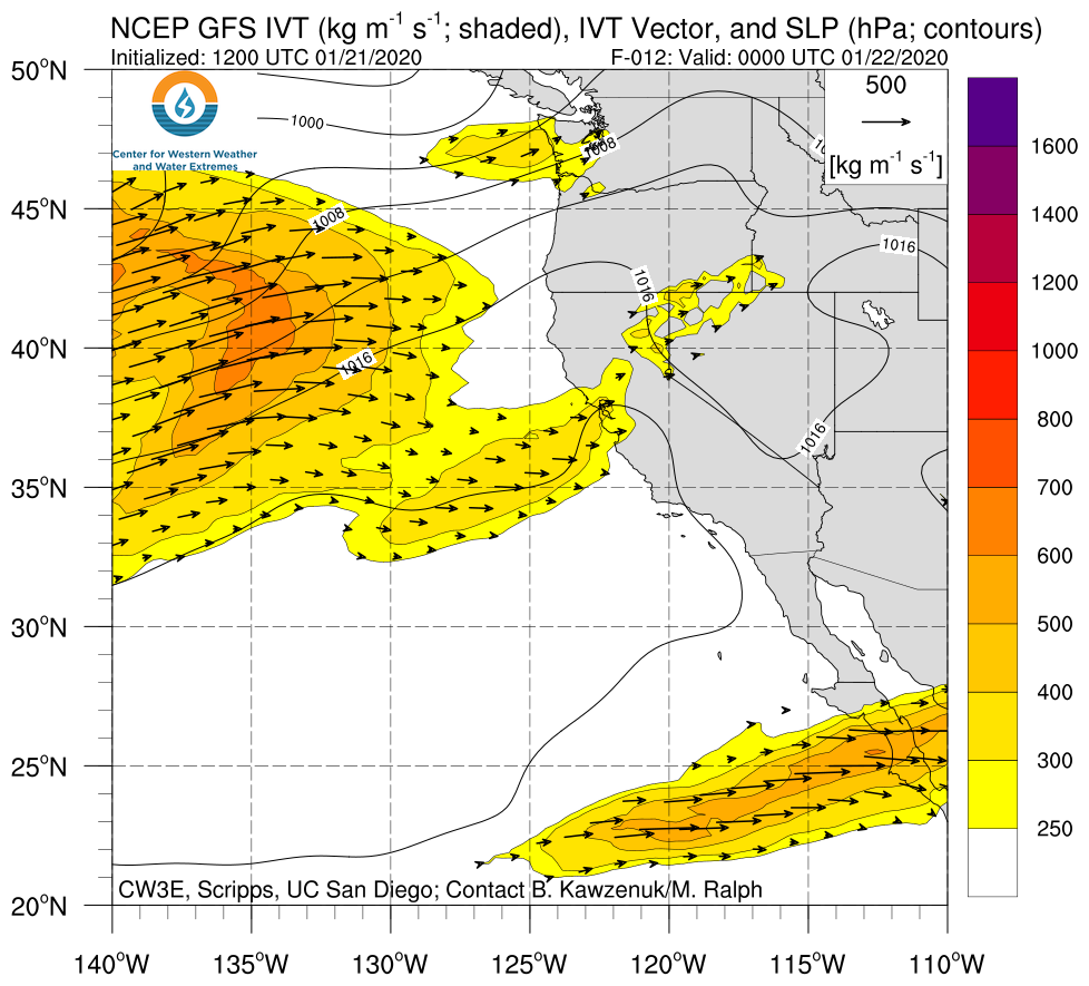
Multiple storms bring heavy rainfall and mountain snowfall to Southern California

  • Two separate systems affected Southern California on 22–23 Dec and 25–27 Dec
  • Some parts of Southern California received more than 3 inches of total rainfall
  • The second storm produced 1–3 feet of snow over the higher elevations of the Transverse Ranges


Summary provided by C. Castellano; 31 December 2019

CW3E Event Summary: 19-22 December 2019

CW3E Event Summary: 19-22 December 2019

December 29, 2019

Click here for a pdf of this information.

Landfalling AR brings heavy rainfall and mountain snowfall to the Pacific Northwest

  • AR conditions persisted for 24–48 hours over coastal and interior sections of the Pacific Northwest
  • Some locations along the coast of Oregon and Northern California experienced AR conditions for more than 48 hours
  • Storm total precipitation exceeded 5 inches over much of western Oregon and western Washington
  • More than 2 feet of snow fell in the highest elevations of the North Cascades
  • Click IVT or IWV image to see loop of GFS analyses

    Valid 1200 UTC 18 December – 1200 UTC 22 December 2019


    Summary provided by C. Castellano; 29 December 2019

CW3E Graduate Student Speaks at Instituto Dom Luiz in Portugal

CW3E Graduate Student Speaks at Instituto Dom Luiz in Portugal

December 23, 2019

In early December, Tashiana Osborne (CW3E graduate student) was invited to speak at Instituto Dom Luiz (IDL) in Lisbon, Portugal. Dr. Alexandre Ramos, CW3E collaborator and IDL researcher, hosted Osborne during a Geophysical Science seminar on campus. Osborne presented background information on atmospheric rivers and recent CW3E research efforts. She also described science policy-related experiences as a Scripps/Moravian College delegate for the most recent United Nations climate change conference (COP25 – more about Osborne’s experience here).

Similar to CW3E, IDL “aims to be relevant not only in fundamental Earth System research, but also in applications and technologies that relate science with the main 21st century societal concerns: forecasting and adapting to climate change and to other major natural hazards, and establishing an environmentally sustainable supply of raw materials, water and energy.”

Ramos served as a co-facilitator and mentor for recent International Atmospheric Rivers Colloquia (IARC). He has published relevant research involving tracking and detecting atmospheric rivers, and understanding atmospheric rivers impacting the Iberian Peninsula and South Africa (view links to Ramos’ work here).


Osborne sharing with a group of IDL researchers and students in Lisbon (PC: IDL).

CW3E Participates in Thriving Earth Exchange Project

CW3E Participates in Thriving Earth Exchange Project

December 19, 2019

CW3E Field Researcher, Carly Ellis, was invited to speak to AGU Thriving Earth Exchange’s new Fellows on December 7 during their two-day fellowship workshop in San Francisco. Thriving Earth Exchange is a program that connects community leaders to scientists who can work together to solve local challenges related to natural resources, climate change, and natural hazards. Carly has been working with Thriving Earth Exchange on a community-based project in San Diego for about ten months. She is one of two Science Liaisons for the Chollas Creek project, in which 4th and 5th grade students are assessing long-term trash deposition in Chollas Creek. The kids plan to present their findings to the public, as well as local council members on Earth Day 2020. For more information on the Chollas Creek project, please go to https://thrivingearthexchange.org/project/sandiego-ca/.

Carly helps students from a local elementary school collect data along a 100 ft section of Chollas Creek

CW3E at AGU 2019

CW3E at AGU 2019

December 18, 2019

CW3E participated in the recent 2019 American Geophysical Union Fall Meeting held in San Francisco, CA from 9-13 December. Graduate students, postdocs, and staff convened sessions, spoke, and presented posters. The list below covers CW3E personnel activities. Links include abstracts, as well as audio presentations (when available) and other supplementary materials.

Astitha M., L.D. Monache, and F. Cannon. A34C- Extreme Weather Events: Forecast Skill, Uncertainty Quantification, and Impact Modeling I

Astitha M., L.D. Monache, and F. Cannon. A31O – Extreme Weather Events: Forecast Skill, Uncertainty Quantification, and Impact Modeling II Posters

Ban Z., T. Das, D.R. Cayan, M. Xiao, and D.P. Lettenmaier. H23J-2036- Understanding the Role of Asymmetrical Warming on Streamflow Changes in the Western U.S. Using a Multi-model Approach

Brandt T., F. Cannon, J. Dozier. H33P-2239- Assessing WRF’s Seasonal Quantitative Precipitation Estimates (QPE) in California’s Sierra Nevada Using the Airborne Snow Observatory

Borsa A.A., S. Adusumilli, W. Neely, and F.M. Ralph. H33O-2228- Atmospheric river precipitation drives rapid terrestrial water storage variability in the western United States

Candido S., A. Singh, and L.D. Monache. A21O-2769- Distilling an Analog Ensemble into a Deep Neural Network

Cannon F., R.R. Weihs, L. Isaac, and L.D. Monache. H31D-07- An Ensemble-Based Evaluation of WRF Precipitation Forecast Uncertainty in California Watersheds

Cao B., J.S. Haase, M.J. Alexander, M. Bramberger, M.J. Murphy, and F.M. Ralph. SA23B-3127- Investigation of inertia gravity waves observed by dropsonde and airborne Radio Occultation during an Atmosphere River event in the northeast Pacific

Cao Q., M.J. Deflorio, F.M. Ralph, and D.P. Lettenmaier. H13F-03- Evaluation of the subseasonal forecast skill of AR-related flooding along the coastal Western U.S.

Cayan D. R., J.P. Goodrich, M. Buhler, and D. Dulen. GC44B-03 – Cold Air Pooling during Summer Heat Waves in California’s Sierra Nevada

Cifelli R., A.M. Wilson, A. Dufour, T.W. Parzybok, M.D. Dettinger, J.A. Vano, F. Munoz-Arriola, and K.A. Miller. PA34A-07- Toward Greater Resilient Water Infrastructure to Future Hydrometeorological and Climate Extremes: Lessons from Oroville Dam and Hurricane Harvey

Corringham T., F.M. Ralph, A. Gershunov, D.R. Cayan, and C.A. Talbot. H14G-06 – A scale of atmospheric river intensity captures the economic impacts of flooding in the western United States

Deflorio M., D.E. Waliser, F. M.Ralph, L.D. Monache, P. Gibson, B. Guan, A. Goodman, Z. Zhang, A. Gershunov, T. Shulgina, K. Guirguis, S. Asharaf, A. Subramanian, F. Vitart, H. Lin, and A. Kumar. H31G-04- Subseasonal-to-Seasonal (S2S) Prediction of Atmospheric Rivers and Precipitation over the Western United States

Delaney C., M. Konieczki, R. Hartman, J. Mendoza, J. Jasperse, F.M. Ralph, and C. Talbot. H13S-2031- A Risk-Based Decision Support System for Flood Operations of Lake Mendocino in Water Year 2019

Dettinger M.D., H14E-02- Drought Indicators for the Western US with Climate Change in Mind

Fish M.A., A.M. Wilson, J. Done, and F.M. Ralph. GC52A-01- Large-scale drivers of connected atmospheric rivers along the US West Coast

Gibson P.B., D.E. Waliser, B. Guan, M. DeFlorio, F.M. Ralph, and D.L. Swain. A24A-04- Ridging associated with drought across the Western United States: S2S predictability sources and model skill

Guan B., D.E. Waliser, and F.M. Ralph. A34F-04- Lightning Characteristics Associated with Atmospheric Rivers Affecting the Continental US Using the GOES-16/17 Geostationary Lightning Mappers

Harpold A.A., P.D. Brooks, M. Kohler, J. Sturtevant, B. Gordon, and M.D. Dettinger. H11J-1630- How Ready Is The Hydrologic Sciences For the Loss of Seasonal Snowpacks (And What Can Be Done)?

Katz L.J., A.A. Harpold, M.D. Dettinger, S.A. Drake, K.S. Jennings, and S. Rajagopal. H51P-1700- Catch or Release? Sensitivity of Extreme Rain-on-Snow Responses to Snowpack Mass and Energy Balances in California’s Northern Sierra Nevada, USA

Knowles N., D.R. Cayan, C. Cronkite-Ratcliff, M.D. Dettinger, A.L. Flint, L.E. Flint, T. Fregoso, J.J. Helly, B.E. Jaffe, H. Kernkamp, L.V. Lucas, R. Martyr-Koller, T. Morgan-King, D.W. Pierce, D. Roelvink, D.H. Schoellhamer, M.A. Stern, A. van Dam, S. van der Pijl, M. Van der Wegen, J. Vroom, and S.A. Wright. H52D-03- Climate-to-ecosystem integrated modeling in the San Francisco Bay-Delta estuary: An overview of the CASCaDE project (Part 1—Modeling of physical processes)

Lamjiri M.A., F.M. Ralph, and M.D. Dettinger. A43O-3034- Recent Changes in United States Extreme Precipitation as Indicated by Excursions on the R-CAT Scale

Mascioli N., A.T. Evan, and F.M. Ralph. A34B-05- Influence of dust on landfalling atmospheric rivers in an idealized framework

Nguyen P., E.J. Shearer, M. Ombadi, V.A. Gorooh, K. Hsu, S. Sorooshian, W.S. Logan IV, and F.M. Ralph. H22D-06PDIR- (PERSIANN Dynamic Infrared – Rain rate) model for high-resolution, real-time satellite precipitation estimation

Oakley N., F. Cannon, E. Boldt, J.L. Dumas, and F.M. Ralph. H11N-1708- Origins and Variability of Extreme Precipitation in the Santa Ynez River Basin of Southern California

Osborne T. C., J.R. Norris, A.M. Wilson, B. Henn, B. Hatchett, and F.M. Ralph. A53L-3074- Extreme Changes in Atmospheric Snow Level Observed by FM-CW Snow Level Radars During California Storms

Payne A.E., C.A. Shields, J.J. Rutz, L.R. Leung, T.A. O’Brien, F.M. Ralph, and M.F. Wehner. A41E-03- Atmospheric Rivers in a Changing Climate: An Overview from the Second Phase of the Atmospheric River Tracking Method Intercomparison Project (ARTMIP)

Pierce D.W. and D.R. Cayan. A51Q-2839- Downscaling IPCC Scenarios to the Hourly Level: Projected Changes in Energy Demand and Chill Hours in California

Reynolds C.A., R. Stone, J.D. Doyle, N.L. Baker, R. Langland, F.M. Ralph, D. Lavers, and P. Papin. A31M-2880- Experiments using Atmospheric River Reconnaissance Dropsondes

Ryoo J., S. Chiao, R.J. Spackman, L.T. Iraci, F.M. Ralph, A. Martin, J.E. Marrero, E.L Yates, R.M. Dole, T.V. Bui, J.M. Dean-Day, and C.S. Chang. A51O-2868- Formation of Terrain Trapped Airflows in Northern California during Atmospheric Rivers and its impact on Precipitation: A Case Study using Measurements and Model

Sturtevant J., M.D. Dettinger, S.A. McAfee, S. Rajagopal, and A.A. Harpold. H33P-2246- Improving Regression-Based Water Supply Forecasts following Snow Droughts in the Western U.S.

Sumargo E., R.R. Weihs, and A.M. Wilson. H51U-1803- Profiling of Soil Moisture Variability and Its Role in Rainfall-Runoff Generation in Northern California’s Russian River Watershed

Wilson, A.M. EP53D-16 – Rivers in the Sky – Why I Study the Earth’s Atmospheric Processes (Invited)

Wilson, A.M., F. M. Ralph, J. Jasperse, and C.A. Talbot. PA34B-11 – Exploring Novel Strategies to Enhance Use of Existing Water Management Infrastructure: Collecting Unique Observations with Local Partners (Invited)