CW3E AR Update: 9 March 2020 Outlook

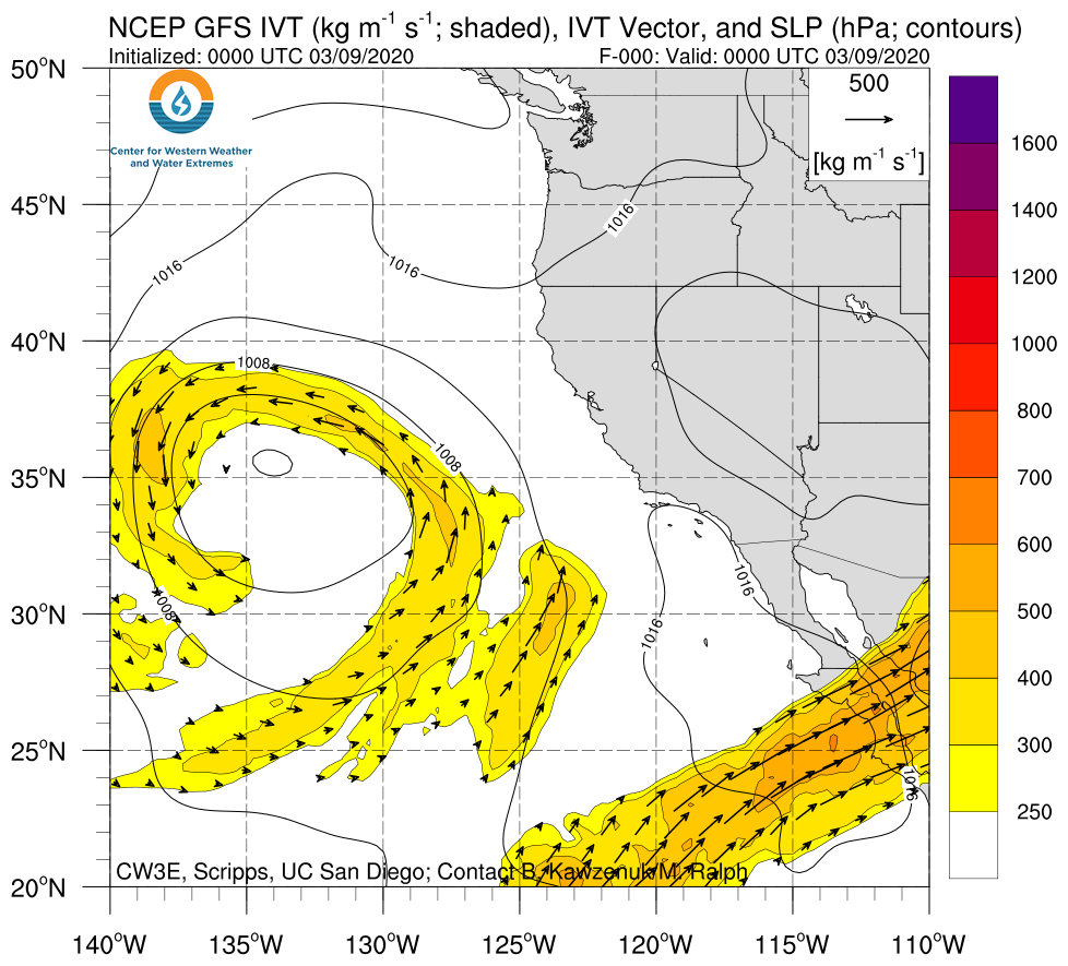
CW3E AR Update: 9 March 2020 Outlook

March 9, 2020

Click here for a pdf of this information.

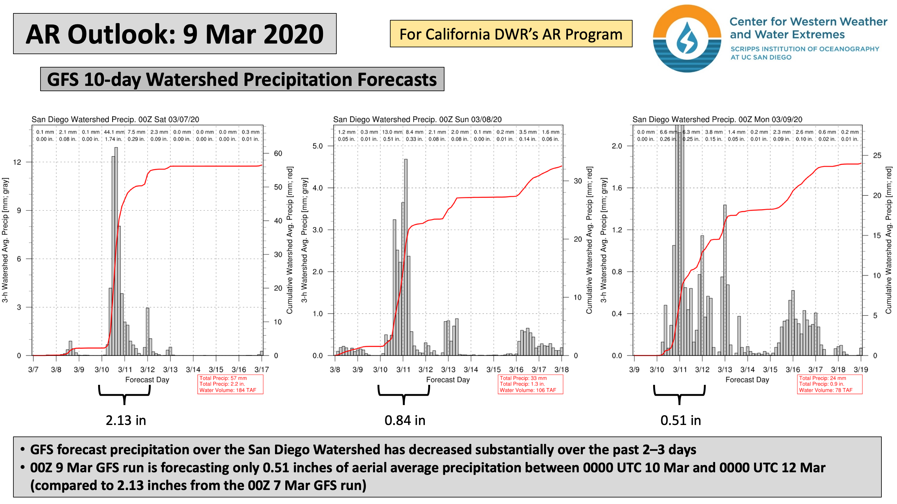
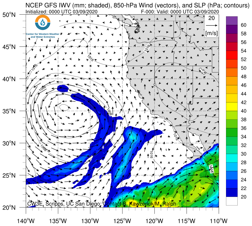
A cutoff low and landfalling AR will bring moderate-to-heavy rainfall to portions of the southwestern U.S.

  • The interaction between a cutoff low off the California coast and tropical moisture over the Eastern Pacific will result in a landfalling atmospheric river (AR) over Baja California, Southern California, and Southern Arizona
  • Some areas in southern Arizona may experience 48 hours of AR conditions
  • The highest precipitation amounts (1–3 inches) are expected in Southern California and the Lower Colorado River Basin
  • More than 3 inches of precipitation are possible over the Transverse Ranges, Peninsular Ranges, and higher terrain in central Arizona

Click IVT or IWV image to see loop of GFS analyses/forecasts

Valid 0000 UTC 9 March – 0000 UTC 14 March 2020


Summary provided by C. Castellano, C. Hecht, F. M. Ralph, and A. Wilson; 9 March 2020

*Outlook products are considered experimental

CW3E AR Update: 6 March 2020 Outlook

CW3E AR Update: 6 March 2020 Outlook

March 6, 2020

Click here for a pdf of this information.

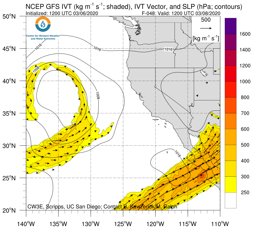
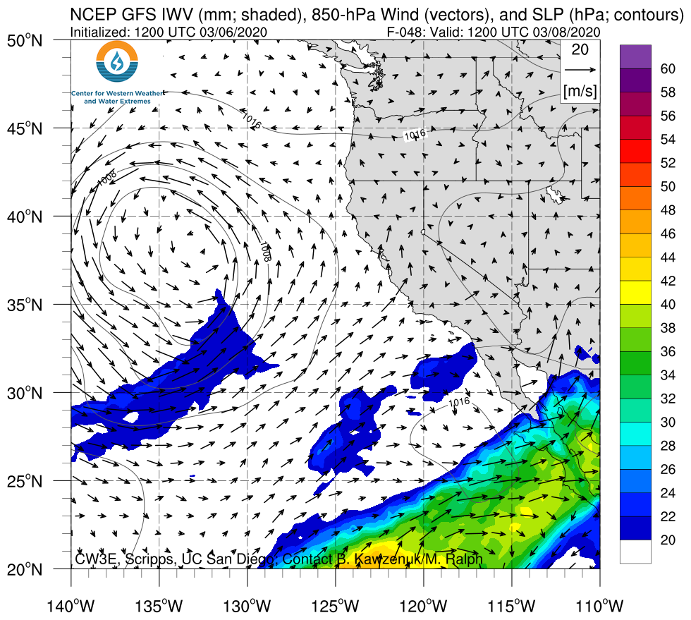
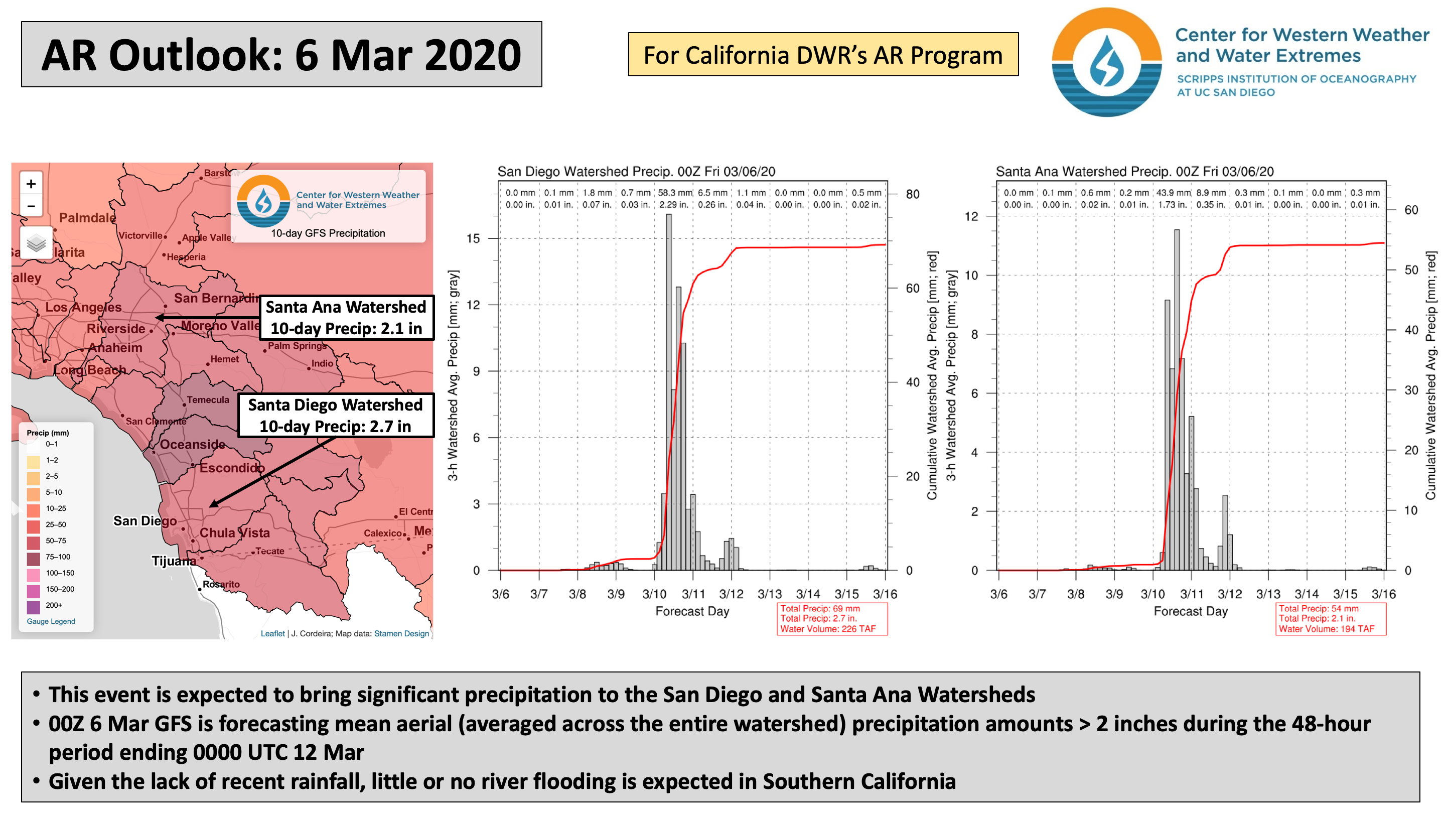
A cutoff low and landfalling AR is forecast to bring moderate-to-heavy rainfall to portions of the southwestern U.S.

  • The interaction between a cutoff low off the California coast and tropical moisture over the Eastern Pacific is expected to result in a landfalling atmospheric river (AR) over Southern California and Arizona early next week
  • Some areas in coastal Southern California may experience at least AR2 conditions
  • The highest precipitation amounts are expected in Southern California, with 1–2 inches forecast over coastal and inland valley areas, and more than 2.5 inches possible over the Transverse and Peninsular Ranges

Click IVT or IWV image to see loop of GFS analyses/forecasts

Valid 1200 UTC 8 March – 0000 UTC 12 March 2020


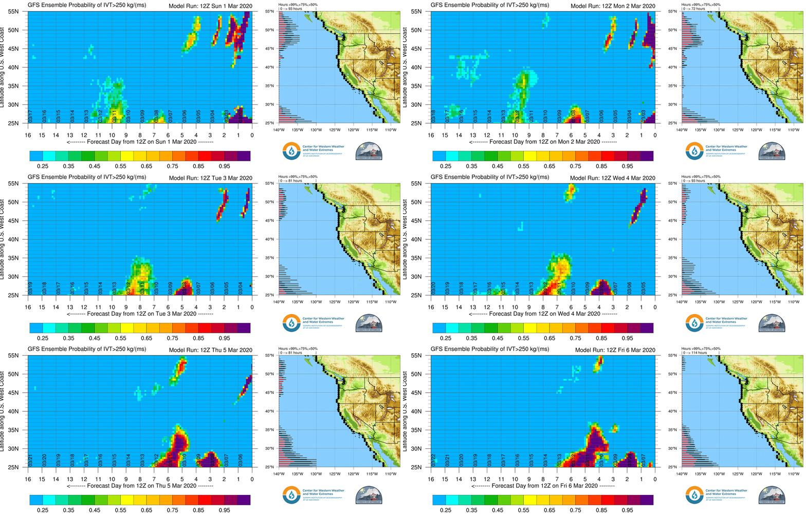
GEFS AR Landfall Probabilities: dProg/dt

Initialization Period: 1200 UTC 1 March – 1200 UTC 6 March 2020

  • Confidence in the probability of AR conditions along the Southern California coast has increased substantially over the past 5 days
  • As the loop demonstrates, run-to-run differences in forecast AR landfall probability were quite large until ~ 12Z 5 Mar
  • High uncertainty in AR conditions was driven primarily by uncertainty in the evolution of a cutoff low that will form over the Northeast Pacific Ocean during the next 48 hours


Summary provided by C. Castellano, L. Delle Monache, B. Kawzenuk, and F. M. Ralph; 6 March 2020

*Outlook products are considered experimental

CW3E Event Summary: 21-23 February 2020

CW3E Event Summary: 21-23 February 2020

February 25, 2020

Click here for a pdf of this information.

Cutoff low and landfalling AR bring heavy rainfall and mountain snowfall to southwestern U.S.

  • Southern Arizona experienced weak-to-moderate AR conditions for more than 24 hours [AR1/AR2 based on the Ralph et al. (2019) AR Scale]
  • Some locations in central AZ received more than 2 inches of total precipitation from this event
  • Significant snowfall (> 8 inches) also occurred over the higher terrain in south-central UT and central CO

MIMIC-TPW2 Total Precipitable Water

Valid 1200 UTC 20 February – 1200 UTC 23 February

Images from CIMSS/Univ. of Wisconsin

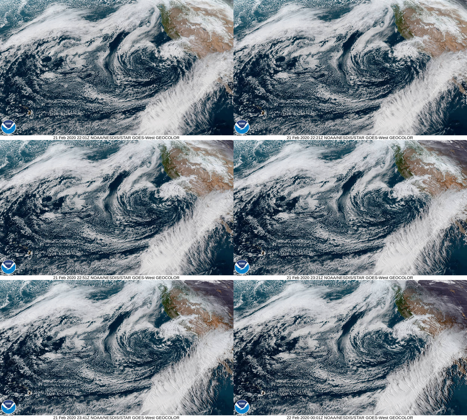
GOES-West GeoColor

Valid 2201 UTC 21 February – 0001 UTC 22 February

Images from NOAA/NESDIS/STAR and CIRA/NOAA


Summary provided by C. Castellano, C. Hecht, B. Kawzenuk, N. Oakley, and F. M. Ralph; 25 February 2020

CW3E Fosters Closer Connections at the Head of the Yampa River in Steamboat Springs, CO

CW3E Fosters Closer Connections at the Head of the Yampa River in Steamboat Springs, CO

February 24, 2020

Early this February, CW3E Ph.D. students Kara Voss and Mike Sierks visited Steamboat Springs, Colorado to learn more about the headwaters of the Colorado River, meet with key stakeholders in the area, and share information about the connections between the work of CW3E and water issues in the region. This coming June CW3E is set to co-host the annual Yampa Basin Rendezvous (YBR) for the third consecutive year. The YBR is an annual conference held at Colorado Mountain College where members of the Steamboat community, including commercial, agricultural and recreational users of water from the Yampa River, gather with other organizations including CW3E to learn and share information about how to use climate and meteorological information to improve the resilience of their community. YBR is an effort to connect graduate students, post-doctoral scholars, researchers, staff and faculty from CW3E to river basins throughout the west, to pursue the mission and goals of this new center. CW3E is based at the University of California San Diego’s (UCSD) Scripps Institution of Oceanography and is building a regional community of scientists and engineers to work on western weather and climate problems.

Two members of the YBR Steering committee — Sarah Jones, the former director of the Yampa Valley Sustainability Council and current Sustainability and Community Engagement Director for Steamboat Ski Resort, and Nathan Stewart, Professor at Colorado Mountain College, graciously hosted Kara and Mike’s visit allowing them to connect with individuals from a variety of sectors. Mike and Kara met with local water managers, the Colorado State Forest Service, Steamboat Ski Resort, and local government officials responsible for Steamboat’s climate action plan. The goal of these meetings was to learn about the different groups’ planning and operations and understand how CW3E’s expertise could overlap with their work in the future. Mike and Kara gave several guest lectures at Colorado Mountain College and at the local high school, sharing CW3E’s work with an audience of enthusiastic students, and gave Steamboat Ski Resort’s first science ‘Brown Bag’ talk discussing how changing climate has been observed to influence snowpack in the western U.S. over recent decades. Mike and Kara also met with scientists at Storm Peak Laboratory, a cloud and aerosol microphysics observing laboratory located at the top of Steamboat Ski Resort, to discuss future collaboration and research directions. Between skiing to meetings, talking about cool science, and engaging with fascinating and warm members of the Steamboat Springs community, the Ph.D. candidates expressed that they never thought a work trip could be this good!

This meeting represents a continuing connection between Steamboat Springs, home of the Yampa River (headwaters of the Colorado River), and CW3E, based in San Diego (which gets a significant amount of water via the Colorado River).

CW3E AR Update: 20 February 2020 Outlook

CW3E AR Update: 20 February 2020 Outlook

February 20, 2020

Click here for a pdf of this information.

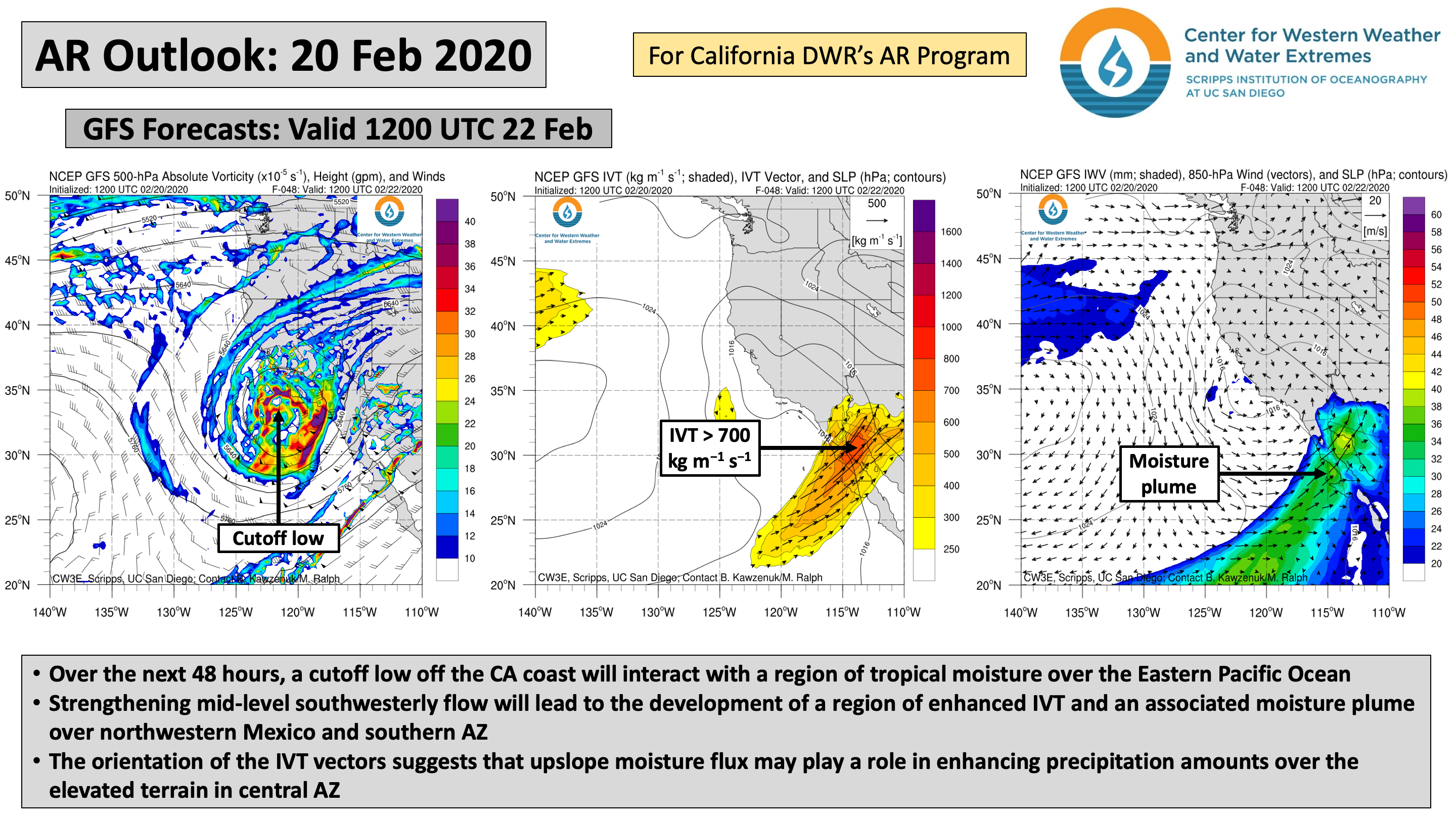
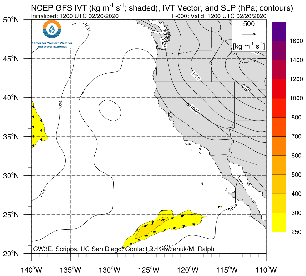
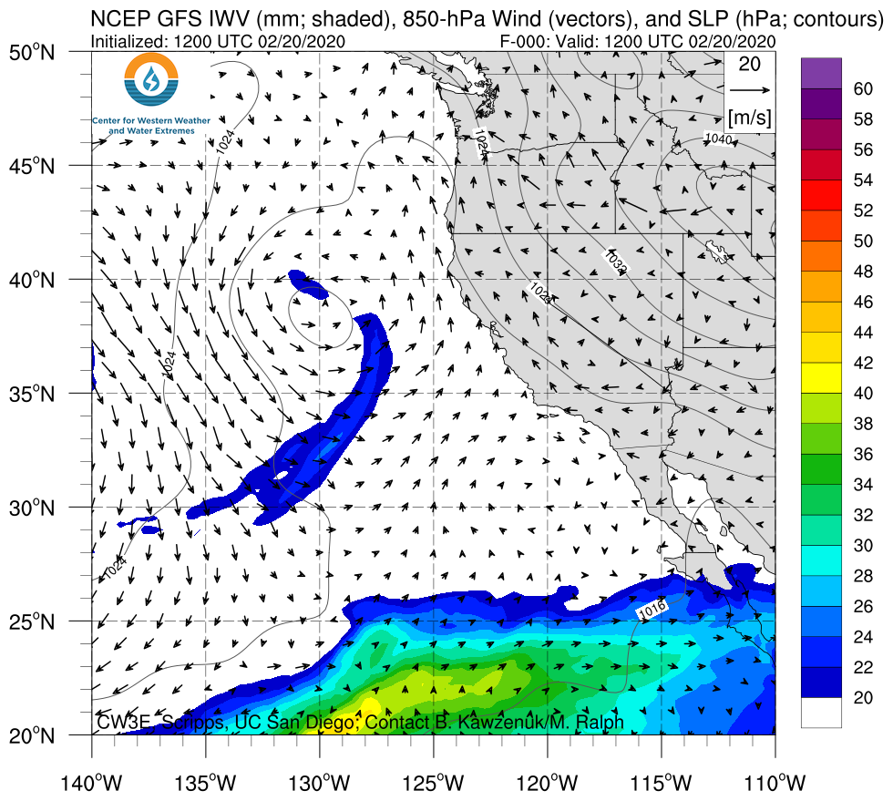
A cutoff low and landfalling AR will bring moderate-to-heavy rainfall to portions of the southwestern U.S.

  • The interaction between a cutoff low off the California coast and tropical moisture over the Eastern Pacific will result in a landfalling AR over Baja California
  • As time progresses, the AR will intensify and move northeastward across Arizona and New Mexico
  • Some areas in southern AZ are forecast to experience AR2 conditions
  • More than 0.5 inches of precipitation are forecast over portions of the southwestern U.S., with the highest amounts (> 1.5 inches) expected over the higher terrain in central and eastern AZ, as well as the San Juan Mountains in CO

Click IVT or IWV image to see loop of GFS analyses/forecasts

Valid 1200 UTC 20 February – 1200 UTC 23 February 2020


Summary provided by C. Castellano and F. M. Ralph; 20 February 2020

*Outlook products are considered experimental

CW3E Welcomes Dr. Peter Gibson

CW3E Welcomes Dr. Peter Gibson

February 20, 2020

Dr. Peter Gibson joined CW3E in February 2020. Originally from New Zealand, he earned a B.S. with a double major in Mathematics and Physical Geography from the University of Otago (2012). His MS thesis (2014), also from the University of Otago, focused on how synoptic weather types influence regional variability and reliability in New Zealand’s wind energy resource. Peter then moved to Australia to complete his doctoral thesis (2017) at the University of New South Wales, where his research focused on better understanding the large-scale drivers of Australian heatwaves in a changing climate. After completing his PhD, Peter moved further abroad to California and worked as a postdoctoral researcher at NASA’s Jet Propulsion Laboratory under supervision of Duane Waliser (2017-2020). During this time, his research focused primarily on drought and atmospheric ridging/blocking across the western United States, including examining sources of predictability and model skill on subseasonal-to-seasonal (S2S) timescales.
At CW3E, Peter will serve as a Senior Researcher on S2S projects. He will research S2S skill of operational hindcast systems in terms of probabilistic forecasts of atmospheric ridging/blocking and atmospheric rivers. Informed by these skill assessments, he will continue to develop the suite of S2S operational products for the Center. Peter will also test and implement novel machine learning approaches for longer-lead seasonal prediction of drought and atmospheric rivers.

Three Aircraft Set to Sample Atmospheric River This Afternoon

Three Aircraft Set to Sample Atmospheric River This Afternoon

February 14, 2020

As part of Atmospheric River Reconnaissance, in collaboration with the US Air Force 53rd Weather Reconnaissance Squadron and the National Oceanic and Atmospheric Administration (NOAA) Aircraft Operations Center, there will be three reconnaissance aircraft sampling an Atmospheric River over the northwest Pacific Ocean this afternoon. Flights will be centered on 0000 UTC 15 February 2020 in an effort to increase data assimilated into the global weather models. Planned flight tracks are shown below where 80 dropsondes (25 from each Air Force C-130 and 30 from the NOAA G-IV) will be released to measure temperature, humidity, pressure, and winds throughout the atmosphere. This will be the eighth intensive observing period (IOP) flown this winter as part of AR Recon, and the third with three aircraft.


Planned flight tracks of two USAF C-130 and NOAA G-IV aircraft over NCEP GFS 42-hour forecast of integrated vapor transport (kg m-1 s-1; shaded and vectors) and sea level pressure (hPa; contours) valid at 000 UTC 15 February 2020.

These data will be assimilated into the global atmospheric models in an effort to improve what has been a very uncertain forecast. Over the past several days various weather models have shown a great deal of uncertainty in forecasting the strength and timing of this AR, as well as the precipitation associated with it (more information below). Although this AR is not very strong (currently forecasted to be an AR 1 according to the AR Scale; Ralph et al. 2019, it will make landfall over the Pacific Northwest following a very wet period that resulted in the current high soil moisture, which increases the likelihood of runoff with several rivers already at an elevated stage.

NOAA G-IV taking off out of Portland International Airport on 6 February 2020 for AR Recon IOP 6 (Photo credit: Jack Parrish; NOAA).

CW3E researcher Forest Cannon practices using a survival suit as part of pre-flight protocol.


For more information about Atmospheric River Reconnaissance visit /arrecon_overview/.

For AR forecasts visit the CW3E AR forecasts webpage, and for precipitation and streamflow forecasts visit the Northwest River Forecast Center or the Weather Prediction Center.

CW3E Welcomes Marian de Orla-Barile

CW3E Welcomes Marian de Orla-Barile

February 12, 2020

Marian de Orla-Barile joined CW3E as a lab assistant in January 2020. He completed his B.S. in electrical engineering at California State University, Long Beach in 2018. While an undergraduate, Marian received funding from the NIH diversity research initiative, BUILD, to work as a student researcher where he performed water quality testing of various contaminants
within the Los Angeles River watershed to study storm drain contributions during the dry weather season.

After graduating, Marian worked as a summer intern in 2019 for CW3E with Dr. Forest Cannon on a project focused on documenting the occurrence of narrow cold-frontal rainband (NCFR) episodes within Southern California using archived NEXRAD radar imagery.

As a newly hired lab assistant, Marian’s focus is to continue to expand the work on NCFR impacts within Southern California, as well as to lead radiosonde launches in the Yuba watershed to support the objectives of the Forecast Informed Reservoir Operations program.

Marian hopes to continue to grow his knowledge base in meteorology through his work at CW3E and is excited to continue to contribute meaningful work to his home state of California.

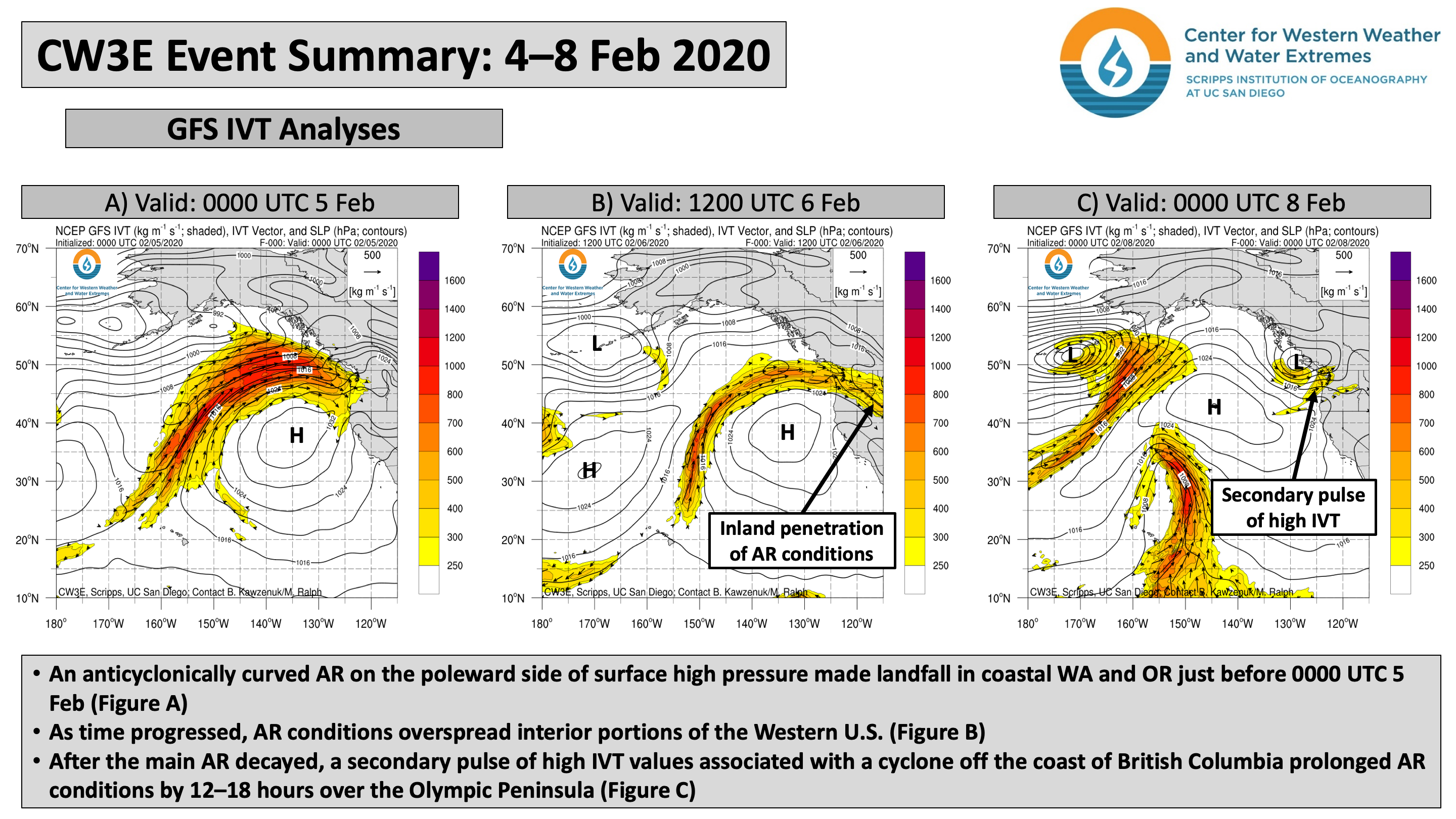
CW3E Event Summary: 4-8 February 2020

CW3E Event Summary: 4-8 February 2020

February 11, 2020

Click here for a pdf of this information.

Landfalling AR brings heavy rainfall, mountain snowfall, and flooding to the Western U.S

  • A long-duration, inland-penetrating AR impacted the Pacific Northwest and Rocky Mountains during 4–8 Feb
  • Some locations in coastal Washington experienced AR conditions for more than 72 hours
  • Total estimated 7-day precipitation between 3 Feb and 10 Feb exceeded 10 inches over the WA Cascades
  • At least 1–3 feet of snow fell over the elevated terrain in the interior Pacific Northwest and the Rocky Mountains
  • Heavy rainfall on top of saturated soils resulted in river flooding and landslides in western WA

Click IVT or IWV image to see loop of GFS analyses

Valid 0000 UTC 4 February – 1800 UTC 8 February 2020


Summary provided by C. Castellano and F. M. Ralph; 11 February 2020

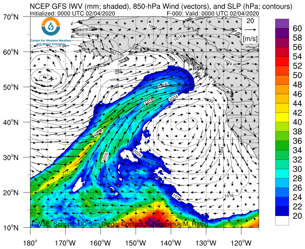
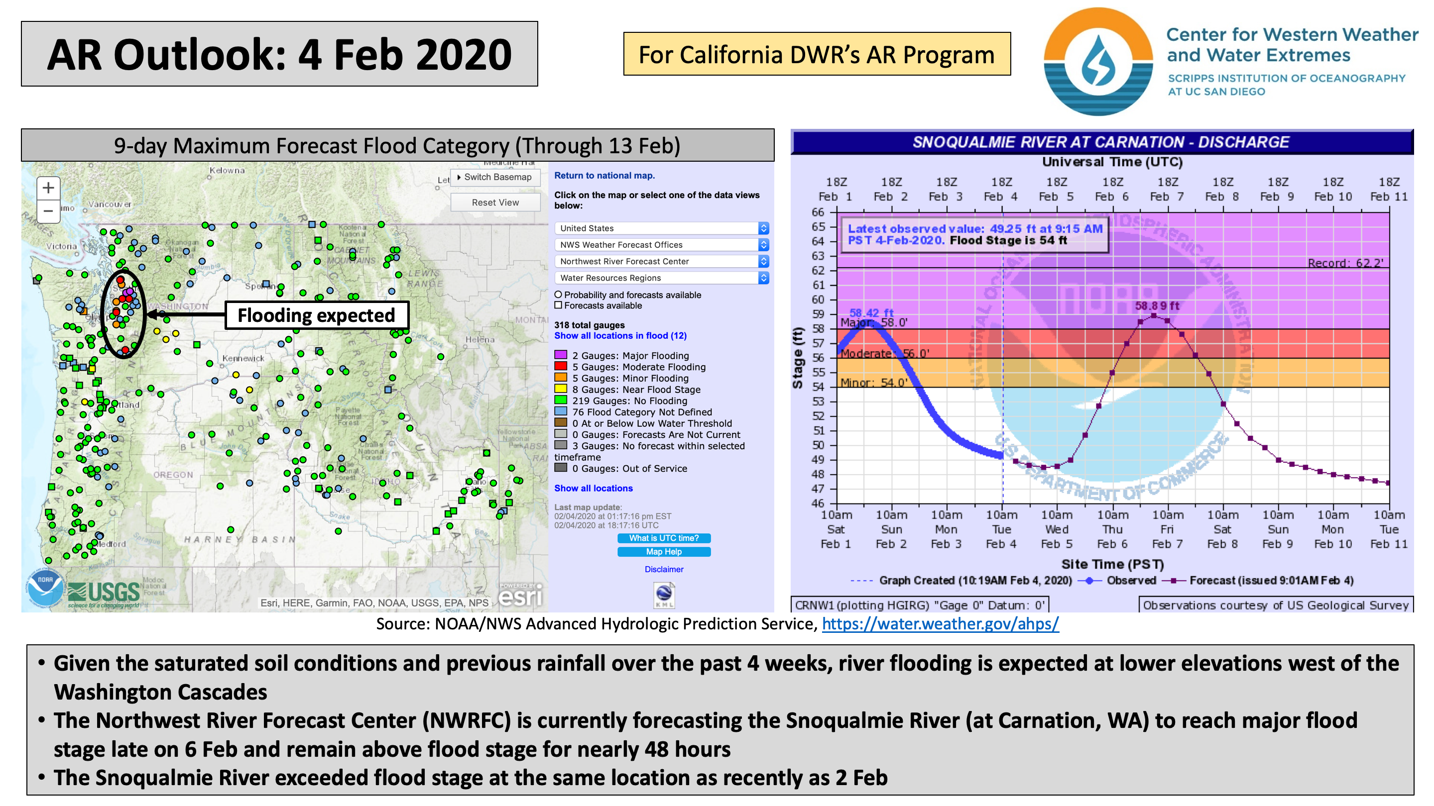
CW3E AR Update: 4 February 2020 Outlook

CW3E AR Update: 4 February 2020 Outlook

February 4, 2020

Click here for a pdf of this information.

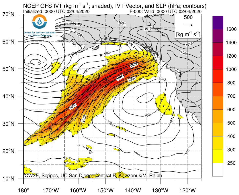
A landfalling AR will bring heavy rainfall and mountain snowfall to the Pacific Northwest

  • A landfalling AR is forecast to impact British Columbia, Washington, and Oregon this week
  • Some areas along the Washington and Oregon coast may experience AR conditions for more than 48 hours
  • Prolonged inland penetration of AR conditions is likely over the Intermountain West
  • At least 2–7 inches of precipitation are expected over portions of western Washington and northwestern Oregon during the next 3 days, with at least 12” of snowfall in the North Cascades and portions of the Intermountain West
  • River flooding is possible once again downstream of the Washington Cascades
  • Landfalling AR activity beyond Day 4 (8 Feb) is unlikely as surface high pressure builds over the Northeast Pacific Ocean

Click IVT or IWV image to see loop of GFS analyses/forecasts

Valid 0000 UTC 4 February – 0000 UTC 8 February 2020


Summary provided by C. Castellano, B. Kawzenuk, and F. M. Ralph; 4 February 2020