CW3E AR Update: 29 November 2022 Outlook

CW3E AR Update: 29 November 2022 Outlook

November 29, 2022

Click here for a pdf of this information.

Atmospheric River to bring precipitation to the U.S. West Coast

  • A strong low-pressure system associated with an upper-level shortwave trough will impact much of the US West Coast today through Thursday, with the development of an atmospheric river over Northern California
  • After the initial AR, a second low-pressure system will develop offshore and travel down the coast, bringing another round of precipitation to the region Friday into Sunday
  • There is considerable model disagreement between the GFS and ECMWF, with the ECMWF forecasting more intense AR2 conditions along the coast of California during AR landfall
  • The National Weather Service Weather Prediction Center is forecasting up to 7 inches of precipitation for mountainous regions along the border of Oregon and California during this event, with a marginal risk for excessive rainfall along the coast
  • Rivers are expected to rise in Southern Oregon and Northern California during this storm, but are not forecast to exceed flood stage as a result of this event
  • Cold air associated with the upper-level trough moving into the area will lead to lower freezing levels in the region
  • National Weather Service forecast offices across the western U.S. have begun issuing public guidance for this storm, including winter storm watches and warnings in advance of snowfall totals in exceeding 24 inches for some locations at higher elevations

Click images to see loops of GFS IVT and IWV forecasts

Valid 1200 UTC 29 November – 0000 UTC 5 December 2022


Summary provided by S. Bartlett, C. Castellano, S. Roj, M. Steen, J. Kalansky, and F. M. Ralph; 29 November 2022

To sign up for email alerts when CW3E post new AR updates click here.

*Outlook products are considered experimental

CW3E Welcomes Rosy Luna Niño

CW3E Welcomes Rosy Luna Niño

November 22, 2022

Rosy is a postdoctoral scholar whose research includes regional modeling, weather events, interannual variability, climate change, as well as their regional and local impacts. Her work has explored the dynamic of the winter phenomena: subtropical jet stream, cold fronts, winds in the Gulf of Mexico (Nortes), and their future climate projections for the 21st century. During her Ph.D. and previous collaborations, Rosy has also studied the dynamical models WRF and RegCM, to better understand and simulate regional and local processes like winter precipitation and intense winds in Mexico (Nortes, Tehuanos). Her initial work at CW3E/Scripps focuses on the statistical seasonal climate and hydrology – precipitation, temperature, streamflow – prediction for the Western US related as well as investigating the role of Atmospheric Rivers in our varying and changing hydroclimate.

CW3E Publication Notice: Seasonality of MJO Impacts on Precipitation Extremes Over the Western U.S.

CW3E Publication Notice

Seasonality of MJO Impacts on Precipitation Extremes Over the Western U.S.

November 21, 2022

A new paper entitled “Seasonality of MJO Impacts on Precipitation Extremes Over the Western U.S.” was recently published in the Journal of Hydrometeorology and authored by CW3E researcher Jiabao Wang, Mike DeFlorio (CW3E), Bin Guan (UCLA/JPL), and Chris Castellano (CW3E). As part of CW3E’s 2019-2024 Strategic Plan, CW3E seeks to improve understanding of the subseasonal-to-seasonal (S2S) predictability of extreme weather over the western U.S. and develop a comprehensive understanding of the physical mechanisms and statistical characteristics of extreme precipitation events to inform current and future resource and risk management. This study (Wang et al. 2022) discovered strong seasonality in boreal winter western U.S. extreme precipitation that is modulated by seasonality in the Madden-Julian oscillation (MJO) and its impacts on the large-scale circulation and atmospheric river (AR) activity over the North Pacific and western North America. This research was funded by the California Department of Water Resources Atmospheric River Program Phase III and the National Aeronautics and Space Administration.

This study provides observational evidence of MJO impacts on extreme precipitation intensity, frequency, and duration over the western U.S. in boreal winter. In general, the MJO impacts on extreme precipitation intensity and duration are more uncertain than its impacts on extreme precipitation frequency. A robust increase in extreme precipitation frequency relative to climatological conditions over most of the western U.S. is expected when the MJO is in the western Pacific (Phases 6-7), and opposite changes are observed when the MJO is located over the Indian Ocean and Maritime Continent. The above MJO influence, however, is characterized by strong seasonality, with an increase in extreme precipitation frequency mainly found in late autumn/early winter (October-December; OND) over California, and weaker or opposite response found in late winter (January-March; JFM) following an MJO in Phases 6-7. This seasonality largely originates from the different amplitudes and patterns of both the MJO and the North Pacific jet, which are weaker and located/retreated more northwestward in OND compared to JFM. This leads to different responses in MJO teleconnections including moisture transport and AR activity that contribute to the different changes in precipitation extremes (summarized in Fig. 1). As a result, the moisture transport in OND brings moisture from the Pacific Ocean towards the western U.S., leading to an increase in AR activity and extreme precipitation frequency over California. On the other hand, moisture transport in JFM is diverted more poleward towards Alaska, leading to a decrease in AR activity and extreme precipitation over the western U.S.

The findings in this study suggest a value for future studies to consider the seasonal dependence of the MJO-precipitation extreme relationship. The results also have implications for the source of S2S predictions, which has potential value to stakeholders including water resource managers.

Figure 1: The schematic diagram of extratropical response (precipitation extremes, 500-hPa geopotential height anomalies, anomalous moisture transport, and AR activity) to MJO phases 6-7 in (top) OND and (bottom) JFM. Results are derived from the 5-9-day lagged average after the active MJO day at day 0. The green triangle indicates the center longitude of enhanced MJO convection at day 0. The jet (mean 250-hPa zonal wind as the basic state) interval is 20 m s-1 starting at 30 m s-1. The relative magnitude of each component is indicated by the difference in the thickness and length, and the variables shown may not be entirely precise in location and pattern.

Wang, J., DeFlorio, M. J., Guan, B., & Castellano, C. M. (2022). Seasonality of MJO Impacts on Precipitation Extremes Over the Western U.S. Journal of Hydrometeorology (published online ahead of print 2022). https://doi.org/10.1175/JHM-D-22-0089.1

Enhanced Observations for Water Resilience in the Yampa River Basin: The 5th Annual Yampa Basin Rendezvous

Enhanced Observations for Water Resilience in the Yampa River Basin: The 5th Annual Yampa Basin Rendezvous

November 17, 2022

The annual Yampa Basin Rendezvous (YBR) is part of a larger CW3E effort to connect graduate students, post-doctoral scholars, researchers, staff, and faculty from CW3E to local communities of river basins throughout the West, along with local, state, and federal experts in policy and relevant science. The overarching goal of the YBR is to encourage a community-centered approach to creating informed, adaptive, proactive, and science-based management strategies for Yampa Valley’s natural resources and communities. This September, CW3E once again traveled to Steamboat Springs, Colorado, for the fifth annual Yampa Basin Rendezvous, after two years of virtual YBRs due to the pandemic. This two-day, community-oriented event, which built directly off the inaugural Rendezvous held in 2018, was organized by CW3E and partners from Colorado Mountain College, Yampa Valley Sustainability Council, Upper Yampa Water Conservancy District, and Friends of the Yampa. The day before the event, CW3E participated in the first annual Yampa Youth Water Festival. The question at the forefront of the 2022 Yampa Basin Rendezvous was: How are we, as a community, observing changes in our water cycle and working to build resilience in the face of those changes? The agenda can be found here.

Throughout the two days of the YBR, four panels and two field excursions, made up of and led by local and regional experts, provided an overview of the current state of, and future planning for, water resources in the Yampa River Basin. The event included a discussion of the role of economic, environmental, and cultural factors that influence water cycle observations for resource and resiliency planning. Understanding the health of Colorado River tributaries, such as the Yampa, through enhanced observations, is more crucial than ever this year, as downstream Lake Mead and Lake Powell sink to the lowest recorded water levels in history.

The first panel provided regional, state, and local perspectives on water priorities for resilience. The second panel was a discussion on the latest research on water efficiency, vulnerability, and critical needs as they pertain to observations. The first day ended with an afternoon field excursion to the Dry Lake Snotel station for a show-and-tell discussion on new and existing observational networks. On day 2, the first panel covered new technologies used (and old technologies used in new ways) for water resilience. The second panel provided practical insight on water stewardship and sustainable agricultural practices. The second day ended with a field excursion to Legacy Ranch in Steamboat Springs, where participants learned about soil health and water quality on working lands. All panel talks and discussions were recorded and can be viewed here.

An undergraduate student research symposium was held during the event, highlighting relevant research from students and interns at Colorado Mountain College and CW3E. Each student presented a “poster” in the form of a 3-slide lightning presentation.

CW3E is committed to continuing to grow engagement, learning, and beneficial outcomes to enhance science-and-community-based understanding and ideas to deal with a changing climate, economy and environment. The steering committee is grateful for the opportunity to partner with so many Yampa-based organizations and institutions on impactful events like the YBR, and to serve as a training ground for people across disciplines to advance their goals and careers in support of the incredible needs of the future. These needs are not only relevant for the Upper Colorado communities and environment but also of the millions of people who depend upon the precious resource it provides to people downstream.

Chuck Cullom (Upper Colorado River Commission Executive Director) presents on day 1 of YBR5 at Colorado Mountain College in Steamboat Springs, CO.

Field Excursion day 1: Kerstin Paulsson presents an update on newly installed soil moisture station while at the Dry Lake Snote sitel.

Field Excursion day 2: Clinton Whitten, National Resources Conservation Service soil scientist, leads a hands on demonstration on soil health.

CW3E S2S Outlook: 14 November 2022

CW3E S2S Outlook: 14 November 2022

November 14, 2022

Click here for a pdf of this information.


Summary provided by J. Wang, C. Castellano, M. DeFlorio, and J. Kalansky; 14 November 2022

To sign up for email alerts when CW3E post new AR updates click here.

*Outlook products are considered experimental

CW3E Adds New Radiosonde Launch Site at Seven Oaks Dam

CW3E Adds New Radiosonde Launch Site at Seven Oaks Dam

November 11, 2022

CW3E staff Hillary Beckmeyer (Field Researcher) and Ethan Morris (R&D Engineer) inaugurated a new weather balloon launch site at Seven Oaks Dam, 35 miles upstream from Prado Dam, within the Santa Ana River Watershed. Between 7-8 November 2022, a dynamic storm system featured a landfalling atmospheric river (AR) combined with a potent upper-level trough to produce strong upslope moisture flux and heavy precipitation. The launches at Seven Oaks Dam were coordinated with CW3E staff at three other locations: Scripps Pier, Yuba Water Agency in Marysville, and UC Davis Bodega Marine Lab. For further details on sampling the AR event, a summary can be found on the CW3E Sounding Google Drive.

CW3E placed a 20’ modified seavan on-site prior to the storm to have a dry space for launching and monitoring meteorological balloons. The new launch site at Seven Oaks Dam provides for more spatially comprehensive observations and improved context for meteorological site instrumentation already in place at the dam.

CW3E, with a host of partners, is currently assessing the viability of Forecast Informed Reservoir Operations (FIRO) at nearby Prado Dam, and will use the enhanced monitoring at Seven Oaks Dam to learn more about AR structure and evolution in southern California to improve upon weather and water forecasts. The goal is for the additional data collected from Seven Oaks Dam as part of FIRO, amongst a large suite of data collection, modeling, and other studies, to be integrated into decisions to retain or release water from Prado Dam.

CW3E is grateful to have such supportive partnerships in this endeavor with the Orange County Water District (OCWD), US Army Corps of Engineers (USACE), and San Bernardino County Public Works (SBCPW). Additionally, the assistance of the security team at the dam was instrumental in facilitating access throughout the entirety of the event.

CW3E Launches a New Website Focused on Equity, Diversity, and Inclusion Efforts at the Center

CW3E Launches a New Website Focused on Equity, Diversity, and Inclusion Efforts at the Center

November 10, 2022

CW3E has launched a new website focused on Equity, Diversity, and Inclusion (EDI). This new platform highlights ongoing efforts to improve diversity at the Center and in the field of Geoscience through education, outreach, and partnerships. A core value of CW3E is to foster a workplace culture of respect and belonging, and to embrace the many dimensions of diversity to broaden our perspectives and learn from each other. We are committed to sharing our work and knowledge with others both within and outside the academic community to further the advancement of Geoscience and make our research more accessible. Please read about our ongoing activities including:

  • CW3E core values and commitment to EDI principles
  • The EDI task force
  • Women of AR Recon news feature
  • Ongoing work with K-12 through Groundwork San Diego (Earthlab)
  • Education Collaboration with Yuba Water Agency
  • Summer Intern Program
  • Unlearning Racism in Geoscience (URGE)
  • News highlights covering EDI activities going on at the Center

To view the new website, go to /edi/. You can also find it under the “About” tab on our main site https://cw3e.ucsd.edu (click on the “Equity, Diversity, & Inclusion (EDI)” button from the drop-down menu).

CW3E Event Summary: 7-8 November 2022

CW3E Event Summary: 7-8 November 2022

November 10, 2022

Click here for a pdf of this information.

A Moderate Strength Atmospheric River with Strong Dynamical Forcing Produced Heavy Precipitation Throughout California

  • California was impacted by a dynamic storm system on 7 and 8 November that featured both a landfalling AR and potent upper-level trough that combined to produce strong upslope moisture flux and heavy precipitation
  • The AR was ranked as an AR2 (based on the Ralph et al. 2019 AR Scale) was observed in coastal San Diego County with AR conditions persisting for 24 consecutive hours with maximum IVT values exceeding 500 kg m−1 s−1
  • Precipitation totals in the Transverse Ranges of Southern California exceeded 8 inches with widespread totals around the state exceeding 2 inches
  • More than 2 feet of snow fell throughout the Sierra Nevada Mountains with locations in the Central and Southern Sierra picking up as much as 5 feet of snow
  • CW3E’s surface meteorology station at Seven Oaks Dam observed 2 inches of rain during the event, accounting for roughly 60% of water year to date precipitation at the dam
  • Debris flows occurred in the vicinity of the El Dorado and Apple fires, which were under evacuation warnings, as well as in other parts of the San Bernardino Mountains causing HWY 38 and 18 to close for a short time
  • The NWS confirmed that an EF-0 tornado touched down on 8 Nov near Galt in Sacramento County

MIMIC-TPW2 Total Precipitable Water

Valid 0000 UTC 6 November – 0000 UTC 10 November 2022


Summary provided by S. Roj, S. Bartlett, J. Cordeira, C. Castellano, J. Kalansky, and F.M. Ralph; 10 November 2022

To sign up for email alerts when CW3E post new AR updates click here.

*Outlook products are considered experimental

CW3E Event Summary: 3-5 November 2022

CW3E Event Summary: 3-5 November 2022

November 9, 2022

Click here for a pdf of this information.

Strong Atmospheric River Brings Heavy Precipitation to Northwestern US

  • A strong atmospheric river (AR) made landfall over the Pacific Northwest on 3 Nov
  • The first AR produced AR 3/AR 4 conditions (based on the Ralph et al. 2019 AR Scale) in coastal Oregon and southern coastal Washington
  • AR 3 conditions (based on the Ralph et al. 2019 AR Scale) were observed in coastal Washington and northern coastal Oregon, while AR 1/AR 2 conditions were observed in southern coastal Oregon and coastal Northern California
  • AR 2/AR 3 conditions were also observed east of the Cascades due to significant inland penetration of the AR
  • This AR produced at least 5–10 inches of precipitation over portions of western Washington and northwestern Oregon, as well as 2–5 inches of precipitation in parts of the interior northwestern US
  • At least 1–3 feet of snow fell in the higher terrain of the Washington Cascades, the Blue Mountains, and the Northern Rockies
  • Heavy rainfall on 4 Nov caused riverine flooding on the western side of the Washington Cascades, with multiple rivers exceeding moderate flood stage
  • Strong winds on 4 Nov downed trees and power lines, resulting in numerous power outages in northwestern Washington
  • This AR was sampled by the 53rd Weather Reconnaissance Squadron as the first mission of the 2023 AR Recon season, with data from 23 dropsondes assimilated into the 00Z 5 Nov GFS model run

MIMIC-TPW2 Total Precipitable Water

Valid 0000 UTC 3 November – 0000 UTC 6 November 2022


Summary provided by C. Castellano, S. Bartlett, J. Cordeira, J. Kalansky, S. Roj, and F.M. Ralph; 9 November 2022

To sign up for email alerts when CW3E post new AR updates click here.

*Outlook products are considered experimental

CW3E Kicks off the Water Year 2023 West-WRF Forecast Season

CW3E Kicks off the Water Year 2023 West-WRF Forecast Season

November 7, 2022

The Center for Western Weather and Water Extremes (CW3E) at Scripps Institution of Oceanography runs a weather prediction system called ‘West-WRF’ that has been optimized for predicting rainfall along the West Coast primarily from atmospheric rivers (AR). Forecast data from West-WRF is used by water managers to improve reservoir operations and to inform CW3E AR reconnaissance activities.

The West-WRF forecast season kicked off on 1 October for water year (WY) 2023 with several new additions and enhancements. Starting the West-WRF forecast season in October is two months earlier than the previous year and is motivated by a collaboration with San Diego Gas and Electric (SDG&E) to capture more of the Southern California fire weather season. The WY2023 West-WRF weather prediction system consists of four sets of unique daily forecasts that are run on the Comet high-performance supercomputer that is managed by the San Diego Supercomputer Center (SDSC).

West-WRF Deterministic Forecasts

Three deterministic West-WRF forecasts are run daily during the WY2023 season. Two of the deterministic forecasts are initialized with GFS and ECMWF initial conditions and run with 100 vertical levels on three numerical grids at 9, 3, and 1 km horizontal grid spacing (as shown in Figure 1). For this West-WRF season, the outermost 9 km numerical grid was extended roughly 700 km to the east to include the Rocky Mountains so that the potential impact of ‘Backdoor Slider’ storm systems on Southern California is better predicted. Also, the 9 km grid was extended around 1200 to the west to provide additional information for CW3E’s AR reconnaissance program. The 1 km grid spacing West-WRF domain covering portions of Northern California is new for this forecast season and is motivated by improving precipitation estimates in complex topography. Running an additional model domain this season was possible due to optimizations of the West-WRF model executable on Comet, which reduced forecast run times by around 15%.

Another new feature for this season is the GFS and ECMWF based deterministic forecasts are now run daily at both 00 and 12 UTC. Forecast lead times for the deterministic runs are 10 days for the 9 km grid, 5 days for the 3 km, and 3 days for the 1 km numerical grid. An additional GFS-based deterministic forecast is run daily on 60 levels for 9 and 3 km domains (fixed since 2019) for CW3E machine learning research.

West-WRF Ensemble Forecast

In addition to the deterministic forecast runs, the CW3E West-WRF system runs a 200-member forecast ensemble initialized daily at 00 UTC. The West-WRF ensemble provides a probabilistic weather forecast by varying initial conditions, model physics, and applying a stochastic (i.e., a random probability distribution) perturbation to represent model error. As a result, a suite of physically plausible forecast scenarios are generated by the ensemble, which is particularly advantageous for identifying potential extreme weather events. The West-WRF ensemble has a forecast lead time of 7 days and is run with 60 vertical levels on a single 9 km grid horizontal spacing domain, consistent with the deterministic runs. An example West-WRF ensemble forecast product showing the probability of 24-hr total rainfall exceeding 1 inch over California is shown in Figure 2. The example product highlights the value of the West-WRF ensemble due to its ability to communicate forecast confidence.

Fig 1: Geographic coverage of the CW3E West-WRF deterministic forecast numerical grids at 9, 3 and 1 km horizontal grid spacing for water year 2023. The West-WRF 200-member ensemble runs on the same 9 km grid as the deterministic forecasts.

Fig 2: Example West-WRF ensemble product showing the probability of 24-hr total rainfall exceeding 1 inch on forecast day 5 for a model run initialized at 00 UTC on 4 November 2022.

This work used the Comet supercomputer, which was made available by the Atmospheric River Program Phase 2 and 3 supported by the California Department of Water Resources and the Forecast Informed Reservoir Operations Program supported by the U.S. Army Corps of Engineers Engineer Research and Development Center.

CW3E thanks the AR Program, USACE, and San Diego Gas and Electric for support in running the WY2023 West-WRF system and configuration enhancements.

Inquiries should be directed to Daniel Steinhoff, Matthew Simpson, or Luca Delle Monache.

CW3E Hosts 3rd Annual Atmospheric River Reconnaissance Workshop

CW3E Hosts 3rd Annual Atmospheric River Reconnaissance Workshop

November 7, 2022

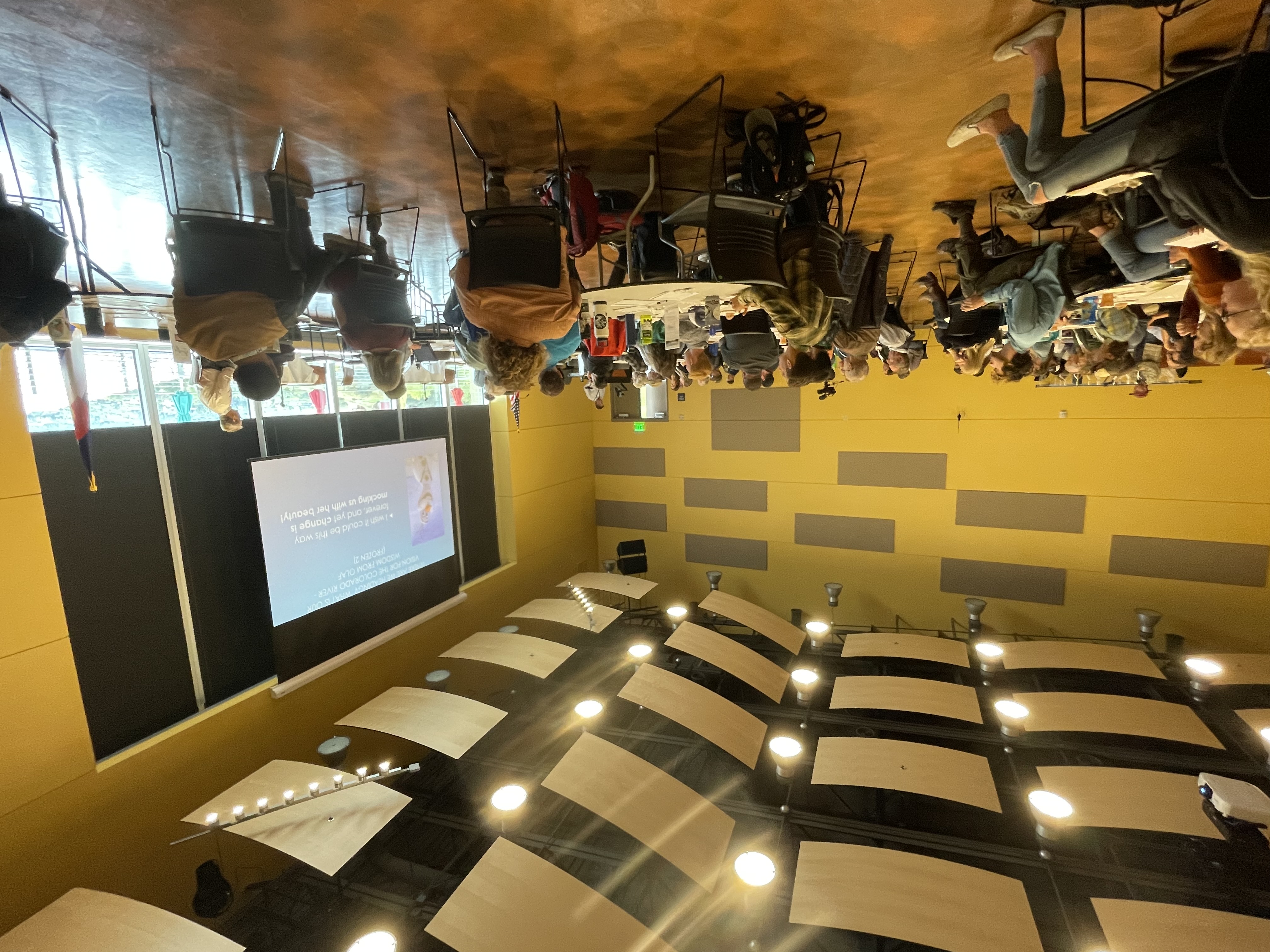
CW3E hosted the third annual, and first in-person, Atmospheric River Reconnaissance (AR Recon) Workshop at Scripps Institution of Oceanography’s Seaside Forum on October 24–26, 2022, with a hybrid component for remote collaborators. The workshop brought together the operational AR Recon team responsible for forecasting and flight planning, representatives from NOAA’s Aircraft Operations Center and the 53rd Weather Reconnaissance Squadron that conduct the flights, and other interested experts and researchers who utilize the vast amounts of accumulated data for various scientific purposes. Goals of the workshop included highlighting the accomplishments of prior seasons, sharing results of recent modeling efforts, defining areas of optimizations for current operations, and outlining a shared vision for the future of AR Recon.

CW3E Director Dr. Marty Ralph kicked off the meeting with a presentation outlining the 5-year vision for the growth of AR Recon through Water Year 2028. This plan includes the near-term goals of lengthening the AR Recon season in the northeastern Pacific and coordinating with the East Coast Winter Storm Reconnaissance teams to conduct flights sampling ARs over the western Atlantic and the Gulf of Mexico. Director Ralph also outlined longer-term goals of the program, which include continuing to expand AR Recon flights to increase the spatio-temporal coverage and volume of data collected.

Day one of the workshop began with a discussion of the Air Force C130 and NOAA G-IV aircraft and the complexities associated with maintaining and deploying each mission platform. Representatives from each group highlighted the role each aircraft will play during this AR Recon season, with responsibilities including launching dropsondes, Airborne Radio Occultation (ARO) measurements in collaboration with Scripps ARO PI Dr. Jennifer Haase, and drifting buoy deployment in collaboration with the NOAA-funded Global Drifter Program led by the Scripps Lagrangian Drifter Laboratory (PI: Dr. Luca Centurioni). The last session of day one provided opportunities to discuss the longer AR Recon season in the Eastern Pacific as well as expansion into the eastern U.S. and Gulf of Mexico. The day concluded with a reception and poster session highlighting AR Recon research.

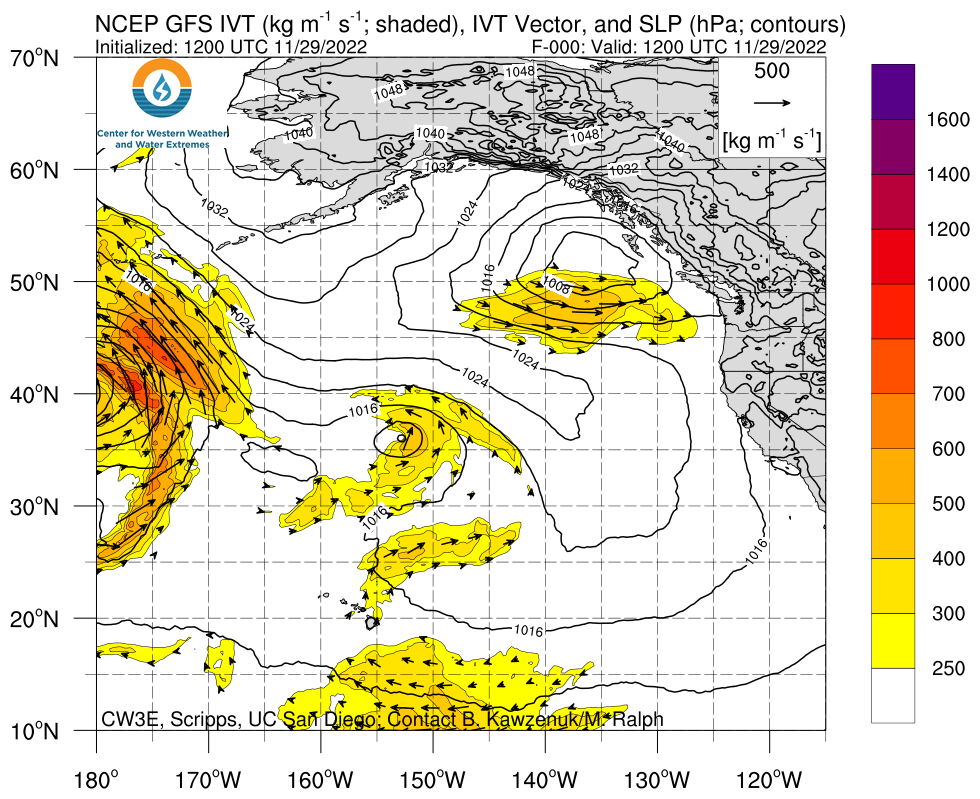
The second day of the workshop revolved around modeling, data assimilation, and impact studies related to AR Recon. Meeting participants from a variety of institutions, including the National Centers for Environmental Prediction (NCEP), CW3E, the Naval Research Laboratory (NRL), the European Centre for Medium-Range Weather Forecasts (ECMWF), the National Center for Atmospheric Research (NCAR), and CU Boulder provided updates on related topics. These talks highlighted the positive impacts of observations from dropsondes, drifting buoys, and satellites on model forecasts of integrated water vapor transport (IVT) and precipitation following AR Recon flights during recent winters. Several speakers also discussed ongoing efforts to improve data assimilation in numerical weather prediction models. AR Recon co-PI, Dr. Vijay Tallapragada, provided a brief update on planned upgrades to NCEP’s deterministic (GFS) and ensemble (GEFS) forecast models.

The third day of the workshop began with a presentation from seasonal-to-subseasonal (S2S) researcher, Dr. Michael DeFlorio, who demonstrated the current suite of S2S forecast products on CW3E’s website and provided an outlook for the beginning of the AR Recon season. Following the S2S briefing, the morning session focused on scientific advances in the physical processes of meteorology that have come from AR Recon-related studies, with talks from researchers at CW3E, ECMWF, and SUNY Albany. Senior scientists for the upcoming North Atlantic Waveguide, Dry Intrusion, and Downstream Impact Campaign (NAWDIC) field campaign led a discussion on the research informing the study design. In the afternoon, researchers from CW3E, NRL, NCEP, and SUNY Albany all shared their perspectives on forecasting and sensitivity strategies for AR Recon.

The workshop featured lots of engagement and in-depth discussion between the participants. Interactive discussions were scheduled daily, complementing sessions featuring oral presentations. Excellent progress was made during these discussions and many follow up activities are planned.

This workshop integrates several of the CW3E priorities from the five year strategic plan including Atmospheric Rivers Research and Applications, Emerging technologies and Modeling capabilities for the Western US.

AR Recon Workshop Session Topics (full agenda here):

AR Recon Observations

Expanding AR Recon

Modeling, Data Assimilation, and Impact Studies

Scientific Advances in Physical Process Understanding

Forecasting and Sensitivity Strategies

AR Recon Workshop in-person participants.

CW3E AR Update: 4 November 2022 Outlook

CW3E AR Update: 4 November 2022 Outlook

November 4, 2022

Click here for a pdf of this information.

Major Winter Storm Expected to Impact California Early Next Week

  • An early-season winter storm is forecast to bring precipitation to much of California, with heavy snow likely in the Sierra Nevada
  • Precipitation during this event will be fueled by a combination of strong dynamical forcing downstream of an upper-level trough and upslope moisture flux as the trough interacts with a weakening atmospheric river (AR) currently over the Pacific Northwest
  • The heaviest precipitation is forecast over the Sierra Nevada, eastern Transverse Ranges, and Peninsular Ranges, with 3–6 inches of total precipitation expected in these areas
  • There is still considerable uncertainty in storm-total precipitation over Central and Southern California, with large differences between the 00Z GFS and 00Z ECMWF models
  • Due to low freezing levels, a significant portion of the storm-total precipitation is expected to fall as snow in the watersheds surrounding the Sierra Nevada
  • More than 2 feet of snow is forecast over the much of the Sierra Nevada

Click images to see loops of GFS 500-hPa Vorticity & IVT forecasts

Valid 1200 UTC 6 November – 1200 UTC 9 November 2022


Summary provided by C. Castellano, C. Hecht, J. Kalansky, S. Roj, and F. M. Ralph; 4 November 2022

To sign up for email alerts when CW3E post new AR updates click here.

*Outlook products are considered experimental

CW3E AR Update: 2 November 2022 Outlook

CW3E AR Update: 2 November 2022 Outlook

November 2, 2022

Click here for a pdf of this information.

Strong Atmospheric River to Impact Washington and Oregon

  • A strong atmospheric river will make landfall along the coast of British Columbia and slide south along the coast of Washington and Oregon, bringing AR3/AR4 (based on the Ralph et al. 2019 AR Scale) conditions to the area
  • The AR is also forecast to bring AR2/AR3 conditions to locations east of the Cascades in interior Washington and Oregon
  • The NWS Weather Prediction Center is forecasting more than 5 inches of total precipitation in portions of western Washington and Oregon over the next 5 days
  • There are significant differences in forecast precipitation between the 00Z GFS and 00Z ECMWF, with the GFS showing a stronger rain shadow effect east of the Olympic Mountains and Cascades
  • High freezing levels will limit snowfall accumulations below 7,000 ft, but strong uplsope moisture flux and inland penetration of the AR will likely produce significant snowfall in the higher terrain of the North Cascades and Northern Rockies
  • Precipitation from this storm will bring favorable conditions for debris flows in areas of Washington and Oregon with burn scars from recent fire seasons
  • As part of CW3E’s Atmospheric River Reconnaissance program, this event will be sampled by the 53rd Weather Reconnaissance Squadron on 3 November, feeding meteorological data into the global forecast models

Click images to see loops of GFS IVT & IWV forecasts

Valid 1200 UTC 2 November – 1800 UTC 6 November 2022


Summary provided by S. Bartlett, C. Castellano, S. Roj, J. Kalansky, C. Hecht, B. Kawzenuk and F. M. Ralph; 2 November 2022

To sign up for email alerts when CW3E post new AR updates click here.

*Outlook products are considered experimental

CW3E Welcomes Jia Wang

CW3E Welcomes Jia Wang

November 1, 2022

Dr. Jia Wang joined CW3E as a postdoctoral scholar in September 2022. She received her B.S. from Nanjing University of Information Science & Technology (2009), and her M.S. from the Chinese Academy of Meteorological Sciences (2012) in China. She completed her Ph.D. from the School of Marine and Atmospheric Sciences at Stony Brook University under the advisement of Prof. Minghua Zhang (2022).

In Jia’s Ph.D. work, she developed a constrained data assimilation (DA) framework based on the Gridpoint Statistical Interpolation (GSI) three-dimensional ensemble variational (3D-EnVar) data assimilation method. In this framework, dynamical constraints, including the column-integrated mass and moisture conservation, are implemented as weak constraints. Through studies of mesoscale convective cases during the Midlatitude Continental Convective Clouds Experiment (MC3E) field campaign, this constrained DA algorithm shows improvements in analyses and the subsequent short-range forecasts. Considering high spatial and temporal resolution of radar observations, she also explored the impact of radar data (radial winds and reflectivity) assimilation on analyses and forecasts using the constrained DA framework.

At CW3E, Jia will work in the data assimilation group under the supervision of Dr. Minghua Zheng. She will also work closely with Dr. Luca Delle Monache and other DA researchers and scientists from Scripps Institution of Oceanography and CW3E’s collaborating modeling centers. She will mainly participate in the Advanced Quantitative Precipitation Information (AQPI) project and develop data assimilation algorithms for assimilating radar observations from the Next Generation Weather Radar (NEXRAD) system and AQPI project in the West-WRF model. In particular, she will implement new DA techniques for radar observations to improve short-range forecasts of precipitation events over the U.S. West that are frequently associated with landfalling Atmospheric Rivers.

CW3E AR Update: 31 October 2022 Outlook

CW3E AR Update: 31 October 2022 Outlook

October 31, 2022

Click here for a pdf of this information.

Strong Atmospheric River Forecast to Impact Pacific Northwest Later this Week

  • An atmospheric river (AR) made landfall yesterday, bringing AR 1/AR 2 conditions (based on the Ralph et al. 2019 AR Scale) to coastal Washington and Oregon
  • This AR produced heavy rainfall in western Washington, with portions of the Olympic Peninsula receiving more than 5 inches of precipitation since Sunday morning
  • An upper-level shortwave trough will interact with the remnants of the first AR, bringing the first significant snowfall of the season to the Sierra Nevada
  • A stronger AR is forecast to make landfall over Washington on Thursday and gradually move southward into Oregon and California
  • AR 3/AR 4 conditions are currently forecast across much of coastal Washington and Oregon, with AR 1/AR 2 conditions forecast in Northern California
  • AR 2/AR 3 conditions are also possible in interior Washington and Oregon due to significant inland penetration of the second AR
  • The NWS Weather Prediction Center is forecasting more than 5 inches of total precipitation over portions of western Washington and Oregon during the next 7 days
  • Additional heavy rainfall in areas that received heavy precipitation from the first AR could lead to riverine flooding in western Washington
  • Significant snowfall is possible in the higher terrain of the North Cascades during the second AR

Click images to see loops of GFS IVT & IWV forecasts

Valid 1200 UTC 31 October – 1200 UTC 7 November 2022


Summary provided by C. Castellano, C. Hecht, S. Bartlett, S. Roj, and F. M. Ralph; 31 October 2022

To sign up for email alerts when CW3E post new AR updates click here.

*Outlook products are considered experimental