CW3E Publication Notice: Object-based Verification of Atmospheric River Predictions in the Northeast Pacific

CW3E Publication Notice

Object-based Verification of Atmospheric River Predictions in the Northeast Pacific

July 27, 2021

Laurel DeHaan, an applications programmer at CW3E, recently published a paper (DeHaan et al., 2021) in Weather and Forecasting, along with co-authors from CW3E (Rachel Weihs, Luca Delle Monache, and F. Martin Ralph) and Portland State University (Andrew Martin), titled “Object-based Verification of Atmospheric River Predictions in the Northeast Pacific.” This study contributes to the goals of CW3E’s 2019-2024 Strategic Plan to support Atmospheric River (AR) Research and Applications by advancing the metrics and methods used in AR forecast verification. Verification metrics of AR forecasts are an important component of assessing forecast informed reservoir operations (FIRO) viability and enable other end users to objectively assess the quality of a specific forecast or the performance of a numerical weather prediction model in general.

In this study, a new verification framework is proposed leveraging freely available software and metrics used successfully for other applications. Specifically, AR detection and statistics are computed for the first time using the Method for Object-based Diagnostic Evaluation (MODE). In addition, the measure of effectiveness (MoE) is introduced as a new metric for understanding AR forecast skill in terms of size and location. The MoE provides a quantitative measure of the position of an entire forecasted AR compared to observation, regardless of whether the AR is making landfall. In addition, the MoE can provide qualitative information about the evolution of a forecast by lead time with implications about the predictability of an AR. For example, three different cases illustrate how the MoE can identify errors in AR size and show variability with lead time in Figure 1. This study also analyzes AR forecast verification and skill using 11 years of cold season forecasts from two numerical weather prediction models, one global and one regional. Four different thresholds of integrated vapor transport (IVT) are used in the verification revealing differences in forecast skill based on the strength of an AR (Figure 2). In addition to MoE, AR forecast skill is also addressed in terms of intensity error, landfall position error, and contingency table metrics. These metrics show that the models had more difficulty in predicting the existence, size, and location of higher intensity ARs compared to their ability to predict those characteristics for lower intensity ARs. However, when the models correctly predicted the existence of a higher intensity AR, there was more forecast skill in terms of relative intensity error and landfall position error than lower threshold ARs.

Figure 1: Measure of Effectiveness for forecasts valid Feb 6, 2015 (left), Feb 10, 2016 (middle), and Feb 12, 2017 (right). The Feb 6 case demonstrates somewhat consistent AR forecasts where the area of the forecasted AR is generally too large. The Feb 10 case demonstrates large shifts in the AR forecast by lead time. The Feb 10 case demonstrates 2 different AR forecast regimes: one for the 24–72 hour forecasts, the other for the 96-168 hour forecasts. (Figure 3 from DeHaan et al., 2021).

Figure 2: 2007-2017 average MoE for West-WRF (stars) and GEFS (circles) for thresholds of 250 (top left), 500 (top right), 750 (bottom left) and 1000 (bottom right) kg m–1 s-1. Diameter is a function of the standard deviation of the MoE values. Both models produce ARs that are the correct size (on the diagonal) on average in most cases, with a slight bias towards ARs that are too large at the 24-hour lead time. Increasing difficulty in forecasting the correct AR location with higher thresholds can be seen by the dots moving farther away from the upper right-hand corner as the threshold increases. (Figure 7 from DeHaan et al., 2021).

DeHaan, L. L., Martin, A. C., Weihs, R. R., Delle Monache, L., & Ralph, F. M. (2021). Object-based Verification of Atmospheric River Predictions in the Northeast Pacific Weather and Forecasting (published online ahead of print 2021), https://doi.org/10.1175/WAF-D-20-0236.1

CW3E Conducts Radiosonde Launch with UCSD-EarthLab High School Students

CW3E Conducts Radiosonde Launch with UCSD-EarthLab High School Students

July 27, 2021

On July 15th, CW3E Field Researchers Carly Ellis and Ava Cooper conducted a radiosonde launch and discussion on the Scripps Pier for UCSD-EarthLab Community Station, a partnership between UCSD Center on Global Justice and Groundwork San Diego-Chollas Creek. The UCSD-EarthLab Community Station is a 4-acre climate action park, designed for experiential outdoor education for underserved communities. Education is a CW3E core value and the Center appreciates the opportunity to connect young students with local scientists. CW3E hopes to continue working with UCSD-EarthLab Community Station to increase student access to and interest in STEM for years to come.

About 15 high school students from Groundwork’s Green Team, a summer internship program, joined CW3E to discuss surface meteorological instrumentation and participate in a weather balloon launch. Discussion focused on how the instrumentation works, what it measures, and how this knowledge and research can be used to improve forecasting and water resource management. During the demonstration students were actively engaged, asked thoughtful questions, and assisted in the process of preparing and releasing the weather balloon. There were many opportunities for hands-on learning and even marine wildlife sightings!

Additional CW3E staff (Kerstin Paulsson and Peter Yao), post-docs (Negin Hyatbini), students (Cody Poulsen), and interns (Diana Montoya-Herrera and Levi Newell) also helped throughout the day and shared their own journeys and experiences in STEM.

Because this event was scheduled during our annual CW3E Internship Program, the team also launched a radiosonde with this year’s intern cohort. Some interns had already participated in balloon launches elsewhere and were able to share their experience and knowledge of soundings with their peers.

Field Researcher Ava Cooper, Research Data Analyst Peter Yao, Graduate Student and Intern Program Lead Cody Poulsen, and Interns Levi Newell and Diana Montoya-Herrera talk with UCSD-EarthLab Community Station students about the surface meteorology station on the pier.

UCSD-EarthLab Community Station students release a radiosonde on Scripps Pier

CW3E Hosts Second Annual Atmospheric River Reconnaissance (AR Recon) Workshop

CW3E Hosts Second Annual Atmospheric River Reconnaissance (AR Recon) Workshop

July 20, 2021

The second annual Atmospheric River Reconnaissance (AR Recon) Workshop was held virtually from 8-11 am Pacific Time each morning June 28 – July 1.

The purpose of the AR Recon Workshop was to document impacts and envision AR Recon out to 2025. The goals were to share results, to coordinate and inspire future work on data collection, data assimilation, metric development and impact assessment, and to discuss the research and operations partnership approach being developed in AR Recon.

The workshop was organized by the AR Recon Modeling and Data Assimilation Steering Committee. Workshop co-chairs were CW3E Director Marty Ralph, Chief of the Modeling and Data Assimilation Branch of the Environmental Modeling Center at NCEP Vijay Tallapragada, and Naval Research Laboratory Senior Scientist Jim Doyle. The workshop brought together nearly 100 attendees from leading academic institutions around the globe and US and international agencies to focus on AR Recon and its impact on AR prediction. In addition, the workshop provided an opportunity for students, postdocs, and other early career researchers to participate in developing a road map for future AR Recon efforts.

The meeting began with opening remarks from workshop co-chairs. The first day’s schedule focused on the Research and Operations Partnership and included perspectives from partners in the Air Force and NOAA Aircraft Operations Center. A summary of observations collected as part of AR Recon was presented, which included those from dropsondes, buoys, radiosondes, and Airborne Radio Occultation (ARO).

The second day was focused on AR Recon sampling strategy, with essential atmospheric structures highlighted as the primary target. The use of several different sensitivity tools, based on the Naval Research Laboratory’s adjoint model, and ensemble forecasts from different global operational numerical weather prediction centers, which provide information on locations where additional observations may help to constrain the forecast, was also covered.

On the third day, we heard results of studies looking at the impacts of AR Recon data on forecasts. Exciting results were shared by all modeling centers partnering in the AR Recon Modeling and Data Assimilation Steering Committee, including CW3E, NCEP, ECMWF, NRL, and NCAR. One outcome was the decision to coordinate a case study of a sequence of Intensive Observation Periods (IOPs) to examine in detail.

The final day of the workshop there were facilitated discussions on topics including collaborations with European colleagues to develop AR Recon in the Atlantic, leveraging plans for the North Atlantic Waveguide, Dry Intrusion, and Downstream Impact Campaign (NAWDIC) effort (a follow-on campaign to NAWDEX); sampling strategies thus far and in future; and coordinated case study plans. Excellent progress was made during these discussions and follow up activities are planned on all topics.

Day 1: Session I: AR Recon: Research And Operations Partnership (RAOP)

Day 2: Session II: AR Recon Sampling Strategy: Essential atmospheric structures

Session III: AR Recon Sampling Strategy: Sensitivity tools

Day 3: Session IV: Data Assimilation and Impact Studies

Day 4: Session V: AR Recon Vision – Facilitated Discussions

Throughout, the workshop was very participatory and featured lots of engaged and in depth discussion between the participants.

This workshop integrates several of the CW3E priorities from the 5 year strategic plan including Atmospheric Rivers Research and Applications, Emerging technologies and Modeling capabilities for the Western US.

AR Recon Workshop participants before adjourning the virtual meeting on July 1, 2021.

The Women of AR Recon

The Women of AR Recon

July 20, 2021

Atmospheric River Reconnaissance (AR Recon) is a Research And Operations Partnership (RAOP) between CW3E, NOAA, the Airforce, Naval Research Lab and several academic institutions. The AR Recon Program originated as three missions carried out in 2016 and has been expanding in the number of observations and partners since 2016. AR Recon supports water management decisions and flood forecasting by collecting targeted airborne and buoy observations over the Northeast Pacific to improve forecasts of the landfall and impacts of atmospheric rivers on the U.S. West Coast. The 2021 season of AR Recon wrapped up in March, Women’s History Month, so we interviewed some of the inspiring women involved to get to know them in their own words!

Anna Wilson is CW3E’s Field Research Manager. She is responsible for making sure we collect observations that 1) provide critical support for Western U.S. monitoring and forecasting, and 2) enable us to answer our research questions and move the science forward. These observations may be taken both offshore and onshore.

What was your role in AR Recon this winter?

Part of my role as the Field Research Manager is to serve as AR Recon Coordinator each year. My responsibilities include facilitating our daily meetings; handling all communications between flight directors and flight planners as well as the whole team; setting up document and information sharing; and making sure transitions between roles are seamless. This year I was also able to serve as Mission Director, which meant I was trusted to make the final calls, after getting input from our expert team, on whether or not to fly and on the flight track design.

What was your favorite or most memorable moment of AR Recon this year?

I happened to be able to meet up with the Air Force in Reno before the first mission this year, as I was on my way to be stationed in Bodega Bay with Ava Cooper. Being in person with the Flight Directors is a huge bonus during AR Recon, and makes communication and planning infinitely easier. Of course, that wasn’t possible the rest of the year, but being able to join them (with pandemic safety protocols) during the first forecast meeting in such an unprecedented year was definitely memorable.

What accomplishments are you most proud of this winter?

I am really proud of the entire team for supporting almost double the number of missions that we did last year. This was especially challenging, as everything was, because of coronavirus, but is a major accomplishment in any year. We are also already seeing the positive effects of these observations on forecasts and I anticipate only more as we dig further into this year’s case studies.

Who inspired you and helped you get to where you are today?

I have had a number of amazing mentors and supporters throughout my career from professors to colleagues to my family. I feel really lucky to have such a broad support network and a truly lovely, smart, generous, dedicated group of people with whom to work.

Kerstin Paulsson is a Field Researcher, and the designated field team cheer stunt instructor! As a member of the field team, she helps install, maintain, and monitor CW3E’s meteorological stations across the state as well as perform data quality control and analyses on the observational data.

What was your role in AR Recon this winter?

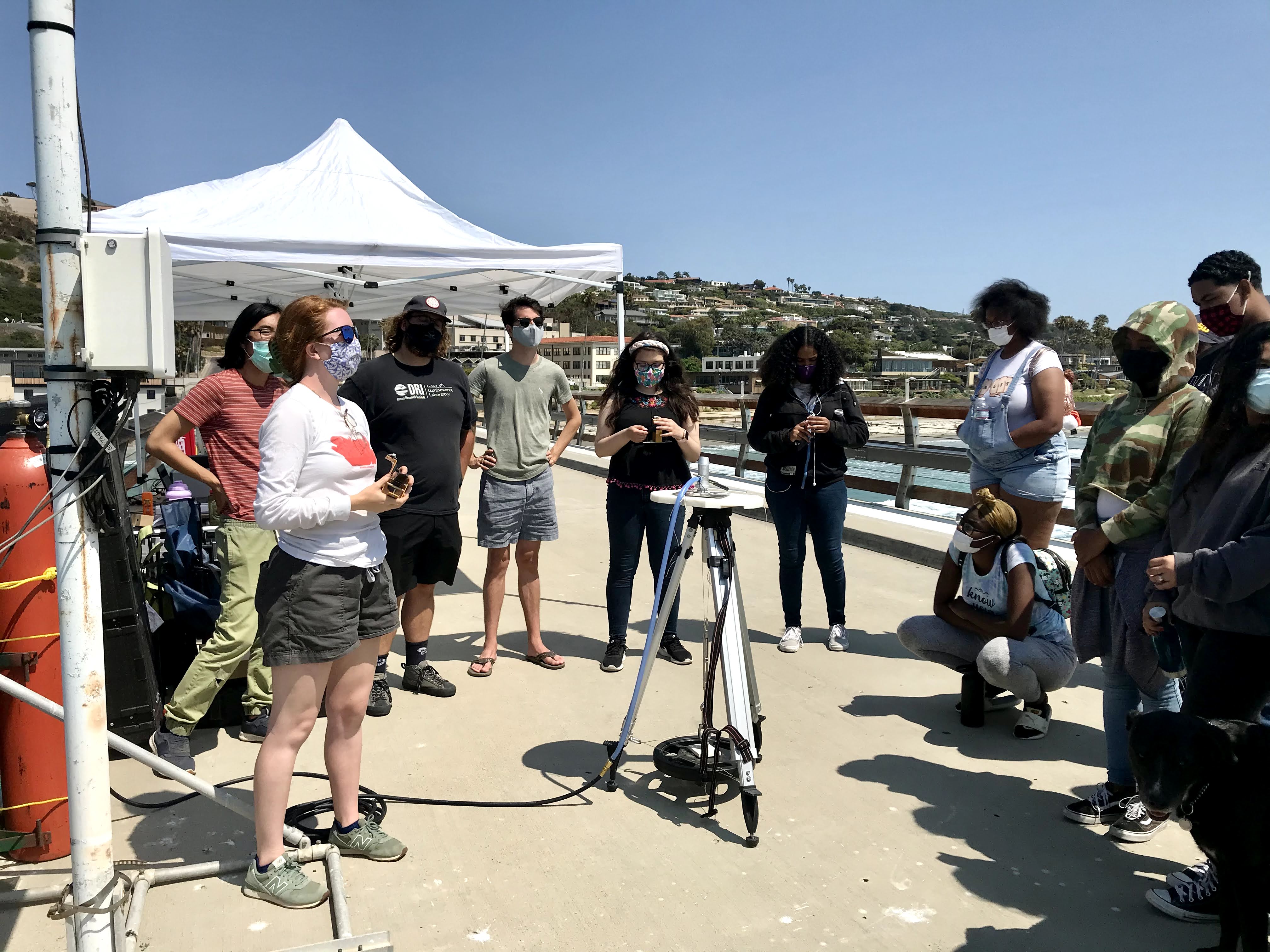
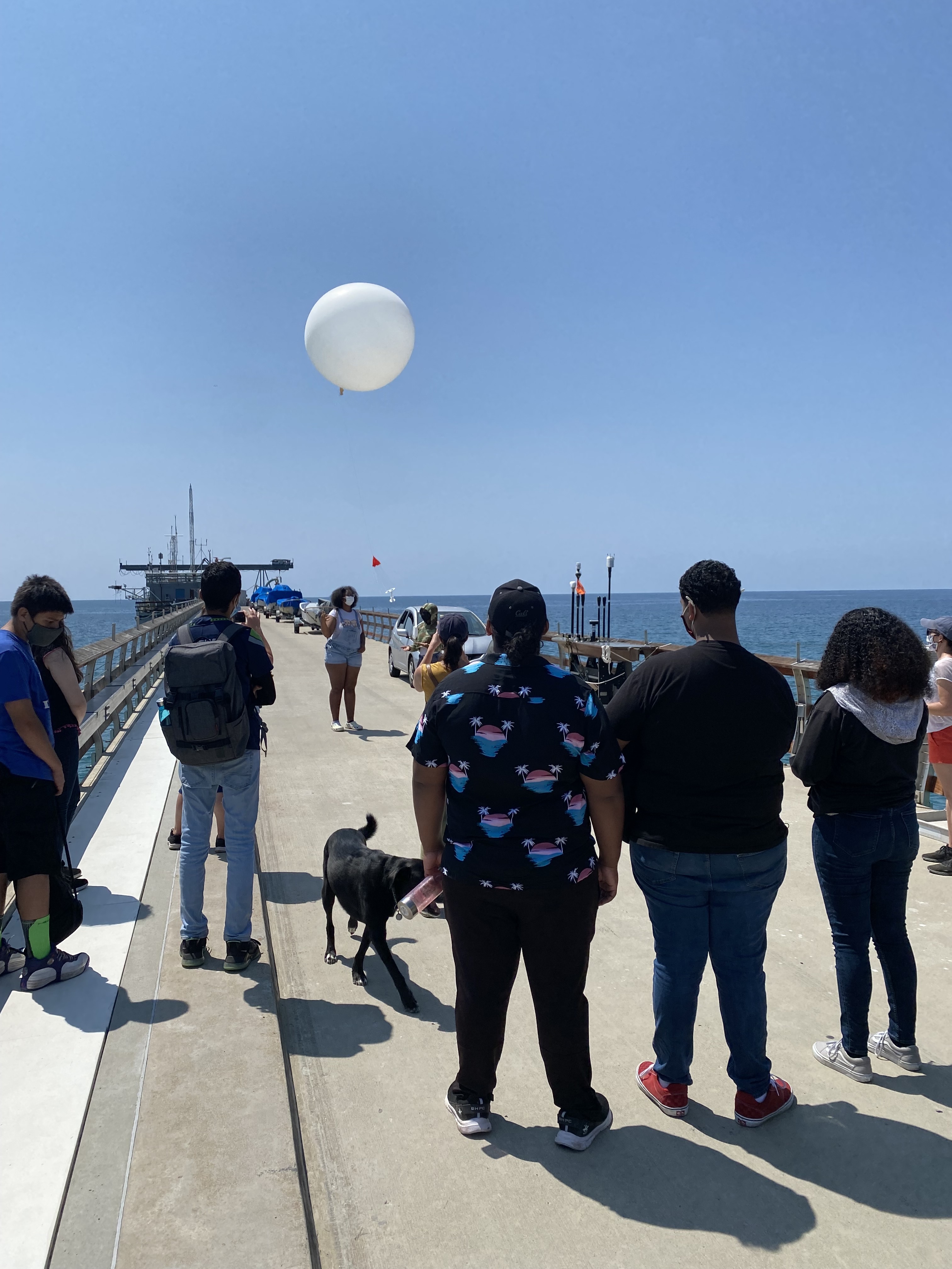
This winter I released radiosondes from Scripps Pier during storm events that passed over Southern California.

How would you describe your time commitment to AR Recon?

During AR Recon I was “on deck” from January-March for storm sampling, checking forecasts, and plotting up storm data for presentations and review. When storms come in, we sample every 3 hours on the hour, day or night, until the storm has passed! This can lead to some very long (but very fun!) nights.

What was your favorite or most memorable moment of AR Recon this year?

Any opportunity to safely come to campus and work with others felt amazing considering pandemic circumstances this winter. I was lucky enough to enjoy watching the surf at sunset on the pier with a coworker and to teach a couple grad students how to launch radiosondes. While during a “normal” year, or at another job, these moments might not have stood out, the folks at CW3E make collaboration and learning with others one of the best parts of my job.

What accomplishments are you most proud of this winter?

I am proud of everything my team has done this winter. Despite ever-changing safety and travel restrictions, we had to start planning our winter months ahead of time and were able to come up with field plans (and back-up field plans) that made everyone feel comfortable and safe. I’m also particularly proud of myself and my team for prioritizing staying connected while stationed across three separate sites all winter long.

Nikki Hathaway is a Flight Director and Flight Meteorologist with the NOAA Aircraft Operations Center (AOC – NOAA Hurricane Hunters).

How would you describe your time commitment to AR Recon?

This season, I was the lead Flight Director for the second half of the season. As the Flight Director, I would listen in on the morning AR Recon 2021 Forecast and Flight Planning Call on our drive to the airport, develop the morning briefing for the flight crew, and then take off and fly the 7–8.5 hour mission. Fly days can last 10 to 11 hours. Most of the time if we are flying a series, these flights are back to back, and we are usually flying multiple days in a row. While in the air, my main objective is to make sure the science is accomplished and the data we collect is representative. The time dedicated to this mission is well worth it, especially when you know the data we are collecting is positively affecting the operational forecast models and providing critical observations over less sampled environments.

What was your favorite or most memorable moment of AR Recon this year?

I am a fairly new Flight Director, I joined the team at AOC in 2019. The 2020 AR Recon season was my first operational mission. I learned so much about our GIV jet during that first deployment, how to be a flight director, analyze data from dropwindsondes, and the overall mission and importance of AR Recon. Each winter, AR Recon presents new and exciting challenges and goals, making each year we fly this mission unique and memorable. Not to mention, we work with an incredible team of dedicated scientists that make the mission and work that much more enjoyable.

What accomplishments are you most proud of this winter?

This last year we accomplished AR Recon under strict COVID-19 protocols while working out of Honolulu, HI. To capture the amount of data that we did, under such challenging times was extremely rewarding. I am very proud of our team and their dedication.

Who inspired you and helped you get to where you are today?

My Mother. She was the first in our family to receive a college degree and she went back to school while raising two little girls, my sister and myself. She taught me how to defy the odds, work hard, persevere, and to never give up on my dreams.

Jennifer Haase is an affiliated faculty member from Scripps Institution of Oceanography. She collaborates on research that develops the use of GPS technology to make atmospheric measurements of temperature and moisture profiles in ARs.

What was your role in AR Recon this winter?

I led the Airborne Radio Occultation data collection and research effort on the NOAA G-IV aircraft and served as Mission Director for one week during AR Recon.

What was your favorite or most memorable moment of AR Recon this year?

My most memorable moment is always when I see the first measurements come out from my ARO system.

What accomplishments are you most proud of this winter?

I got a new piece of equipment installed on the aircraft that will allow us to make measurements in the lowest part of the atmosphere. I have a long way to go to develop the data processing to extract the information about the moisture, but it is a major first step. Additionally, one of my summer interns from 2020 gave a very well received invited oral presentation on her work on the Loon project, describing the potential for balloons to supplement aircraft observations of ARs.

Lieutenant Colonel Devon Burton is a Pilot and Aircraft Commander with the U.S. Air Force.

How would you describe your time commitment to AR Recon?

I spent 15 days on AR Recon this year.

What was your favorite or most memorable moment of AR Recon this year?

Within an hour after takeoff on our mission, we had an issue with the weather equipment that would only allow us to collect data rather than collect and transmit the data. Our options were to A) Continue on the mission knowing that the data we collected would not be available for use in the upcoming forecast model and would only be used to verify the forecast accuracy after the fact, or B) Turn back and try and get it fixed, risking valuable mission time and foregoing some data collection points that could be used for after-the-fact forecast verification. We decided that our duty was to the mission and if there was a chance that we could get our equipment fixed and improve the forecast, we should take it. We coordinated with our maintenance unit on the ground so they could prepare a plan to fix our issue and be ready to execute their plan as soon as we landed. The maintenance team was able to fix the issue in a record 20 minutes and we were back in the air before we knew it. Although the mission was abbreviated, the data we were able to collect made it into the forecast. Our risk paid off and it was a proud moment for our crew.

Carly Ellis is a Field Researcher at CW3E who is primarily responsible for the group’s hydrologic data collection, but also spends a lot of time on their many surface meteorology stations, trip planning, and partner correspondence.

What was your role in AR Recon this winter?

I was stationed in Yuba County this winter, nearby one of our group’s three radiosonde launching locations and many of our surface met stations.

How would you describe your time commitment to AR Recon?

While working remotely and in the field throughout Northern California, I was on-call for radiosonde launches to coordinate with AR Recon flights over the Pacific. Myself and a partner typically launched every 3 hours during an AR, and up to every hour during peak conditions. This sometimes involved overnight stays in the warehouse from which we launched!

Who inspired you and helped you get to where you are today?

My family originally instilled in me a love of the outdoors and taught me how to work with my hands through various home construction projects and through summers spent on the family paving crew. I also had an incredibly fun Geoscience Department in undergrad where every class felt more like recess than work! Beyond that, I’ve been extremely lucky to work with, and be mentored by, a number of supportive scientists who truly love their jobs.

Minghua Zheng is a staff researcher at CW3E. She works on assimilating atmospheric data into models and performs relevant data analyses and numerical modeling. Her research has been focused on the predictability of landfalling atmospheric rivers that can bring high-impact weather events to the US West.

What was your role in AR Recon this winter?

I was the quantitative tool lead and worked with the sensitivity tool team to synthesize the adjoint and ensemble sensitivity products, which provided guidance on where to fly.

How would you describe your time commitment to AR Recon?

4 hours per day. I spent 1 hr on looking into the weather maps before bed to get a better idea of synoptic weather patterns and key features associated with atmospheric rivers. The next morning, I got up at 6 AM and prepared a synthesized slide for a 3-5 min talk during forecast discussions from 8-9 AM. I was also responsible for making sure someone would be leading the discussions every morning and helping with the interpretation of each product if needed.

What accomplishments are you most proud of this winter?

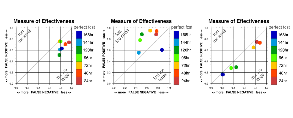
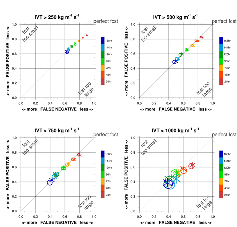
As an English-as-a-Second-Language (ESL) speaker, I overcame my fear of preparing slides in a short time and speaking in front of many people. Another accomplishment is that our BAMS data gap paper, which demonstrates that AR Recon can effectively fill data gaps within atmospheric rivers, was formally published in the last week of AR Recon 2021.

Who inspired you and helped you get to where you are today?

Madame Curie has been my role model. I read her biography when I was 11. Her success as a female scientist and actions motivated me to be a scientist so that I can become an expert in my field and contribute to the progress of science and technology.

Allison Michaelis was a postdoc with CW3E during the previous two AR Recon seasons. She joined this season from her position as an Assistant Professor at Northern Illinois University and is hopeful to continue collaborating with CW3E on numerical modeling of ARs, mesoscale frontal waves, and ARs and climate change.

What was your role in AR Recon this winter?

I was part of the forecast team, contributed to flight coordination support for the NOAA G-IV aircraft, and was on rotation for quantitative tools lead, presenting a synthesis of the adjoint and ensemble sensitivity tools.

What was your favorite or most memorable moment of AR Recon this year?

Probably hitting 40+ briefings – more than any past season! Continuing to beat records of the number of IOPs (Intensive Operations Period) is also a memorable achievement.

Who inspired you and helped you get to where you are today?

This is a toughie! I’m not sure that I can point to any one person. My original career path was to become a high school math teacher, which I was inspired to pursue by several terrible math teachers throughout middle and high school. The aspiration to do better initially led me down the education path. In terms of helping to get me where I am today, I credit several outstanding mentors and role models throughout undergrad and grad school, particularly Dr. Alina Duca (undergrad math professor), Dr. Sandra Yuter (undergrad meteorology professor and mentor throughout graduate school), and Dr. Gary Lackmann (undergrad meteorology professor, graduate school advisor, and mentor throughout graduate school). I would be remiss if I didn’t also give a shoutout to my peers and friends! Surrounding myself with tough, resilient women inspires me everyday.

Allison Cobb is a seasoned Postdoctoral Researcher at CW3E. Her primary focus has been analyzing dropsonde observations that are gathered during AR Recon. She is also interested in air-sea interactions and is investigating this process in atmospheric rivers using regional models.

What was your role in AR Recon this winter?

I shared the roles of AR Recon Coordinator with Anna Wilson and also Flight Planner with Forest Cannon. I also spent some time working with the forecast team early on in the season.

How would you describe your time commitment to AR Recon?

Generally setting aside 6-10 AM for AR Recon work on all active forecast days, and then continuing with my regular day job until 5 or 6 PM. On quieter days, I might finish with AR Recon soon after 9 AM, but on others when working as the AR Recon coordinator, I may be required to work on logistics throughout the rest of the day.

What accomplishments are you most proud of this winter?

Leading a paper that will summarize the AR Recon 2021 season with collaborators from several groups. This paper will highlight all of the observations collected, as well as detail assimilation of data into and impact on model forecasts.

Ava Cooper is a Field Researcher at CW3E who assists with field operations, including preparation and installation of instrumentation and the ground-based winter field sampling done for AR Recon. She also works on snow and hydrology related research.

What was your role in AR Recon this winter?

This winter, I was stationed at the UC Davis Bodega Bay Marine Lab to launch radiosondes during atmospheric rivers and conduct maintenance on our Bodega Bay RadMet station (Micro Rain Radar, disdrometer, and surface meteorology).

How would you describe your time commitment to AR Recon?

During ARs, we were launching radiosondes about every 3 hours (up to every hour during peak storm conditions) for the duration of AR conditions, often 12-24 hours.

What was your favorite or most memorable moment of AR Recon this year?

Tropical storm force winds at the surface during the frontal passage in January! It was wild (~30 mph winds) and took three attempts to get a radiosonde launched during the peak of the surface winds. The frontal passage was in the middle of our first launches for the season and made for good practice getting back in the swing of launching radiosondes!

What accomplishments are you most proud of this winter?

This winter I learned to launch radiosondes by myself! It sounds simple, but being alone with a balloon on a dark, drizzly night is a pretty eerie experience. There are also just enough steps that you feel like you’re bound to forget something but repetition is your friend in the field!

Who inspired you and helped you get to where you are today?

My family is pretty science- and outdoors-focused! While growing up, we went on lots of summer road trips across the Western U.S. and on geology field trips with my dad. My family has given me a lot of support in pursuing a career in science, which I am incredibly grateful for! I also have many awesome mentors, most of whom are women in earth science. My undergraduate mentor, Dr. Anne Nolin, inspired me to get into snow hydrology and continued to provide mentorship throughout my career. I would not have found this career path without her support along the way!

CW3E Publication Notice: Representation of dropsonde-observed atmospheric river conditions in reanalyses

CW3E Publication Notice

Representation of dropsonde-observed atmospheric river conditions in reanalyses

July 16, 2021

Alison Cobb, a postdoctoral scholar at CW3E, recently published a paper in Geophysical Research Letters, along with CW3E co-authors Luca Delle Monache, Forest Cannon, and F. Martin Ralph, titled “Representation of dropsonde-observed atmospheric river conditions in reanalyses” (Cobb et al. 2021). This study contributes to the goals of CW3E’s 2019-2024 Strategic Plan to support Atmospheric River (AR) Research and Applications by assessing the skill of widely used reanalysis datasets to accurately represent AR conditions.

In this study, a large dataset of >1700 dropsondes was compared to three atmospheric reanalysis datasets: ERA5, MERRA-2, and JRA-55. The ability of these reanalyses to provide a ground-truth dataset for the IVT field in and around atmospheric rivers (ARs) is assessed. It was found that bias and error increase with IVT magnitude, although asymmetrically around the AR core. A partitioning of the source of error reveals that humidity contributes more to the difference in IVT above 800 hPa, while wind is the dominant source in the lowest levels (to 950 hPa). This quantification of reanalysis error and bias identifies ERA5 as the dataset with the lowest IVT errors, which is unsurprising, given it is the most recently developed dataset, with the highest resolution and advanced data assimilation.

The Cobb et al. (2021) study was the first of its kind to directly compare such a vast quantity of dropsonde observations in and around ARs to several reanalysis products. An important goal of AR observational campaigns is to retrieve data that will reduce forecast error and uncertainty in real-time. This study has shown the value of these observations to research, assessing model performance and highlighting remaining challenges in representing the observed state in ARs. Results from this study can help to inform users of reanalysis datasets in the northeast Pacific about their skill in relation to IVT, as well as its wind and water vapor components. This work supports ongoing collaborations involving CW3E, NOAA, NRL, U.S. Army Corps of Engineers, NCAR, and ECMWF.

Figure 1: a) Reanalysis IVT against dropsonde IVT calculated using all dropsonde levels, with regression lines marked for each dataset (1-hourly, 3-hourly and 6-hourly samples). b) Reanalysis IVT at 00 UTC 2nd March (2020 IOP 12) in colored contours. Dropsondes within 30 minutes color-coded with dropsonde IVT and shown on inset scatter plots alongside reanalysis IVT. Remaining dropsondes during this IOP marked with black dots.

Cobb, A., Delle Monache, L., Cannon, F., & Ralph, F. M. (2021). Representation of dropsonde-observed atmospheric river conditions in reanalyses. Geophysical Research Letters, 48, e2021GL093357, https://doi.org/10.1029/2021GL093357

CW3E Publication Notice: Modulation of Atmospheric Rivers by Mesoscale Frontal Waves and Latent Heating: Comparison of Two U.S. West Coast Events

CW3E Publication Notice

Modulation of Atmospheric Rivers by Mesoscale Frontal Waves and Latent Heating: Comparison of Two U.S. West Coast Events

July 14, 2021

Allison Michaelis, an Assistant Professor at Northern Illinois University, along with co-authors Andrew Martin (Portland State University), Meredith Fish (Rutgers University), Chad Hecht (CW3E) and F. Martin Ralph (CW3E), recently published a paper titled “Modulation of Atmospheric Rivers by Mesoscale Frontal Waves and Latent Heating: Comparison of Two U.S. West Coast Events” in Monthly Weather Review. This study supports CW3E’s Strategic Plan involving Atmospheric Rivers (AR) Research and Applications by quantifying how diabatic processes contribute to mesoscale frontal wave (MFW) development and AR-MFW interactions.

Michaelis et al. (2021) takes a novel modeling approach by simulating two AR events with associated MFWs that impacted Northern California’s Russian River watershed using the Model for Prediction Across Scales-Atmosphere (MPAS-A) with and without the effects of latent heating. Despite the storms’ contrasting characteristics, diabatic processes within the system were critical to the development of MFWs, the timing and magnitude of integrated vapor transport (IVT), and precipitation impacts over the Russian River watershed in both cases. Low-altitude circulations and lower-tropospheric moisture content in and around the MFWs were considerably reduced without latent heating, contributing to a decrease in moisture transport, moisture convergence, and IVT. Differences in IVT were not consistently dynamic (i.e., wind-driven) or thermodynamic (i.e., moisture-driven), but instead varied by case and by time throughout each event. For one event in mid-December 2014, AR conditions over the watershed persisted for 6 h less and the peak IVT occurred 6 h earlier and was reduced by ~17%; weaker orographic and dynamic precipitation forcings reduced precipitation totals by ~64%. Similarly, turning off latent heating shortened the second event from late-January 2010 by 24 h and reduced precipitation totals by ~49%; the maximum IVT over the watershed was weakened by ~42% and delayed by 18 h.

Removing diabatic processes resulted in clear dynamic and thermodynamic changes which influenced the development of MFWs and their interactions with ARs, underlining the importance of diabatic processes in AR-MFW interactions. Sufficient representation of variables and processes contributing to latent heat release (e.g., water vapor content, vertical motion, microphysical processes, and their subsequent effects and feedbacks), and by extension, accurate initial conditions of the aforementioned variables, is therefore imperative for the accurate representation of MFWs, AR evolution, and precipitation estimates, especially on a watershed scale.

Figure 1: (Top row) 6-hourly accumulated mean areal precipitation (mm) ending at the time indicated on the abscissa for the Russian River watershed (blue bars) and 6-hourly mean areal IVT (kg m-1 s-1) for the Russian River watershed at the end of the precipitation accumulation period (black line) for the December 2014 (a) control (CNTL) and (b) no-latent heating (noLH) simulations. Red asterisks represent the maximum IVT (kg m-1 s-1) over the Russian River watershed at each time. (Bottom row) 72-h accumulated precipitation (mm; 12 UTC 10 December – 12 UTC 13 December) for the December 2014 (c) CNTL, (d) noLH, and (e) noLH minus CNTL simulations. The 72-h storm total for the Russian River watershed is indicated in the bottom left of (c) and (d). The no-latent heating minus control absolute and percent differences are indicated in the bottom left of (e). The Russian River watershed (~39ºN, 123ºW) is outlined in black in all panels.

Figure 2: (Top row) 6-hourly accumulated mean areal precipitation (mm) ending at the time indicated on the abscissa for the Russian River watershed (blue bars) and 6-hourly mean areal IVT (kg m-1 s-1) for the Russian River watershed at the end of the precipitation accumulation period (black line) for the January 2010 (a) control (CNTL) and (b) no-latent heating (noLH) simulations. Red asterisks represent the maximum IVT (kg m-1 s-1) over the Russian River watershed at each time. (Bottom row) 54-h accumulated precipitation (mm; 12 UTC 24 January – 18 UTC 26 January) for the January 2010 (c) CNTL, (d) noLH, and (e) noLH minus CNTL simulations. The 54-h storm total for the Russian River watershed is indicated in the bottom left of (c) and (d). The noLH minus CNTL absolute and percent differences are indicated in the bottom left of (e). The Russian River watershed (~39ºN, 123ºW) is outlined in black in all panels.

Michaelis, A. C., Martin, A. C., Fish, M. A., Hecht, C. W., & Ralph, F. M. (2021). Modulation of Atmospheric Rivers by Mesoscale Frontal Waves and Latent Heating: Comparison of Two U.S. West Coast Events, Monthly Weather Review (published online ahead of print 2021), https://doi.org/10.1175/MWR-D-20-0364.1

Congratulations to Dr. Osborne – CW3E Graduate Student Successfully Defends Dissertation

Congratulations to Dr. Osborne – CW3E Graduate Student Successfully Defends Dissertation

June 29, 2021

The fifth CW3E PhD student has successfully defended her dissertation. Dr. Tashiana Osborne’s defense was held on Tuesday, June 29, 2021. Her dissertation title is “Extreme Rain-Snow Level Variations during California Storms” and includes three chapters that will be submitted to the Journal of Atmospheric and Oceanic Technology and the Journal of Hydrometeorology. Tashiana’s committee members were Art Miller (Chair), Marty Ralph and Joel Norris (Co-Chairs), Amin Dezfuli, Myrl Hendershott, Lane Kenworthy, and Shang-Ping Xie. Funding for Tashiana’s dissertation came from her National Science Foundation Graduate Research Fellowships Program fellowship, her San Diego Fellowship, and her UC President’s Dissertation Year Fellowship. Additional funding was provided through FIRO and the AR Program, both under PI Marty Ralph.

Tashiana has been selected to be a Postdoctoral Scholar working with Benjamin Zaitchik at the Johns Hopkins University in Baltimore, MD. Her work there will involve setting up a hydrology model and science-to-action framework in order to implement an early warning forecast system for malaria in regions of South America. She will also be consulting for a stealth-mode startup company focused on climate change.

Due to the ongoing COVID-19 health crisis, Tashiana defended her dissertation virtually. CW3E is incredibly proud of Tashiana’s accomplishment today and all that she has done (these links are a very small selection!) throughout her PhD. We look forward to honoring her with an in-person celebration as soon as the health precautions are no longer necessary.

Dr. Tashiana Osborne summarizing her dissertation work during her defense.

Dr. Tashiana Osborne completing her dissertation defense with her co-advisor Dr. Joel Norris beginning the open questions session.

Hydrology Post-Doc Position at Scripps Institute of Oceanography, La Jolla, CA

Hydrology Post-Doc Position at Scripps Institute of Oceanography, La Jolla, CA

June 29, 2021

To apply: please send CV, cover letter and 3 references to Dr. Ming Pan, m3pan@ucsd.edu

The Center for Western Weather and Water Extremes (CW3E) at the Scripps Institute of Oceanography (SIO) is seeking a postdoctoral scientist to carry out the hydrologic modeling and data analysis in order to (1) study the terrestrial water cycle and its variability at regional to global scales, (2) apply hydrologic modeling for flood and water resources management (rivers, groundwater, and reservoirs), especially in areas affected by atmospheric rivers (AR), and (3) investigate and improve hydrologic forecasts and reservoir operations in those areas.

CW3E consists of 50+ passionate scientists who develop and operate state-of-the-art modeling (e.g., CW3E version of the Weather Research and Forecasting model tailored for extreme events over the Western US – West-WRF) and observing (e.g., Atmospheric River Reconnaissance) systems to improve forecast capability for weather and water extremes in Western US and to enable more effective policies and practices in the region. CW3E aims to revolutionize the physical understanding, observations, predictions/projections of extreme events in Western North America at different time scales from days to decades, including atmospheric rivers, the North American summer monsoon and their impacts on floods, droughts, hydropower, ecosystems and economy. CW3E practices UCSD Principles of Community to create a climate of fairness, cooperation, and professionalism.

This position is in part supported by National Aeronautics and Space Administration (NASA) under the NASA Energy and Water Transport and Exchanges (NEWTEx) program, with its overall goal to better understand the fluxes and storages in the global water/energy cycle and its variability at seasonal and long-term scales. The work here will focus on the terrestrial water cycle and the runoff/streamflow in particular. The post-doc will also provide research support for CW3E’s Forecast Informed Reservoir Operations (FIRO) program. FIRO is a reservoir-operation strategy that uses enhanced monitoring and improved weather and water forecasts to inform decision making to selectively retain or release water from reservoirs to optimize water supply reliability and environmental co-benefits and to enhance flood-risk reduction.

The post-doc will work closely with Dr. Ming Pan and the weather and hydrology teams at CW3E. Applicants should be self-motivated and hard-working. Good written and verbal communication skills, including the ability to produce scientific publications and presentations and meet project milestones are required. The ideal candidate would have experience with hydrologic/river model calibration, application, and verification. Strong analytical backgrounds with a Ph.D. in meteorology, hydrology or environmental or civil engineering is preferred. Programming experience working in a Linux/Unix environment with experience in scripting languages such as Python and R as well as in supercomputing is desired.

The University of California is an Equal Opportunity/Affirmative Action Employer. All qualified applicants will receive consideration for employment without regard to race, color, religion, sex, national origin, disability, age, protected veteran status, gender identity or sexual orientation.

CW3E Publication Notice: Better Subseasonal-to-Seasonal Forecasts for Water Management

CW3E Publication Notice

Better Subseasonal-to-Seasonal Forecasts for Water Management

June 25, 2021

CW3E researcher Dr. Mike DeFlorio, along with co-authors Dr. F. Martin Ralph (CW3E Director), Dr. Duane E. Waliser (NASA JPL/CalTech; Chief Scientist of the Earth Science and Technology Directorate), Jeanine Jones (California Department of Water Resources; Interstate Resources Manager) and Dr. Michael L. Anderson (California Department of Water Resources; State Climatologist) recently published an article in EOS titled “Better Subseasonal-to-Seasonal Forecasts for Water Management”. This effort is supported by the California Department of Water Resources Atmospheric River Program Phase II.

The purpose of this EOS article is to provide an overview of emerging methods in Subseasonal-to-Seasonal (S2S) prediction (2-week to 6-month lead time) that have the potential to support better water management in the western U.S. region. In addition, specific decisions and actions relevant to water resource management that could be affected by improved S2S prediction are identified as a function of lead time. Background context is also given in this article regarding: a) California’s uniquely high interannual variability of total precipitation, which presents a fundamental challenge for water management; b) historical attempts at skillful prediction of western U.S. precipitation, and how emerging methods have the potential to improve upon these previous efforts; and c) the collaboration between researchers at CW3E/JPL (and collaborating institutions) and stakeholders at DWR in designing S2S research methodologies and S2S experimental forecast products that can have more potential benefit to end users in the western U.S. region.

Figures 1 and 2 from the article are included below. They describe, respectively, the lead-time dependent decisions and physical processes related to S2S predictability of precipitation over the western U.S. region, and the quantities of interest and methods investigated at S2S lead times by the CW3E/JPL S2S team.

Figure 1: Overview of lead-time dependent water management decision support, along with physical processes that affect predictability of precipitation over the western United States.

Figure 2: Quantities of interest, methods, and lead times investigated by CW3E/JPL S2S team to benefit water management in the western United States.


DeFlorio, M. J., F. M. Ralph, D. E. Waliser, J. Jones, and M. L. Anderson (2021), Better subseasonal-to-seasonal forecasts for water management, EOS, 102, https://doi.org/10.1029/2021EO159749

CW3E AR Update: 10 June 2021 Outlook

CW3E AR Update: 10 June 2021 Outlook

June 10, 2021

Click here for a pdf of this information.

Multiple Late Season Atmospheric Rivers are Forecast to Impact Northern California and the PNW this Weekend

  • This first AR is forecast to make landfall on Friday while the second and potentially stronger AR is forecast to make landfall late on Saturday
  • The first AR is forecast to bring weak to moderate AR conditions to far Northern California and Southern Oregon
  • Several GEFS ensemble members suggest the second AR could bring strong AR conditions (IVT >750 kg m–1 s–1) to Coastal OR, but there is higher forecast uncertainty surrounding this AR compared to the first
  • The WPC is forecasting as much as 2–4 inches of precipitation over some of the higher elevation locations in Northern CA, OR, and WA
  • While these ARs are forecast to bring impressive IVT magnitudes to the USWC for June, they are likely to be less productive than an AR of similar magnitude during the Winter
  • Due to the extremely dry conditions across the U.S. West, any precipitation produced by these ARs will be beneficial with little to no hazards, though the precipitation will not be enough to mitigate the extensive drought conditions

Click images to see loops of GFS IVT & IWV forecasts

Valid 1200 UTC 21 April – 1200 UTC 29 April 2021


Summary provided by C. Hecht, C. Castellano, J. Kalansky, and F. M. Ralph; 10 June 2021

*Outlook products are considered experimental